This is an archive of past discussions for the period 2015. Do not edit the contents of this page. If you wish to start a new discussion or revive an old one, please do so on the current main page.
I am working on a piece about the Cuxtal Ecological Reserve. It contains 7 haciendas and the pueblos they are in, 2 police commissary stations, 12 minor ruins and 6 cenotes. I haven't been able to find a map of the whole thing. But, I plotted the route on Google maps. Issue is, I don't know how to make that into a photo. I have no idea how to find or use Open Streetmap. And all the points aren't showing. They should be in order starting at the reserve. Here's the map and I've listed the points below: [1]
Cuxtal Ecological Reserve on Calle 161 between Calle 50 and Calle 50C
I have been unable to find any map of the entire historic preservation area. I cannot find a map on Wikipedia that isn't for the whole country of Mexico or the entire state of Yucatan, but the one that I found at least shows just the state, so hopefully it can be scaled down? I checked the corresponding articles on the Spanish Wiki thinking they might have info but they did not have a map. Would it be possible to make a map from this? Thank you for your help. SusunW (talk) 00:08, 9 May 2015 (UTC)
I found some maps and noted the above images on Commons, middle one appears to be a detail of the third one, but again, it is too small and gives insufficient information to indicate the places included in the image. Something similar to this, but even omitting the extraneous "outside of Merida" areas Progresso and Motul and including the points above would be ideal. [3]. The middle one might actually work if you could see it, but it is a tiny initial image. SusunW (talk) 13:53, 9 May 2015 (UTC)
Graphist opinion(s)
I could help you with that but probably not for a month. So if nobody else have helped you give me a ping in a month if that is OK with you, thanks. --Goran tek-en (talk) 17:52, 9 May 2015 (UTC) @Goran tek-en: Thank you. If someone doesn't pick up the request before then, that would be very much appreciated. SusunW (talk) 05:02, 10 May 2015 (UTC)
Request taken by Goran tek-en (talk) 09:41, 2 June 2015 (UTC). Yes I will start to work on it. To start with I would like to understand more what you are expecting/in need of. As I understand it you want a kind of tour map for that area with the different sites marked out. The underlying map is more or less just so people locate them selves, is this right?
If not then you will have to describe what you want
It may be that the center image would be perfect, if it were enlarged. It is so small that it is hard to tell, but it appears to show the reserve and in the top right hand corner shows the adjacency/proximity to Mérida. All the rest of the state is irrelevant, IMO. Then I would like all the communities which are part of the reserve to be indicated (the 7 haciendas and two larger towns, i.e. 9 points to be indicated). SusunW (talk) 15:14, 2 June 2015 (UTC)
@Goran tek-en: I would like the focus to be centered on the reserve. Looking at the central blue image, if you just enlarge that image, it appears the top right image of the reserve and Mérida and the other image of just the reserve are similar in size. Would it be possible to leave the top right image the same size it is now, since it is merely to give the visual reference to proximity with Mérida, and enlarge the reserve to show more detail including the communities? Please ping me with responses. Though I have "watched" this page, I do not seem to get messages from it and have to remember to come back and check it. Thank you again for your help. SusunW (talk) 15:27, 2 June 2015 (UTC)
@SusunW: I have the same problem with the watch function. Now you can look at a first draft.
You have to tell me if the area is at you want it.
I put out numbers if you want the different locations to be explained in the text, but that's up to you.
Is 10 Right, I'm not sure?
If you want names of urban areas, tell me which ones.
This is to show the "track" (give me the right name for it) and the other maps will come after this is done.
@Goran tek-en: Yay! It looks good, but 10 is not at the top. It is here Hacienda San Antonio Tahdzibichén. And yes, I'd like the names of the places the numbers correlate to, to show--can that be in a legend? I don't think we need other names, except if you want to put Mérida on the tiny proximity image in the top corner, so people get the relationship. With this superimposed (is that the correct terminology) over the reserve area like in the blue map in the middle. Am I asking too much? I'm not exactly sure what to call the "track" either. The explanations translate to something like "driving tour"? SusunW (talk) 20:03, 7 June 2015 (UTC)
@SusunW: Have you done something with your google track, I can't see the blue driving tour any more?
New draft to look at. You are NOT asking for to much. You can ask for anything and then I will tell you if I can/will do it, no problem from my side.
Check if 10 is correct now?
The numbers was more of an intermediate thing so that we could check the map. If you want to keep the numbers then I think that the names should be in the information of the file, not in the legend.
@Goran tek-en: Oh yeah, I like it! Especially that it shows where in Mexico it is and the proximity to Mérida without those things taking the focus off of the reserve area. The points all appear to be named properly and in the right locations. Now can you put the blue reserve like it is shown in the middle image around all this area? Mayhaps we don't want it to be blue, we will lose our visibility of the driving tour, but since it is an ecological reserve possibly a light green? SusunW (talk) 18:12, 13 June 2015 (UTC)
@SusunW: This middle image is really small and I can't really get the roads to match our map. I have tried to find a better map but haven't. Maybe you have a better map of the ecologic reserve? --Goran tek-en (talk) 15:00, 14 June 2015 (UTC)
@Goran tek-en: Which is how we got here in the first place. I can find nada. That map is too tiny and really unusable. The one on #4 attachment is no better and shows no streets, but those are the only two images I have been able to find of the entire reserve and none of those give the haciendas or towns. *sigh* I will try to find something else, but it is doubtful that anything exists short of obtaining something directly from the city of Mérida.SusunW (talk) 15:15, 14 June 2015 (UTC)
@Goran tek-en: One last search, which may be most helpful yet. If you look at this image [4] it gave me the idea that maybe it was following the municipalities? So then I saw this image [5]. These clearly make it appear that the east, north, and west boundaries mostly follow municipality boundaries. The southern does not, as per this [6] Don't know if any of this helps, let me know. SusunW (talk) 17:12, 14 June 2015 (UTC)
I haven't changed the map area but if this reserve area is correct I will have to do that and add road segments I have removed before. It's always good if you tell the graphic worker up front everything which is supposed to be include in the map. That is the best way so any of us don't have to redo or do work in vain. Check the green area and then I will correct the rest. --Goran tek-en (talk) 19:00, 15 June 2015 (UTC)
@Goran tek-en: Wow! It looks great. If you could make the reserve a little darker shade that would be perfect, but I am happy with it as it is. I wish I had found those images before. I have no idea why they do not come up with a search for the reserve, nor why the City of Merida site had no maps on their site. I only found them when I put "Mapa" as the first word in the search string. SusunW (talk) 19:18, 15 June 2015 (UTC)
@SusunW: I had to redo some work so you will have to check EVERYTHING in this draft. New draft for you to give me feedback on.
Eventually I will need the following;
@Goran tek-en: It looks better than I dreamed! Thank you so much. Can we eliminate the brown urban areas within the reserve near Mérida? Specifically, take out the brown area along the road in the center coming down from the "Cuxtal Ecological Reserve"; then take out the brown area above Hacienda San Antonio Tahdzibichén (a small bit around the hacienda will highlight it, but the larger area loses the top boundary of the reserve); and the brown area on the left above Hacienda Santa Cruz Palomeque (as again, it obscures the upper boundary of the reserve).
I think we name it Cuxtal Ecological Reserve
the description is "An ecological and historic preservation area adjacent to Mérida, Yucatán, Mexico"
Categories: Yucatán, Mexico; Mérida, Mexico; ecological reserve(s); historic preservation area(s); Haciendas of Yucatán; (I don't know how many categories it should have, but each of the named places have photographs in commons so could effectively have categories?)
Thank you again for your work. I am really, really pleased at how well you have done with such sketchy information. SusunW (talk) 16:22, 17 June 2015 (UTC)
@Goran tek-en: you are BRILLIANT! It is what I was hoping for, something useable, that makes sense, covers all the important parts of the reserve, orients it to Mérida and is big enough that you can see it, unlike that original image. Thank you so much for doing this! I think that is exactly what I needed. SusunW (talk) 19:21, 17 June 2015 (UTC)
@Goran tek-en: THANK YOU! THANK YOU! THANK YOU! I have no idea how to add categories on commons, but will busily add the map to all of the places on the reserve now. Truly appreciate your help. SusunW (talk) 15:47, 18 June 2015 (UTC)
@SusunW: You add categories on Commons in the same way as on Wikipedia, by putting [[Category:(whatever)]] at the bottom of the file description page - for example, here's one that I did a few days ago. You can do it manually, or using a gadget such as HotCat (which is the same as on Wikipedia), or Cat-a-lot (which is only on Commons). Be careful which categories you choose, as the ones on Commons are not necessarily the same as on Wikipedia. --Redrose64 (talk) 16:10, 18 June 2015 (UTC)
TEST3:Rectilinear(?) dot assignment contradicts map projection
Black Xes are ports and should be on the coast; See lower right; Baku is debatable Blue circle: no Wikipedia ports in this region; Chechen Island: Google Earth has this at 44 N
Is this worth fixing? It appears that this map uses rectangular coordinates to assign dots while the map uses a different projection. This shows up mainly for ports which should be on the coast. I assume you already know this, but it would be a good thing to fix if there were a practical way. Benjamin Trovato (talk) 17:33, 6 January 2015 (UTC)
The map was made by me, it uses the conic equidistant projection. I don't know how do you do this in English Wikipedia, but in Russian Wikipedia we use these formulas:
x = {{#expr: sin({{{1}}}/92.433-0.4848)*(1292.56-12.1988*{{{2}}})+46.08 }}
y = {{#expr: cos({{{1}}}/92.433-0.4848)*(1662.65-15.6916*{{{2}}})-960.13 }}
@Goran tek-en: Broadly speaking, any map over which a coloured dot is superimposed. More specifically, a map generated using {{location map}} and similar, see for example the map in the infobox at Varanasi. This appears because {{Infobox settlement}} (which uses {{location map}} as a subtemplate) has been given three parameters: |pushpin_map=India Uttar Pradesh|latd=25.28|longd=82.96 --Redrose64 (talk) 20:26, 19 March 2015 (UTC)
What I don't understand is that the map you refer to as, "like this" is to me showing the whole of Uttar Pradesh which is a much large type of district. So get back to me on this, thanks. --Goran tek-en (talk) 11:50, 4 May 2015 (UTC)
Dear Goran tek-en, if the rivers, roads, railroads, water bodies etc can be included without great difficulty then it will be great. Like the example, it is intended that user should be able to pin location on the map. Thanks a lot. Arun Kumar SINGH (Talk) 05:01, 8 May 2015 (UTC)
When I gather information for a map it often includes roads, railroads, etc so it's not so bad to add it. I have made two versions for you to look at.
We can upload both versions and then you use the one you need, but you can also get anything in between those two. It's easy to add/remove stuff just as you like. Have a look at them and give me feedback, thanks. --Goran tek-en (talk) 18:09, 9 May 2015 (UTC)
Dear Goran tek-en, just a small observation in this map. The legend at bottom left of the map overlaps with the boundaries and if a location is tagged there then the legend will overlap with the pin. Can something be done about this? Cheers, Arun Kumar SINGH (Talk) 07:09, 14 May 2015 (UTC)
I will fix your point above and upload a new version.
I didn't know how to get the "corner" coordinates so I did it manually. Therefore I'm not sure they are correct so you should check them. If you know of a good way to obtain them please tell me.
Also I do not know what you mean by "N/S stretching XXX%" so I left that like that. You will have to fill it out and please tell me what it means and how to obtain that information so I can learn, thanks. --Goran tek-en (talk) 16:53, 14 May 2015 (UTC)
@NordNordWest:Thanks for that help and could you please explain how you got the coordinates because I only know that you can do it manually in a map like OSM, GoogleMaps etc. --Goran tek-en (talk) 09:10, 15 May 2015 (UTC)
I used Google Earth, inserted the map as an overlay and fitted it in as good as possible. The rivers, roads and railroads made it quite easy. NNW (talk) 09:33, 15 May 2015 (UTC)
Hello NNW, good to see you. I must thank you for your map of Uttar Pradesh, I have personally used that map in several dozen articles I wrote. Coming back to the subject, I tried using the map again on Durga Mandir, Varanasi and got script which redirects to here. I noticed that you are not very active on Wikipedia these days and hence sent you an email and also contacted Bgwhite for help (just FYI). Can you please help? Many thanks. Arun Kumar SINGH (Talk) 15:29, 15 May 2015 (UTC)
Thanks, the only thing I can say is that the next time be sure to use the "New request" link at the top of the page as that gives us all the code we need. I added "resolved" now as this triggers the archive function. --Goran tek-en (talk) 19:08, 15 May 2015 (UTC)
Inconsistent contemporary borders
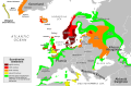
Map of Norse expansion
Article(s)
Eight en:wp articles and thirteen non-articles, plus lots of pages on other wikis
Request
This map displays the current borders of the European, Asian, and African countries that are partially or totally included in the areas covered by the maps. However, some borders are missing; for example, it looks like Andorra's an island in the large country of Francespain (no border in the Pyrenees), and Romania has no separate identity; it's part of the country of Bulgariaromaniaukraine. Could you fix these errors (and others; I see Poland-Lithuania and Finland with its neighbors), or could you simply remove today's borders? I'm more inclined toward the latter choice, partly because I guess it's easier (no need to draw the new borders) and because I don't see why today's boundaries are hugely relevant to a mediæval context, especially because most viewers either won't need the current borders to understand the map, or they'll be weak enough on their geography that the current borders won't help them much at all. Nyttend (talk) 02:14, 15 May 2015 (UTC)
The creator, instead of taking a blank map, decided to take a map with some contemporary borders in it. The contemporary borders are not the thing that matters in this map though, but the extent of Viking settlements, as depicted in the map with colours. One could take away these contemporary borders. Wereldburger758 (talk) 05:05, 20 May 2015 (UTC)
Description of third image (if needed; don't request too many at once, though)
Article(s)
massively in-use, across multiple wikis in various languages[[]]
Request
There is a rather serious error in the english-version's map-legend, which appears to have been the result of a mis-reading or mistranslation. to witt: where in the english legend the colour white indicates "after 1500 A.D.", in the french original the actual/original wording indicates "after 1500 (B.C.)" (ap = apres). examining the white areas of the map itself CLEARLY shows the error, in that it is beyond absurd to suggest that these places did not achieve bronze-age technology until "after 1500 A.D.". tangentially, i think the map itself may be innaccurate in showing the diffusion of bronze age technology; in the lower euphrates-tigris area & in north africa, west of egypt, at least. however, that is a "deeper issue". the matter at-hand is that the english legend needs to be corrected to indicate that the white areas are dated to "after 1500 B.C." & 'not A.D. -- Lx 121 (talk) 11:17, 3 May 2015 (UTC)
It would be great to have this exact map, but with the term Ancestral Puebloans replacing Anasazi, which is no longer the preferred term. RO(talk)19:16, 5 May 2015 (UTC)
I'm not sure what you mean. Do you want a map like the above, but with the HOHOKAM and the MOGOLLÓN, and their coloured patches, removed? Maproom (talk) 21:23, 7 May 2015 (UTC)
Yes, exactly. Also the Gila, Casa Grande, and Pueblo Grande markers removed. Is that doable? RO(talk)21:33, 7 May 2015 (UTC)
I could do that easily. But experience has shown me that uploading the result to Wikipedia Commons, as a new work derived from a work already at Commons, will fail: someone there will delete it as not having a valid copyright tag. See this message for an example. I have already spent too much time trying to find out what bureaucratic hoops I am meant to jump through to get such an image accepted, and am not willing to spend more. Maybe some regular here can advise me?81.156.188.63 (talk) 06:37, 8 May 2015 (UTC)
So what's the trick to uploading an image that is a derivative of a work already on Commons? What do you put in the license field? And what else do you have to do? Or is there a danger that the image you created will be deleted in a month or two for lack of a valid licence? Maproom (talk) 07:37, 9 May 2015 (UTC)
When uploading a derivative file, I make sure that when I upload it, I select the "This is not my file"-box Then I choose the same copyright tag as the original uploader has done. And I mention his name and the original file. That should do it. When someone objects to your derivative upload, then let him explain it to you. If you still don't understand it or if you think it is wrong, go ask for help on a help page or try to get some help from an administrator. Regards, Wereldburger758 (talk) 08:37, 9 May 2015 (UTC)
I have been using the Special:Upload page. Maybe that is a mistake. I can't find a "This is not my file" box on it, and its "Licensing:" box only allows a restricted number of choices, which may not include the license from the image I have modified. I have tried searching Commons for a better upload form, and failed to find one. There's some advice at the top of the Special:Upload page, "New! Try the Upload Wizard instead", but it does not link to a wizard. What upload form are you guys using? Maproom (talk) 10:05, 9 May 2015 (UTC)
When uploading a new work of my own, I select from the list at "Licensing"; but when uploading a derivative work, I leave that alone (so that it remains showing "None selected", "None selected (add a license tag in the permission field above, or this file will be deleted)" or similar). Instead of selecting from that list, I copy the license tag from the original image and paste it into the "Permission" box if there is one, otherwise at the bottom of the biggest free-form text box (which might be titled "Summary" or "Summary (also add a license tag if those below do not apply):" or some such). --Redrose64 (talk) 14:41, 9 May 2015 (UTC)
A better locator map of Telangana in correct equirectangular projection, Attempted myself and succeeded., check the picture on the right--Arjunaraoc (talk) 09:35, 10 May 2015 (UTC)
Hi, here is a first try. This is a blank map similar to Guatemala_Topography.png. If this seems OK for you I will add the geographical names in English. Then I will need your help to translate it in Spanish. Thanks --Ikonact (talk) 21:10, 15 May 2015 (UTC)
Hello, it does look exactly like what I was looking for. One if these days I should learn to draw these maps if I get the time... If you can upload the version with the English names on it I can translate them into Spanish and upload a Spanish version of the map, no problem with that. Thanks a lot!--Rowanwindwhistler (talk) 21:33, 15 May 2015 (UTC)


,_Yucat%C3%A1n_(06).jpg)
 Request taken by Goran tek-en (talk) 09:41, 2 June 2015 (UTC). Yes I will start to work on it. To start with I would like to understand more what you are expecting/in need of. As I understand it you want a kind of tour map for that area with the different sites marked out. The underlying map is more or less just so people locate them selves, is this right?
 Map of Norse expansion
 eng version
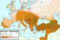 french original

 Map of Puebloan peoples


 Done Wereldburger758 (talk) 05:14, 9 May 2015 (UTC)
 Andhra Pradesh Equirectangular projection map is available
 Telangana map not in equirectangular
.svg)


 Topographic map of Guatemala
![[4]](http://www.scielo.org.mx/img/revistas/peni/v6n1/a3f1.jpg)
![[5]](https://upload.wikimedia.org/wikipedia/commons/b/b9/Merida_localidades.svg)
![[6]](https://s3-eu-west-1.amazonaws.com/infogram-particles-700/Yuritzin1361048504.gif)