
User:Sillyputty1967/sandbox
Mills County | |
|---|---|
.jpg) Mills County Courthouse (north side) | |
 Seal | |
| Motto: Meat Goat Capital of America | |
 Location within the U.S. state of Texas | |
 Texas's location within the U.S. | |
| Country | |
| State | |
| Founded | March 15, 1887 |
| Named for | John T. Mills |
| Seat | Goldthwaite |
| Largest city | Goldthwaite |
| Government | |
| • Commissioner's Court | Commissioner's Court |
| Area | |
| • Total | 749.8 sq mi (1,942 km2) |
| • Land | 748.2 sq mi (1,938 km2) |
| • Water | 1.6 sq mi (4 km2) 0.2% |
| Population (2020) | |
| • Total | 4,456 |
| • Estimate (July 1, 2021) | 4,480 |
| • Density | 6/sq mi (2/km2) |
| Time zone | UTC−6 (Central) |
| • Summer (DST) | UTC−5 (CDT) |
| ZIP Codes | 76844, 76864, 76890, 76870, 76880 |
| Area code | 325 |
| Congressional district | 11th |
| Website | www |
Mills County, created on March 15, 1887, out of four existing counties—Brown, Comanche, Hamilton, and Lampasas—is the most centrally located county in Texas.[1] The 2020 census reports a population of 4,456.[2] The county seat is Goldthwaite.[3]
History[edit]
The Tonkawa originally occupied the territory that was to become Mills County, and there are numerous vestiges from their campsites that remain across the county, including cooking middens.[4] Pedro Vial visited the area that would become Mills County in 1786 and 1789 while traveling between San Antonio and Santa Fe, and he is thought to be the first white man to explore the country.[5] Pre-Mills County was located along the southeastern edge of a large buffalo range, which attracted Comanche hunting trips.[5] Native tribes moved through the area via what locals called "The Comanche Trail," which led to southern Texas.[4] Starting in the 1840s, aggressive groups of Comanche and Apache pushed the Tonkawa out and raided the area in an effort to keep control of it as late as 1850, frequently stealing horses and scalping settlers who had started to move there in numbers after 1855.[4][6][7][1][5] The earliest settlers arrived at time when there were no fences and land was free.[1] Eventually the Apaches moved west, leaving the Comanche in control.[5] In 1854, the Texas Legislature appropriated land located on the Texas frontier, built a series of reservations, and moved the natives there starting in 1855, yet there continued to be native incursions into white settlements.[5] In 1835, the General Council of Texas sent the first Texas Rangers to aid settlers.[1] By the mid 1870s, native violence began to diminish, yet leading up to the 1880s, Comanche and Kiowa continued to terrorize the area.[8][7] Comanches raided Williams Ranch in the late 1870s, the last recorded incursion.[1]
The earliest communities in pre-Mills County were Center City, started in 1847, followed by Hanna Valley in 1854.[7][1] One source identifies the David Morris, Sr., and Dick Jenkins families as the earliest pioneers in the area, who settled south of present-day Center City in 1852.[4][1] Killed by the natives, Dick Jenkins (1825–1866)[9] is thought to be the first person buried in what was to become Mills County.[1] Williams Ranch, established in 1855 in Brown County, was the first community that developed into a large, dynamic town after establishing trade with Mexico and serving as a major center for cattle trade, capitalizing on its location near the Western Cattle Trail.[4][7] The town served as the "headquarters" of the West Texas frontier and expected to serve as the county seat.[5] A telegraph line passed through Williams Ranch, connecting Austin and Concho (San Angelo), and was thought to be the longest line in the United States.[5] A federal military facility, Camp Colorado, was established in 1856, near the community of Ebony.[5]
Numerous wagon and stage coach trails crisscrossed the area during this time.[4] "Fort Phantom Hill Trail," a military route that connected Fort Phantom Hill and Austin, passed through Mills County.[4]
Early settlers in the mid 1850s represented a range of faiths, led in numbers by the Methodists.[4][1] During the county's formation days, denominations were less important.[10] Early sermons were delivered by circuit riders.[4] Later brush arbor revivals became popular before camp meetings started attracting congregants.[4]
During the Civil War and following Reconstruction, an exodus of people moved west looking for a better life, attracted by plentiful and inexpensive land.[4][7][8] Some of them settled in the area before Mills County formed and helped establish the early communities.[4] Records demonstrate that 1876 marked the largest influx of immigrants into the area.[1] It was common for settlers to bring slaves with them from their original homes.[1] Most of the early settlers lived according to Christian principles they brought with them that were reinforced by religious leaders in their new communities.[1] That said, gun altercations to settle differences were common, and legal repercussions were usually immaterial.[1]
This isolated part of Texas, popularly referred to as a "no man's land," also attracted a variety of criminals, and minimal and often corrupt law enforcement allowed crime to surge.[4][7][8] The first law officer was W.W. Queen, who took his position in 1883 before Mills County formed; there are no verifiable records documenting the existence of law enforcement officers before then.[1] Other sustained problems roiled the area, including native incursions, conflicts related to the cattle business, community feuds, agrarian discontent, and political unrest.[7] This tumultuous environment was a crucible for violence.[7]
Around 1870, vigilante "committees" starting forming with the tacit approval of law officials to protect settlers that degenerated into thieving, vindictive, and murderous groups that terrorized the area, killing an estimated one hundred people—many of them innocent—during their reign in Central Texas.[4][7][8][1] Also known as "The Assembly," they were veiled in secrecy and bound by a strict code of silence, which heightened settlers' fear.[7][8] The earliest one started at Williams Ranch in 1869, called the "Honest Man's Club," that was supposed to rid the town of criminals.[4][7] Soon a feud erupted between it and another group, the "Trigger Mountain Mob," which was the salvo that launched the mob's rule.[1] Collectively, they were were sometimes referred to as "The Mills County Mob."[8] The mob's control of the area started to subside with the arrival of the railroad in 1887, which helped bring civilized norms.[7] The Texas Rangers were eventually called to the territory in 1890 to quell the mob's depravities, though its activity continued into the early twentieth century.[4][8]
By 1885, the pre-Mills area had reached a population of 6,493—enough people to justify forming a new county.[1] At the time, the only significant communities were Center City, Mullin, Star, and Williams Ranch.[1] The future Goldthwaite was only a small tent village that had formed near the railroad.[1]


Known as "The Father of Mills County," district representative and Williams Ranch resident Phil H. Clements (1854–1932) carried out his constituents' wishes by lobbying for a new county in Austin.[4] In an action of the twentieth Texas Legislature, Governor L.S. "Sul" Ross approved H.S.S.B. No. 85 on March 15, 1887, which carved Mills County out of Brown, Comanche, Hamilton, and Lampasas counties—all of which were created much earlier in the mid-to-late 1850s.[4][10] Brown, in particular, fought against the creation of the county.[10] It was named after John T. Mills, honoring his service as a Republic of Texas Supreme Court justice.[4][10] The bill provided directions for conducting an election to determine government leaders and the location of the county seat.[10] An earlier piece of legislation, House Bill No. 421, would have created a county with a similar boundary as Mills called "Key," but the bill was defeated on February 21, 1881.[10] An early General Land Office map dated March 10, 1879, references Mills County and names a place in the center of the county, "Winona."[10]
Most newly-elected Mills County officials first met in Goldthwaite on September 12, 1887, to start administering the county.[10] A special election held on October 10, 1889, determined Goldthwaite as the county seat, beating Mullin and Pegtown.[4][1] The first legal actions at the Mills County Clerk's office was to issue a marriage license and to file a divorce suit, and both transactions were instigated by Black couples.[4][1]
Geography, topography, and natural features[edit]
Located in West Central Texas, Mills County lies between the Grand Prairie and western Cross Timbers regions.[1] About two-thirds of the county is situated in the Grand Prairie region, and the rest is in the Cross Timbers region.[5] It is the most centrally located county in the state.[1]
According to the U.S. Census Bureau, the county has a total area of 750 square miles (1,900 km2), of which 748 square miles (1,940 km2) is land and 1.5 square miles (3.9 km2) (0.2%) is water.[11] Elevation varies from 1,200 to 1,750 feet.[1]
The Colorado River marks the county's distinctive southwestern border and creates three fertile farming valleys: Big Valley, Jones Valley, and Hanna Valley.[1] The Pecan Bayou enters the western part of the county from Brown County then flows east and south towards the Colorado River; Blanket and Brown creeks unite into the Pecan Bayou along the way.[1][5] From west to east, the following streams drain into the Colorado River: Comanche Creek, Buffalo Creek, Rough Creek, King Creek, Pecan Bayou, Prescott Creek, Bull Creek, Nabors Creek, and Shaw Creek.[5] North and South Bennett Creeks and Simms Creek, all in th eastern part of the county, drain into the Lampasas River.[5] The northern parts of the county have Mountain Creek, Cowhouse Creek, and Washboard Creek that eventually drain into the Brazos River.[5]
The Cowhouse Mountains cross the county from the southeast to the northwest and feature the San Saba Peak.[1] One part of the Cowhouse range enters the county north of Star and leaves the county north of Priddy; another part of Cowhouse enters the county near Moline before taking a northwesterly exit into Comanche County.[5]
The county has a variety of soils, including gray loams, sandy dark and stone clay, and alluvia in the bottom lands, and black wax on the prairies.[1] Very shallow to deep, loamy, and clayey soils and their sub-varieties make up the bulk of the county.[12] Plentiful limestone, sand, and gravel are used for road construction.[12]
Native timbers include live oak (entire county), post oak (entire county), Spanish oak (Grand Prairie Region), cottonwood (along streams), shinnery (Cowhouse Mountain region), mesquite (concentrated in western county), pecan (along streams), and cedar.[5] Cactus varieties typically grow in the Cross Timbers Region.[5]
Adjacent counties[edit]
Brown County (northwest)
Comanche County (north)
Hamilton County (northeast)
Lampasas County (southeast)
San Saba County (southwest)
Demographics[edit]
| Census | Pop. | Note | %± |
|---|---|---|---|
| 1890 | 5,493 | — | |
| 1900 | 7,851 | 42.9% | |
| 1910 | 9,694 | 23.5% | |
| 1920 | 9,019 | −7.0% | |
| 1930 | 8,293 | −8.0% | |
| 1940 | 7,951 | −4.1% | |
| 1950 | 5,999 | −24.6% | |
| 1960 | 4,467 | −25.5% | |
| 1970 | 4,212 | −5.7% | |
| 1980 | 4,477 | 6.3% | |
| 1990 | 4,531 | 1.2% | |
| 2000 | 5,151 | 13.7% | |
| 2010 | 4,936 | −4.2% | |
| 2020 | 4,456 | −9.7% | |
| 2021 (est.) | 4,480 | 0.5% | |
| 1850–2010[13] 2020[14] 2021[14] | |||
| Population | ||
| Population Estimates, July 1 2021, (V2021) | 4,480* | * |
| Population estimates base, April 1, 2020, (V2021) | 4,456 | * |
| Population, percent change - April 1, 2020 (estimates base) to July 1, 2021, (V2021) | 0.5%* | * |
| Population, Census, April 1, 2020 | 4,456 | |
| Population, Census, April 1, 2010 | 4,936 | |
| Age and Sex | ||
| Persons under 5 years, percent | 4.1% | * |
| Persons under 18 years, percent | 21.0% | * |
| Persons 65 years and over, percent | 27.6% | * |
| Female persons, percent | 48.8% | * |
| Race and Hispanic Origin | ||
| White alone, percent | 94.9% | * |
| Black or African American alone, percent | 1.5% | *a |
| American Indian and Alaska Native alone, percent | 1.2% | *a |
| Asian alone, percent | 0.6% | *a |
| Native Hawaiian and Other Pacific Islander alone, percent | 0.1% | *a |
| Two or More Races, percent | 1.7% | * |
| Hispanic or Latino, percent | 19.5% | *b |
| White alone, not Hispanic or Latino, percent | 77.2% | * |
| Population Characteristics | ||
| Veterans, 2016-2020 | 345 | |
| Foreign born persons, percent, 2016-2020 | 6.9% | |
| Housing | ||
| Housing units, July 1, 2021, (V2021) | 2,532 | |
| Owner-occupied housing unit rate, 2016-2020 | 88.2% | |
| Median value of owner-occupied housing units, 2016-2020 | $141,700.00 | |
| Median selected monthly owner costs -with a mortgage, 2016-2020 | $908.00 | |
| Median selected monthly owner costs -without a mortgage, 2016-2020 | $438.00 | |
| Median gross rent, 2016-2020 | $649.00 | |
| Building permits, 2021 | NA | |
| Families and Living Arrangements | ||
| Households, 2016-2020 | 1,752 | |
| Persons per household, 2016-2020 | 2.69 | |
| Living in same house 1 year ago, percent of persons age 1 year+, 2016-2020 | 89.4% | |
| Language other than English spoken at home, percent of persons age 5 years+, 2016-2020 | 15.6% | |
| Computer and Internet Use | ||
| Households with a computer, percent, 2016-2020 | 85.3% | |
| Households with a broadband Internet subscription, percent, 2016-2020 | 76.5% | |
| Education | ||
| High school graduate or higher, percent of persons age 25 years+, 2016-2020 | 82.8% | |
| Bachelor's degree or higher, percent of persons age 25 years+, 2016-2020 | 21.1% | |
| Health | ||
| With a disability, under age 65 years, percent, 2016-2020 | 11.3% | |
| Persons without health insurance, under age 65 years, percent | 26.3% | |
| Economy | ||
| In civilian labor force, total, percent of population age 16 years+, 2016-2020 | 52.3% | |
| In civilian labor force, female, percent of population age 16 years+, 2016-2020 | 48.2% | |
| Total accommodation and food services sales, 2017 ($1,000) | 3,639 | |
| Total health care and social assistance receipts/revenue, 2017 ($1,000) | 9,035 | |
| Total transportation and warehousing receipts/revenue, 2017 ($1,000) | 2,320 | |
| Total retail sales, 2017 ($1,000) | 62,223 | |
| Total retail sales per capita, 2017 | $12,639.00 | |
| Transportation | ||
| Mean travel time to work (minutes), workers age 16 years+, 2016-2020 | 17.4 | |
| Income and Poverty | ||
| Median household income (in 2020 dollars), 2016-2020 | $50,198.00 | |
| Per capita income in past 12 months (in 2020 dollars), 2016-2020 | $27,619.00 | |
| Persons in poverty, percent | 14.4% | |
| Business | ||
| Total employer establishments, 2020 | 110 | |
| Total employment, 2020 | 942 | |
| Total annual payroll, 2020 ($1,000) | 35,790 | |
| Total employment, percent change, 2019-2020 | 13.1% | |
| Total nonemployer establishments, 2019 | 549 | |
| All employer firms, Reference year 2017 | 91 | |
| Geography | ||
| Population per square mile, 2020 | 6.0 | |
| Population per square mile, 2010 | 6.6 | |
| Land area in square miles, 2020 | 748.23 | |
| Land area in square miles, 2010 | 748.26 | |
| * = Estimates are not comparable to other geographic levels due to methodology differences that may exist between different data sources. | ||
| a = Includes persons reporting only one race | ||
| b = Hispanics may be of any race, so also are included in applicable race categories |
Climate[edit]
Mills County typically offers hot summers and cool winters.[12] Rainfall tends to be spread throughout the year, and snowfall is infrequent.[12] Sixty percent, or about sixteen inches, of annual rainfall typically falls from April through September.[12] Averaging fourteen miles per hour, prevailing winds come from the south-southeast.[12]
Highest monthly precipitation was 13.71 inches, recorded in October 2018.[16]
| Climate data for Goldthwaite, Mills County, Texas | |||||||||||||
|---|---|---|---|---|---|---|---|---|---|---|---|---|---|
| Month | Jan | Feb | Mar | Apr | May | Jun | Jul | Aug | Sep | Oct | Nov | Dec | Year |
| Record high °F (°C) | 88 (31) |
98 (37) |
98 (37) |
99 (37) |
103 (39) |
107 (42) |
108 (42) |
110 (43) |
108 (42) |
97 (36) |
90 (32) |
85 (29) |
110 (43) |
| Mean daily maximum °F (°C) | 58.8 (14.9) |
62.6 (17.0) |
70.4 (21.3) |
78.4 (25.8) |
83.9 (28.8) |
89.7 (32.1) |
93.7 (34.3) |
93.8 (34.3) |
87.6 (30.9) |
78.8 (26.0) |
68.3 (20.2) |
60.1 (15.6) |
77.2 (25.1) |
| Mean daily minimum °F (°C) | 33 (1) |
37.4 (3.0) |
44.2 (6.8) |
53.6 (12.0) |
61.9 (16.6) |
68.4 (20.2) |
70.9 (21.6) |
71 (22) |
65.3 (18.5) |
55.2 (12.9) |
44.3 (6.8) |
35.1 (1.7) |
53.5 (11.9) |
| Record low °F (°C) | 4 (−16) |
— | 8 (−13) |
28 (−2) |
40 (4) |
50 (10) |
57 (14) |
53 (12) |
40 (4) |
26 (−3) |
12 (−11) |
−7 (−22) |
−7 (−22) |
| Average rainfall inches (mm) | 1.6 (41) |
1.9 (48) |
1.9 (48) |
2.7 (69) |
3.9 (99) |
3.4 (86) |
1.7 (43) |
2 (51) |
2.9 (74) |
3 (76) |
1.9 (48) |
1.6 (41) |
28.6 (730) |
| Average snowfall inches (cm) | .7 (1.8) |
.4 (1.0) |
.1 (0.25) |
— | — | — | — | — | — | — | .1 (0.25) |
— | — |
| Source: [17] | |||||||||||||
Communities[edit]
- Bethel - one of a trio of towns located near each other that also included North Bennett and Liveoak[4]
- Big Valley - located near the Colorado River in the southwestern part of the county; once in Lampasas County; settled as early as 1859; divided into Upper Big Valley and Lower Big Valley; since early 1870s, identified as the "backbone" of Mills County agricultural production;[1] upper and lower valley schools consolidated about 1921, when a new school building was erected; post office discontinued in early 1900s; known as the "Gateway to San Saba County"; citizens left the lower valley in the early 1940s when the land became a one-thousand acre pecan orchard owned by the Leonard Brothers[1][4]
- Bull's Creek - an early settlement started by James (Jim) Bull near the eponymous creek south of Goldthwaite around 1859; its school was started in 1899 before consolidating with Fairview to form Cedar Knob in 1917; it also had a cemetery[4]
- Caradan - originally known as "Lookout"[1]; established in 1898 and named after Sam Caraway and Dan Bush, both early settlers; Lookout School built around 1878;[1] Live Oak School District recognized in 1888[1]; Midway School was the result of the consolidation of North Bennett and Gray in 1913, consolidated with Goldthwaite in 1947[4]
- Cedar Knob - early settlers were W.N. Sullivan and A.C. Sullivan, sheep farmers; schoolhouse erected that also served as church and prompted renaming the community "Fairview"; school consolidated with Bull's Creek and called "Cedar Knob" before finally consolidating with Goldthwaite[1]
- Center City - located ten miles east of Goldthwaite; first known as Hughes Store and named for an old oak tree, "center oak," that an 1870s survey marked as the center of Texas[1][4]; the first Justice Court proceedings were carried out there before Mills County formed;[1] In the early 1870s, many expected Center City to be named county seat as a logical choice based on its history as a hub for freight and stage lines leading to a town square plan that accommodated a courthouse; from this square, a list of businesses sprung up, including several saloons, a drug store, two blacksmith shops, a hotel, and several other stores; was a centrally located resting point for postal carriers; first church organized in 1875; first church building used for school and lodge[1][4] Likewise, residents anticipated the railroad to pass through the town, but it did not.[4]
- Chappell Hill - an influx of settlers effected it being created out of the North Brown Community; an early member of the community was Mrs. B.T. Boydson, who moved there in 1893; mountainous part of the county; only schoolhouse constructed 1898-1899; [1]
- Chesser Valley - was located about six miles from Williams Ranch; named after John Dan Chesser; known for hosting camp meetings/revivals that attracted large groups that camped in nearby Live Oak groves; once had the largest school in Brown County with fifty students[1]
- Duren - located six miles northeast of Mullin; named after Philip David Duren, who first settled in Williams Ranch in 1876 but bought land where Duren would be located; in the 1870s through late 1880s, land owners in Duren would pay property taxes in three counties: Comanche, Brown and Mills; the school district was known as Pompey Mountain School District No. 6; two successive buildings served as the school (Duren School) and church (Pompey Mountain), and in 1961 a new church building opened.[4]
- Ebony - Originally in Brown County and located in the far western part of Mills County with the Colorado River as its southern border, Ebony's earliest settler was James Ransom Wilmeth, Sr.; settlers came in numbers starting in the mid 1870s; called "Buffalo Valley" until the post office arrived between 1891-1894, with the name "Ebony" supplied by the postal service (earlier, mail came from Regency)[1]; a series of schools starting with one located near Buffalo Creek and the Reeves School; those schools consolidated in 1912 and culminated with the construction of a new school that was built across from the cemetery; the school consolidated with Mullin in 1947 (or 1949)[1]; the community started declining in the late 1930s after it was claimed by Camp Bowie in Brownwood and used as a military training area.[4]
- Goldthwaite
- Hanna Valley - located near the Colorado River and established by David Hanna in 1854; first permanent settlement; Hanna assisted in starting Brown County; his daughter is thought to be the first white child born in would later become Mills County; it also hosted the first post office in the area in 1875.[1]
- Jones Valley/Ratler - located west of Goldthwaite near the Colorado River; started growing around the 1900;[4] had a school which consolidated with Goldthwaite;[1] once the home of Willis Mill and associated vineyard.[1]
- Kelly - located near Pleasant Grove and eight miles southeast of Goldthwaite, Kelly was in Lampasas County before Mills County formed.[4] Its only community building was a school, named after Dan Kelly and his son, Neal, that also served as a church known as "Sims Creek Baptist"; it burned in 1909 and was rebuilt the same year; later it was burned and rebuilt; school consolidated with Goldthwaite in the early 1940s.[4] The community was also called "Polecat."[4]
- Lake Merritt - located about seven miles north of Goldthwaite with about 190 square acres of land;[1] construction of the lake began in 1915 to supply water to the Santa Fe Railroad;[1] the Lake Merritt School was built in 1919 and consolidated with North Brown and Cryer schools; in 1933 the school consolidated with Trigger Mountain school to establish the New Lake Merritt School[4]
- Liveoak - one of a trio of towns located near each other that also included North Bennett and Bethel; its school consolidated with Goldthwaite in 1940[4]
- Miller Grove - located about six miles southwest of Goldthwaite [or four and one-half miles northwest of Goldthwaite?], the community once had an eponymously named school, first name the "Hunt School."[4]
- Mount Olive - located about ten miles northeast of Goldthwaite;[1] began developing around 1890 and named after John Neal, who was the first permanent settler in 1887;[1] church building used as a school;[1] its school consolidated with Goldthwaite in 1949.[4]
- Mullin
- Nabors Creek - settled ca. 1870;[1]named after the sheepherder who settled it when it was in Lampasas County; bordered to the south and west by the Colorado River; first schoolhouse built around 1900; the school consolidated with Golthwaite in 1947[4]
- North Bennett - one of a trio of towns located near each other that also included Bethel and Liveoak; students from North Bennett attended Midway, which consolidated with Goldthwaite in 1947[4]
- Payne Gap - was located southeast of Goldthwaite; Barzilla Payne arrived in 1856 and established it after signing for the pre-empted land in 1857[10]; Payne was scalped by the Comanches in 1863[4]
- Pleasant Grove - established around 1862 based on the arrival of its earliest known settler, Joe Curtis.[4] The community had a school which was enlarged to three rooms in 1933-1934; it closed in 1946;[1] a spring-fed pool called "Blue Hole" was a major center of pioneer life in the area.[4]
- Priddy
- Regency
- Ridge - located about fifteen miles west of Goldthwaite and home to the "hanging tree," where a horse thief (Sebe Arnold) was hung; originally created by Mills County Commissioners court in 1888 as "Cold Springs"; began known as Ridge after the post office was established sometime between 1917 and 1920; a succession of four schoolhouses existed there, the final one built in 1931; much of the land was taken by Camp Bowie in Brownwood during WWII[4]
- Rock Springs - located five miles west of Goldthwaite and north of Hanna Valley Road, where five springs provided water; the first to settle there was John Tisdale in 1874; the last school building was built in 1894, and the school consolidated with Goldthwaite in 1946[4]
- Rye Valley - settled around 1881in an area bound to the south and southeast close to a horsehoe bend of the Colorado River; known for its fertile land and for the large rye grass the settlers found there; had a school, which burned once and moved several times in its history before locating centrally in 1919[4]
- Scallorn - originally called Antelope Gap and located in southern Mills County, originally in Lampasas County; had a schoolhouse, which burned in 1905 and rebuilt; school district was the Minor School District, which merged with Goldthwaite in 1937 before combining with Lometa in 1943; Antelope Gap named Scallorn after the post office arrived and name after "Gid" Scallorn, foreman of the C-Ranch, once the largest ranch in Mills County[4]
- South Bennett - established around 1870 and located about six miles southeast of Goldthwaite; named after South Bennett Creek; its school consolidated with Goldthwaite in the late 1930s; a jaguar was killed in 1903 near the community by Henry Morris, the only one killed in Mills County[4]
- Star
- Tater Hill
- Trigger Mountain
- Washboard - named after the eponymous formation of Washboard Creek in northern Mills County, about three miles west of Indian Gap, Hamilton County; the first settlers arrived in the 1860s; in the mid 1930s, the school consolidated with Priddy[4]
- Williams Ranch
Significant structures[edit]
Mills County's first courthouse, officially recognized on June 25, 1890, was built by John Cormack of Lampasas and was paid by bonds amounting to $27,500.[1][10] On May 5, 1912, the courthouse burned, allegedly by arson.[10] After the fire, a controversy erupted over whether the replacement courthouse should be built in Goldthwaite or Mullin, some arguing that Mullin was closer to the center of the county and should be named the new county seat.[1] The Texas Land Commissioner located the center of the county, closer to Goldthwaite, and marked it with a bronze marker designated "Center Point."[1] Goldthwaite would remain the county seat.[1] Later that year, the county hired Henry T. Phelps to design and specify a new courthouse, and construction was completed by Gordon-Jones Construction Company on November 17, 1913, at a cost of around $69,000.[10] In 1915 during Jim Crow, a Confederate Memorial Monument was placed on the courthouse grounds in Goldthwaite, funded by public donations, the civic organization Self Culture Club, Jeff Davis Camp 117, and the United Confederate Veterans.[18]
Court records reveal that the first jail in Mills County, an eight-foot square building called the "Goldthwaite Calaboose," was ordered built in 1887 at a cost of $15.00.[4] The same year, a larger jail that still stands was built at a cost of $8,850.[4] It received a Recorded Texas Historic Landmark designation in 1965 and has been on the National Register of Historic Places since 1979.[6]
-
 Mills County Courthouse (right) and Jail (left)
 -
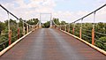 Regency Suspension Bridge spanning the Colorado River between Mills and San Saba counties

Cemeteries and churches[edit]
The Mills County Historical Commission details fifty-seven cemeteries in Mills County.[19] Early settlers buried their dead near their homes in post oak slabs fashioned into coffins by the local carpenter.[1]
| Name | Denomination | Town | Established | Retired | Notes |
|---|---|---|---|---|---|
| Center City Baptist Church | Baptish | Center City | |||
| Center City Methodist Church | Methodist | Center City | |||
| Methodist Church | Methodist | Ebony | Located near Regency | ||
| Baptist Church | Baptist | Ebony | |||
| Church of Christ | Church of Christ | Ebony | |||
| Assembly of God | Assembly of God | Goldthwaite | |||
| First Baptist Church | Baptish | Goldthwaite | |||
| First United Methodist Church | Methodist | Goldthwaite | |||
| St. Peters Catholic Church | Catholic | Goldthwaite | |||
| Jones Valley Baptist Church | Baptish | Jones Valley | |||
| Mount Olive Baptist Church | Baptist | July 28, 1899 | |||
| Mullin Church of Christ | Church of Christ | Mulliin | |||
| First Baptist Church | Baptist | Mullin | |||
| First United Methodist Church | Methodist | Mullin | |||
| Pompey Mountain Congregational Methodist Church | Methodist | Pompey Mountain | |||
| Pompey Mountain Missionary Baptist Church | Baptist | Pompey Mountain | |||
| Priddy Baptist Church | Baptist | Priddy | |||
| Zion Lutheran Church | Lutheran | Priddy | |||
| Regency Primitive Baptist Church | Baptist | Regency | |||
| Church of Christ | Church of Christ | Star | |||
| Star Baptist Church | Baptist | Star | |||
| Star United Methodist Church | Methodist | Star | |||
| Trigger Mountain Church | Baptist | Trigger Mountain |
Economy and industry[edit]
| 2019 Gross Domestic Product (GDP) | $179.40 M |
| 2020 Labor Force | 1,889 |
| 2020 Unemployment Rate | 4.10% |
The natural resources of pre-Mills county in Brown, Comanche, Hamilton, and Lampasas counties offered good support for early farming and ranching, yet most of the early settlers made their living by hunting.[7][1] Game provided food and pelts were often sent to Houston to sell.[1] One report from 1957 identifies only nineteen percent of the land can be tilled, placing an emphasis on grazing land.[5] The county has historically sustained itself through farming and ranching operations; in the early days, livestock served as the backbone of economy with sheep and goats taking its place later.[1] By 1890, there were 680 farms and ranches in the county, consisting of 142,299 acres, with 25,000 head of of cattle and 23,000 sheep.[21] Agricultural extension services started in Mills County around 1914.[1]
Mineral resources in the county are minimal: a small vein of coal was discovered near Ebony around 1950, and Weston No. 1 Well, located in the Rock Springs Community, produced very little gas and oil.[1] Much later, in 1982, oil made another appearance, leading to 28,122 barrels, yet by 1990, oil production ceased.[21]
Agritourism, including recreational hunting and fishing, supplements the economy.[22][23]
Farming and ranching[edit]
The cattle industry traces it beginnings to the first herd of long-horn cattle that arrived in Mills County in 1865, brought by J.H. Flower, which was followed shortly after by a huge herd purchased by John Williams.[4] The yearling sale at Williams Ranch attracted buyers from Kansas or the Indian Territory.[1] Cattle roamed the open range before settlers started fencing their land in the mid 1860s.[4] Barbed wire arrived in 1875 and by 1879 was widely available in Texas.[4][8] Land owners often fenced in areas they did not own that sometimes included public water sources for livestock, which led to a fence-cutting epidemic in the mid 1880s, leading to legislation forbidding it.[1] A severe drought in 1886 and 1887 led to cattle and horse deaths; whole herds of cattle left the country looking for water, and their owners sometime spent days hunting for them.[1] Some ranchers drove the herds to other parts of Texas to find water.[1]
Most of the early pioneers brought sheep when they arrived.[4] Owners clipped wool by hand and sent the fiber by wagon train to be sold in Houston.[4] The first local to have a sizable sheep herd was Eli Fairman, known as "Sheepman" Fairman.[4] Sheep and goats are credited with improving the economy of Mills County more than cattle, largely due to stable prices and the county having optimal conditions for raising them.[4] For years, Mills County ranked second in the state for wool and mohair production.[4] As of 1976, Mills County ranked highest in the state for lamb feeding operations.[4] Turkey and egg production were also once leading businesses in the county.[1][4] Hogs were once raised county-wide for meat.[5]
The cattle industry, from the beginning, has exhibited wild swings in prices in response to many factors, yet it remains a mainstay industry in Mills County.[4] Early cattle trade in Mills County relied on the Fort Worth Stockyards for selling, but the local auction ring effected higher prices through bidding, rather than waiting to receive an offer from a buyer who came to visit a rancher's stock .[4] Robert Briley started the first local auction that changed hands many times to become the Mills County Livestock Commission of Goldthwaite.[4] Later to be called the Mills County Commission Company, at one time it was the largest sheep and goat sale in the world.[1] An industry related to livestock buying and selling was the trucking business, which started before local auctions.[4] Early trucking, which only required a license and an railroad permit, was pioneered by Everett Holland and Lindsay Kettle from Mullin and Slim Hurst from Star.[4]
The first farmer in pre-Mills county used three basic tools: a walking turning plow, a walking planter, and a walking cultivator.[1]

By 1864, settlers started growing and harvesting cotton—the first bale of cotton was picked by W.F. Brown and ginned in Comanche.[4][1] By 1910, cotton acreage had ballooned to 46,000; it was the main crop from 1887 through 1917.[1][21] As the land was turned over to cotton, the cattle business shifted into western Texas.[1] Families worked together during cotton picking time to collect bales that would be taken to town to sell.[4] World War I disrupted the economy and effected crop diversification in Mills County, leading to a decline in cotton production.[1][21] Cotton acreage reached a low of 2,078 in 1959, exacerbated by the boll weevil.[5][21] Wise farmers and ranchers learned that a mix of crops and livestock kept them immune to complete failure.[1] By 1930, the county featured 32,000 acres of cotton, 21,300 head of cattle, 68,000 goats (many raised for mohair), 78,000 sheep, and 67,000 chickens.[21] The Great Depression signaled a general decline in Mills County farming (and overall population), leading to an upswing in mohair goats and sheep, as well as farm consolidations.[21] Starting in the 1970s and early 1980s, the county gained a number of manufacturing companies; by 1982, there were eight manufacturers employing one-hundred people.[21]
By around 1912, most families owned a small amount of stock and farmed small grain as a necessity.[1] At about the same time, steam threshers hit the market in Mills County.[1] Before then, farmers relied on horse-powered threshers.[1] Threshing was typically part of a community effort that included neighbors who hauled the grain to the barn and women that helped cook meals.[4] A crew consisted of an engine man, fireman, separator man, sack holders, pitchders, and grain and water wagon drivers.[1] Steam threshing crews could be "dependent" or "independent," which classified whether the wife of the crop's owner had to supply meals.[1] Most of the later crews were "independent," which meant they had their own cook shack.[1][4] During this time, around ten threshing crews worked the summer months in Mills County.[1] Combines appeared suddenly in Mills County, pushing out not only threshing machines but also reapers by 1939.[1]
Pecan harvesting is also a thriving industry, partly accelerated by the invention of the pecan shaker by O.L. Sides and his sons, W.L. and C.N. Sides.[4] In fact, pecans are credited as one of most lucrative crops in the early days of Mills County, fetching about four cents per pound.[1] Pecan crops were typically sold at markets in Houston.[1] In 1905, one Mills County citizen reported earnings of $49.10 from a single tree.[1] By 1929, pecan production had developed into a solid industry mostly in the southern part of the county and became a recognized center for development of new varieties.[1] 174,637 bushels of improved pecans were harvested in 1950, and in 1954 statistics reported 58,092 pecan trees and 385,792 pounds of pecans.[1]
The 1920s brought prosperity to Mills County, yet the booming oil business, launched by the automobile, lured many Mills County citizens, who left the county for better pay.[4] The Great Depression devestated the county, just as it did the rest of the country.[4] A product of the crashed economy, hoboes came into Goldthwaite on the train and lived in crude shelters near the tracks.[4] Depression relief programs provided by the U.S. Government were headquartered in the courthouse with E.B. Gilliam as administrator, yet Mills County's needs were not as severe as other counties in Central Texas.[1] One form of recovery that helped Mills County was the Agriculture Adjustment Act.[4]
Truck farming also had its day in Mills County: one successful operation was Riverside Farm, owned by J.J. Cockrell near the Colorado River, which once had one hundred acres cultivated in a variety of fruits and a one-hundred tree pecan orchard.[1]
In 1925, J.L. Corts established the first dairy about three miles southwest Goldthwaite called the "Regular Diary Farm.[1] The first Mills County cheese factory opened in Goldthwaite in 1928.[1] Also around this time, cold storage developed as both a stand-alone industry and also became a means to enhance other industries such as poultry.[1]
Renewable energy[edit]
There are currently three wind energy projects operating in Mills County that feature a total of 236 turbines that deliver an estimated 616 MW of power. [24] A fourth project, Castle Gap Wind, will add 197 MW of power capacity [though part of the project is in Lampasas County].[25]
Law and government[edit]
Mills County's governing body is a commissioner's court operating under Dillon's Rule, consisting of a county judge and four commissioners.[20]
| Name | Date Elected |
|---|---|
| Grundy, J.P. | 11/6/1888 |
| Head, J.B. | 11/4/1890 |
| Mohler, J.A. | 11/8/1892 |
| Logan, A.V. | 11/6/1894 |
| Logan, A.V. | 11/3/1896 |
| Dalton, G.H. | 11/8/1898 |
| Dalton, G.H. | 11/6/1900 |
| Patterson, L.E. | 11/4/1902 |
| Patterson, L.E. | 11/8/1904 |
| Patterson, L.E. | 11/6/1906 |
| Patterson, L.E. | 11/3/1908 |
| Allen, S.H. | 11/8/1910 |
| Allen, S.H. | 11/5/1912 |
| Dalton, G.H. | 11/3/1914 |
| Weaver, A.B. | 11/7/1916 |
| Weaver, Robert | 11/5/1918 |
| Patterson, L.E. | 11/2/1920 |
| Patterson, L.E. | 11/7/1922 |
| Patterson, L.E. | 11/4/1924 |
| Patterson, L.E. | 11/2/1926 |
| Patterson, L.E. | 11/6/1928 |
| Simpson, Roy | 11/4/1930 |
| Patterson, L.E. | 11/8/1932 |
| Gerald, R.J. | 11/8/1938 |
| Gerald, R.J. | 11/5/1940 |
| Patterson, John | 11/3/1942 |
| Patterson, John L. | 11/7/1944 |
| Patterson, John L. | 11/5/1946 |
| Porter, L.B. | 11/2/1948 |
| Porter, L.B. | 11/7/1950 |
| Patterson, John L. | 11/4/1952 |
| Patterson, John L. | 11/2/1954 |
| Yarborough, W.G. | 11/4/1958 |
| Egger, Cecil | 11/14/1960 |
| Egger, Cecil | 11/6/1962 |
| Egger, Cecil | 11/8/1966 |
| Egger, Cecil | 11/3/1970 |
| Faulkner, H.S. | 11/5/1974 |
| Ledbetter, J.W. | 11/7/1978 |
| Johnson, Wallace | 11/2/1982 |
| Johnson, Wallace | 11/4/1986 |
| Johnson, Wallace | 11/6/1990 |
| Wright, Randy | 11/8/1994 |
| Name | Precinct | Date Elected | Notes |
|---|---|---|---|
| Roach, Matt | 1 | 11/6/1888 | |
| Patterson, A.V. | 2 | 11/6/1888 | |
| Dalton, G.H. | 3 | 11/6/1888 | |
| Cooke, S.L. | 4 | 11/6/1888 | |
| Clements, Phil W. | 1 | 11/4/1890 | |
| Patterson, A.V. | 2 | 11/4/1890 | |
| Dalton, G.H. | 3 | 11/4/1890 | |
| Cooke, S.L. | 4 | 11/4/1890 | |
| Ashley, D.C. | 1 | 11/8/1892 | |
| Fletcher, W.H. | 2 | 11/8/1892 | |
| Belew, W.M. | 3 | 11/8/1982 | |
| Cooke, S.L. | 4 | 11/8/1892 | |
| Whitaker, Geo. | 1 | 11/6/1894 | |
| Fletcher, W.H. | 2 | 11/6/1894 | |
| Dalton, G.H. | 3 | 11/6/1894 | |
| Harvey, L.F. | 4 | 11/6/1894 | |
| Curry, P.E. | 1 | 11/3/1896 | |
| Head, J.B. | 2 | 11/3/1896 | |
| Sharp, R.B. | 3 | 11/3/1896 | |
| Harvey, L.F. | 4 | 11/3/1896 | |
| Roach, Matt | 1 | 11/8/1898 | |
| Head, J.B. | 2 | 11/8/1898 | |
| Boles, J. | 3 | 11/8/1898 | |
| Mason, W.J. | 4 | 11/8/1898 | |
| Humphries, M.C. | 1 | 11/6/1900 | |
| Patterson, A.V. | 2 | 11/6/1900 | |
| Fisher, J.L. | 3 | 11/6/1900 | |
| Nelson, Walter | 4 | 11/6/1900 | |
| Humphries, M.C. | 1 | 11/4/1902 | |
| Jones, J.F. | 2 | 11/4/1902 | |
| Henry, Hugh | 3 | 11/4/1902 | |
| Cooke, S.L. | 4 | 11/4/1902 | |
| Humphries, M.C. | 1 | 11/8/1904 | |
| Jones, J.F. | 2 | 11/8/1904 | |
| Henry, Hugh | 3 | 11/8/1904 | |
| Cook, S.L. | 4 | 11/8/1904 | |
| Humphries, M.C. | 1 | 11/6/1906 | |
| Jones, J.F. | 2 | 11/6/1906 | |
| Fletcher, J.A. | 3 | 11/6/1906 | |
| Cooke, S.L. | 4 | 11/6/1906 | |
| Berry, J.D. | 1 | 11/3/1908 | |
| Mason, J.W. | 2 | 11/3/1908 | |
| Renfro, J.B. | 3 | 11/3/1908 | |
| Nelson, W.H. | 4 | 11/3/1908 | |
| Hines, M.H. | 1 | 11/8/1910 | |
| Mason, J.W. | 2 | 11/8/1910 | |
| Renfro, J.B. | 3 | 11/8/1910 | |
| Nelson, W.H. | 4 | 11/8/1910 | |
| Hines, M.H. | 1 | 11/5/1912 | |
| Carter J.R. | 2 | 11/5/1912 | |
| Swindle, R.F. | 3 | 11/5/1912 | |
| Haynes, Reide M. | 4 | 11/5/1912 | |
| Karnes, A.D. | 1 | 11/7/1916 | |
| Henderson, J.F. | 2 | 11/7/1916 | |
| Hamilton, D.A. | 3 | 11/7/1916 | |
| Griffin, E.J. | 4 | 11/7/1916 | |
| Burnham, L.B. | 1 | 11/2/1920 | |
| Head, C.A. | 2 | 11/2/1920 | |
| Johnson, W.C. | 3 | 11/2/1920 | |
| Bledsoe, J.T. | 4 | 11/2/1920 | |
| Burnham, L.B. | 1 | 11/7/1922 | |
| Head, C.A. | 2 | 11/7/1922 | |
| Renfro, J.B. | 3 | 11/7/1922 | |
| Lowe, Jesse | 4 | 11/7/1922 | |
| Burnham, L.B. | 1 | 11/4/1924 | |
| Biddle, W.M. | 2 | 11/4/1924 | |
| Johnson, W.C. | 3 | 11/4/1924 | |
| Lowe, Jesse | 4 | 11/4/1924 | |
| Burnham, L.B. | 1 | 11/2/1926 | |
| Biddle, W.M. | 2 | 11/2/1926 | |
| Renfro, J.B. | 3 | 11/2/1926 | |
| Lowe, Jesse | 4 | 11/2/1926 | |
| Burnham, L.B. | 1 | 11/4/1930 | |
| Biddle, W.M. | 2 | 11/4/1930 | |
| Duren, E.A. | 3 | 11/4/1930 | |
| Burnett, J.H. | 4 | 11/4/1930 | |
| Burnham, L.B. | 1 | 11/8/1932 | |
| Hamilton, J.A. | 2 | 11/8/1932 | |
| McCurry, T. | 3 | 11/8/1932 | |
| Burnett, J.H. | 4 | 11/8/1932 | |
| Burnham, L.B. | 1 | 11/6/1934 | |
| Hamilton, J.A. | 2 | 11/6/1934 | |
| McCurry, T. | 3 | 11/6/1934 | |
| Egger, J.G. | 4 | 11/6/1934 | |
| Shaw, O.H. | 1 | 11/8/1938 | |
| Hamilton, J.A. | 2 | 11/8/1938 | |
| Barker, W.L. | 3 | 11/8/1938 | |
| Egger, J.G. | 4 | 11/8/1938 | |
| Tullos, J.Y. | 1 | 11/3/1942 | |
| Hamilton, J.A. | 2 | 11/3/1942 | |
| McCurry, T. | 3 | 11/3/1942 | |
| Roberts, S.A. | 4 | 11/3/1942 | |
| Tullos, J.Y. | 1 | 11/7/1944 | |
| Hamilton, J.A. | 2 | 11/7/1944 | |
| Henry, K.B. | 3 | 11/7/1944 | |
| Davis, J.F. | 4 | 11/7/1944 | |
| Tullos, J.Y. | 1 | 11/5/1946 | |
| Wall, Fred V. | 2 | 11/5/1946 | |
| 3 | 11/5/1946 | ||
| 4 | 11/5/1946 | ||
| Tullos, J.Y. | 1 | 11/2/1948 | |
| Wall, Fred V. | 2 | 11/2/1948 | |
| Henry, K.B. | 3 | 11/2/1948 | |
| Davis, J.F. | 4 | 11/2/1948 | |
| Tullos, J.Y. | 1 | 11/7/1950 | |
| Wall, Fred V. | 2 | 11/7/1950 | |
| Henry, K.B. | 3 | 11/7/1950 | |
| Davis, J.F. | 4 | 11/7/1950 | |
| Tullos, J.Y. | 1 | 11/4/1952 | |
| Wall, Fred V. | 2 | 11/4/1952 | |
| Downey, Albert | 3 | 11/4/1952 | |
| Egger, Cecil | 4 | 11/4/1952 | |
| Shaw, O.H. | 1 | 11/2/1954 | |
| Wall, Fred V. | 2 | 11/5/1954 | |
| Lee, W.T. | 3 | 11/2/1954 | |
| Egger, Cecil | 4 | 11/2/1954 | |
| Shaw, O.H. | 1 | 11/6/1956 | |
| Shaw, Kenneth H. | 1 | 11/9/1959 | |
| Lee, W.T. (Son) | 3 | 11/6/1956 | |
| Wall Fred V. | 2 | 11/4/1958 | |
| Brooks, H.G. | 4 | 11/4/1958 | |
| Rudd, Guy | 1 | 11/8/1960 | |
| Wall, Fred V. | 2 | 11/6/1962 | |
| Lindsey, W.R. | 3 | 11/8/1960 | |
| Brooks, H.G. | 4 | 11/6/1962 | |
| Rudd, Guy | 1 | 11/2/1964 | |
| Lindsey, W.R. | 3 | 11/2/1964 | |
| Rowlett, A.R. | 4 | Unexpired term | |
| Wall, Fred V. | 2 | 11/8/1966 | |
| Rowlett, A.R. | 4 | 11/8/1966 | |
| Roberts, Burthal | 1 | 11/5/1968 | |
| Lindsey, Ray | 3 | 11/5/1968 | |
| Wall, Fred V. | 2 | 11/3/1970 | |
| Rowlett, A.R. | 4 | 11/3/1970 | |
| Roberts, Burthal | 1 | 11/7/1972 | |
| Lindsey, Ray | 3 | 11/7/1972 | |
| Watson, Lewis D. | 2 | 11/5/1974 | |
| Jernigan, Hawley | 4 | 11/5/1974 | |
| Roberts, Burthal | 1 | 11/2/1976 | |
| Crawford, W.G. | 3 | 11/2/1976 | |
| Watson, Lewis D. | 2 | 11/7/1978 | |
| Jernigan, Hawley | 4 | 11/7/1978 | |
| Daniel, Floyd | 1 | 11/4/1980 | |
| Crawford, William | 3 | 11/4/1980 | |
| Watson, Lewis | 2 | 11/2/1982 | |
| Jernigan, H.B. | 4 | 11/2/1984 | |
| Lindsay, Marvin | 1 | 11/6/1984 | |
| Schwartz, Lee Roy | 3 | 11/6/1984 | |
| Watson, Lewis | 2 | ||
| Thorne, Farrel | 4 | 11/4/1986 | |
| Lindsay, Marvin | 1 | 11/8/1988 | |
| Schwartz, Lee Roy | 3 | 11/8/1988 | |
| Parker, Bill | 2 | 11/6/1990 | |
| Griffin, Charles H. | 4 | 11/6/1990 | |
| Karnes, Joe | 1 | 11/3/1992 | |
| Schwartz, Lee Roy | 3 | 11/3/1992 | |
| Bunting, Carroll | 2 | 11/8/1994 | |
| Griffin, Charles H. | 4 | 3/8/1994 | Mrs. C.H. Griffin was appointed to her husband's unexpired term on 7/5/1994 following his death |
| Name | Date Elected |
|---|---|
| Whitaker, Geo. | 11/6/1888 |
| Cervles, J.R. | 11/4/1890 |
| Unknown | 11/8/1892 |
| Anderson, E.B. | 11/6/1884 |
| Anderson, E.B. | 11/3/1896 |
| Patterson, Lon | 11/8/1898 |
| Patterson, L.E. | 11/6/1900 |
| Pribble, A.T. | 11/4/1902 |
| Pribble, A.T. | 11/8/1904 |
| Pribble, A.T. | 11/6/1906 |
| Pribble, A.T. | 11/3/1908 |
| Woods, W.H. | 11/8/1910 |
| Unknown | 11/5/1912 |
| Bowman, F.P. | 11/3/1914 |
| Bowman, F.P. | 11/7/1916 |
| Pribble, A.T. | 11/5/1918 |
| Pridbble, A.T. | 11/2/1920 |
| Pribble, A.T. | 11/7/1922 |
| Bowman, F.P. | 11/4/1924 |
| Pribble, A.T. | 11/2/1926 |
| Pribble, A.T. | 11/6/1928 |
| Pribble, A.T. | 11/4/1930 |
| Pribble, A.T. | 11/8/1932 |
| Pribble, A.M. | 11/8/1938 |
| Pribble, A.M. | 11/5/1940 |
| Pribble, Maston | 11/3/1942 |
| Pribble, A.T. | 11/7/1946 |
| Yarborough, W.G. | 11/5/1946 |
| Pribble, A.M. | 11/2/1948 |
| Pribble, A.M. | 11/7/1950 |
| Pribble, A.M. | 11/2/1954 |
| Pribble, A.M. | 11/4/1958 |
| Yarborough, W.G. | 11/6/1962 |
| Pribble, A.M. | 11/2/1964 |
| Pribble, A.M. | 11/5/1968 |
| Pribble, A.M. | 11/7/1972 |
| Pribble, A.M. | 11/2/1976 |
| Cockrum, J.C. | 11/4/1980 |
| Cockrum, J.C. | 11/8/1988 |
| Adams, Tommy | 11/3/1992 |
| Name | Date Elected |
|---|---|
| Cunningham, G.W. | 11/6/1888 |
| Cunningham, G.W. | 11/4/1890 |
| Geeslin, B.L. | 11/8/1892 |
| Geeslin, B.J., Jr. | 11/6/1894 |
| Geeslin, B.F. | 11/3/1896 |
| Welch, W.G. | 11/8/1898 |
| Welch, W.G. | 11/6/1900 |
| Atkinson, R.J. | 11/4/1902 |
| Atkinson, R.J. | 11/8/1904 |
| Ezzell, H.C. | 11/6/1906 |
| Ezzell, H.C. | 11/3/1908 |
| Priddy, E.O. | 11/8/1910 |
| Priddy, E.O. | 11/5/1912 |
| Burnett, John H. | 11/3/1914 |
| Burnett, J.H. | 11/7/1916 |
| Evans, J. Everett | 11/5/1918 |
| Evans, J. Everett | 11/2/1920 |
| Karnes, A.D. | 11/7/1922 |
| Karnes, A.D. | 11/4/1924 |
| Bledsoe, Carl D. | 11/2/1926 |
| Bledsoe, Carl D. | 11/6/1928 |
| Bledsoe, Carl D. | 11/4/1930 |
| Bledsoe, Carl D. | 11/8/1932 |
| Harris, J.H. | 11/6/1934 |
| Harris, J.H. | 11/8/1938 |
| Harris, J.H. | 11/5/1940 |
| Harris, J.H. | 11/3/1942 |
| Reynolds, F.D. | 11/7/1944 |
| Mahan, W.L. | 11/5/1946 |
| Mahan, W.L. | 11/2/1948 |
| Stubblefield, C.F. | 11/7/1950 |
| Stubblefield, C.F. | 11/6/1956 |
| Stubblefield, C.F. | 11/8/1960 |
| Brooks, Horace | 11/2/1964 |
| Brooks, Horace G. | 11/5/1968 |
| Brooks, Horace | 11/7/1972 |
| Brooks, Horace | 11/2/1976 |
| Wetterman, Ron | 11/4/1980 |
| Casbeer, Mack | 11/6/1984 |
| Carr, Glen | 11/8/1988 |
| Carr, Glen | 11/3/1992 |
Education[edit]
Early settlers taught their children the rudiments of reading, writing, and arithmetic at home when time allowed and within the limited boundaries of what they knew.[4] The first schools were held in the summertime under brush arbors, and teachers' meager pay was supplemented by gifts of provisions and free rent.[4] Attendance was poor due to the long distances that students had to travel.[4] Taught self-reliance and independence at home, lots of students defied the direction of teachers.[4] One of the early school teachers before Mills County was Phil H. Clements, who was teaching in 1878 after moving to Williams Ranch.[1] The concept of grades did not exist in the early days: students were classified according to reading level, e.g. second reader.[4] Often older, advanced students were called upon to teacher their juniors.[5]
School buildings started appearing in the 1860s and early 1870s, which were constructed by local men of logs with dirt floors, appointed with split-log benches and fireplaces, which a few years later were replaced by wood stoves.[4][5] Eventually log schools evolved into lumber-based buildings as material became available.[5] Schools usually had one room that had partitions made of panels or curtains for classrooms.[4] Books were donated by parents.[5] Most early schools had a tower with a bell, which rang out to announce the start of the school day.[4] Most also had a stage with a curtain made of advertising squares promoting local merchants, along with artistic embellishments, which was a source of community pride.[4] State support of pre-Mills County schools was minimal in the early days: for instance, Williams Ranch received ninety-nine dollars in 1878.[1] Students brought simple lunches in lard buckets, usually consisting of leftover bisquits.[4] In the early days, only Goldthwaite, Mullin, Priddy, and Star offered high school diplomas.[4]
An important order of business at the first meeting of the Mills County Commissioner's Court on October 12, 1887, was to incorporate schools that existed at the time into the a new county system educational system, including establishing local school taxes.[5]
| Brown County | Hamilton County | Lampasas County |
|---|---|---|
| "Union District at Goldthwaite" | District No. 35: Long Branch | District No. 40: Big Valley |
| William Ranch at Williams Ranch | District No. 46: Payne Gap | District No. 31: Big Valley |
| William Ranch at William Ranch (Black) | District No. 36: Center City | District No. 35: Kelley |
| Rock Springs at Rock Springs | District No. 39: Pleasant Grove | |
| Browns Creek on North Brown Creek | District No. 38 South Bennett | |
| Pompey Mountain near Pompey Mountain | District No. 37: North Bennett | |
| Ewing on Bayou | ||
| Williams at Mouth of Blanket Creek | ||
| Blanket Springs on Blanket Creek | ||
| Pleasant Ridge west of Blanket Creek | ||
| Cold Spring on Colorado River | ||
| Jones Valley on Colorado River | ||
| Hanna Velley on Colorado River | ||
| Buffalo Creek on Colorado River | ||
| Pompey Creek on Pompey Creek |
In 1900, Mr. and Mrs. T.W. Hatcher organized the Mills County Institute, also known as Hatcher University, in Goldthwaite on Fisher Street. It closed in 1907.[1]
By 1910, there were fifty-two public schools in Mills County with sixty-five teachers, and by 1976, there were eighty-one schools.[4]
In 1907, the "Self Culture Club" opened the first community library in the M.L. Brown Drug Store.[1] Miss Alline Howell, a teacher at the Rye Valley School, gathered community support to open the first county school library in 1915.[1] Its first collection of books were purchased as a lot from Farm and Ranch Magazine.[1]
During the 1930s, with teachers desperate for jobs, school boards were able to make strenuous demands of teachers, often requiring them to live in the community where they taught, agree to leave the community only one weekend per month, participate in various community events, and sometimes agree to not marry.[4]
The Star School building, erected in 1940, is the only school in the county to be built by the W.P.A.[4]
Today Mills County has four consolidated schools: Goldthwaite, Mullin, and Priddy [source included Star, which consolidated with Goldthwaite Consolidated ISD on July 1, 2014[29]].[4]
Recreation[edit]
The early county residents enjoyed a number of diversions, including dancing, attending movies, running horse races, going to town on Saturdays, and drinking at the saloons.[4][1] The first Mills County fairgrounds, located on the south side of Goldthwaite to the east of Livestock Commission Company, had a number of features, including a race track, baseball and football fields, an exhibition building, a band and dance platform, and sometimes a skating rink.[4] It also hosted a carnival.[4] All Goldthwaite football games were held at the football field at the fairgrounds—without bleachers–until a stadium was built near the school in the late 1930s.[4] A special buffalo bar-b-que organized by a number of local businessman in [1947 or 1948] welcomed Lyndon Baines Johnson, who arrived by helicopter.[4] The circus, hosted in Goldthwaite, also attracted residents from across the county.[4] Another regular diversion for county residents was the medicine show, held in Goldthwaite, in which proprietors put on an entertaining show designed to sell nostrums.[4] In the 1920s, Lake Merrit attracted many Mills County residents who camped and swimmed there.[4]
By the early 1890s, large game such as bear, panther, and jaguar had been evacuated from the county, leaving hunters smaller game such as bobcat, fox, wolf, coon, and possums.[1] Many early hunters used hounds to trail prey.[1] Game was the only substantive food for early settlers; deer, however, served various needs: in many households, they were the main meat and they sold antler and skins.[1]
Goldthwaite is home to the official Texas Sate Championship Goat and BBQ Cook-off.[30]
Politics[edit]
The Populist Party was at its height in Mills County towards the end of the nineteenth century.[1]
A growing faction of prohibitionists started in the late nineteenth and early twentieth centuries, leading to a ban on alcohol in the Goldthwaite School District; in 1908, liquor ban went into effect for the whole county.[1]
| Year | Republican | Democratic | Third party | |||
|---|---|---|---|---|---|---|
| No. | % | No. | % | No. | % | |
| 2020 | 2,217 | 88.50% | 271 | 10.82% | 17 | 0.68% |
| 2016 | 1,951 | 86.90% | 243 | 10.82% | 51 | 2.27% |
| 2012 | 1,882 | 85.51% | 279 | 12.68% | 40 | 1.82% |
| 2008 | 1,753 | 80.52% | 398 | 18.28% | 26 | 1.19% |
| 2004 | 1,794 | 80.41% | 416 | 18.65% | 21 | 0.94% |
| 2000 | 1,738 | 75.11% | 548 | 23.68% | 28 | 1.21% |
| 1996 | 1,044 | 51.35% | 748 | 36.79% | 241 | 11.85% |
| 1992 | 702 | 35.28% | 753 | 37.84% | 535 | 26.88% |
| 1988 | 1,043 | 55.24% | 842 | 44.60% | 3 | 0.16% |
| 1984 | 1,262 | 64.39% | 688 | 35.10% | 10 | 0.51% |
| 1980 | 985 | 47.84% | 1,028 | 49.93% | 46 | 2.23% |
| 1976 | 684 | 40.00% | 1,012 | 59.18% | 14 | 0.82% |
| 1972 | 1,089 | 73.43% | 388 | 26.16% | 6 | 0.40% |
| 1968 | 645 | 38.79% | 722 | 43.42% | 296 | 17.80% |
| 1964 | 495 | 28.73% | 1,228 | 71.27% | 0 | 0.00% |
| 1960 | 1,012 | 53.63% | 869 | 46.05% | 6 | 0.32% |
| 1956 | 912 | 55.34% | 735 | 44.60% | 1 | 0.06% |
| 1952 | 1,089 | 55.39% | 875 | 44.51% | 2 | 0.10% |
| 1948 | 205 | 14.46% | 1,135 | 80.04% | 78 | 5.50% |
| 1944 | 172 | 9.47% | 1,428 | 78.59% | 217 | 11.94% |
| 1940 | 287 | 14.75% | 1,658 | 85.20% | 1 | 0.05% |
| 1936 | 165 | 14.10% | 1,005 | 85.90% | 0 | 0.00% |
| 1932 | 133 | 8.49% | 1,434 | 91.51% | 0 | 0.00% |
| 1928 | 774 | 63.65% | 442 | 36.35% | 0 | 0.00% |
| 1924 | 175 | 11.55% | 1,289 | 85.08% | 51 | 3.37% |
| 1920 | 247 | 20.57% | 669 | 55.70% | 285 | 23.73% |
| 1916 | 129 | 14.69% | 640 | 72.89% | 109 | 12.41% |
| 1912 | 92 | 10.03% | 573 | 62.49% | 252 | 27.48% |
Media[edit]
The first known newspaper, preceding the formation of Mills County, was the Rancho Rackett, which started around 1880 at Williams Ranch.[4] A broadside appeared in Goldthwaite, printed on a portable press by Lampasas resident"Calamity" Bonner, and is credited as the first paper distributed in the town.[1] In the fall of 1885, W.H. Thompson started publishing a weekly,The Mountaineer.[1][32] The first profitable weekly newspaper, The Mountain Eagle, was established by W.H. Thompson and R.M. Thompson in 1894.[1][4] The same year a weekly called The Mills County Advocate commenced publication.[1] In 1896, the The Mountain Eagle was sold, and its name changed to The Goldthwaite Eagle.[4] The Mullin Enterprise, which began in 1902,[33] merged with The Eagle in 1950.[4]
Mills County is part of the Waco/Temple/Killeen (Central Texas) DMA. Local media outlets include: KCEN-TV, KWTX-TV, KXXV-TV, KDYW, KWKT-TV and KNCT-TV. Two other television stations from the Abilene/Sweetwater/Brownwood DMA provide coverage for Mills County, KTAB-TV and KRBC-TV. KRNR FM 92.7, "Redneck Radio," currently broadcasts from Goldthwaite.[34] An earlier radio station broadcasted from The Goldthwaite Eagle editorial offices before moving to Brownwood and broadcasting under the call letters KGKB.[4]
Transportation[edit]
Pioneers traveled through pre-Mills County by wagon pulled by ox, mule, or horse teams on primitive clearings through wooded areas or via crude trails that were often nearly impassable in wet conditions due to mud holes.[1] Rivers were forded, but some waterways had log bridges.[1] They went to Waco or Houston for supplies—a round trip to Waco took seven to ten days.[1] Freight wagons moved the same way loaded with hogs, wood, hides, pelts, and pecans to be traded for supplies, and they were sometimes followed by a herd of cattle.[1]
In 1901, before the Texas Highway Department was formed, county roads were maintained via a $3.00-per-person tax, known as the "road tax."[1] Instead of paying the tax, a person could work three days a week on the road or hire someone else to take his place.[1]
Major highways[edit]
Railroads[edit]
The railroad had a profound impact on the development of the county.[1] Prior to 1885, the railroad had announced its intentions to build a railway that would pass through Goldthwaite and Mullin,[35] and in 1885, tracks were laid through Goldthwaite, Pegtown, and Mullin, then onto Brownwood.[1] In 1885, the Santa Fe Railroad bypassed Williams Ranch and another booming town, Center City, and created two new towns, Goldthwaite and Mullin.[6] On September 2, 1885, two years before Mills County formed, a train operated by the Gulf, Colorado, and Santa Fe Railroad made a stop at Goldthwaite (then in Brown County), and on that day Thos. W. Jackson, Santa Fe Land Commissioner, begin auctioning lots that would be the foundation of the town.[4]
Mail[edit]
Before the postal service arrived in pre-Mills County in the late 1870s, mail was carried by travelers or cowboys from San Saba.[1] The earliest known postmaster in the area was James D. Williams at Williams Ranch, who was appointed on January 16, 1877.[1] Miss Dera Humphries is recognized as first woman mail carrier in Mills County, serving from 1921-1941.[1]
See also[edit]
- List of counties in Texas
- National Register of Historic Places listings in Mills County, Texas
- Recorded Texas Historic Landmarks in Mills County
External links[edit]
General[edit]
- Mills County from the Handbook of Texas Online
Economy and Industry[edit]
Education[edit]
- Goldthwaite Consolidated Independent School District
- Jennie Trent Dew Library
- Legacy Plaza - Texas Botanical Gardens, Native American Interpretive Center, and Goldthwaite Welcome Center
- Mullin ISD
- Payne Gap School History, 1887-1943
- Priddy Independent School District
Geography, topography, and natural features[edit]
- Wildlife District - Texas Parks & Wildlife
Cemeteries[edit]
- Mills County Cemeteries - Find-a-Grave
History[edit]
- Legislation Creating Mills County - Legislative Reference Library of Texas
- Mills County Historical Commission
- Mills County Historical Markers - Mills County Historical Commission
- Mills County Historical Museum
- Payne Gap Archeological Survey - Cooking Midden
- Philip Hathaway Clements - Father of Mills County
Climate[edit]
- Goldthwaite Climatology - National Weather Service, National Oceanic and Atmospheric Administration
- Mills County Drought Conditions - National Oceanic and Atmospheric Administration, National Integrated Drought Information System
Maps[edit]
- Mills County Map - Google Maps
Newspapers[edit]
Recreation[edit]
References[edit]
- ^ a b c d e f g h i j k l m n o p q r s t u v w x y z aa ab ac ad ae af ag ah ai aj ak al am an ao ap aq ar as at au av aw ax ay az ba bb bc bd be bf bg bh bi bj bk bl bm bn bo bp bq br bs bt bu bv bw bx by bz ca cb cc cd ce cf cg ch ci cj ck cl cm cn co cp cq cr cs ct cu cv cw cx cy cz da db dc dd de df dg dh di dj dk dl dm dn do Gatlin Bowles, Flora, ed. (1958). No Man's Land Becomes a County. Mills County Historical Society. OCLC 2666894.
- ^ "Mills County, Texas". United States Census Bureau. Retrieved February 23, 2021.
- ^ "Find a County". National Association of Counties. Retrieved 2011-06-07.
- ^ a b c d e f g h i j k l m n o p q r s t u v w x y z aa ab ac ad ae af ag ah ai aj ak al am an ao ap aq ar as at au av aw ax ay az ba bb bc bd be bf bg bh bi bj bk bl bm bn bo bp bq br bs bt bu bv bw bx by bz ca cb cc cd ce cf cg ch ci cj ck cl cm cn co cp cq cr cs ct cu cv cw cx cy cz Blackwell, Hartal Langford (1976). Mills County: the Way it Was. Mills County Historical Commission. OCLC 731220652.
- ^ a b c d e f g h i j k l m n o p q r s t u v w x Williams, Raymond Harper (1957). Sixty Years of Education in Mills County. OCLC 9459794.
- ^ a b c "Mills County Historical Commission". txmchc.genealogyvillage.com. Retrieved 2022-10-20.
- ^ a b c d e f g h i j k l m Cox, Ross J. (2005). The Texas Rangers & the San Saba Mob. R. Cox. OCLC 63148340.
- ^ a b c d e f g h McSwain, Ross (2008). See No Evil, Speak No Evil: a History of Mob Violence in the Texas Heartland, 1869-1904. San Angelo, TX: Shadetree Enterprises. OCLC 308648404.
- ^ "William Jenkins (1825-1866) - Find a Grave..." www.findagrave.com. Retrieved 2022-11-09.
- ^ a b c d e f g h i j k l m n o p q Mills County Memories. Goldthwaite, Texas: Mills County Historical Commission. 1994. OCLC 32618426.
- ^ "2010 Census Gazetteer Files". United States Census Bureau. August 22, 2012. Retrieved May 4, 2015.
- ^ a b c d e f Clower, Dennis F. (1980). Soil Survey of Brown and Mills Counties, Texas. United States Department of Agriculture, Soil Conservation Service, in Cooperation with Texas Agricultural Experiment Station.
- ^ "Texas Almanac: Population History of Counties from 1850–2010" (PDF). Texas Almanac. Retrieved November 14, 2022.
- ^ a b "US Census QuickFacts". Census.gov. Retrieved November 14, 2022.
- ^ "United States Census QuickFacts, Mills County, Texas". November 14, 2022. Retrieved November 14, 2022.
- ^ "Climate at a Glance | National Centers for Environmental Information (NCEI)". www.ncei.noaa.gov. Retrieved 2022-10-27.
- ^ "88 Year Weather Data Recorded in Goldthwaite, Mills County Texas, Retrieved from Weatherbase.com, Goldthwaite, Mills County, Texas". Weatherbase.com. Retrieved November 10, 2022.
- ^ Little, Carol Morris (1996). A Comprehensive Guide to Outdoor Sculpture in Texas. University of Texas Press. p. 237. ISBN 978-0-292-76036-3.
- ^ Mills County Texas Cemeteries. Mills County Historical Commission. 2002. OCLC 58425794.
- ^ a b "How much do you know about your county?". County Explorer. Retrieved 2022-11-14.
- ^ a b c d e f g h "Mills County was Carved from Four Area Counties". Mills County Visitor Guide 2021: 22. 2021.
- ^ Sutherland, Kylee (2022). "Predator Association Helps Wildlife". Mills County Hunting Guide.
- ^ "What is Agritourism?". 2021-22 Mills County Visitor Guide. 2021.
- ^ "Viewer | USWTDB". eerscmap.usgs.gov. Retrieved 2022-11-14.
- ^ "Castle Gap Wind". Swift Current Energy. Retrieved 2022-11-14.
- ^ "Power Generator Report". www.puc.texas.gov. Retrieved 2022-11-14.
- ^ "Power Generator Report". www.puc.texas.gov. Retrieved 2022-11-14.
- ^ "Power Generator Report". www.puc.texas.gov. Retrieved 2022-11-14.
- ^ "The Goldthwaite Eagle - June 4, 2014". 1318.newstogo.us. Retrieved 2022-11-12.
- ^ McMahan, Mike (2021). "Welcome Visitors!". Mills County Visitor Guide 2021.
- ^ Leip, David. "Dave Leip's Atlas of U.S. Presidential Elections". uselectionatlas.org. Retrieved 2018-07-27.
- ^ Humanities, National Endowment for the. "The mountaineer". Retrieved 2022-10-24.
- ^ Humanities, National Endowment for the. "The Mullin enterprise". Retrieved 2022-10-24.
- ^ "KRNR-FM 92.7 MHz - Goldthwaite, TX". radio-locator.com. Retrieved 2022-10-24.
- ^ Blackwell, Hartal Langford (1976). Mills County: the Way it Was. Mills County Historical Commission. OCLC 731220652.
Places adjacent to Sillyputty1967/sandbox | ||||||||||||||||
|---|---|---|---|---|---|---|---|---|---|---|---|---|---|---|---|---|
| ||||||||||||||||
Municipalities and communities of Mills County, Texas, United States | ||
|---|---|---|
| City |  | |
| Town | ||
| CDP | ||
| Other communities | ||
| Ghost towns | ||
| Footnotes | ‡This populated place also has portions in an adjacent county or counties | |
31°30′N 98°35′W / 31.50°N 98.59°W