
User talk:Aotearoa
Welcome!
Hello, Aotearoa, and welcome to Wikipedia! Thank you for your contributions. I hope you like the place and decide to stay. Here are a few good links for newcomers:
- The five pillars of Wikipedia
- How to edit a page
- Help pages
- Tutorial
- How to write a great article
- Manual of Style
I hope you enjoy editing here and being a Wikipedian! Please sign your name on talk pages using four tildes (~~~~); this will automatically produce your name and the date. If you need help, check out Wikipedia:Where to ask a question, ask me on my talk page, or place {{helpme}} on your talk page and someone will show up shortly to answer your questions. Again, welcome! —User:ACupOfCoffee@ 20:10, 5 February 2006 (UTC)
Polish money images[edit]
Please don't remove {{money}} - untagging images makes them auto-deletable.--Piotr Konieczny aka Prokonsul Piotrus Talk 16:46, 19 March 2006 (UTC)
- Podstawowa różnica między pl a en wiki jest że ta druga dopuszcza fair use. Dlatego też wizerunki pieniędzy mogą tu zostać. Bądź więc łaskaw się zrewertować.--Piotr Konieczny aka Prokonsul Piotrus Talk 18:03, 19 March 2006 (UTC)
- Powtórzę: to nie jest pl-wiki. Na pl-wiki nie stosujemy fair use, bo polskie prawo nie dopuszcza takiej formy 'obchodzenia' praw autorskich, ale na en-wiki fair use jest dopuszczalne (choć nie rekomendowane). Zacytuję: fair use dopuszcza for the legal, non-licensed citation or incorporation of copyrighted material in another author's work. Nie ma znaczenia jak bardzo restrykcyjne są prawa autorskie NBP - fair use pozwala nam użyć ich obrazów na en-wiki. Poza tym, od strony prodecuralnej najpierw powinno się przedystkutować kasowanie tagów a potem je wykonać - bo jak bot skasuje obrazki a zdecydujemy się, że jednak ja miałem rację, to będzie roboty kilka razy tyle niż jeśli ty masz rację.--Piotr Konieczny aka Prokonsul Piotrus Talk 16:47, 20 March 2006 (UTC)
- Dzieki - to nie jest czepianie, tylko wspolna praca :) Mysle, ze obecne rozwiazanie jest ok.--Piotr Konieczny aka Prokonsul Piotrus Talk 18:48, 20 March 2006 (UTC)
- Zerknij na Wikipedia_talk:Polish_Wikipedians'_notice_board#Polish_money.2C_NBP_and_fair_use - ciekawy argument się pojawił. A tak ogólnie to zapraszam na nasz noticeboard - warto go 'watchować' :) --Piotr Konieczny aka Prokonsul Piotrus Talk 04:07, 23 March 2006 (UTC)
- Dzieki - to nie jest czepianie, tylko wspolna praca :) Mysle, ze obecne rozwiazanie jest ok.--Piotr Konieczny aka Prokonsul Piotrus Talk 18:48, 20 March 2006 (UTC)
- Powtórzę: to nie jest pl-wiki. Na pl-wiki nie stosujemy fair use, bo polskie prawo nie dopuszcza takiej formy 'obchodzenia' praw autorskich, ale na en-wiki fair use jest dopuszczalne (choć nie rekomendowane). Zacytuję: fair use dopuszcza for the legal, non-licensed citation or incorporation of copyrighted material in another author's work. Nie ma znaczenia jak bardzo restrykcyjne są prawa autorskie NBP - fair use pozwala nam użyć ich obrazów na en-wiki. Poza tym, od strony prodecuralnej najpierw powinno się przedystkutować kasowanie tagów a potem je wykonać - bo jak bot skasuje obrazki a zdecydujemy się, że jednak ja miałem rację, to będzie roboty kilka razy tyle niż jeśli ty masz rację.--Piotr Konieczny aka Prokonsul Piotrus Talk 16:47, 20 March 2006 (UTC)
- Zerknij na Wikipedia_talk:Polish_Wikipedians'_notice_board#Polish_money.2C_NBP_and_fair_use, kolejny argument. Mieciu K 21:07, 30 March 2006 (UTC)
San Marino map[edit]
Cześć! I don't want to be cheeky, but I just saw that there's a misspelling on your San Marino map. Instead of Castello di Featano it should read Castello di Faetano, i.e. the a and the e should swap places. Regards, nepTune 17:48, 15 May 2006 (UTC)
On the map of San Marino, Chiesanouva needs to be correctly spelled as Chiesanuova. Regards, John Wayah — Preceding unsigned comment added by 98.18.196.69 (talk) 15:09, 26 May 2012 (UTC)
Naypyidaw[edit]
Sorry, but I just keep noticing you revert the MLC transcription of the Burmese name of "Naypyidaw". The spelling is meant to awkward, because the MLCTS system emphasises orthography over pronunciation. "Nay pyi daw", as you edited, is not the correct transcription. Hintha 07:31, 12 July 2006 (UTC)
Stop Changing the Land Area of POLAND[edit]
I agree with someone who posted the area of 312685 sq km earlier today. I went to see both sources mentioned by you User:Aotearoa as well as the TABLICE by Central Statistical Office of Poland (see references; Page 1)) and I have to conclude that we should consider the land are of Poland as 312685 sq km! Did you ever see any country's area posted in any media that would include external sea or ocean area! Please take a look around the internet and you will never see such things posted anywhere! Even though the area of Poland including the external sea is 322575 sq km, the land area including inland sea area in only 312685 sq km and this number should be posted to not confuse other users! Please come to Talk:Poland section to discuss this further. Once again, please do not confuse readers with your version of information (322575 sq km). The Central Statistical Office posted the total land area of POLAND on many of their documents as 312685 sq km. Do not change the land area with your info! The area posted now, 312685 sq km, is the correct total land area referenced here by 3 sources and there are many more sources to support this fact out there! Thanks! --Thomaspca 20:13, 10 December 2006 (UTC)
I see that you continue to vandalize the English version of the introduction section of POLAND. The changes that you make do not make any sense, they confuse people, and they do not look good! I redesigned the Introduction part and the Culture section of POLAND and now they still look good but I am not sure for how long the sections will stay that way. Unfortunately, due to the constant vandalism by you and others, I decided that all of the improvements are not worth my valuable time that is why I wont do them anymore! DOWIDZENIA! --Thomaspca 19:51, 11 December 2006 (UTC)
[edit]
|
.svg)
-- Piotr Konieczny aka Prokonsul Piotrus | talk 06:54, 12 December 2006 (UTC)
Map of Melekeok, Palau[edit]
Hi there, I saw that you added a portion of a topographic map showing Melekoek, which is the new capital of Palau. Where did you find that map (URL)? Perhaps you have to show a larger piece of the original map to cover all of Melekeok State, since some of the villages (added by me today) don't show. Lake Ngardok doesn't seem to show either, but it would have to show on a map of such detail, covering almost 5 out of Melekeoks 28 km².--Ratzer 15:11, 28 January 2007 (UTC)
Response to my talk page[edit]
While I appreciate your concern and comments about my maps of the Powiaty of Poland, I must inform you that any mistakes are a direct reflection to the Polish government website that I obtained the maps from. Also, you claim that there are "50 mistakes" but you offer no examples. Suffice to say, I would appreciate it that, instead of criticism, next time you provide examples where there are mistakes that need to be addressed. Otherwise you are simply not contributing in good faith. Rarelibra 13:54, 5 February 2007 (UTC)
AfD nomination of Frolik Island[edit]

An editor has nominated Frolik Island, an article on which you have worked or that you created, for deletion. We appreciate your contributions, but the nominator doesn't believe that the article satisfies Wikipedia's criteria for inclusion and has explained why in his/her nomination (see also "What Wikipedia is not").
Your opinions on whether the article meets inclusion criteria and what should be done with the article are welcome; please participate in the discussion by adding your comments at Wikipedia:Articles for deletion/Frolik Island and please be sure to sign your comments with four tildes (~~~~).
You may also edit the article during the discussion to improve it but should not remove the articles for deletion template from the top of the article; such removal will not end the deletion debate. Thank you. BJBot (talk) 13:59, 29 January 2008 (UTC)
- Please don't move and replace with completely different content an article under deletion discussion as it makes things more complicated. I've now restored the latest version of Oroluk Island without the previous edit history. --Tikiwont (talk) 10:52, 5 February 2008 (UTC)
Tajik or Persian?[edit]
You have corrected just one instance of Persian to Tajik in the article Tajikistan. There are other instances in the same article and in a host of other Tajikistan-related articles. Please see the corresponding discussion section Tajik or Persian on Talk:Tajikistan. It would be great if you could deal systematically and authoritatively with the whole issue of "Tajik versus Persian" to ensure uniformity and consistency. I am not qualified to do this, but the problem is obviously there. Proper references to the correct usage should be supplied to prevent edit wars on this emotionally charged issue. --Zlerman (talk) 00:24, 18 June 2008 (UTC)
Netherlands Antilles[edit]
The websites are out of date. Here's one source. I'll see if I can't find something in the Amigoe archives as well. It was a big deal when it happened, because many of our Spanish speaking residents took it as an insult that of the four commonly spoken languages, Spanish was the only one that was not made official.Kww (talk) 15:55, 18 June 2008 (UTC)
- Bonaire Reporter coverage.
Kww (talk) 16:09, 18 June 2008 (UTC) - The Times coverage
Kww (talk) 16:14, 18 June 2008 (UTC) - Unesco report on the legislation
Kww (talk) 16:16, 18 June 2008 (UTC)
I can understand your confusion. I'll check with the Bonaire Reporter staff and see if they can find the actual text of the proclamation. I can do business with the government of Bonaire in English ... I file permit applications in English, land zoning applications in English, etc. That was not possible before March 2007. Since then, the answer I get is that they are required to accept my petitions in English, but they may only have the forms available in Dutch and Papiamentu. If I have the form translated and submit the translation, they always accept it. Anecdotally, I've heard of similar situations of Papiamentu speakers dealing with the government of Sint Maarten.
I think the text of the proclamation made everything official everywhere, but in practice, English isn't used much on Curacao and Bonaire, and Papiamentu isn't used on the northern islands.
Kww (talk) 17:04, 18 June 2008 (UTC)
The Editor's Barnstar

|
The Editor's Barnstar | |
| Thank you very much for your edit to Nepal in which you removed the long name and restored the short name. Kushal (talk) 14:22, 22 June 2008 (UTC) |
South Ossetia[edit]
Hey, nice map that you added. By why is it in Polish? This could be confusing to the average en.wiki reader. Khoikhoi 20:29, 16 August 2008 (UTC)
- Hmm, the only problem is that all the place names are in Polish. The spelling "Cchinwali" is used only in Polish, it is preferred that we use English as much as possible here. Since we do have an English map, perhaps it's best if we only use your map on pl.wiki until we find a suitable replacement. Khoikhoi 20:43, 16 August 2008 (UTC)
Somaliland map[edit]
Hi there. Please stop adding that homemade map to the Somaliland article. It is unreferenced and inaccurate, as it shows the Somaliland region of Somalia bordered by Somalia itself instead of the more easternly Maakhir or Puntland regions of Somalia. Unless the idea is to promote the notion that Somaliland is an independent country of its own rather than the northwestern region of Somalia that every single country and international organization know it to be, the map cannot stay. It is also redundant since there are already two other maps of Somaliland included only a few spaces up. Regards, Middayexpress (talk) 00:06, 31 October 2008 (UTC)
- I've taken a good look at the map you've created, and you're right: Somaliland is presented as a region of Somalia in it. I was for some odd reason under the impression that you showed Somaliland bordered by Somalia itself rather than other regions of Somalia. I sincerely apologize for this mischaracterization of your map and sloppy oversight on my part. The map, though indeed "homemade", is quite nice and, as it turns out, fairly accurate to boot. Again, apologies! Kind regards, Middayexpress (talk) 08:55, 1 November 2008 (UTC)
- Right again. The situation regarding the status of Sool and Sanaag vis-a-vis the Somaliland, Puntland, Maakhir and now so-called "Northland State" macro-regions of Somalia is constantly in flux. All seem to have a claim on these two micro-regions, so it's slightly conjectural as to which exact macro-region in particular "controls" them. I think the essential thing is to steer clear of any POV secessionist claims of an "independent" Somaliland, a problem which seems to regularly affect the Somaliland article. Your map thankfully avoids this pitfall, so it's a keeper IMO. Middayexpress (talk) 09:43, 1 November 2008 (UTC)
Hiri Motu (Offical Language)[edit]
I have endeavoured to locate specific legislation of Papua New Guinea designating Hiri Motu (and Tok Pisin and English) as official lanuages. There seems to be no such legislation! (Although it is widely believed that the three languages do have "offical" status - and many (unoffical) sources do state this). At least no specific law is indexed under the offical PNG legal website. There are however three mentions of the language in the PNG constitution that imply its having official status, and may even be taken as conferrring that status. I have added a footnote to this effect. --Soundofmusicals (talk) 08:43, 24 November 2008 (UTC)
Помогите мне с переводом карты (Help me please)[edit]
Здравствуйте! Обращаюсь к вам по-русски, так как у вас на странице написано, что вы знаете русский язык на начальном уровне. Пожалуйста, можете мне отправить PSD-файл от карты http://ru.wikipedia.org/wiki/Файл:Osetia_Południowa.png (Please send me PSD file from this file at http://ru.wikipedia.org/wiki/Файл:Osetia_Południowa.png). Я хочу перевести ее на русский язык (I like to translate this map into Russian). Спасибо (Thank you). -Alexander Nureyev (my personal page on Wikipedia RU - http://ru.wikipedia.org/wiki/Участник:Alexander_Nureyev) —Preceding unsigned comment added by 92.47.185.2 (talk) 15:37, 8 June 2009 (UTC)
Bolivia[edit]
I know your intentions are good however the thing is that the new Bolivian constitution of 2009 no longer mentions La Paz. You can read the constitution here [1] and explanations here [2]. The Constitution assigns the role of national capital to Sucre, La Paz is not indicated in the text. However, because the Palacio Quemado (Bolivian executive headquarters) is located in La Paz, it's going to become the de facto administrative capital, while Sucre became the official capital. So La Paz no longer has an official status, it is only a de facto capital city but per new constitution the only capital city is Sucre. Compromise would be to write "official capital" next to Sucre and "the seat of the Palacio Quemado" next to La Paz. --Avala (talk) 14:57, 11 June 2009 (UTC)
Dzienkuje[edit]
Great map for Hutt River. Thanks! Next time, add it to the article right away. Someone else apparently just discovered it and put it there...Seb az86556 (talk) 04:10, 20 July 2009 (UTC)
Reply To Message on Dhivehi Wikipedia[edit]
Hello, as you have asked for the dhivehi names for Laccadive Sea and for Maldive Islands here they are
- Laccadive Sea : Laccadive Kan'du - ލަކަޑިވް ކަނޑު
- Maldive Islands: Dhivehi Raajjeyge rah tha - ދިވެހިރާއްޖޭގެ ރަށްތައް
Regards... --Glacious (talk) 17:46, 1 August 2009 (UTC)
JAO[edit]
Hi there! I had to revert your addition to the Jewish Autonomous Oblast article again. The Charter of JAO was completely revised on November 7, 2008; any revisions prior to that are obsolete and should not be linked to (especially not next to the reference which cites the most recent revision, which is April 29, 2009). I was unable to find a link to a full text that is current. If you are more lucky, please simply add the link to the ru_url parameter of the {{RussiaBasicLawRef/yev}}.
I also removed the full text of Article 6.1 from the citation. This is per the WP:CITE#HOW guideline—we do not include the text of the source in the reference, we only include the data that help locate that source.
Anyway, if you have any questions, please feel free to drop me a note. Cheers,—Ëzhiki (Igels Hérissonovich Ïzhakoff-Amursky) • (yo?); 20:22, October 26, 2009 (UTC)
- Yup, this one will work great! I'll be adding it to the citation template shortly. Thanks for finding it! For some reason the only thing I was able to find on the official website was a .rar archive.—Ëzhiki (Igels Hérissonovich Ïzhakoff-Amursky) • (yo?); 20:35, October 26, 2009 (UTC)
Oroluk[edit]
Oroluk Island is not 0.49 km² in area. Look at the sat image, measure lenght and width, and do an approximative calculation of an elliptical area. There was a diskussion in the de-WP about the area of this island. I wanted the en-WP to have the correct area, too, but if you oppose, I don't insinst.--Ratzer (talk) 08:20, 18 January 2010 (UTC)
- Area 0,49 sq. km was in Atlas of Pohnpei ([3] – unfortunately death link now), and 0,5 sq. km is listed in Review of the Protected Areas System of Oceania. If you have published sources for area 0,15 sq. km, change it and add references. Aotearoa (talk) 12:50, 18 January 2010 (UTC)
- Wrong area figures may spread from one source to another and be very difficult to get rid of in the internet. Satellite images are also recognized as sources, and they are verifiable, even by estimate. The satellite image proves that the area of the islet cannot be 0.5 km², and that 0.15 km² is a good estimate of the real area. Just measure length and widht here and calculate the maximal area, a rectangle, and observe that the calculation of an elliptical area is a better estimate (the island is not a rectangle, but rounded at the edges).--Ratzer (talk) 07:13, 26 January 2010 (UTC)
- Hello,
- As you can see, despite the NPOV template, we're trying to keep the article as neutral as possible.
- By introducing your map that indicates the Perejil Island as a Spanish territory claimed by Morocco, you infringe the WP:NPOV policy, and you make the text's information contradictory to the one of the map.
- Btw, you infringe both the WP:3RR and the WP:NPOV, your changes will be reverted as long as the added map isn't neutral.
- If the problem on Commons got no solution because of your friend, who, as an admin, blocked me following your request while I was making some NPOV corrections on the maps, despite the fact that the NPOV must be respected on all WP content (quoting the WP:NPOV page: All Wikipedia articles and other encyclopedic content must be written from a neutral point of view), it will not be the case here.
- Thanks for your understanding.
- Omar-Toons (talk) 01:02, 17 July 2010 (UTC)
Problem z IPkiem[edit]
Cześć,
Prawdopodobnie trzeba zgłaszać takie sprawy do Wikipedia:Administrator intervention against vandalism, ale tam jest kilka założeń które trzeba spełnić. Pozdrowienia,
Kpjas (talk) 22:32, 17 December 2010 (UTC)
Problems with upload of File:Answer of Polish Ministry of Foreign Affairs.jpg[edit]
Thanks for uploading File:Answer of Polish Ministry of Foreign Affairs.jpg. You don't seem to have said where the image came from, who created it, or what the copyright status is. We require this information to verify that the image is legally usable on Wikipedia, and because most image licenses require giving credit to the image's creator.
To add this information, click on this link, then click the "Edit" tab at the top of the page and add the information to the image's description. If you need help, post your question on Wikipedia:Media copyright questions.
For more information on using images, see the following pages:
Thank you for your cooperation. --ImageTaggingBot (talk) 19:09, 19 January 2011 (UTC)
Request, map[edit]
Hello, Aotearoa! I see that you are quite experienced in map-making, and I therefore want to ask you if you could help me out a bit. I am currently working on improving the Queen Maud Land article (hopefully to GA/Good Article status). However, there exists no detailed map of Queen Maud Land on Wikipedia, other than those indicating its territorial extent. So, the reason I come to you, is simply because I saw this map [4], which you have made for the Australian Antarctic Territory. I don't know if you can do it, but what I want to ask you is wheter you could be able to create such a map for Queen Maud Land (if you are not particularly familiar with the territory, this Norwegian map [5] should help you to locate the various areas/stations). I understand completly if you for some reason don't want to do it, but as said, it would be very much appreciated and helpful if you could. Kind regards, – Bellatores (t.) 19:05, 11 July 2011 (UTC)
Per WP:BRD, if someone reverts your edit, you are then to take the issue to the Talk page of the article and build consensus for your change. You do not simply revert the reversion. You have not taken the issue of Portuguese at Equatorial Guinea to the talk page at List of sovereign states. Do not continue your edit war, try to build consensus. --Taivo (talk) 05:00, 29 July 2011 (UTC)
Polish recognition of NTC[edit]
O która stację Ci chodziło, gdy wspominałeś to na stronie o relacjach NTC? Boniek1988 (talk) 16:56, 29 August 2011 (UTC)
Mali (orthographic projection).svg[edit]
When you reverted File:Mali (orthographic projection).svg to a pre-MNLA state, you inadvertently changed to a version with a ton of border anachronisms, for example no independent Eritrea. I agree with you that the MNLA seems to be a spent force at this point, but as someone else reverted on the List of States with Limited Recognition map, I did it for this map too. If consensus changes, I'd be happy to edit the map, keeping the borders, if you are unable. Cheers, CMD (talk) 01:22, 2 July 2012 (UTC)
- Azawad is shown due to the principle of showing areas of a country that were claimed and controlled by another power claiming sovereignty as light green. This shows them as out of control, but also doesn't show them as a completely separate area (they would be grey). There are some situations where this isn't applied (like Somalia), but in general it has stuck. I wasn't around when the principle was established, but I've traced back discussion on the China map to Talk:China/Archive 7#Map, where it was actually decided to make Taiwan grey, not even light green. In Talk:China/Archive 8#Map (again) consensus shifted slightly towards highlighting them as light green, as it was POV to ignore the positions of the government and the UN. As I remember, there were a couple of discussion on the India page, an example is Talk:India/Archive 30#Map, but I think that followed the China example. Obviously India was a territorial dispute and not a breakaway like Taiwan. Taiwan is of course a bit fuzzy, but the most well known modern breakaway state, Kosovo, is highlighted in File:Europe-Serbia.svg. Moldova has likewise used File:Location Moldova Europe.png for a long time, which shows Transnistria. Our Georgia page uses File:Georgia (orthographic projection with inset).svg (at this point I'm around, and created that map). This was reinforced by Talk:Georgia (country)/Archive 6#GeorgianJorjadze, please stop edit warring~!, which immediately preceded Talk:Georgia (country)/Archive 6#Which infobox map to use for Georgia (country)?. There was a limited discussion at commons:File talk:Mali (orthographic projection).svg about Azawad, and I created File:Azawad (orthographic projection).svg to go side by side in this, showing the rest of claimant Mali.
- Sorry for the length, but in summary, two colours shows both the reality on the ground and the reality in politics. CMD (talk) 14:53, 2 July 2012 (UTC)
August 2013[edit]
![]() Hello, I'm BracketBot. I have automatically detected that your edit to States of Sudan may have broken the syntax by modifying 1 "[]"s. If you have, don't worry, just edit the page again to fix it. If I misunderstood what happened, or if you have any questions, you can leave a message on my operator's talk page.
Hello, I'm BracketBot. I have automatically detected that your edit to States of Sudan may have broken the syntax by modifying 1 "[]"s. If you have, don't worry, just edit the page again to fix it. If I misunderstood what happened, or if you have any questions, you can leave a message on my operator's talk page.
- List of unpaired brackets remaining on the page:
- western-kordofan-state&catid=43:2008-06-06-15-24-59&Itemid=71 Western Kordofan State]</ref><ref>[http://www.sudantribune.com/spip.php?article47269 Sudan shuffles governors of Kordofan states
Thanks, BracketBot (talk) 16:14, 12 August 2013 (UTC)
Bangsamoro Republik[edit]
It was the area and population of the claimed area, not controlled, trust me, I know that the islands of the Sulu Archipelago have like 1 million people, and not 22. Sorry if that is not how that part of the infobox works. —SPESH531Other 00:01, 13 September 2013 (UTC)
December 2013[edit]
![]() Hello, I'm BracketBot. I have automatically detected that your edit to Fiji may have broken the syntax by modifying 1 "()"s. If you have, don't worry: just edit the page again to fix it. If I misunderstood what happened, or if you have any questions, you can leave a message on my operator's talk page.
Hello, I'm BracketBot. I have automatically detected that your edit to Fiji may have broken the syntax by modifying 1 "()"s. If you have, don't worry: just edit the page again to fix it. If I misunderstood what happened, or if you have any questions, you can leave a message on my operator's talk page.
- List of unpaired brackets remaining on the page:
- is now officially called Republic of Fiji|date=3 February 2011|accessdate=4 February 2011}}</ref> ({{lang-fj|Matanitu Tugalala o Viti}}<ref>[http://www.fiji.gov.fj/getattachment/35348ce4-1158-4197-
Thanks, BracketBot (talk) 07:57, 20 December 2013 (UTC)
Undid edit[edit]
You reverted my edit on non-recognized states template, and linked to a few people talking with no definitive conclusion on anything..... why? It is a state much like somaliland which is recognized by nobody, yet claims it is indeed a valid state. Somaliland is inside a failed state and ISIL could very well end up inside a failed state if this continues. It is relevant, it claims it's a state, and it is recognized by nobody. Tell me where it should be included if not there. If it isn't an 'unrecognized state' as well as a terrorist and jihadi organizaton then you might as well go and change the actual ISIL article as well which claims it to be one. Wgfcrafty (talk) 09:14, 8 August 2014 (UTC)
Hi,
You appear to be eligible to vote in the current Arbitration Committee election. The Arbitration Committee is the panel of editors responsible for conducting the Wikipedia arbitration process. It has the authority to enact binding solutions for disputes between editors, primarily related to serious behavioural issues that the community has been unable to resolve. This includes the ability to impose site bans, topic bans, editing restrictions, and other measures needed to maintain our editing environment. The arbitration policy describes the Committee's roles and responsibilities in greater detail. If you wish to participate, you are welcome to review the candidates' statements and submit your choices on the voting page. For the Election committee, MediaWiki message delivery (talk) 13:41, 23 November 2015 (UTC)
Please correct borders of Eastern Bieh State in File:28 States of South Sudan.png[edit]
Hello Aotearoa. Your image map of 28 states of South Sudan is showing the border of Eastern Bieh State wrong. Your image shows it has a rectangular-like border with Jonglei state which it doesn't. I'm adding User:NordNordWest's location map so it can be used as a reference for the correct borders. Also here's a reliable source showing the correct borders : https://radiotamazuj.org/en/article/full-list-kiirs-proposed-new-28-states-s-sudan
-
 South Sudan map showing the Eastern Bieh State in the east with wrong borders of the state
 -
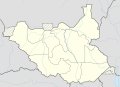 NordNordWest's South Sudan location map showing the Eastern Bieh State in the east with correct borders of the state


I hope you can correct it and upload a new one. Thank you. DinoBambinoNFS (talk) 17:39, 14 August 2016 (UTC)
Thank you for fixing the borders. Can you also please also change the name of Western Bieh to Fangak? The governor of the state had officialy renamed it to Fangak in March 2016 and now the name Fangak is used for it. DinoBambinoNFS (talk) 09:34, 15 August 2016 (UTC)
Change Western Bieh's name to Fangak[edit]
Aotearoa can you change the name of Western Bieh state in your administrative division map? You haven't even replied back. At least reply regardless of whether you want to/can do it or not. Don't leave others in uncertainty. DinoBambinoNFS (talk) 21:59, 16 August 2016 (UTC)
Yiu asked for a official source but the country isn't paid much importance to, asides from its conflicts. I'm not sure if I can find an official source seeing the lack of media coverage. It is hard to even find a reliable source for things concerning South Sudan. The source where your PDF is contained does have a news article saying its name has been changed to Fangak though: Authorities in South Sudan’s Ayod county say 300,000 people in need of food. In media reports after March that I have seen, it is always called Fangak so I doubt the name change is fake. I don't think there is anything that says we need any official source, but still I'll try to find it in the meanwhile. If you can please change it. DinoBambinoNFS (talk) 12:29, 17 August 2016 (UTC)
I'm fine with your proposal as lomg as both the names are readable on the map, the stae's area is small. In the meanwhile I'll try to find an official source. DinoBambinoNFS (talk) 20:58, 17 August 2016 (UTC)
Please create a color-coded map of South Sudan highlighting its regions[edit]
Hello again, I'm looking to create a color-coded image map of South Sudan highlighting regions and showing states within each region. Each color has to represent a region respectively. The map has to be similar to File:SouthSudanStates.svg. I'm asking you because the original author seems to ahve left Wikipedia. I'm linking the image below for reference. DinoBambinoNFS (talk) 08:03, 19 August 2016 (UTC)

Please redraw South Sudan topographic map showing the new states[edit]
Hello Aotearoa. I'm sorry for making another request but can you redraw the topographic map of South Sudan showing boundaries of the new states? The author of the original map is no longer active and his map is based on old states. A new map is needed for shlwing the topography I'm linking his topographic map and a location map showing the boundaries of the new states:
-
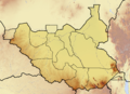 The original topographic map
 -
Location map showing boundaries of new states

I request you to please draw it. Thank you. DinoBambinoNFS (talk) 16:58, 20 August 2016 (UTC)
ArbCom Elections 2016: Voting now open![edit]
Hello, Aotearoa. Voting in the 2016 Arbitration Committee elections is open from Monday, 00:00, 21 November through Sunday, 23:59, 4 December to all unblocked users who have registered an account before Wednesday, 00:00, 28 October 2016 and have made at least 150 mainspace edits before Sunday, 00:00, 1 November 2016.
The Arbitration Committee is the panel of editors responsible for conducting the Wikipedia arbitration process. It has the authority to impose binding solutions to disputes between editors, primarily for serious conduct disputes the community has been unable to resolve. This includes the authority to impose site bans, topic bans, editing restrictions, and other measures needed to maintain our editing environment. The arbitration policy describes the Committee's roles and responsibilities in greater detail.
If you wish to participate in the 2016 election, please review the candidates' statements and submit your choices on the voting page. MediaWiki message delivery (talk) 22:08, 21 November 2016 (UTC)
"Adama Barrow removes 'Islamic' from The Gambia's official name"[edit]
Please stop adding Islamic Republic to the conventional longfrom, as that has since dropped. See: "Adama Barrow removes 'Islamic' from The Gambia's official name". El_C 01:05, 21 February 2017 (UTC)
ArbCom 2017 election voter message[edit]
Hello, Aotearoa. Voting in the 2017 Arbitration Committee elections is now open until 23.59 on Sunday, 10 December. All users who registered an account before Saturday, 28 October 2017, made at least 150 mainspace edits before Wednesday, 1 November 2017 and are not currently blocked are eligible to vote. Users with alternate accounts may only vote once.
The Arbitration Committee is the panel of editors responsible for conducting the Wikipedia arbitration process. It has the authority to impose binding solutions to disputes between editors, primarily for serious conduct disputes the community has been unable to resolve. This includes the authority to impose site bans, topic bans, editing restrictions, and other measures needed to maintain our editing environment. The arbitration policy describes the Committee's roles and responsibilities in greater detail.
If you wish to participate in the 2017 election, please review the candidates and submit your choices on the voting page. MediaWiki message delivery (talk) 18:42, 3 December 2017 (UTC)
ArbCom 2018 election voter message[edit]
Hello, Aotearoa. Voting in the 2018 Arbitration Committee elections is now open until 23.59 on Sunday, 2 December. All users who registered an account before Sunday, 28 October 2018, made at least 150 mainspace edits before Thursday, 1 November 2018 and are not currently blocked are eligible to vote. Users with alternate accounts may only vote once.
The Arbitration Committee is the panel of editors responsible for conducting the Wikipedia arbitration process. It has the authority to impose binding solutions to disputes between editors, primarily for serious conduct disputes the community has been unable to resolve. This includes the authority to impose site bans, topic bans, editing restrictions, and other measures needed to maintain our editing environment. The arbitration policy describes the Committee's roles and responsibilities in greater detail.
If you wish to participate in the 2018 election, please review the candidates and submit your choices on the voting page. MediaWiki message delivery (talk) 18:42, 19 November 2018 (UTC)
ArbCom 2018 election voter message[edit]
Hello, Aotearoa. Voting in the 2018 Arbitration Committee elections is now open until 23.59 on Sunday, 3 December. All users who registered an account before Sunday, 28 October 2018, made at least 150 mainspace edits before Thursday, 1 November 2018 and are not currently blocked are eligible to vote. Users with alternate accounts may only vote once.
The Arbitration Committee is the panel of editors responsible for conducting the Wikipedia arbitration process. It has the authority to impose binding solutions to disputes between editors, primarily for serious conduct disputes the community has been unable to resolve. This includes the authority to impose site bans, topic bans, editing restrictions, and other measures needed to maintain our editing environment. The arbitration policy describes the Committee's roles and responsibilities in greater detail.
If you wish to participate in the 2018 election, please review the candidates and submit your choices on the voting page. MediaWiki message delivery (talk) 18:42, 19 November 2018 (UTC)
Happy Dashain![edit]

![[4]](https://commons.wikimedia.org/wiki/File:Australijskie_Terytorium_Antarktyczne.png)
.svg)
.svg)
.svg)
.svg)
MediaWiki message delivery (talk) 13:07, 7 October 2019 (UTC)
ArbCom 2019 election voter message[edit]
ArbCom 2022 Elections voter message[edit]
Hello! Voting in the 2022 Arbitration Committee elections is now open until 23:59 (UTC) on Monday, 12 December 2022. All eligible users are allowed to vote. Users with alternate accounts may only vote once.
The Arbitration Committee is the panel of editors responsible for conducting the Wikipedia arbitration process. It has the authority to impose binding solutions to disputes between editors, primarily for serious conduct disputes the community has been unable to resolve. This includes the authority to impose site bans, topic bans, editing restrictions, and other measures needed to maintain our editing environment. The arbitration policy describes the Committee's roles and responsibilities in greater detail.
If you wish to participate in the 2022 election, please review the candidates and submit your choices on the voting page. If you no longer wish to receive these messages, you may add {{NoACEMM}} to your user talk page. MediaWiki message delivery (talk) 00:24, 29 November 2022 (UTC)
ArbCom 2023 Elections voter message[edit]
Hello! Voting in the 2023 Arbitration Committee elections is now open until 23:59 (UTC) on Monday, 11 December 2023. All eligible users are allowed to vote. Users with alternate accounts may only vote once.
The Arbitration Committee is the panel of editors responsible for conducting the Wikipedia arbitration process. It has the authority to impose binding solutions to disputes between editors, primarily for serious conduct disputes the community has been unable to resolve. This includes the authority to impose site bans, topic bans, editing restrictions, and other measures needed to maintain our editing environment. The arbitration policy describes the Committee's roles and responsibilities in greater detail.
If you wish to participate in the 2023 election, please review the candidates and submit your choices on the voting page. If you no longer wish to receive these messages, you may add {{NoACEMM}} to your user talk page. MediaWiki message delivery (talk) 00:25, 28 November 2023 (UTC)