
Wikipedia:Graphics Lab/Map workshop/Archive/Dec 2022
| This page is an archive. Do not edit the contents of this page. Please direct any additional comments to the current main page. |
 | Archives of 2023: January, February, March, April, May, June, July, August, September, October, November, December |
Nomascus range map showing each species & subspecies in the article

- Article(s)
- Nomascus
- Request
- Need a replacement map for the gibbon genus Nomascus, as the most recent one was removed due to being out of date. Should include identifiable ranges for each species/subspecies listed in the article, as that's what the previous map had. Sourcing should come from the IUCN maps for the species/subspecies. -- UtherSRG (talk) 12:12, 28 November 2022 (UTC)
- Discussion
 Request taken by M.Bitton (talk) 14:08, 2 December 2022 (UTC).
 Done @UtherSRG: the legends and the source are listed on Commons. M.Bitton (talk) 02:37, 4 December 2022 (UTC)
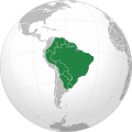
Color Mexico on orthographic projection of Central America
-
 Orthographic projection of Central America without Mexico colored.
 -

.svg)
.svg)
- Article(s)
- Central America
- Request
- Can someone make a map just like the map above but also have Mexico this color: (the color's hex color code is #078732)? It can't be the same shade of green as the other colored countries because Mexico's inclusion in contested. I tried to do it myself but I couldn't figure it out so I'll just leave it to the professionals lol. Thanks in advance! -- Treetoes023 (talk) 20:27, 18 December 2022 (UTC)
- Discussion
- Request taken by M.Bitton (talk) 19:15, 20 December 2022 (UTC).
- Done M.Bitton (talk) 23:33, 20 December 2022 (UTC)
- @Treetoes023: I had to create a new map (given that the old one was full of SVG errors). You'll notice that I opted for a different shade of green, which in my opinion works better in this instance. M.Bitton (talk) 23:45, 20 December 2022 (UTC)
- @M.Bitton: Thank you very much! Looking back you were right that a lighter shade of green would look better to differentiate from the other countries, though I would prefer if it was a bit more solid so it would stick out more. If you are willing to, could you change the color to this color ? I would just prefer a solid color to make Mexico stick out more, you don't have to if you don't want to though. Treetoes023 (talk) 00:02, 21 December 2022 (UTC)
- @Treetoes023: That colour is usually used for contested and occupied countries (it could potentially confuse the readers). I made it darker (check it again and let me know what you think). M.Bitton (talk) 00:21, 21 December 2022 (UTC)
- @M.Bitton: I feel like I'm being too picky right now, but I think it looks too similar to the other countries and I still would prefer if the color was more solid. What about ? Treetoes023 (talk) 00:38, 21 December 2022 (UTC)
- @M.Bitton: Actually, why don't we just use the same shade of green that Commons:File:Middle America (orthographic projection).svg uses to show countries that are sometimes but not always recognized, as it's used by at least one other page. It isn't the prettiest contrast in color, but it does really emphasize the difference between the countries much better for people that may find it hard to tell colors apart. Unfortunately I don't know it's color code. Treetoes023 (talk) 04:24, 21 December 2022 (UTC)
- @Treetoes023: that still doesn't address my concerns (as an editor); and now that you altered the lead sentence of the article, I'm wondering whether having a different colour for Mexico is really justified. I suggest starting a discussion on Talk:Central_America to see what others think. M.Bitton (talk) 13:53, 21 December 2022 (UTC)
- @M.Bitton: Okay, I will start a talk page discussion. As for the color of Mexico, can you change it back to the original color you had it at and I'll stop making you mess with it so we can end this discussion and request. Treetoes023 (talk) 16:25, 21 December 2022 (UTC)
- @M.Bitton: Never mind about changing the color back to the original I found out how to do it. If you want to comment on the talk page discussion I made I'll link it here. Treetoes023 (talk) 18:16, 21 December 2022 (UTC)
- @M.Bitton: Okay, I will start a talk page discussion. As for the color of Mexico, can you change it back to the original color you had it at and I'll stop making you mess with it so we can end this discussion and request. Treetoes023 (talk) 16:25, 21 December 2022 (UTC)
- @Treetoes023: that still doesn't address my concerns (as an editor); and now that you altered the lead sentence of the article, I'm wondering whether having a different colour for Mexico is really justified. I suggest starting a discussion on Talk:Central_America to see what others think. M.Bitton (talk) 13:53, 21 December 2022 (UTC)
- @M.Bitton: Actually, why don't we just use the same shade of green that Commons:File:Middle America (orthographic projection).svg uses to show countries that are sometimes but not always recognized, as it's used by at least one other page. It isn't the prettiest contrast in color, but it does really emphasize the difference between the countries much better for people that may find it hard to tell colors apart. Unfortunately I don't know it's color code. Treetoes023 (talk) 04:24, 21 December 2022 (UTC)
- @M.Bitton: I feel like I'm being too picky right now, but I think it looks too similar to the other countries and I still would prefer if the color was more solid. What about ? Treetoes023 (talk) 00:38, 21 December 2022 (UTC)
- @Treetoes023: That colour is usually used for contested and occupied countries (it could potentially confuse the readers). I made it darker (check it again and let me know what you think). M.Bitton (talk) 00:21, 21 December 2022 (UTC)
- @M.Bitton: Thank you very much! Looking back you were right that a lighter shade of green would look better to differentiate from the other countries, though I would prefer if it was a bit more solid so it would stick out more. If you are willing to, could you change the color to this color ? I would just prefer a solid color to make Mexico stick out more, you don't have to if you don't want to though. Treetoes023 (talk) 00:02, 21 December 2022 (UTC)
- @Treetoes023: I had to create a new map (given that the old one was full of SVG errors). You'll notice that I opted for a different shade of green, which in my opinion works better in this instance. M.Bitton (talk) 23:45, 20 December 2022 (UTC)
{{resolved}}
Locator map of the Sahara


- Article(s)
- Sahara
- Request
- Create a locator map of the Sahara with the green and grey globe scheme. -- Treetoes023 (talk) 06:50, 9 January 2023 (UTC)
- Discussion
- Request taken by M.Bitton (talk) 20:36, 9 January 2023 (UTC).
- Done combined with #Locator map of Sub-Saharan Africa (see below). M.Bitton (talk) 22:20, 18 January 2023 (UTC)
{{resolved}}
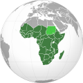
Locator map of sub-Saharan Africa
-
 Map of Sub-Saharan Africa
 -
 The SaharaThe SahelSub-Saharan Africa
 -
 Map of Sub-Saharan Africa


- Article(s)
- Sub-Saharan Africa
- Request
- Create a locator map of sub-Saharan Africa with the green and grey globe scheme. -- Treetoes023 (talk) 04:45, 10 January 2023 (UTC)
- Discussion
- Request taken by M.Bitton (talk) 01:08, 11 January 2023 (UTC).
- Done @Treetoes023: given the fact that the areas are interlinked, I combined the two requests (this and #Locator map of the Sahara) and created a map that in my view is more educational, as it shows the Sahara, sub-Saharan Africa and the Sahel, giving the reader a better understanding of where each one is and how it relates to the others. I have also uploaded the individual maps (just in case they are preferred). M.Bitton (talk) 22:20, 18 January 2023 (UTC)
- @M.Bitton: Wow, this is amazing! You covered all of your bases, including the ones I didn't think of! Could you make a map with the Sahara and Sahel but not sub-Saharan Africa? Treetoes023 (talk) 13:46, 19 January 2023 (UTC)
- @M.Bitton: Also, regarding the map of solely sub-Saharan Africa, can you make a map that includes the Sahel as the sub-Saharan Africa article includes it as part of sub-Saharan Africa. Treetoes023 (talk) 16:43, 19 January 2023 (UTC)
- @Treetoes023: no issue with the second request (the Sahara and the Sahel), but the Sahel is definitely not part of sub-Saharan Africa. M.Bitton (talk) 16:53, 19 January 2023 (UTC)
- @M.Bitton: I thought so too but the sub-Saharan Africa article includes the Sahel as part of sub-Saharan Africa, and the definition of sub-Saharan Africa is all land on continental Africa south of the Sahara and since the Sahel is not a part of the Sahara but south of it, the Sahel technically fits the requirements. Treetoes023 (talk) 16:59, 19 January 2023 (UTC)
- @Treetoes023: in that case, it's the article itself that needs correcting. M.Bitton (talk) 17:04, 19 January 2023 (UTC)
- @Treetoes023: The trouble with these concepts and their loose definitions is that they end up contradicting each other (that was the reason behind the creation of a map that combines all three). Sorting the messy articles will take some time, but meanwhile, one possible solution would be to adjust the size of the Sahel region, using this map for instance, which would make the combination of the Sahel and sub-Saharan Africa look closer to the map that was in the article. M.Bitton (talk) 18:08, 19 January 2023 (UTC)
- @M.Bitton: I decided just to use this image so we can close the discussion. Treetoes023 (talk) 20:12, 19 January 2023 (UTC)
- @M.Bitton: I thought so too but the sub-Saharan Africa article includes the Sahel as part of sub-Saharan Africa, and the definition of sub-Saharan Africa is all land on continental Africa south of the Sahara and since the Sahel is not a part of the Sahara but south of it, the Sahel technically fits the requirements. Treetoes023 (talk) 16:59, 19 January 2023 (UTC)
- @Treetoes023: no issue with the second request (the Sahara and the Sahel), but the Sahel is definitely not part of sub-Saharan Africa. M.Bitton (talk) 16:53, 19 January 2023 (UTC)
- @M.Bitton: Also, regarding the map of solely sub-Saharan Africa, can you make a map that includes the Sahel as the sub-Saharan Africa article includes it as part of sub-Saharan Africa. Treetoes023 (talk) 16:43, 19 January 2023 (UTC)
- @M.Bitton: Wow, this is amazing! You covered all of your bases, including the ones I didn't think of! Could you make a map with the Sahara and Sahel but not sub-Saharan Africa? Treetoes023 (talk) 13:46, 19 January 2023 (UTC)
{{resolved}}
Capybara range map
-
 Old image to be updated or replaced
 -
 Finished map


- Article(s)
- Capybara
- Request
- Current map needs to be updated or replaced, using info from https://www.iucnredlist.org/species/10300/22190005 - UtherSRG (talk) 02:25, 9 December 2022 (UTC)
- Discussion
- Request taken by M.Bitton (talk) 20:53, 12 December 2022 (UTC).
- Done @UtherSRG: since the range is rather large, I opted for an orthographic projection. Please let me know if that's not what you had in mind. M.Bitton (talk) 01:27, 14 December 2022 (UTC)
{{resolved}}
Outdated map of signatories and parties
-
 Status as of July 2007
 -
 Finished SVG version


- Article(s)
- Aarhus Protocol on Persistent Organic Pollutants
- Request
- The map of signatories and parties was created 15 years ago. Meanwhile, there are 36 signatories and 34 parties. --2001:67C:10EC:574F:8000:0:0:134 (talk) 21:55, 10 December 2022 (UTC)
- Discussion
- Request taken by M.Bitton (talk) 20:53, 12 December 2022 (UTC).
- Done M.Bitton (talk) 21:39, 12 December 2022 (UTC)
Thank you very much. 2001:67C:10EC:574F:8000:0:0:59 (talk) 22:04, 13 December 2022 (UTC) {{resolved}}
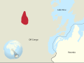
Update map for species range
-
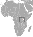 Current range map
 -
 Myosorex jejei - Extant (resident)


- Article(s)
- Kahuzi swamp shrew
- Request
- Range is fairly small. Need a better map where we can understand where the range is and what the range looks like. IUCN is the goto place for data. Could be an Africa map with an inset blowup of the boxed range. -- UtherSRG (talk) 19:00, 24 December 2022 (UTC)
- Discussion
- Request taken by M.Bitton (talk) 16:20, 2 January 2023 (UTC).
- Done @UtherSRG: I hope that's what you had in mind. M.Bitton (talk) 14:24, 5 January 2023 (UTC)
{{resolved}}
Ontario line
- Article(s)
- Ontario Line
- Request
- Hello, there's a diagram in the article already ([1]) by Transportfan70. The diagram is lovely, but it doesn't show anything geographically - hence this request. Are you able to build a geographical map based on this non-free map (https://www.metrolinx.com/images/greaterregion/projects/ontario-line/ontario-line-map-20220511.pdf)?
- It should show Lake Ontario, the main east-west and north-south subway lines and the major railway lines. Perhaps only naming interchange stations (as well as Union station), but marking where other stations are/would be located, would reduce clutter on the map. Could you also label existing lines with a solid line, and indicate the Ontario line with a dotted one as "proposed"? It wouldn't need to include the colour coding or the tunnel portals shown on the Metrolinx map.
- Here's another example of a non-free versions ([2]) Turini2 (talk) 09:58, 6 October 2022 (UTC)
- Discussion
- I don't really want to do that, because my maps are meant to be basic diagrams of the non-mainline rapid transit system (as others were before). As for reducing clutter on the map, you need to show the Ontario Line stations, but I didn't put in non-Ontario Line stations, except for the relevant interchanges.Transportfan70 (talk) 14:35, 6 October 2022 (UTC)
- @Transportfan70 Ah, it wasn't a request for you to do it - that's why I came here to ask others :) Turini2 (talk) 14:52, 6 October 2022 (UTC)
- I made the map and was notified, so it made sense for me to respond. Transportfan70 (talk) 16:12, 6 October 2022 (UTC)

- Request taken by Lommes (talk) 15:50, 7 November 2022 (UTC).
- Hey Turini2, i made a first draft of the map. I used your provided map as a reference, but i didn't simply copy it, which is necessary for this to become a free map. I left the colors garish on purpose, so noone can mistake this work-in-progress for a finished map. Please tell me which stations i should add, or what else you think needs to be changed (besides colors). Please also keep in mind that the only knowledge i have of Toronto transit is a couple of RMTransit videos on youtube. Cheers.--Lommes (talk) 15:50, 7 November 2022 (UTC)
- Oh wonderful. If you could label the Ontario line stations - perhaps with a dash, and indicating the interchange stations (Exhibition, Osgoode, Queen, East Harbour, Pape and Science Centre) with circles like you've done at Union? If you then label the lake as "Lake Ontario" and make it a little less garish? I think the single colours for the GO Transit and Subway lines are fine, if you label them with a legend of course. Thanks!
- @Johnny Au any thoughts? Turini2 (talk) 21:00, 9 November 2022 (UTC)
- Each station needs to be labelled. Lake Ontario needs to be labelled. If the map is to scale, add a scale. If the map is not to scale, then there should be a note saying that the map is not to scale. Most importantly, there should be a legend and a north arrow (a compass rose would be too fancy). Johnny Au (talk/contributions) 01:15, 10 November 2022 (UTC)
- @Turini2 @Johnny Au: I had completely forgotten about this. Please always ping me when answering. Unfortunately I am very busy outside Wikipedia right now and can't continue this at the moment, likely not during the next week or two. I advise you to close this and make a new request. Given I have already vectorised the basic map elements, the remaining tasks should not be much more than 30mins work. The thing is, I can't spend these 30mins right now. If you don't wanna go through this again, I will come back to you, but it might take a couple weeks. I declare this request abandonedfor now. Apologies. --Lommes (talk) 20:01, 22 November 2022 (UTC)
- @Lommes: No problem. Take your time. There are no deadlines. Johnny Au (talk/contributions) 01:39, 23 November 2022 (UTC)
- @Turini2 @Johnny Au: I had completely forgotten about this. Please always ping me when answering. Unfortunately I am very busy outside Wikipedia right now and can't continue this at the moment, likely not during the next week or two. I advise you to close this and make a new request. Given I have already vectorised the basic map elements, the remaining tasks should not be much more than 30mins work. The thing is, I can't spend these 30mins right now. If you don't wanna go through this again, I will come back to you, but it might take a couple weeks. I declare this request
- Each station needs to be labelled. Lake Ontario needs to be labelled. If the map is to scale, add a scale. If the map is not to scale, then there should be a note saying that the map is not to scale. Most importantly, there should be a legend and a north arrow (a compass rose would be too fancy). Johnny Au (talk/contributions) 01:15, 10 November 2022 (UTC)
- Hey Turini2, i made a first draft of the map. I used your provided map as a reference, but i didn't simply copy it, which is necessary for this to become a free map. I left the colors garish on purpose, so noone can mistake this work-in-progress for a finished map. Please tell me which stations i should add, or what else you think needs to be changed (besides colors). Please also keep in mind that the only knowledge i have of Toronto transit is a couple of RMTransit videos on youtube. Cheers.--Lommes (talk) 15:50, 7 November 2022 (UTC)
The user Transportfan70 posted the following on my talk page. I can't deal with this right now, I am currently inactive on Wikipedia, and will remain so for at least another week, quite possibly until the end of the year. As this relates to this map request, I nonetheless wanted to relay this message.
I see there's a discussion on changing my Ontario Line map due to a lack of geographical placing. Is that even an issue? Its a example of the system maps shown at stations and on trains, which don't stress geographical placing.
Transportfan70, https://en.wikipedia.org/w/index.php?title=User_talk:Lommes
I wish you all the best. Cheers! --Lommes (talk) 12:12, 10 December 2022 (UTC)
How do I change Commons-map line colors from their defaults?

- Article(s)
- Lake Street Transfer station
- Request
- I'd like to change the line colors from their Commons defaults to the colors implied in the code, and haven't been able to do so. This is fairly urgent, as it is for Lake Street Transfer station currently at FAC. Thanks! – John M Wolfson (talk • contribs) 02:00, 11 December 2022 (UTC)
- Discussion
Map needed for Basiliscus Today's featured article
I want to run this article at TFA on January 13, 2023, but the discussion here pointed out that the existing map File:Europe and the Near East at 476 AD.png is unsourced. It also suggested a couple of possible sources for a potential similar map. Is there any prospect of doing this in the fairly short term? Jimfbleak - talk to me? 11:21, 13 December 2022 (UTC)
A map of Katzianer's Campaign
Article(s)
Request {{resolved}}
Hello everyone,
I was wondering if anyone would be willing to make a map of 1537 Katzianer's Campaign. I feel that both Katzianer's Campaign and Hundred Years' Croatian–Ottoman War could really use this map. I wrote the article about the campaign and I can provide you with all the information about locations and the troop movements, but I don't have the actual skill to create the map myself.
Thanks in advance. Franjo Tahy (talk) 14:13, 3 December 2022 (UTC)
Discussion
![]() Request taken by --always ping me-- Goran tek-en (talk) 15:51, 3 January 2023 (UTC).
Request taken by --always ping me-- Goran tek-en (talk) 15:51, 3 January 2023 (UTC).
Franjo Tahy So please provide me with all the needed info and we will work from there but I will need your help all the way, thanks. --always ping me-- Goran tek-en (talk) 15:51, 3 January 2023 (UTC)
- Franjo Tahy I can't do this without your help and knowledge so I have to withdraw my take. If you still want my help please contact me. --always ping me-- Goran tek-en (talk) 17:53, 13 January 2023 (UTC)
- Franjo Tahy I got your message and I will then help you here. First we have to decide on the over all area the map should cover, can you give me coordinates or draw a rectangle on a map to show me. Then you have to tell me what you want included in the map regarding topographic, citys, roads etc and if we already have some maps I can work from. After that you will have to provide me with what info you want included for the actual campaigns, troop movements. Please remember I have zero knowledge so you have to tell me what you need and please ping me, thanks. --always ping me-- Goran tek-en (talk) 19:37, 13 January 2023 (UTC)
- @Goran tek-en The area which we want to cover is area of what is today region of Slavonia in Croatia. In other words, the part of land between Drava and Sava rivers, as all of the events concerning this campaign actually happen in that area. The Campaign itself was actually (a failed) attempt to liberate Slavonia from the Ottomans. You can see the non-free map of this area here. This line stretching from Osijek across Gorjani, towards Požega-Blagaj-Bihać-Novigrad towards Vrana, shows the state of borders as they were in 1537 when this campaign took place.
- We do not need many details on our final map, my vision of it is rather simple - something similar to Ceasar's campaign to Munda. We need a simple map of contested area, with the most esential towns and one arrow which would show the direction of the marching Habsburg army and a battle symbol which would mark The Battle of Gorjani, where this whole campaign ended.
- When it comes to troop movements, we can rely on Vjekoslav Klaić's History of the Croats, who described it all nicely. According to Klaić, the Habsburg army's staging area was the town of Koprivnica (these are all marked on the map). Once assembled, the troops followed Drava river towards Virovitica, from where they marched on to Valpovo, where they were preparing to strike on Ottoman controled Osijek. As the Ottomans sent reinforcements from Belgrade to Osijek, and blocked Habsburg retreat towards Valpovo, Habsburg commander Katzianer withdrew his army south west-ish to Gorjani, where the final Battle took place and the Habsburg army was destroyed. So just make one arrow going from one town to another and then ending in Battle of Gorjani. Franjo Tahy (talk) 22:59, 13 January 2023 (UTC)
- @Franjo Tahy Sorry but I don't understand precisely which area you mean. Can you draw a rectangle on this print screen and show to me in some way or send it to me by email, thanks. --always ping me-- Goran tek-en (talk) 19:10, 14 January 2023 (UTC)
- @Goran tek-en Here is the rectangle. Just bear in mind that international borders were different back in 16 century, but you can see their 1537 state on this map. Franjo Tahy (talk) 20:04, 14 January 2023 (UTC)
- Franjo Tahy I don't understand what copyright there is on this map, I need to know if I can "copy" it or just use it as information source? --always ping me-- Goran tek-en (talk) 12:51, 15 January 2023 (UTC)
- @Goran tek-en The licence says that this map was uploaded with the permission of website Herceg-Bosna.org. I shall e-mail them and ask them for permission. Franjo Tahy (talk) 13:39, 15 January 2023 (UTC)
- @Franjo Tahy Very nice of you. Just remember it's a difference if it's uploaded to wikipedia or to commons and what we can do with material differs also. --always ping me-- Goran tek-en (talk) 15:40, 15 January 2023 (UTC)
- @Franjo Tahy In the non-free map you are reffering to the borders, there are several.
- Do you want both the 1526 (red solid) and 1537 (red dashed) borders as marked in the legend? --always ping me-- Goran tek-en (talk) 14:26, 16 January 2023 (UTC)
- @Goran tek-en Naah, we don't need both borders. We just need those from 1537 (red dashed), as it is the actual year of Katzianer's Campaign.
- Quick update about the copyright: it turns out that the map was actually made by Croatian School Cartography, so I e-mailed them. I received a response from their principal who told me that the edition which we wanted to use here "is not in use anymore", and if we want to refer to their map, "we can do it in 2014 edition" of this map. I will therefore visit the library today to find 2014 edition and I will share it with you here with you sometime today or tomorrow. Franjo Tahy (talk) 10:13, 17 January 2023 (UTC)
- @Franjo Tahy If it's a lot of trouble, don't bother I think using it as "information" will be enough, thanks for your efforts. --always ping me-- Goran tek-en (talk) 10:47, 17 January 2023 (UTC)
- @Franjo Tahy
- ----
- Those drafts are PNG versions of the original SVG file I'm working in and will upload to commons.
- Those drafts are shown for proofreading only.
- ----
- This draft 1 is just for the base map.
- Tell me what to add/remove/edited
- To me it's very strange just to have borders like that, not ending to another border or something
- Are there no countries, areas which should be shown and labelled
- The stretching of the rivers are from today's maps so if there are any important differences from back then just tell me
- --always ping me-- Goran tek-en (talk) 11:49, 17 January 2023 (UTC)
- @Goran tek-en The draft you made seems about right, I appreciate your effort. I found the 2014 version of the map, although it seems to me that they are virtually the same.
- • I would suggest adding Bihać this map, as it was one of larger Croatian towns back then and defensive outpost in this war. And maybe if possible Szigetvar and Belgrade.
- • From what I can see on the map, the border northwards continues along Drava river near Osijek and then Danube river towards Hungary.
- • The area here in zoomed in on a border between Habsburg Monarchy and Ottoman Empire. We could search for Ottoman Eyalets or Sanjaks from that time, but it would be irellevant for the topic and it would just complicate the matter.
- • I don't have any info on the rivers, but I guess we can also refer to the maps that we have for that. Franjo Tahy (talk) 15:19, 17 January 2023 (UTC)
- @Franjo Tahy
- Belgrade is just outside of the area the map area you told me to use. Do you want to add a bit to the east?.
- "From what I can see ..", yeas but you told me just to add the dashed line.
- Tell me what borders to add from Ostaci_ostataka.jpg
- There must be some kind of names to the different countries, areas, the map is strange without that info.
- "The area here in zoomed ...", I don't understand what you want me to do. Giving me links to different wikipedia pages often doesn't tell me what to do. Please be specific.
- A map is supposed to be legible for most people, even the ones who has zero knowledge of the subject. Try to disregard all the knowledge you have about this subject when thinking of what to show.
- --always ping me-- Goran tek-en (talk) 18:10, 17 January 2023 (UTC)
- @Goran tek-en Just make it look something like this, and it will be alright. ;) Franjo Tahy (talk) 22:02, 17 January 2023 (UTC)
- @Franjo Tahy
- I guess you think I bother to much about a lot in creating a map like this, but this is what I do and I do want the map (any media) created here to be as useful and as well functioning as possible.
- Here are my personal reflections.
- There still is the border that ends in nothing just north of Virovitica.
- There is so much unnecessary space around the interesting part, why?
- As you wrote before, Belgrade is of interest so why not move the map area a bit to the east and add it.
- I do see that Zagreb might be somewhat important but it's not described by you so maybe it's not so important.
- When you have so much unnecessary space around the most interesting part, the preview of the map that you add to the article will be very hard to view (this is often a problem). This is how it will look at 250 px wide.
- You just asked me to add the forward movement of Katzianer's army. But you also write about retreats and withdrawals, should that not also be shown?
- Should not the opposing army movements also be added, you can't have a battle with just one part.
- --always ping me-- Goran tek-en (talk) 12:38, 21 January 2023 (UTC)
- That's okay.
- 1) The border which ends north of Virovitica is the border between Slavonia/Croatia and Hungary. By referring to the 2014 map, you can continue that border to follow the red area in the map marked as Hrvatska (Croatia). However, this is just an internal border of Habsburg Monarchy as both Kingdom of Croatia and Kingdom of Hungary back then were parts of Habsburg Monarchy.
- 2) What do you consider to be "the interesting part"?
- 3) If you feel it is not too much trouble for you, you can add Belgrade as well. Part of the Ottoman reinforcements probably arrived to Osijek from somewhere in Serbia (maybe Belgrade) as well as Bosnia, although in Klaić's text which we use to reconstruct, it is not written precisely. Here is what Klaić wrote:
- "However the Turks weren't idle either. Mehmed Bey Jahjapašić, the sanjak-bey of Smederevo and Belgrade aided Osijek at the right time. Then, after also receiving 5000 men from Bosnian pasha, he had set the town defences so Katzianer could not even consider beseiging [the Osijek] regularly".
- If you feel like it, you can add the Ottoman reinforcements too. The text further says that the Ottoman army blocked Katzianer's withdrawal from Osijek to Valpovo and as he retreated towards Gorjani, they harrased his rear. It seems to me though that this is too complex to show on this map.
- 4) Zagreb was just one of larger towns, but for Katzianer's campaign itself, it is not that important.
- 5) Withdrawal of Katzianer's army is this arrow between Osijek and Gorjani. Anything that goes after Osijek is basicly withdrawal. Franjo Tahy (talk) 18:00, 21 January 2023 (UTC)
- @Goran tek-en Sorry, forgot to tag. Check previous comment. Franjo Tahy (talk) 18:00, 21 January 2023 (UTC)
- @Goran tek-en One more thing. This little gray map on the top right corner, which gives the European perspective on the region is a bit problematic because it shows the borders of the contemporary Europe.
- Our map is dealing with 16th century event, so we need a 16th century map. Franjo Tahy (talk) 15:34, 24 January 2023 (UTC)
- @Franjo Tahy I didn't see this before my post below. Yeas that is true. But if anyone should be able to understand which area we are using I think we need to use today's borders otherwise many will be lost.
- There are two options as I see it:
- We can remove all borders and just have grey areas
- We can add some explaining text, "Today's borders" or something close by the grey maps.
- --always ping me-- Goran tek-en (talk) 15:54, 24 January 2023 (UTC)
- @Franjo Tahy
- 1
- The type of border line I use is what our template call "Province / Region" and not a country border as I thought that this was more appropriate. If you want any other type from that template just tell me.
- - Please check the borders stretching.
- 2
- To my understanding this would be the interesting part. It shows the movements with some space around.
- 3-5
- Based on the information above I didn't add Belgrade as it would make the map even wider.
- Thanks for that info, now I think I understand more.
- Here is a draft on the smaller area (more interesting) and with more added based on your information. Please check everything as I changed a lot of the included stuff.
- Here is how this smaller area map looks as a thumbnail 250 px. --always ping me-- Goran tek-en (talk) 15:49, 24 January 2023 (UTC)
- The draft of a smaller area you made looks awesome. I say we should keep it, we just have to make minor corrections.
- 1) Both Slavonia and Hungary belong to the Habsburg Monarchy. Not to go into too many details but it is safe to consider them both as Habsburg provinces. So they are both part of the same Kingdom.
- 2) That being said, this diagonal border streching between the bottom left of the map, to the upper right corner of the map is actually a country border, as suggested on the template.
- 3) When Ottoman reinforcements arrived, historian Klaić (to which we refer to here), says that Katzianer's shortest retreat to Valpovo was blocked by the Ottomans, forcing him to retreat in less favourable direction towards Gorjani. My point is that we should also add one arrow representing part of the Ottoman army which blocked his direct retreat towards Valpovo. Something like this.
- Franjo Tahy (talk) 17:53, 24 January 2023 (UTC)
- @Goran tek-enAlso, when it comes to two options which you suggested in your 15:54 post, I vote for the option number 1 - just leave it all gray and remove borders. Franjo Tahy (talk) 17:58, 24 January 2023 (UTC)
- @Franjo Tahy
- New draft-4. --always ping me-- Goran tek-en (talk) 20:56, 27 January 2023 (UTC)
- @Goran tek-enThis looks rather good, I like it. Just few things; the name of the river northeast of Osijek is Dunav, not Duna. This is Danube in its Slavic variant. You can write either Dunav, or Danube, it's the same.
- When it comes to Katzianer's retreat from Osijek, we want to assume that he firstly took the shortest route back to Valpovo, but it was blocked in the meantime. Klaić writes: "in the first days of October, Katzianer and his exhausted army started their withdrawal [from Osijek]. But even here, Turks overpassed him, as **they blocked his shortest and best route from Osijek to Valpovo**. Therefore, the Christian army was pushed southwest into swampy areas near Vuka river. But even here, the Turks harrased the army by chasing them and causing them many missery..." ... ending in Battle of Gorjani.
- Other than that, the map is good. When it is adjusted, can you upload this to Commons? Franjo Tahy (talk) 11:08, 28 January 2023 (UTC)
- Let me clarify my last comment about "shortest and best route from Osijek to Valpovo" - can you make the arrow showing Katzianer's attempt to withdraw to Valpovo straght, and the arrow showing Ottomans blocking his path back curvy as they "overpassed him" @Goran tek-en Franjo Tahy (talk) 11:17, 28 January 2023 (UTC)
- @Franjo Tahy
- Was Osjiek held by the Ottomans before/when Katzianer' tried to conquer it? --always ping me-- Goran tek-en (talk) 16:15, 28 January 2023 (UTC)
- @Franjo Tahy I'm tying to avoid arrows (e.g. blue over red) crossing each other as this is very unclear when the crossing took place, at the same time, did one army pass before etc. --always ping me-- Goran tek-en (talk) 16:19, 28 January 2023 (UTC)
- @Goran tek-en Yes, the Ottomans conquered Osijek in 1526; some ten years prior.
- Alright. Then just add letter v to Dunav. Franjo Tahy (talk) 17:14, 28 January 2023 (UTC)
- @Franjo Tahy Sorry I wasn't clear enough.
- I needed that information to try a new draft, I didn't mean it couldn't be done.
- Draft 5.
- If this is fine I will need the following;
- Name of the file
- Description (/language)
- Captions/s (/language)
- Category/ies at commons
- Structured data/Items portrayed in this file, the Q#, to be able to upload it at commons, thanks.
- --always ping me-- Goran tek-en (talk) 18:42, 28 January 2023 (UTC)
- I see only one mistake on Draft 5 - Bosnia is south of Sava river. Anything north of Sava river is Slavonia. The simplest solution would be to just remove Bosnia inscription.
- Other than that, the map is alright and it is good to be published.
- Name of the file: Katzianer's Campaign Map
- Description: A map of 1537 Katzianer's Campaign
- Cat: 16th century Croatia maps
- Not sure what to write about rest...
- @Goran tek-enFranjo Tahy (talk) 23:53, 28 January 2023 (UTC)
- @Franjo Tahy Now you can find it here Katzianer's Campaign Map.
- Please check all the information, also links for wikipedia, wikidata and structured data.
- If you are happy with this please put the code
{{re.solved|~~~~}}(without the ".") on this request so it can be archived, thanks. Done
- --always ping me-- Goran tek-en (talk) 14:14, 29 January 2023 (UTC)
{{tl|resolved|~~~~}}@Goran tek-en Thank you for your contribution, really appreciate it. Franjo Tahy (talk) 14:49, 29 January 2023 (UTC)
- @Franjo Tahy Now you can find it here Katzianer's Campaign Map.
- Let me clarify my last comment about "shortest and best route from Osijek to Valpovo" - can you make the arrow showing Katzianer's attempt to withdraw to Valpovo straght, and the arrow showing Ottomans blocking his path back curvy as they "overpassed him" @Goran tek-en Franjo Tahy (talk) 11:17, 28 January 2023 (UTC)
- @Goran tek-enAlso, when it comes to two options which you suggested in your 15:54 post, I vote for the option number 1 - just leave it all gray and remove borders. Franjo Tahy (talk) 17:58, 24 January 2023 (UTC)
- @Goran tek-en Sorry, forgot to tag. Check previous comment. Franjo Tahy (talk) 18:00, 21 January 2023 (UTC)
- @Goran tek-en Just make it look something like this, and it will be alright. ;) Franjo Tahy (talk) 22:02, 17 January 2023 (UTC)
- @Franjo Tahy
- @Franjo Tahy Very nice of you. Just remember it's a difference if it's uploaded to wikipedia or to commons and what we can do with material differs also. --always ping me-- Goran tek-en (talk) 15:40, 15 January 2023 (UTC)
- @Goran tek-en The licence says that this map was uploaded with the permission of website Herceg-Bosna.org. I shall e-mail them and ask them for permission. Franjo Tahy (talk) 13:39, 15 January 2023 (UTC)
- Franjo Tahy I don't understand what copyright there is on this map, I need to know if I can "copy" it or just use it as information source? --always ping me-- Goran tek-en (talk) 12:51, 15 January 2023 (UTC)
- @Goran tek-en Here is the rectangle. Just bear in mind that international borders were different back in 16 century, but you can see their 1537 state on this map. Franjo Tahy (talk) 20:04, 14 January 2023 (UTC)
- @Franjo Tahy Sorry but I don't understand precisely which area you mean. Can you draw a rectangle on this print screen and show to me in some way or send it to me by email, thanks. --always ping me-- Goran tek-en (talk) 19:10, 14 January 2023 (UTC)
- Franjo Tahy I got your message and I will then help you here. First we have to decide on the over all area the map should cover, can you give me coordinates or draw a rectangle on a map to show me. Then you have to tell me what you want included in the map regarding topographic, citys, roads etc and if we already have some maps I can work from. After that you will have to provide me with what info you want included for the actual campaigns, troop movements. Please remember I have zero knowledge so you have to tell me what you need and please ping me, thanks. --always ping me-- Goran tek-en (talk) 19:37, 13 January 2023 (UTC)
Niue Nukutuluea (Niue EEZ division)
-
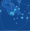 Niue's EEZ
 -
 Niue's EEZ division


.svg)
![[1]](https://en.wikipedia.org/wiki/File:Ontario_Line_route.svg)
![[2]](https://i.ytimg.com/vi/X9eYXZCQEGg/maxresdefault.jpg)
- Article(s)
- Under development
- Request
Hello, I am looking for a map of the Niue Nukutuluea Marine Protected Area. This protected area spans the entirety of Niue's EEZ, which is divided into five zones: 1) Moana Mahu Marine Protected Area 2) Beveridge Reef Nukutulueatama Special Management Area (within the Moana Mahu Marine Protected Area) 3) Everywhere within 3 nautical miles of Niue Island 4) A band between 3 nautical miles and 24 nautical miles 5) A general use area (everything else)
The total EEZ, along with 1, 4, and 5 above is visible here, including some specific coordinates.
That map can also be seen here, along with a map of the small Beveridge rectangle and its coordinates.
A shapefile for the whole EEZ can be found here.
I don't have a border for the 3nmi area, but hopefully that is easy enough to calculate from the surrounding band (4)?
I hope this all makes sense! Thanks if this is possible, CMD (talk) 14:39, 27 January 2023 (UTC)
- Discussion
I will look into and get back to you. M.Bitton (talk) 15:01, 27 January 2023 (UTC)
- @Chipmunkdavis: am I correct in assuming that the area has the shape of the 200nm EEZ and includes everything within 3 nautical miles and 200 nautical miles? M.Bitton (talk) 00:26, 28 January 2023 (UTC)
- It includes all water from the coast to the end of the EEZ (not always 200 nmi due to borders with neighbouring EEZs). CMD (talk) 02:36, 28 January 2023 (UTC)
- @Chipmunkdavis: I created two maps: the second is hopefully what you're after. The first has a different background that could be useful for creating maps for the individual zones. Both have been edited by hand, making them easily customizable (apart from the background, the first is a derivative of the second). Please have a look and let me know what you think. M.Bitton (talk) 18:58, 28 January 2023 (UTC)
- These are very cool! The second is what I was thinking about, works great and nice guess on the 3nmi area. (Different to mine, but no idea which is right.) The first shows depth? If so it might be very useful on other articles. CMD (talk) 01:26, 29 January 2023 (UTC)
- This is now in use at Niue Nukutuluea. Thank you very much, marking as {{resolved}}
- These are very cool! The second is what I was thinking about, works great and nice guess on the 3nmi area. (Different to mine, but no idea which is right.) The first shows depth? If so it might be very useful on other articles. CMD (talk) 01:26, 29 January 2023 (UTC)
- @Chipmunkdavis: I created two maps: the second is hopefully what you're after. The first has a different background that could be useful for creating maps for the individual zones. Both have been edited by hand, making them easily customizable (apart from the background, the first is a derivative of the second). Please have a look and let me know what you think. M.Bitton (talk) 18:58, 28 January 2023 (UTC)
- It includes all water from the coast to the end of the EEZ (not always 200 nmi due to borders with neighbouring EEZs). CMD (talk) 02:36, 28 January 2023 (UTC)