
File:Brill tramway system diagram.png

Size of this preview: 800 × 566 pixels. Other resolutions: 320 × 226 pixels | 640 × 453 pixels | 1,052 × 744 pixels.
Original file (1,052 × 744 pixels, file size: 79 KB, MIME type: image/png)
| This is a file from the Wikimedia Commons. Information from its description page there is shown below. Commons is a freely licensed media file repository. You can help. |

|
This rail transport map image could be re-created using vector graphics as an SVG file. This has several advantages; see Commons:Media for cleanup for more information. If an SVG form of this image is available, please upload it and afterwards replace this template with
{{vector version available|new image name}}.
It is recommended to name the SVG file “Brill tramway system diagram.svg”—then the template Vector version available (or Vva) does not need the new image name parameter. |
Summary
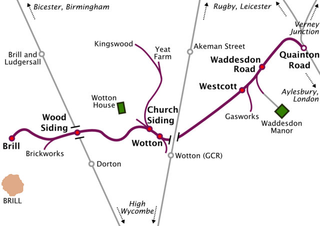
| Description | The Brill Tramway and associated lines |
| Date | |
| Source |
Own work using:
|
| Author | Iridescent |
| Other versions | Derivative works of this file: Brill tramway system diagram.svg |
Licensing
I, the copyright holder of this work, hereby publish it under the following licenses:
This file is licensed under the Creative Commons Attribution-Share Alike 3.0 Unported license.
- You are free:
- to share – to copy, distribute and transmit the work
- to remix – to adapt the work
- Under the following conditions:
- attribution – You must give appropriate credit, provide a link to the license, and indicate if changes were made. You may do so in any reasonable manner, but not in any way that suggests the licensor endorses you or your use.
- share alike – If you remix, transform, or build upon the material, you must distribute your contributions under the same or compatible license as the original.

|
Permission is granted to copy, distribute and/or modify this document under the terms of the GNU Free Documentation License, Version 1.2 or any later version published by the Free Software Foundation; with no Invariant Sections, no Front-Cover Texts, and no Back-Cover Texts. A copy of the license is included in the section entitled GNU Free Documentation License. |
You may select the license of your choice.
File history
Click on a date/time to view the file as it appeared at that time.
| Date/Time | Thumbnail | Dimensions | User | Comment | |
|---|---|---|---|---|---|
| current | 16:56, 1 May 2017 | | 1,052 × 744 (79 KB) | Jeanjung212 | Lossless Compressed/optimized png decreasing file size by 41024 bytes |
| 18:21, 9 July 2010 |  | 1,052 × 744 (119 KB) | Iridescent | Fix location of Westcott station | |
| 16:08, 9 July 2010 |  | 1,052 × 744 (120 KB) | Iridescent | reposition label for Yeat Farm | |
| 15:35, 9 July 2010 |  | 1,052 × 744 (120 KB) | Iridescent | {{Information |Description=The Brill Tramway and associated lines |Source={{own}}, based on maps appearing in ''From Quainton to Brill'', Ian Melton, 1984 and ''Aylesbury to Rugby'', Vic Mitchell & Keith Smith, 2006 |Date=2010-07-09 |Author= [[User:Irides |
File usage
The following pages on the English Wikipedia use this file (pages on other projects are not listed):
- Brill Tramway
- Infrastructure of the Brill Tramway
- Wood Siding railway station
- Wotton railway station (Brill Tramway)
- User talk:Alarics/Archive 2012
- User talk:Arriva436
- User talk:BigToe7000
- User talk:CrossHouses/Archive 1
- User talk:Dennisman
- User talk:DisillusionedBitterAndKnackered/Archive 2
- User talk:Fungbregas/Archive 2
- User talk:Geordiewomble
- User talk:Huangcjz/Archive 1
- User talk:Hurricanefan25 in the storm/Archive 5
- User talk:Hyper3
- User talk:Iridescent/Archive 16
- User talk:Likelife/Archive 2
- User talk:Malpass93/Archive
- User talk:Matthewedwards/Archives/2012/04
- User talk:NEWSLETTERS MAILBOX/Archives/2012/May
- User talk:OllieFury
- User talk:Simply south/April to December 2012 archive
- User talk:Sunil060902
- User talk:Thryduulf/archive10
- Wikipedia:WikiProject London Transport/The Metropolitan/Issue 40
- Portal:London transport/Selected article/Archive
- Portal:London transport/Selected articles
- Portal:London transport/Selected articles/48
Global file usage
The following other wikis use this file:
- Usage on bn.wikipedia.org
- Usage on es.wikipedia.org
- Usage on fr.wikipedia.org
- Usage on ja.wikipedia.org
- Usage on pt.wikipedia.org
- Usage on uz.wikipedia.org
- Usage on www.wikidata.org
- Usage on zh.wikipedia.org