
Solar eclipse of November 11, 1863
| Solar eclipse of November 11, 1863 | |
|---|---|
 Map | |
| Type of eclipse | |
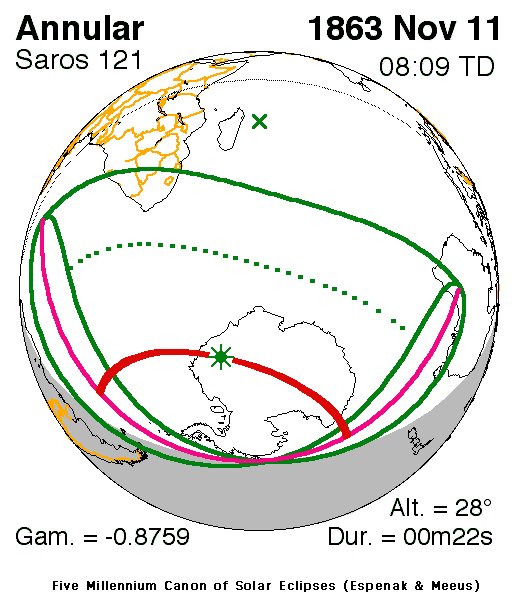
| Nature | Annular |
| Gamma | −0.876 |
| Magnitude | 0.9943 |
| Maximum eclipse | |
| Duration | 22 s (0 min 22 s) |
| Coordinates | 75°24′S 15°06′E / 75.4°S 15.1°E |
| Max. width of band | 42 km (26 mi) |
| Times (UTC) | |
| Greatest eclipse | 8:09:03 |
| References | |
| Saros | 121 (52 of 71) |
| Catalog # (SE5000) | 9196 |
An annular solar eclipse occurred at the Moon's ascending node of orbit on Wednesday, November 11, 1863, with a magnitude of 0.9943. A solar eclipse occurs when the Moon passes between Earth and the Sun, thereby totally or partly obscuring the image of the Sun for a viewer on Earth. An annular solar eclipse occurs when the Moon's apparent diameter is smaller than the Sun's, blocking most of the Sun's light and causing the Sun to look like an annulus (ring). An annular eclipse appears as a partial eclipse over a region of the Earth thousands of kilometres wide. Occurring about 3.7 days before perigee (on November 15, 1863, at 12:30 UTC), the Moon's apparent diameter was larger.[1]
The path of annularity was visible from parts of Antarctica. A partial solar eclipse was also visible for parts of Southern Africa, Antarctica, and southern Australia.
Description
[edit]The eclipse took place in Africa including Namacqualand (then also South-West Africa, now Namibia), Bechuanaland (now Botswana) South Africa (which included the British colonies and the Boer states at the time), Basutoland (parts now Lesotho), Zululand (now part of KwaZulu-Natal, South Africa) and portions of Swaziland. The rest took place in the South Atlantic up to hundreds of kilometers (or miles) offshore from South America except for Tierra del Fuego which was included and included the islands, the Indian Ocean, all of Antarctica which many areas had a 24-hour daylight that time, the southernmost areas of Australia along with Tasmania and the southernmost parts of the Pacific Ocean.
As the moon moved towards the left on Earth in Africa, at the peninsular portion, it was seen as it was moved towards the bottom right, then right then top as the axis spun at around the 71st parallel south.
The eclipse started at sunrise close to South America and finished at sunset in Australia, 70% at the Antarctic shores at the Indian Ocean.
It showed up to 30% obscuration in the area of Cape Town and Cape Agulhas up to 99% inside the maximum width of band. The greatest eclipse was in the middle of Antarctica east of the Prime Meridian at 75.4 S, 15.1 E at 8:09 UTC (9:09 AM local time) and lasted for 22 seconds, the maximum width of band was only 42 km (26 miles), the view around it was partly dark even inside the clouds.[2]
The subsolar marking was east of Madagascar and close to the Mascarene Islands.
Eclipse details
[edit]Shown below are two tables displaying details about this particular solar eclipse. The first table outlines times at which the moon's penumbra or umbra attains the specific parameter, and the second table describes various other parameters pertaining to this eclipse.[3]
| Event | Time (UTC) |
|---|---|
| First Penumbral External Contact | 1863 November 11 at 05:50:20.4 UTC |
| First Umbral External Contact | 1863 November 11 at 07:16:14.8 UTC |
| First Central Line | 1863 November 11 at 07:17:07.6 UTC |
| Greatest Duration | 1863 November 11 at 07:17:07.6 UTC |
| First Umbral Internal Contact | 1863 November 11 at 07:18:01.0 UTC |
| Ecliptic Conjunction | 1863 November 11 at 07:59:38.2 UTC |
| Greatest Eclipse | 1863 November 11 at 08:09:02.9 UTC |
| Equatorial Conjunction | 1863 November 11 at 08:26:28.2 UTC |
| Last Umbral Internal Contact | 1863 November 11 at 08:59:54.9 UTC |
| Last Central Line | 1863 November 11 at 09:00:45.6 UTC |
| Last Umbral External Contact | 1863 November 11 at 09:01:35.7 UTC |
| Last Penumbral External Contact | 1863 November 11 at 10:27:32.0 UTC |
| Parameter | Value |
|---|---|
| Eclipse Magnitude | 0.99433 |
| Eclipse Obscuration | 0.98868 |
| Gamma | −0.87594 |
| Sun Right Ascension | 15h04m02.6s |
| Sun Declination | -17°20'12.6" |
| Sun Semi-Diameter | 16'09.8" |
| Sun Equatorial Horizontal Parallax | 08.9" |
| Moon Right Ascension | 15h03m23.8s |
| Moon Declination | -18°10'30.9" |
| Moon Semi-Diameter | 15'57.1" |
| Moon Equatorial Horizontal Parallax | 0°58'32.5" |
| ΔT | 6.8 s |
Eclipse season
[edit]This eclipse is part of an eclipse season, a period, roughly every six months, when eclipses occur. Only two (or occasionally three) eclipse seasons occur each year, and each season lasts about 35 days and repeats just short of six months (173 days) later; thus two full eclipse seasons always occur each year. Either two or three eclipses happen each eclipse season. In the sequence below, each eclipse is separated by a fortnight.
| November 11 Ascending node (new moon) |
November 25 Descending node (full moon) |
|---|---|
|
|
| Annular solar eclipse Solar Saros 121 |
Partial lunar eclipse Lunar Saros 133 |
Related eclipses
[edit]Eclipses in 1863
[edit]- A partial solar eclipse on May 17.
- A total lunar eclipse on June 1.
- An annular solar eclipse on November 11.
- A partial lunar eclipse on November 25.
Metonic
[edit]- Preceded by: Solar eclipse of January 23, 1860
- Followed by: Solar eclipse of August 29, 1867
Tzolkinex
[edit]- Preceded by: Solar eclipse of September 29, 1856
- Followed by: Solar eclipse of December 22, 1870
Half-Saros
[edit]- Preceded by: Lunar eclipse of November 4, 1854
- Followed by: Lunar eclipse of November 15, 1872
Tritos
[edit]- Preceded by: Solar eclipse of December 11, 1852
- Followed by: Solar eclipse of October 10, 1874
Solar Saros 121
[edit]- Preceded by: Solar eclipse of October 30, 1845
- Followed by: Solar eclipse of November 21, 1881
Inex
[edit]- Preceded by: Solar eclipse of November 30, 1834
- Followed by: Solar eclipse of October 20, 1892
Triad
[edit]- Preceded by: Solar eclipse of January 9, 1777
- Followed by: Solar eclipse of September 12, 1950
Solar eclipses of 1862–1866
[edit]This eclipse is a member of a semester series. An eclipse in a semester series of solar eclipses repeats approximately every 177 days and 4 hours (a semester) at alternating nodes of the Moon's orbit.[4]
The partial solar eclipses on June 27, 1862 and December 21, 1862 occur in the previous lunar year eclipse set, and the partial solar eclipse on March 16, 1866 occurs in the next lunar year eclipse set.
| Solar eclipse series sets from 1862 to 1866 | ||||||
|---|---|---|---|---|---|---|
| Ascending node | Descending node | |||||
| Saros | Map | Gamma | Saros | Map | Gamma | |
| 111 | November 21, 1862 Partial |
−1.5052 | 116 | May 17, 1863 Partial |
1.0627 | |
| 121 | November 11, 1863 Annular |
−0.8760 | 126 | May 6, 1864 Hybrid |
0.2622 | |
| 131 | October 30, 1864 Annular |
−0.1816 | 136 | April 25, 1865 Total |
−0.4826 | |
| 141 | October 19, 1865 Annular |
0.5366 | 146 | April 15, 1866 Partial |
−1.1846 | |
| 151 | October 8, 1866 Partial |
1.2296 | ||||
Saros 121
[edit]This eclipse is a part of Saros series 121, repeating every 18 years, 11 days, and containing 71 events. The series started with a partial solar eclipse on April 25, 944 AD. It contains total eclipses from July 10, 1070 through October 9, 1809; hybrid eclipses on October 20, 1827 and October 30, 1845; and annular eclipses from November 11, 1863 through February 28, 2044. The series ends at member 71 as a partial eclipse on June 7, 2206. Its eclipses are tabulated in three columns; every third eclipse in the same column is one exeligmos apart, so they all cast shadows over approximately the same parts of the Earth.
The longest duration of totality was produced by member 39 at 6 minutes, 20 seconds on June 21, 1629, and the longest duration of annularity will be produced by member 62 at 2 minutes, 27 seconds on February 28, 2044. All eclipses in this series occur at the Moon’s ascending node of orbit.[5]
| Series members 49–70 occur between 1801 and 2200: | ||
|---|---|---|
| 49 | 50 | 51 |
 October 9, 1809 |
 October 20, 1827 |
 October 30, 1845 |
| 52 | 53 | 54 |
November 11, 1863 |
 November 21, 1881 |
 December 3, 1899 |
| 55 | 56 | 57 |
 December 14, 1917 |
 December 25, 1935 |
 January 5, 1954 |
| 58 | 59 | 60 |
 January 16, 1972 |
 January 26, 1990 |
 February 7, 2008 |
| 61 | 62 | 63 |
 February 17, 2026 |
 February 28, 2044 |
 March 11, 2062 |
| 64 | 65 | 66 |
 March 21, 2080 |
 April 1, 2098 |
 April 13, 2116 |
| 67 | 68 | 69 |
 April 24, 2134 |
 May 4, 2152 |
 May 16, 2170 |
| 70 | ||
 May 26, 2188 | ||
Metonic series
[edit]The metonic series repeats eclipses every 19 years (6939.69 days), lasting about 5 cycles. Eclipses occur in nearly the same calendar date. In addition, the octon subseries repeats 1/5 of that or every 3.8 years (1387.94 days). All eclipses in this table occur at the Moon's ascending node.
| 25 eclipse events between April 5, 1837 and June 17, 1928 | ||||
|---|---|---|---|---|
| April 5–6 | January 22–23 | November 10–11 | August 28–30 | June 17–18 |
| 107 | 109 | 111 | 113 | 115 |
 April 5, 1837 |
 January 22, 1841 |
 November 10, 1844 |
 August 28, 1848 |
 June 17, 1852 |
| 117 | 119 | 121 | 123 | 125 |
 April 5, 1856 |
 January 23, 1860 |
November 11, 1863 |
 August 29, 1867 |
 June 18, 1871 |
| 127 | 129 | 131 | 133 | 135 |
 April 6, 1875 |
 January 22, 1879 |
 November 10, 1882 |
 August 29, 1886 |
 June 17, 1890 |
| 137 | 139 | 141 | 143 | 145 |
 April 6, 1894 |
 January 22, 1898 |
 November 11, 1901 |
 August 30, 1905 |
 June 17, 1909 |
| 147 | 149 | 151 | 153 | 155 |
 April 6, 1913 |
 January 23, 1917 |
 November 10, 1920 |
 August 30, 1924 |
 June 17, 1928 |
Tritos series
[edit]This eclipse is a part of a tritos cycle, repeating at alternating nodes every 135 synodic months (≈ 3986.63 days, or 11 years minus 1 month). Their appearance and longitude are irregular due to a lack of synchronization with the anomalistic month (period of perigee), but groupings of 3 tritos cycles (≈ 33 years minus 3 months) come close (≈ 434.044 anomalistic months), so eclipses are similar in these groupings.
| Series members between 1801 and 2200 | ||||
|---|---|---|---|---|
 April 14, 1809 (Saros 116) |
 March 14, 1820 (Saros 117) |
 February 12, 1831 (Saros 118) |
 January 11, 1842 (Saros 119) |
 December 11, 1852 (Saros 120) |
November 11, 1863 (Saros 121) |
 October 10, 1874 (Saros 122) |
 September 8, 1885 (Saros 123) |
 August 9, 1896 (Saros 124) |
 July 10, 1907 (Saros 125) |
 June 8, 1918 (Saros 126) |
 May 9, 1929 (Saros 127) |
 April 7, 1940 (Saros 128) |
 March 7, 1951 (Saros 129) |
 February 5, 1962 (Saros 130) |
 January 4, 1973 (Saros 131) |
 December 4, 1983 (Saros 132) |
 November 3, 1994 (Saros 133) |
 October 3, 2005 (Saros 134) |
 September 1, 2016 (Saros 135) |
 August 2, 2027 (Saros 136) |
 July 2, 2038 (Saros 137) |
 May 31, 2049 (Saros 138) |
 April 30, 2060 (Saros 139) |
 March 31, 2071 (Saros 140) |
 February 27, 2082 (Saros 141) |
 January 27, 2093 (Saros 142) |
 December 29, 2103 (Saros 143) |
 November 27, 2114 (Saros 144) |
 October 26, 2125 (Saros 145) |
 September 26, 2136 (Saros 146) |
 August 26, 2147 (Saros 147) |
 July 25, 2158 (Saros 148) |
 June 25, 2169 (Saros 149) |
 May 24, 2180 (Saros 150) |
 April 23, 2191 (Saros 151) | ||||
Inex series
[edit]This eclipse is a part of the long period inex cycle, repeating at alternating nodes, every 358 synodic months (≈ 10,571.95 days, or 29 years minus 20 days). Their appearance and longitude are irregular due to a lack of synchronization with the anomalistic month (period of perigee). However, groupings of 3 inex cycles (≈ 87 years minus 2 months) comes close (≈ 1,151.02 anomalistic months), so eclipses are similar in these groupings.
| Series members between 1801 and 2200 | ||
|---|---|---|
 December 21, 1805 (Saros 119) |
 November 30, 1834 (Saros 120) |
November 11, 1863 (Saros 121) |
 October 20, 1892 (Saros 122) |
 October 1, 1921 (Saros 123) |
 September 12, 1950 (Saros 124) |
 August 22, 1979 (Saros 125) |
 August 1, 2008 (Saros 126) |
 July 13, 2037 (Saros 127) |
 June 22, 2066 (Saros 128) |
 June 2, 2095 (Saros 129) |
 May 14, 2124 (Saros 130) |
 April 23, 2153 (Saros 131) |
 April 3, 2182 (Saros 132) |
|
See also
[edit]References
[edit]- ^ "Moon Distances for London, United Kingdom, England". timeanddate. Retrieved 4 September 2024.
- ^ "Solar eclipse of June 27, 1862". NASA. Retrieved March 22, 2017.
- ^ "Annular Solar Eclipse of 1863 Nov 11". EclipseWise.com. Retrieved 4 September 2024.
- ^ van Gent, R.H. "Solar- and Lunar-Eclipse Predictions from Antiquity to the Present". A Catalogue of Eclipse Cycles. Utrecht University. Retrieved 6 October 2018.
- ^ "NASA - Catalog of Solar Eclipses of Saros 121". eclipse.gsfc.nasa.gov.
.jpg)

