
Talk:Control of cities during the Syrian civil war/Archive 20
| This is an archive of past discussions. Do not edit the contents of this page. If you wish to start a new discussion or revive an old one, please do so on the current talk page. |
| Archive 15 | ← | Archive 18 | Archive 19 | Archive 20 | Archive 21 | Archive 22 | → | Archive 25 |
Regime Controll industrial city in northern Aleppo
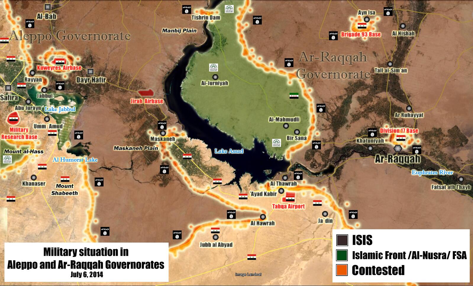
Several reports from different sources, including pro opposition sources, indicate that the SAA has taken controll of the industrial city http://www.syria-news.com/readnews.php?sy_seq=171674 (seems neutral) http://www.alquds.co.uk/?p=188474 (pro opposition) http://www.al-akhbar.com/node/209919 (pro Gov) And the last source contain some interesing updates of the situation in northern Aleppo Ali bachir (talk) 07:05, 4 July 2014 (UTC)
- Here more the confirmations from the pro opposition sources Syria: directAksalser also confirmation from a reliable sourceGlobal PostZee News and here confirmation from SOHR Hanibal911 (talk) 09:34, 4 July 2014 (UTC)
more source pro opp: https://twitter.com/IF_Focus/status/484791621079162880 and sana (pro gov) :http://www.sana.sy/en/?p=5441 .Update the map — Preceding unsigned comment added by 5.46.60.183 (talk) 16:15, 4 July 2014 (UTC)
Here is the Syria TV report and pro insurgent Cedric Labrousse Twitter — Preceding unsigned comment added by LogFTW (talk • contribs) 16:23, 4 July 2014 (UTC) --LogFTW (talk) 16:27, 4 July 2014 (UTC)
Confirmation of this by pro-opp SOHR,Kafar Sghir and Al Rahmaneyya captured by the army too https://www.facebook.com/syriahroe/posts/550661815042161(talk)18:41 4 July 2014 (UTC) — Preceding unsigned comment added by 95.238.112.55 (talk)
+ pics from industrial city (shows fully under amry control) phase 1: https://www.facebook.com/Shady.Hulwe.Reporter.page3/posts/339774319505815 phase 2: https://www.facebook.com/Shady.Hulwe.Reporter.page3/posts/339775782839002 phase 3: https://www.facebook.com/Shady.Hulwe.Reporter.page3/posts/339785409504706 phase 4: https://www.facebook.com/Shady.Hulwe.Reporter.page3/posts/339790386170875 — Preceding unsigned comment added by 5.46.91.40 (talk) 17:04, 4 July 2014 (UTC)
Here is the SANA official Video Report--LogFTW (talk) 17:09, 4 July 2014 (UTC)
Lebanese News Agency Al Manar and another confirmation from Chinese News Agency — Preceding unsigned comment added by LogFTW (talk • contribs) 17:38, 4 July 2014 (UTC) --LogFTW (talk) 19:43, 4 July 2014 (UTC)
Another source confirming the capture of the whole industrial zone [1]. EkoGraf (talk) 01:01, 4 July 2014 (UTC)
Confirmation about the whole of the industrial city coming under government control from the heavily pro-opp source of Cedric Labrousse [2]. EkoGraf (talk) 18:36, 4 July 2014 (UTC)
According to Pro Insurgent SOHR I think these are the two towns who captured the Government here is Rahmaniyah and here is Kafr Saghir--LogFTW (talk) 20:47, 4 July 2014 (UTC)
The Army has captured Al Naseryyi [3], near Tall Shair, and is advancing towards the infantry school now, also the Army has come within artillery range of Halisah and Fafin. You should double-check the translation of the names before making the changes though. EkoGraf (talk) 21:56, 4 July 2014 (UTC)
Why is Damascus and town of Maydaa never updated?
Many reports coming in of this town of Maydaa in rebel damascus pocket as being under IS. It looks like clashes are occurring. WHy is this part of the map never updated? This article says: "Other enemies have mobilized against the Islamic State. East of Damascus, rebels from the Saudi-backed Islamic Army have been fighting to drive it from the town of Maydaa in the Ghouta area." http://www.reuters.com/article/2014/07/03/us-syria-crisis-state-insight-idUSKBN0F81D420140703 — Preceding unsigned comment added by 169.231.67.15 (talk) 16:33, 3 July 2014 (UTC)
Reports now coming in ISIS has been pushed out of the town. EkoGraf (talk) 17:24, 3 July 2014 (UTC)
Al Maliha as well is been reported to be in SAA hands. — Preceding unsigned comment added by Archinovista (talk • contribs) 08:30, 4 July 2014 (UTC)
This place is in ISIS Hands now called IS (Islamic State) http://www.syrianperspective.com/2014/07/syrian-army-liberates-maydaah-in-the-ghouta.html
Damascus map should have some updated — Preceding unsigned comment added by LogFTW (talk • contribs) 01:39, 5 July 2014 (UTC)
Editor Boredwhytekid need to learn how to link specific Facebook post
Ok I'm a crap editor and my English lacks but the User Boredwhytekid is doing many edition on this map using the SOHR as source, in my personal opinion SOHR are not credible at all in the report between the Islamic State and Syrian Atmy because the SOHR "Activits Network" working mostly in West / Gulf monarchies backed insurgents (Al Qaeda / Islamic Front / FSA) .
Anyway the point is he link all the facebook SOHR page we can't read the entire all the facebook SOHR page he need to Learn how link specific facebook posts for know about what specific situations these anti government activists they are meaning reports if he just link all the facebook SOHR page I assume there are not a source...
Is well know the SOHR is basically anti government and support all type of armed groups / Force who decided fight / attack the Syrian troops however it's used many times as source I have nothing against that, but many times we usually confirmed the SOHR with third sources after discussion on here talk page. --LogFTW (talk) 02:05, 6 July 2014 (UTC)
Oops. My bad on not linking a specific post. But, the SOHR discussion is long over - it can be used as a source. https://www.facebook.com/syriahroe/posts/550836608358015 https://www.facebook.com/syriahroe/posts/550572238384452 There are two SOHR posts in the last 24 hours stating Sheikh Hadid is contested. https://www.facebook.com/syriahroe/posts/551125528329123 There's one for Abu Hamam. https://www.facebook.com/syriahroe/posts/550571231717886 And there's the 17th division. Boredwhytekid (talk) 15:01, 6 July 2014 (UTC)
Tabqa Raqqa airbase no besiege
The Editor Boredwhytekid putTabqa Raqqa airbase under siege, this was under siege during part from year 2013 but the siege were lifted around January 2014 when the Infighting between the ISIS and others insurgent become more violents In January the Al Manar Lebanese TV doing a Report inside the Tabqa airport
Latter according to [this pro insurgent source http://tahrirsouri.com/2014/05/14/isis-advances-on-the-rebels-of-ar-raqqa-while-the-regime-attempts-to-rut-a-path-to-the-tabqa-airbase/] the army captured several villages near the airport these small advances were confirmed by pro regime map and was confirmed by the SOHR too.
Probability the pro insurgent SOHR reported shelling away against the Tabqa airport but it no mean a Siege so Israel shelling several times Syrian Army position in some areas on Syrian held Golan from Israeli held Golan and nobody here planing draw here the Brigade 93 besiege by Israeli troops..
For made the siege again the Insurgents (In this case the Islamic State insurgents) need to retake these villages near the airport captured by the Army in May 2014 — Preceding unsigned comment added by LogFTW (talk • contribs) 03:29, 6 July 2014 (UTC) --LogFTW (talk) 03:31, 6 July 2014 (UTC)
Thus far I cannot relocate the SOHR post that stated Tabqa is besieged, so this edit I will not revert. Division 17 and Sheikh Hadid, I replaced - sources linked above. Funny how "shelling away" is enough to put a red circle around anything, but not enough to put a circle around anything red.. Boredwhytekid (talk) 15:22, 6 July 2014 (UTC)
A new (pro-SAA) map: https://pbs.twimg.com/media/Br2chcMCcAAvR50.jpg:large Maybe it is of use. 77.161.206.160 (talk) 15:33, 6 July 2014 (UTC)
Raqqa brigade 93 not besiege.
Based on this pro insurgent map from April 30 2014 and this another pro insurgent map from May 11 2014 is visible how the situation no change in the zone near the Brigade 93, same case with this recent pro government map yes access is only possible via Air landing helicopter but Hasahka region is in a similar Situation with a lot people living in Government held areas.
This map it's not about held territory this map is not about held territory it's called Cities and towns — Preceding unsigned comment added by LogFTW (talk • contribs) 02:46, 7 July 2014 (UTC) --LogFTW (talk) 02:51, 7 July 2014 (UTC)
All three of those maps show Brigade 93 surrounded - but, the situation HAS changed - in that the IS and gov't have actually started shooting at each other. And it's not the same as Hasakah, where there is relative calm/lack of fighting. To your "cities and towns" comment - if it's just cities and towns, why is Brigade 93 even on the map? lol Boredwhytekid (talk) 12:28, 7 July 2014 (UTC)
North of Aleppo
SYRIAN ARMY HAS ENTERED AL-RAHEEMA VILLAGE IN NORTHERN ALEPPO you can know about contested villages and zones in this source Read more at http://www.syrianperspective.com/2014/07/major-advances-in-aleppo.html#M7LChR2Q164QeUBi.9946.143.214.140 (talk) 08:03, 3 July 2014 (UTC)
- I'm sorry to disappoint you but we can not on the basis data of the pro government source to display of the army advances. Hanibal911 (talk) 08:44, 3 July 2014 (UTC)
Syriadirect is pro-opp, and its update from today also confirms gov't advances in the Sheikh Najjar district. Boredwhytekid (talk) 15:17, 3 July 2014 (UTC)
Yes, I just checked. Syriadirect (heavily pro-opp) news report for 3 July stated the Army has captured large swathes of the industrial city, especially industrial area 3. It also reported the Army is now advancing to capture the rest of the industrial zone. EkoGraf (talk) 15:31, 3 July 2014 (UTC)
Indeed. They cite http://www.aksalser.com/index.php?page=view_articles&id=50a1a3d5b1e787f5f4b4f560c4500163 also pro-opp Boredwhytekid (talk) 15:35, 3 July 2014 (UTC)
I agree with EkoGraf. Many reports say it's been taken by govt. forces. [bit.ly/1mXHHIc]
- Here the confirmation from the pro opposition source Syria: direct Hanibal911 (talk) 20:41, 3 July 2014 (UTC)
- Another source confirming the capture of the whole industrial zone [4]. EkoGraf (talk) 01:01, 4 July 2014 (UTC)
Pro-opp eaworldview is reporting that gov't seized Kifr Saghir town north of the Sheikh Najjar industrial region. http://eaworldview.com/2014/07/syria-daily-regime-continues-advance-near-aleppo/ Boredwhytekid (talk) 13:02, 7 July 2014 (UTC)
al Karamah, Raqqa
Is this a mis-identification? Or improper coordinates? I can't locate it on mapcarta or wikimapia, but on our map it's sitting practically on top of Fatsat ath Thayb http://wikimapia.org/#lang=en&lat=35.876060&lon=39.270630&z=13&m=b Boredwhytekid (talk) 19:43, 7 July 2014 (UTC)
- Here this town on this map.Al Karamah Hanibal911 (talk) 20:00, 7 July 2014 (UTC)
Ok, so looking at that next to wikimapia, they are one and the same place. I just added Fatsat ath Thayb per https://pbs.twimg.com/media/Br2chcMCcAAvR50.jpg:large. I have no clue which name is accurate - but we probably don't need both circles, so I will revert mine. Boredwhytekid (talk) 20:27, 7 July 2014 (UTC)
Mayda'a in Ghuta
The SAA got control of Mayda'a after heavy bombardment of ISIS troops there http://www.syrianperspective.com/2014/07/syrian-army-liberates-maydaah-in-the-ghouta.htmlMZarif (talk) 05:55, 5 July 2014 (UTC)
the source is clearly biased towards assad,so unreliable.Alhanuty (talk) 15:33, 5 July 2014 (UTC)
- The city of Maydaa under army control here confirmation from a reliable source.Reuters Hanibal911 (talk) 20:20, 5 July 2014 (UTC)
we need to change map of damascus, also to put 90 % of AL MLEHA to government, and 10% as contetsted (north part) — Preceding unsigned comment added by 94.102.233.227 (talk) 07:08, 7 July 2014 (UTC)
the map is very inaccurate,so the edit should be reverted,till a reliable map proves it,also,only pro-regime sources reported that,and also there was reports of fighting between Islamic front and ISIS,further refuting the government claim of its recapture,i recommend that the edit be reverted.Alhanuty (talk) 04:06, 8 July 2014 (UTC)
someone change damascus map again. pro rebel user stop changing maps!!!!! — Preceding unsigned comment added by 94.102.233.227 (talk) 06:38, 10 July 2014 (UTC)
That's all your contribution?
This map is PARTIALLY inaccurate yes it's but Most maps ALWAYS have severals mistakes is basically have a map 100& accurate this is one source you provide no sources for doing changes-
Both sources Reuters ans Syrian Perspective coincide 100%
If you want refuse this change need to provide a source if you have one source link it or stop to change the map without sources.
Assal al-Ward contested
SOHR reports https://www.facebook.com/syriahroe?ref=stream&fref=nf Boredwhytekid (talk) 16:02, 2 July 2014 (UTC)
- Source said that clashes took place in the wastelands of the city Assal al-Ward but not in the city. So that we need more information of the situation in the area. Also rebels have repeatedly claimed that all their attacks in the area by the tactics hit and retreated that would distract the army and to relieve the pressure of army in the region of Eastern Guta. Hanibal911 (talk) 16:46, 2 July 2014 (UTC)
Wastelands=outskirts then? In that case a green circle should indicate the rebel presence/clashes around the town. We really can't keep ignoring the fighting in Qalamoun..its disreputable to the map..Boredwhytekid (talk) 17:47, 2 July 2014 (UTC)
- I think that is not worth it to put a green circle around the city because Assal al-Ward not besieged by rebels and clashes in this area were night and there was no longer any details and as I have previously said it could just be a rebel attack on the military patrol from the territory near the Lebanese border where there are still pockets of resistance. Need more information. Hanibal911 (talk) 18:08, 2 July 2014 (UTC)
- Also, I think many will agree with me that for the greater correctness on this map we need a new icon which will mean that go clashes around the city. Hanibal911 (talk) 18:12, 2 July 2014 (UTC)
- I think that is not worth it to put a green circle around the city because Assal al-Ward not besieged by rebels and clashes in this area were night and there was no longer any details and as I have previously said it could just be a rebel attack on the military patrol from the territory near the Lebanese border where there are still pockets of resistance. Need more information. Hanibal911 (talk) 18:08, 2 July 2014 (UTC)
Is not worth it? If there are clashes in the outskirts, we put a circle - in lieu of a new icon, (I completely agree with you - we need a new icon!), that's how this map works. Most of the concentric circles on the map are not besieged - just fighting on the outskirts. Same applies to Assal al-Ward. Boredwhytekid (talk) 20:00, 2 July 2014 (UTC) Even SANA says there's fighting in the outskirts... http://www.sana.sy/en/?p=4231
The fights are in the west of the town near Lebanese border the town Assal al-Ward it's not surrounded / In conflict - before was reported insurgents surrender to Hezbollah inside Lebanon http://www.dailystar.com.lb/News/Lebanon-News/2014/Jun-21/261057-hezbollah-syrian-army-surround-lebanese-enclave.ashx#axzz35M3kZspD — Preceding unsigned comment added by LogFTW (talk • contribs) 00:10, 3 July 2014 (UTC)
There needs to be SOME indicator of the clashes. This map has ignored them/not shown the Qalamoun clashes for WEEKS. It's just not credible. How about a contested icon in the mountains between Assal al-Ward and the Lebanese border? Boredwhytekid (talk) 12:49, 3 July 2014 (UTC)
- A similar situation in many areas but the situation there is constantly changing and is extremely difficult to display it on this map. The only thing we need to do now is add a new icon that will display that go clashes around the city or village. Hanibal911 (talk) 13:06, 3 July 2014 (UTC)
We've got WEEKS of sources from all sides. http://www.dailystar.com.lb/News/Middle-East/2014/Jun-22/261107-syria-army-battle-rebels-in-key-damascus-foothills-tv.ashx#axzz35Yj7CDSI http://news.yahoo.com/iraqi-conflict-flares-syrian-rebels-regroup-lebanon-133644446.html http://www.albawaba.com/news/syria-qalamoun-585263. Even SANA has been reporting clashes in the mountains for weeks. We know exactly where they are occurring - from the outskirts of Assal al-Ward to the Lebanese border. If you guys are so against the concentric circle (which I understand, b/c it's not besieged), then ok, I will not place it again. But at least concede a contested symbol in the wilderness/mountain region - because we have plenty of sources, know the exact location, and it ups the credibility of the map.. Boredwhytekid (talk) 13:12, 3 July 2014 (UTC)
But nothing who you link suggests the Assal al-Ward (Inside the Town) is in conflict or surrounded just clashed near Lebanon who is close to the town but no inside the town.
Contested = Mean significant extensive clashed in significant places of the town surrounded Besiege = Place totally encircle, all access closed no access via ground
Lest see = Based in this Source is assumed the Army controlled the whole area because Tfail is inside Lebanon and town is not blocked on Lebanese side between in fact the way between Tfail (Lebanon) and Assal al-Ward is open.
In your first link are not mention about Assal al-Ward but talk about Tfail a Lebanese Town near the area and is clearly specific = On Saturday, a Lebanese security source told The Daily Star that the Syrian regime, backed by Hezbollah, had taken control of the Syrian territory surrounding the Lebanese village of Tfail. This reaffirm the West of Assal al-Ward is controlled by the Army.
Tfail is located east of Brital on a promontory of Lebanese territory surrounded on three sides by Syria’s Qalamoun region and has almost been completely isolated as a result of the conflict in the neighboring country.
In your second link same case not mention about Assal al-Ward it talk about Insurgents claim attack near Rankous post (Other town away from Assal al-Ward)
In your third link just said "Regime, rebels continue fighting in Qalamoun" this said the combats continue in Al Qalamoun area but no mention about Assal al-Ward.
No substantial evidences Assal al-Ward is total or partially Besiege / Contested - We no have a mode to draws insurgents in caves / Mountains. — Preceding unsigned comment added by LogFTW (talk • contribs) 16:00, 3 July 2014 (UTC)
- http://www.sana.sy/en/?p=4231 http://www.dailystar.com.lb/News/Lebanon-News/2014/Jun-18/260618-lebanese-families-flee-shelled-tfeil-toward-arsal.ashx#axzz36QERTE9B http://carnegieendowment.org/sada/2014/06/26/hezbollah-s-iraq-problems/hekr I mean, we could do this for days if you please. We all know there is fighting in that area. There has been for a month. We constantly use the concentric circle icon to depict fighting on the outskirts of towns - regardless of whether they are besieged or not. It HAS to be shown, otherwise this map is b/s and we are intentionally hiding the truth. I have no preference - no qualms about providing sources for Red, Lime, Black, or Yellow, as can be seen in the various edits I've made - my interest is accuracy. And no indication of rebel presence around Assal al-Ward is a straight lie. Boredwhytekid (talk) 16:11, 3 July 2014 (UTC)
The request is for make Assal al-Ward in conflict / Contested - besiege / surrounded. Assal al-Ward it's not in Assal al-Ward in conflict / Contested - besiege / surrounded.
All the sources linked suggest the town Assal al-Ward it's not in conflict / Contested - besiege / surrounded.
What I can do? That's who I'm reading. — Preceding unsigned comment added by LogFTW (talk • contribs) 16:49, 3 July 2014 (UTC) --LogFTW (talk) 16:52, 3 July 2014 (UTC)
But..that's not true. SANA says "outskirt of Assal al-Ward". DailyStar says "Free Syrian Army's attack three days ago IN (in!) Assal al-Ward". Carnegie says "around Assal al-Ward". Even discounting DailyStar's "in", we still have SANA pro-gov't and Carnegie pro-opp confirming clashes in the immediate environs - for which, on this map, we put a concentric circle. Boredwhytekid (talk) 17:09, 3 July 2014 (UTC)
This said In the outskirt of Assal al-Ward
Mean sporadic clashed near the town here is the official SANA Report on Video is very clear the place is not besiege / surrounded the insurgent no cut a single supply route to this place, they are using insurgency warfare planing small attack / ambush but are not able at the moment to make this place in conflict / Contested - besiege / surrounded. — Preceding unsigned comment added by LogFTW (talk • contribs) 17:29, 3 July 2014 (UTC)
The town is under government control Since May 2014 Syrian Alikhbaria TV Report, Syria TV Report andSAMA TV Report
Syria TV Report showing in June 19 this place stable and under government control same case with this Lebanon News Agency elnashra Video from June 21 showing the whole town stable under regime control and this another report dated in June 18 Alikhbaria TV showing the Syrian Refuges returning, this is a proof there in Assal al-Ward are not a Siege and roads are working. --LogFTW (talk) 17:55, 3 July 2014 (UTC)
Just low scale insurgency no substantial evidences for made Assal al-Ward conflict / Contested - besiege / surrounded in the future may be but not now.
Haha I'm done after this comment - now you're just being silly, you know we don't use youtube! Besides, the SANA article that I cited is more recent - June 25th. Boredwhytekid (talk) 18:07, 3 July 2014 (UTC)
These videos are not random you tube videos from irregulars groups these are official TV Reports from News agencies using professionals Journalists teams, Syria got three important TV Channels SAMA TV, Syria TV and Syrian News Channel, so these videos are counted as pro Government Sources no as random you tube videos because were made by professionals Journalists - I link a report from elnashra from Lebanon too
Finally here is again This is the official Report from SANA near Assal al-Ward.--LogFTW (talk) 18:30, 3 July 2014 (UTC)
Recent article about Qalamoun http://www.dailystar.com.lb/News/Lebanon-News/2014/Jul-08/263005-border-rebels-resist-hezbollah-regime.ashx#axzz36saWUB14 Boredwhytekid (talk) 12:33, 8 July 2014 (UTC)
Northern Aleppo, continued
This site - Moqbila - http://wikimapia.org/#lang=en&lat=36.288383&lon=37.305399&z=16&m=b and http://mapcarta.com/ was taken by the SAA per http://news.yahoo.com/syrian-army-tries-choke-off-rebels-aleppo-165907760.html and http://abcnews.go.com/International/wireStory/syrian-opposition-elect-president-24442506 and for good measure http://www.saudigazette.com.sa/index.cfm?method=home.regcon&contentid=20140708210799 (they're all the same report essentially.. just figured I'd throw 3 up) Boredwhytekid (talk) 13:43, 8 July 2014 (UTC)
Infantry college/ school to north of Aleppo city
Government control in the northern part of the Aleppo map needs to be extended northward. Telegraph newspaper confirms that SAA is assaulting the "infantry school" which you can see right above Aleppo: http://www.telegraph.co.uk/news/worldnews/middleeast/syria/10954499/Assad-forces-surrounding-Aleppo-Syrian-opposition-warns.html Pro-government website claims that SAA has fully captured the infantry college/school: http://www.syrianperspective.com/2014/07/syrian-army-crushes-terrorists-in-aleppo-liberates-shaykh-najjaar.html — Preceding unsigned comment added by 169.231.115.81 (talk) 21:13, 8 July 2014 (UTC)
Proposed New Icon
![]() - to be placed as a concentric circle around a town/village where fighting is occurring on the outskirts or in the vicinity. (An example would be Assal al-Ward or Kfar Laha). If adopted - my understanding is that - this will limit the use of red/lime/black/yellow concentric circles to situations where an actual siege is in place. (An example would be Nubl or al Wa'ar). Boredwhytekid (talk) 18:14, 7 July 2014 (UTC)
- to be placed as a concentric circle around a town/village where fighting is occurring on the outskirts or in the vicinity. (An example would be Assal al-Ward or Kfar Laha). If adopted - my understanding is that - this will limit the use of red/lime/black/yellow concentric circles to situations where an actual siege is in place. (An example would be Nubl or al Wa'ar). Boredwhytekid (talk) 18:14, 7 July 2014 (UTC)
- I support this idea! Hanibal911 (talk) 19:15, 7 July 2014 (UTC)
- I would support a new icon, but I really don't think creating a new color dot would be the clearest solution. The best solution was proposed by Andre 437, at the very top of this talk page, under the "Roads" discussion. He proposed making a quarter circle concentric circle icon to show that there was military pressure from one direction, but that the location was not under siege. (There would need to be quarter pie icons representing each direction, and the color of each faction. These icons could easily be added together to show pressure from multiple directions.) This solution is visually MUCH more intuitive, than having another color icon. It also conveys much more information. Maybe Andre 437 (do you still follow this page?) or someone else could make that icon. Hulahoop122 (talk) 20:14, 7 July 2014 (UTC)
There's a thought. Anyone else? Or, any savvy editor wanna introduce such a code? Boredwhytekid (talk) 20:17, 7 July 2014 (UTC)
- I just left a note on Andre437's talk page. He created from scratch the animated conflict icons that we use, so he would definitely have the skills to do it. Whether he still has the time and interest is another question.Hulahoop122 (talk) 20:43, 7 July 2014 (UTC)
- Thanks for leaving me a note :) (WP emailed me)
- Sure I would like to make these new icons. I've been busy lately, but will make time for them.
- My idea was to have semicircles oriented in 8 directions (4 cardinal points + those halfway between, that is N, NE, E, SE, S, SW, W, and NW).
- (N would be the semicircle with the centre facing north, meaning the arc W-NW-N-NE-E.)
- The thought was that we could have an idea in what directions are unfriendly and friendly forces, but it is not likely more than a general idea.
- It will take a little experimenting to find out exactly how to make the icons (like the last set), but I have no doubt I can do them.
- For the caption we could put one of each colour (red/green/yellow/blank) together and say something like "front against forces corresponding to the colour". With the dot of one colour and the semicircle of the other, it should be obvious.
- As before, I'm open to suggestions :) André437 (talk) 02:40, 9 July 2014 (UTC)
Ain Issa
User:HCPUNXKID added info from NYT about Ain Issa being conquered by IS, but I've not found a single tother source besides a mention on a map by NYT. Do you think it's credible?--195.168.209.253 (talk) 19:02, 7 July 2014 (UTC)
- The ISIS had controlled Ain Issa for quite a while, after evicting the rebels from around the nearby regime base 93 back in late January or February, if I remember correctly.
- The regime forces subsequently came out from the base to take the town, since the ISIS was no longer besieging the base.
- That article is just a general overview of the situation. (Evicting the rebels from the town, and other ISIS advances in Syria, at the expense of the rebels, and subsequently in Iraq.)
- Not sure that it would be reliable to say that the regime no longer controls the town. André437 (talk) 03:04, 9 July 2014 (UTC)
Semi-protected edit request on 9 July 2014
This edit request to Template:Syrian Civil War detailed map has been answered. Set the |answered= or |ans= parameter to no to reactivate your request. |
Two red circles at the same position, first as al Sheikh Hadid, and the second as Al-Sheikh Hadeid. 87.117.178.100 (talk) 10:38, 9 July 2014 (UTC)
 Done
Done
ISIS advances around Ayn al-Arab (Kobane)
SOHR has reported [5] that ISIS has captured three village east of Ayn al-Arab today and another two west of it six days ago. Please add them all to the map. Thank you! EkoGraf (talk) 16:38, 9 July 2014 (UTC)
al-Talae’ military camp
Has anyone been able to locate this? It's the site of the air raid reported today that allegedly killed 20+ IS members. http://www.albawaba.com/news/syria-isis-589230 https://www.facebook.com/syriahroe/posts/552828381492171 http://dailystar.com.lb/News/Middle-East/2014/Jul-09/263275-syria-air-raids-kill-20-islamic-state-jihadists.ashx#axzz36sROPPxi. The SOHR post says it's near al-Fakhikha village, which I could not find either. But I did find this article - https://www.google.com/?gws_rd=ssl#q=+al-Fakhikha+ - which indicates that al-Fakhikha is a fishing village, so it must be next to one of the rivers.. Boredwhytekid (talk) 17:27, 9 July 2014 (UTC)
al-Tarraf and al-Duhman checkpoints in Idlib
SOHR - https://www.facebook.com/syriahroe/posts/552921661482843 eaworldview (pro-op, but provides the video evidence too) - http://eaworldview.com/2014/07/syria-daily-insurgent-gains-northwest-southwest/ Boredwhytekid (talk) 15:39, 10 July 2014 (UTC)
Rebel presense in Khatab, Hama (Khitab on this map)
Daily Star LB and Al Bawaba citing SOHR http://www.dailystar.com.lb/News/Middle-East/2014/Jul-09/263223-syria-rebels-execute-14-in-hama-village-activist.ashx#axzz36qzFoH2K http://www.albawaba.com/news/syria-war-589176 https://www.facebook.com/syriahroe/posts/552664134841929. Doesn't say they occupied, doesn't say they are still there - but apparently they can walk in completely uncontested. Personally I seriously doubt that they stayed, as Khatab/Khitab is a ways behind gov't lines. That being said, how shall we indicate this? Obviously they can march into town unmolested.. Boredwhytekid (talk) 13:31, 9 July 2014 (UTC)
- We have the same situation with the city of Raqqa. The Syrian government’s secret cells in al-Raqqa.Al Akhbar Generally during the war, there are cases when the rebels or government groups can to penetrate into the city controlled by their opponents. And also three days ago SOHR reported that the military carried out raids and arrests in the city Khattab in search of rebels.SOHR Hanibal911 (talk) 16:34, 9 July 2014 (UTC)
- No change. Yes they went through the village on a rampage, but no evidence they stayed after they were finished. EkoGraf (talk) 16:38, 9 July 2014 (UTC)
So, if both sides are raiding it, neither side is stationed there, right? Is there a source citing gov't occupation of the village? (there definitely is not one for the rebels) Boredwhytekid (talk) 16:53, 9 July 2014 (UTC)
Difference between a regular army and an insurgent (raiding force). Besides, the village is within government territory. EkoGraf (talk) 14:59, 10 July 2014 (UTC)
- Now the town is under control of the Syrian army and now military searching some people who could cooperate with the rebels. SOHR said that the regime forces and their militiamen stormed the town of Khattab and carried out a raid and arrest of some people.SOHR Hanibal911 (talk) 17:47, 10 July 2014 (UTC)
Qalamoun region
This edit request to Template:Syrian Civil War detailed map has been answered. Set the |answered= or |ans= parameter to no to reactivate your request. |
Maybe you should add a contested circle in this region since there are at least 1000 rebels still fighting in this area, especially north to Al Ward. capturedCheckpoint AlQara video video2 SomeMap twitter twitter2 31.176.248.251 (talk) 22:20, 23 June 2014 (UTC) http://www.albawaba.com/news/syria-qalamoun-585263 http://www.dailystar.com.lb/News/Middle-East/2014/Jun-22/261107-syria-army-battle-rebels-in-key-damascus-foothills-tv.ashx#axzz35Yj7CDSI — Preceding unsigned comment added by Boredwhytekid (talk • contribs) 12:32, 24 June 2014 (UTC) http://news.yahoo.com/iraqi-conflict-flares-syrian-rebels-regroup-lebanon-133644446.html Boredwhytekid (talk) 14:32, 24 June 2014 (UTC)
At this point it makes no sense because at the moment in the area continues operation is the Syrian troops to aimed at containing and destroying remaining rebels in the area. Also Lebanese security source told that the Syrian regime, backed by Hezbollah, had taken control of the Syrian territory surrounding the Lebanese village of Tfail. Tfail is located east of Brital on a promontory of Lebanese territory surrounded on three sides by Syria’s Qalamoun region and has almost been completely isolated as a result of the conflict in the neighboring country. Some 70 rebel fighters surrendered to the Syrian army and handed over their arms.source Also the Hezbollah fighters entered Tfail in search of opposition fighters reportedly seeking refuge in the village.source Government troops launched an assault on the foothills of the Qalamoun mountains and had captured some hills overlooking the Rankous plain and cut the route used by rebels to periodically return to the region.source And you need to know that amateur videos from YouTube are not used as sources for map editing. Also in you source that Rebels said “We are using hit-and-run tactics now to wear down the enemy in Qalamoun and relieve pressure on other fronts such as Mleiha,” says Abu Zeid, a unit leader in the moderate rebel Muatassim Billah Brigade, referring to a besieged rebel-held town east of Damascus. “We hit two or three positions over a couple of days, then we retreat back into Lebanon.” It's just the partisan attack on military columns and army checkpoints that would reduce the army pressure in other areas. Hanibal911 (talk) 14:49, 24 June 2014 (UTC)
- Also pro rebel source confirmed three days ago that the Syrian forces and their allies control the area around the towns and villages in the Qalamoun and rebel positions concentrated near the Lebanese border in the mountains. And messages from the pro rebel source confirm that the army push to the rebel positions forcing them to retreat to the territory of Lebanon.here Hanibal911 (talk) 15:16, 24 June 2014 (UTC)
It's unfortunate that we don't have any icons to properly display this situation. I mean, anyone following the conflict knows that the rebels are in the mountains, and that clashes are ongoing; but b/c they don't possess any of the towns, our map shows the area as completely government held. And that is, well, not true. Perhaps colored shading would be useful here and in other areas where the situation is unclear and information is not forthcoming. Boredwhytekid (talk) 15:26, 24 June 2014 (UTC)
- I also think that we need a new icon which will mark that clashes are around the city but not in the city . Because when we mark a city of red circle and put around the green circle, this should mean that the city or village under the control of the army but under siege the rebels and also when we put a red circle around the green, this should mean that the city under rebel control but under siege the army. I hope that many editors agree with me in this issue! Hanibal911 (talk) 16:08, 24 June 2014 (UTC)
Also they shot down a regime SAA fighter jet video — Preceding unsigned comment added by 92.36.214.125 (talk) 21:16, 24 June 2014 (UTC)
- You probably dont know but we do not use as sources of amateur video because not possible to check when it was filmed. Hanibal911 (talk) 07:59, 25 June 2014 (UTC)
 Not done: please establish a consensus for this alteration before using the
 {{edit semi-protected}}template. There's currently no consensus. Please continue discussing and if a consensus is reached feel free to reactivate this request. — {{U|Technical 13}} (e • t • c) 17:06, 8 July 2014 (UTC)
https://www.facebook.com/syriahroe/posts/553626464745696 — Preceding unsigned comment added by Boredwhytekid (talk • contribs) 12:56, 11 July 2014 (UTC)
- Your source said that the warplanes raided on a farm near the town of Rankus and dropped a bomb in the area of Zabadani. But no reports of fighting in the area and reports of air strikes does not mean that in there are fights. Army can use aviation to destroy the rebels hiding in the area, and that would prevent the entry of rebel groups to this cities. We need more data from other sources. Hanibal911 (talk) 13:27, 11 July 2014 (UTC)
"ON Zabadani". Probably just the outskirts though - I am not for changing the status at all at this time. Boredwhytekid (talk) 14:06, 11 July 2014 (UTC)
Lahaya, Hama
SOHR says fighting is occurring "around" the village. https://www.facebook.com/syriahroe/posts/553621638079512 It's not on our map (b/c it's tiny and we don't have a source for who controls it). However, if you check it out on wikimapia http://wikimapia.org/#lang=en&lat=35.329551&lon=36.709614&z=16&m=b there's a Lahaya checkpoint right near the village. I'm betting that's where the clashes are. I propose adding the checkpoint in red, and putting a green semi-circle to the north to indicate the clashes. Boredwhytekid (talk) 14:04, 11 July 2014 (UTC) SOHR talk explicitly about the village http://wikimapia.org/#lang=en&lat=35.335293&lon=36.683693&z=12&m=b therefore we should make the village red with green circle. It is on the frontline according to the other known positions. Paolowalter (talk) 14:38, 11 July 2014 (UTC)
http://www.presstv.ir/detail/2014/07/23/372418/syria-army-blows-up-militant-headquarters/
Semi-protected edit request on 10 July 2014
This edit request to Template:Syrian Civil War detailed map has been answered. Set the |answered= or |ans= parameter to no to reactivate your request. |
Maarrat Al Numan is not under rebels control, it's still government controlled. Somebody changed it to "green" but do you have any proof that the town is taken by rebels? Comins2008 (talk) 13:11, 10 July 2014 (UTC)
- Captured by rebels almost two years ago. No reports/sources it was recaptured by the military since than. Has been green for the last 2 years, never red. EkoGraf (talk) 15:01, 10 July 2014 (UTC)
- Exactly. The rebels capturing the town is what blocked the M5 to northern Idlib and Aleppo, forcing the regime to find alternate routes. Such as through the desert and Khanasir, and through the mountains to Latakia (now also blocked). Afterwards the rebels took control of all of the M5 north of Maarrat al-Numan to Aleppo city. — Preceding unsigned comment added by André437 (talk • contribs) 06:47, 12 July 2014 (UTC)
Damascus
This WP article says that the black dots have an "estimated 700 fighters" in the anti-government pocket in Damascus "concentrated mainly in a town called Misrabah". Should a black dot be added somewhere in this green area then? http://online.wsj.com/articles/militants-leverage-iraq-gains-in-syria-1404084657 — Preceding unsigned comment added by 169.231.3.204 (talk) 07:41, 30 June 2014 (UTC)
- The town of Misraba have on this map and he marked under rebel control but I asked the editor that updates the data in this map that he noted this town under control of ISIS. Hanibal911 (talk) 08:25, 30 June 2014 (UTC)
http://www.globalpost.com/dispatch/news/xinhua-news-agency/140712/roundup-syrian-troops-sweep-key-eastern-suburb-damascus — Preceding unsigned comment added by 37.122.168.200 (talk) 13:42, 12 July 2014 (UTC)
Merger
Hello all, I realize this might be a stretch to suggest, but you do you all think about merging this template with Iraqi Insurgency Detailed Map. The happenings on the ground in one country produce dramatic changes in the other. Furthermore, we can title it Military Conflict in Mesopotamia or something along those lines. What do all of you think? Malik Danno (talk) 16:47, 7 July 2014 (UTC)
- I am all for your suggestion, but doubt that I have the technical wherewithal to assist in making it a reality. My vote's a "yes" though. Boredwhytekid (talk) 16:50, 7 July 2014 (UTC)
![]() Oppose - While the two conflicts have some connections (wars in neighbouring countries always have them), its a non-sense to simply mix them in a common map. This is not the "First Mesopotamic War", but two differenced conflicts with different actors, different causes, and different developments, and with a few common issues (mostly ISIS & the Kurds issue), clearly not enough for the merge, I think.--HCPUNXKID 17:19, 7 July 2014 (UTC)
Oppose - While the two conflicts have some connections (wars in neighbouring countries always have them), its a non-sense to simply mix them in a common map. This is not the "First Mesopotamic War", but two differenced conflicts with different actors, different causes, and different developments, and with a few common issues (mostly ISIS & the Kurds issue), clearly not enough for the merge, I think.--HCPUNXKID 17:19, 7 July 2014 (UTC)
Tens of thousands of Iraqi militia fighting in Syria; The Syrian air force bombing inside of Iraq; a pseudo state straddling the former borders of Syria and Iraq; the Kurds. Haha what more do you want? It's a regional war! Ours could be the only map showing the entirety of the IS boundaries, everyone and every place they are fighting, and just the general situation in these two countries. Boredwhytekid (talk) 17:23, 7 July 2014 (UTC)
I support it but in a different file, this means keep this and the iraqi map and make a third one that has both conflicts and keep it updated — Preceding unsigned comment added by 142.197.58.143 (talk) 18:08, 7 July 2014 (UTC)
- There's a compromise. Any other takers? Sounds like a worthwhile project..Boredwhytekid (talk) 18:18, 7 July 2014 (UTC)
Agree, a third map with both countries would be great, as would links to the Iraq map on this page and vice versa. — Preceding unsigned comment added by 24.0.9.59 (talk) 18:54, 7 July 2014 (UTC)
Probably also add Lebanon into the mix because fighting there is inevitable as ISIS spreads its influence in the region — Preceding unsigned comment added by 142.197.58.143 (talk) 16:37, 8 July 2014 (UTC)
can you make it where updates continue to be made to the two separate map file but that another page merges the two updating maps so that people have the possibility of viewing a map of the two countries together? so this way need changes and debates would not be occurring over this merged map- instead if would just reflect the two separately updating maps. — Preceding unsigned comment added by 169.231.115.81 (talk) 21:09, 8 July 2014 (UTC)
- Automatic merging sounds like a good idea, if possible. The 2 maps might have to have the same scale. (Don't know if that is the case.)
- If not, it would be a good idea to require that the combined map only echo info on the 2 separate maps, so it could be updated by just surveying the changes on the 2 maps. A lot less work that way.
- Luckily the same colours for the same parties are used, as well as the same icons, although the Syrian regime (red) is not necessarily the same as the Iraqi regime (also red). André437 (talk) 19:40, 9 July 2014 (UTC)
- How do we make this a reality / what needs to be done / I'm excited about the prospect, how can I help? Boredwhytekid (talk) 20:11, 9 July 2014 (UTC)
- 1) First a combined background image has to be made, easier if they already have the same scale.
- 2) Then do the basic map definition. This gives the longitude/latitude of the edges of the background image, among other things.
- 3) Then make the template. This includes the caption, size, etc. This could be done by simply copying the Syria map template to a new name, and modifying the important factors, such as the basic map definition. To make everything fit when adding Iraq, some locations in uncontested regions might have to be deleted. (e.g., the tiny island of Arwad, just off Tartus, which inexplicably was added as regime held. The last conflict there was probably not in this century.)
- 4) On an ongoing basis, add (and maybe subtract) locations to the combined map. Just like is done with Syria, and many other similar maps. Note that since we would be basing items on the combined map on the 2 existing maps, there shouldn't be the constant controversy evident in updating the Syria map.
- 5) Also note that in the design of the Syria map, the related tables were supposed to be updated before posting to the map. Evidently that is no longer being done, so verifying the current status of various locations is next to impossible.
- 6) As a final note, if any editors are unsure of the format, they should ask on this page. Too much editing is poorly done. André437 (talk) 06:48, 10 July 2014 (UTC)
- Don't bother... Just look at this one below. It is regularly updated by user Spesh531 based on our map & Iraq map... Tradediatalk 16:09, 11 July 2014 (UTC)

- Don't bother... Just look at this one below. It is regularly updated by user Spesh531 based on our map & Iraq map... Tradediatalk 16:09, 11 July 2014 (UTC)

- Nice map. It has the advantage of slightly different colours for the Syrian and Iraqi regimes, as well as the Syrian and Iraqi kurds. Appropriate since they are all independent groups.
- It does however put the 2 Syrian kurdish groups the same colour, even though al Akrad cooperates very closely with and fights alongside the FSA, which is not always the case for the YPG.
- I wonder what sources they use for control of the countryside outside the cities and towns ? It can't be from either our or the Iraqi map. It shows the kurds controlling a lot of the countryside outside ISIS controlled towns in Iraq, which would indicate a tenuous hold by the ISIS.
- And the rebellion in Syria controlling very little of the countryside around their towns, to the advantage of the regime and the ISIS. Yet the rebellion has been able to transfer forces quite freely between towns held in different provinces. André437 (talk) 18:33, 12 July 2014 (UTC)
![]() Comment: So, now the people who wanted to merge the maps you have a map (Spesh531 one) portraying Syria & Iraq together, so no need to merge any other maps.--HCPUNXKID 12:21, 13 July 2014 (UTC)
Comment: So, now the people who wanted to merge the maps you have a map (Spesh531 one) portraying Syria & Iraq together, so no need to merge any other maps.--HCPUNXKID 12:21, 13 July 2014 (UTC)
Assal al-Ward Should be have full red again
We talked about Assal al-Ward before here here
The town is under government control Since May 2014 According Different Official Syrian TV Reports =
Latter in this other Syria TV Report showing in June 19 this place stable and under government control Other report from Lebanon News Agency elnashra from June 21 showing the whole town stable under Army control this another report dated in June 18 Alikhbaria TV showing the Syrian Refuges returning from Lebanon to Assal al-Ward, this is a proof there in Assal al-Ward are not a blocked / Besieged in nowhere and roads are working.
The ANTI GOVERMENT SOHR IS NOT A RELIABLE SOURCE AT ALL BECAUSE THEY SUPPORT THE INSURGENTS they were who claim days ago the Insurgents clashed with Army AWAY IN THE WEST VICINITY to Assal al-Ward, and yes it happens but they NOT Blocked the west of the Town and the Insurgents latter retreat here is the SANA report from this area AFTER the clashed IN THE WEST VICINITY to Assal al-Ward -
- Wiki map from Qalamoun
- Finally according this No pro Government Source dailystar confirmed the west from Assal al-Ward is open to the Army.
I think we satisfied enough time the user Boredwhytekid keeping a PERMANENT Insurgent presence in WHOLE west close to the Town who no exit more than a week... This is Cities and Town map, this map is not about held territory, the map about held territory is this one — Preceding unsigned comment added by LogFTW (talk • contribs) 19:57, 12 July 2014 (UTC)
who wrote all this, deserves medal!!!! well done!!! — Preceding unsigned comment added by 85.94.121.58 (talk) 08:47, 13 July 2014 (UTC)
^ Not really dude . There just are a fact the west of Assal al-Ward it's not blocked besiege by Insurgents a lot sources confirmed that --LogFTW (talk) 14:53, 13 July 2014 (UTC)
-Sigh- It seems you want to have this conversation weekly. #1, per the rules of this map, none of your sources can be used to reverse rebel gains except the Daily Star one, and even that article is just citing a Lebanese security official. #2, even that source is outdated by http://www.dailystar.com.lb/News/Lebanon-News/2014/Jul-08/263005-border-rebels-resist-hezbollah-regime.ashx#axzz36saWUB14. #3, the concentric circle icon -on this map- does not necessarily mean besieged; it is also used to indicate fighting in the environs/outskirts (otherwise, remove the red circles from Kfar Laha, Tal Dahab, Taldou, and the rest of the Homs plain rebel-held towns that are not besieged.. the fact that you are not arguing for them as well reveals your BIAS) #4, even SANA is still admitting clashes around Assal al-Ward http://www.sana.sy/en/?p=6019 - "Army units continued pursuing terrorists in the wilderness around Ras al-Maara and Assal al-Ward in al-Qalamoun area on the Syrian-Lebanese borders." #5, you keep saying that this is just a cities and towns map, but that ceased to be true when army bases, airfields, oil processing plants, dams, and other strategic sites were added - long ago. #6, look, barring the miraculous, the SAA will clear Qalamoun in the next month or two - seeing as how the rebels are completely isolated and are slowly being squeezed. Until such time though, we will indicate the rebel presence if for no other reason than that IT'S THE TRUTH OF THE SITUATION ON THE GROUND.
I know you'll write a rambling dissertation of a response in perpetuity.. but just so you know, I'm not commenting on this anymore, because it goes no where with you. I don't want to edit war, but if you change the status (before the SAA truly does clear the region) I will keep reverting. Boredwhytekid (talk) 15:07, 13 July 2014 (UTC)
- Towns located in the Qalamoun area under the control of the army but the rebel groups maintain its presence in a mountainous area near the Lebanese border where now the army and Hezbollah leads offensive against the rebels. So pro opposition source said that five Hezbollah fighters and 30 Syrian opposition fighters were killed in fierce clashes in the vicinity of the city Arsal in southern Lebanon, according to a security source. The sources, speaking on condition of anonymity, told Anadolu Agency that clashes had erupted between the Hezbollah fighters and the rebels who had taken refuge in the border area between Syria and Lebanon after Syrian government forces had seized control of the town of Qalamoun in northern Syria nearly a month ago.World Bulletin Hanibal911 (talk) 07:49, 14 July 2014 (UTC)
Islamic State (IS) in Deir El-Zour
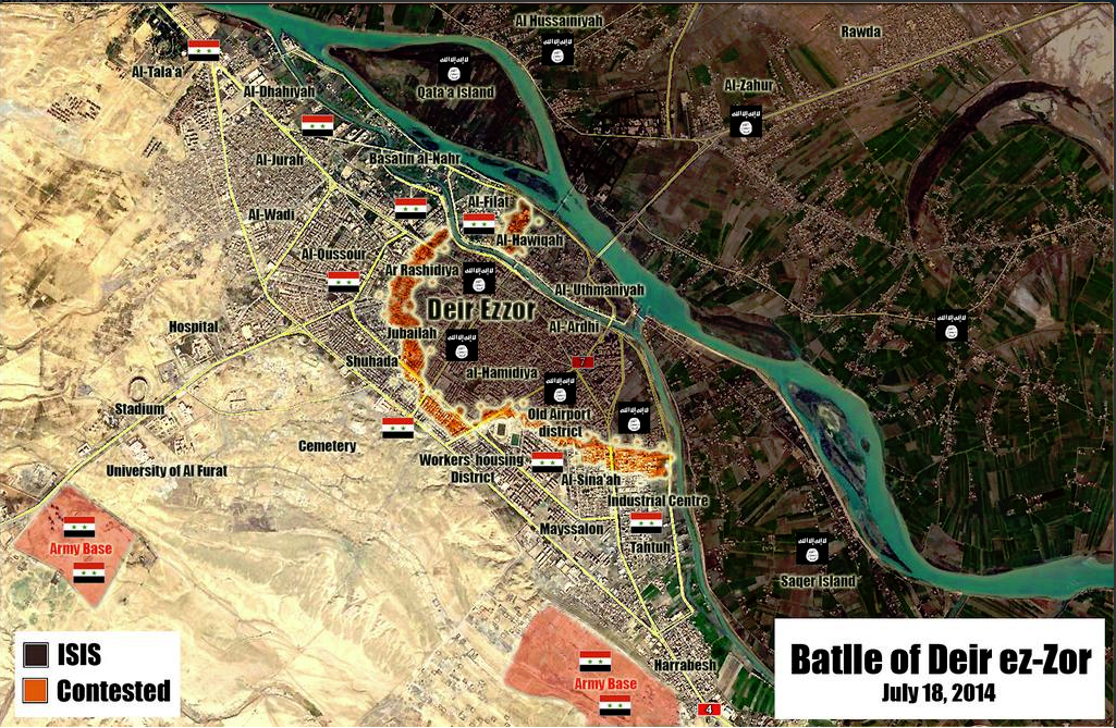
ISIS took controll of the opp held part of Deir El-Zour city according to pro opp source http://www.aljazeera.net/news/arabic/2014/7/14/%D8%AA%D9%86%D8%B8%D9%8A%D9%85-%D8%A7%D9%84%D8%AF%D9%88%D9%84%D8%A9-%D9%8A%D8%B3%D9%8A%D8%B7%D8%B1-%D8%B9%D9%84%D9%89-%D8%AF%D9%8A%D8%B1-%D8%A7%D9%84%D8%B2%D9%88%D8%B1-%D9%88%D8%A7%D8%B4%D8%AA%D8%A8%D8%A7%D9%83%D8%A7%D8%AA-%D8%A8%D8%A7%D9%84%D9%82%D9%84%D9%85%D9%88%D9%86 (Ali bachir (talk) 21:09, 14 July 2014 (UTC))
Semi-protected edit request on 14 July 2014
This edit request to Template:Syrian Civil War detailed map has been answered. Set the |answered= or |ans= parameter to no to reactivate your request. |
Two excessive objects:
1)the entry with label=[[Gire Sor]] and link=#Bagdîk (previous have the same link, and the next have resembling label),
2)Lahaya in two positions (red and lime circles for both).
87.117.178.100 (talk) 21:31, 14 July 2014 (UTC)
- Done
Qalamoun area
Would it be possible to include Ersal in Lebanon as opposition (green) held? This article in Al Akhbar discusses the area, and also includes this line: “The Syrian army controls the villages of Nabek, Qara, and Falita but not their outskirts, which allows [militants] to move across the border.” I'm not sure if these towns are all present on the map. http://english.al-akhbar.com/content/ersal-executions-assassinations-and-chaos — Preceding unsigned comment added by 169.231.67.15 (talk) 16:56, 15 July 2014 (UTC)
- This map shows the situation in the cities and villages and the army controls nearly the entire area Qalamoun but rebels are present in the border area. But we can not display on this map the situation in neighboring Lebanon. But if you're wondering more detail situation you can see on this map.here Hanibal911 (talk) 17:59, 15 July 2014 (UTC)
Rahjan in Hama province was in red why some one change it to contested ?
Why some one change Rahjan to red to contested ?
If the only source is the SOHR or another pro insurgent page it must be change to red is against the rules used pro Insurgent sources to showing Insurgents gains.
Links your sources or it must be back to red We have rules and it's for all towns.
BTW some people confused when they read in SOHR facebook page "Clashed in the Vicinity" or "Clashed near" - Clashed in the Vicinity / Near the town is different than combats inside the town. — Preceding unsigned comment added by 190.203.205.104 (talk) 03:57, 16 July 2014 (UTC)
Al Samdaniyah and Tal Krum
According to documents.sy Syrian army takes control over al-Samadaneya al-Sharkeia and Tal Krum towns of al- #Qunaitera countryside. near madinath al bath and jaba https://www.facebook.com/documents.sy/posts/754358694626889 — Preceding unsigned comment added by 5.46.50.190 (talk) 21:28, 16 July 2014 (UTC)
SOHR not neutral source
Dear editors due to the fact that there are editors which said that the data which are published the SOHR are not reliable I decided to explore all the data relating to this source. And in the process of exploring the many data I came to concluded that this source is anti-government and pro opposition source and all its data are largely based on data of opposition activists and rebels and thus its data can not be used to display the achievements of rebels in clashes against the Syrian army. Because it is the same if we used the data from the SANA to display success of army. Here's confirmation that the SOHR is opposition source and this is confirmed by many reliable sources: read this article in Wikipedia, Also Reuters said that the SOHR it is anti-Assad grouphereand here Also Chicago Tribune said that the SOHR it is anti-Assad group.here and it also confirms First Post and ABC NewsJerusalim PostBusiness InsiderFree Malaysia TodayNews Week So that none of the editors should be no doubt that the SOHR can no longer be used to display the progress of the rebels against the Syrian army. Or should we then use SANA Al Manar of Fara News to display the progress of the army. But otherwise, we also can used data from government sources about such as SANA Al Manar of Fara News to display progress of the army. And that would not break the rules, we must use to edit on the map the data of SOHR or SANA only if their data confirmed the reliable sources. Hanibal911 (talk) 15:45, 7 July 2014 (UTC)
- This discussion has been had, and is closed. You can re-read it in the archives of this talk page if you need refreshing - SOHR CAN and WILL be used to validate advances by ALL sides; SANA, Al-Manar, and Fars cannot be used for gov't advances, without confirmation from alternately aligned outlets. This is an established rule for this map. If you do not abide by it, if you revert edits based on SOHR, or try to edit based exclusively on SANA, Al-Manar, or Fars, I will pursue disciplinary measures against you. It is clear what your intention is. Write off the SOHR and 99% of rebel achievements will go unreported on this map - because 99% of non-gov't aligned news outlets cite the SOHR. The SOHR is the only source that reports EVERYONE'S gains and losses, so just drop it. Boredwhytekid (talk) 16:39, 7 July 2014 (UTC)
- You are broke the rules the edit on this map when you put the green circle near the town which, under the control of the army on the basis of data that said that the rebels only shelled a city. And if you check out all my changes you'll see that I always revert the edits that were made on the basis of government sources to reflect the success of the army. So dont need accuse me of vandalism. And about the source SOHR in Wikipedia clearly states that this is the anti government source.here Hanibal911 (talk) 17:07, 7 July 2014 (UTC)
- That source does not only say they shelled a city, it says they are close enough to fire machine guns into it - that's a difference of being miles away, and being meters away. And how many red circles have popped up around rebel-held towns that are not besieged, but only shelled? Kfar Laha, Tal Dahab, Kissin, basically the entire Homs plains area. Look, I don't have a dog in this fight, but I'm not sitting back and watching you eliminate the most reliable source that we have. I'm not here to argue with you, I'm here to recreate the clearest possible picture of the situation on the ground in Syria. You wanna press this topic, go for it, but you won't get anywhere.. Boredwhytekid (talk) 17:17, 7 July 2014 (UTC)
- We noted these cities because they are in the area which surrounded the Syrian army although I also do not quite with these agree. I think that we need to add an icon that will mean that there are clashes near the city and it should be a icon of the neutral color and so our map gain more relevance. Hanibal911 (talk) 17:28, 7 July 2014 (UTC)
- Yea, we really need an icon for outskirts/environs/vicinity clashes. Boredwhytekid (talk) 17:37, 7 July 2014 (UTC)
- How do you feel about the fact that we will mark it is icon
 when clashes near the town. Hanibal911 (talk) 17:46, 7 July 2014 (UTC)
- How do you feel about the fact that we will mark it is icon
- As in, put as a concentric circle around a town when there's fighting on the outskirts? And only make it the color of one of the combatant parties when it is truly under siege? In theory, sounds good. It would take a lot of editing, and probably arguing lol to implement.. Boredwhytekid (talk) 17:56, 7 July 2014 (UTC)
- We need to put this icon when the source said that fighting is near the city or in its immediate vicinity of the city it is will more precise. Hanibal911 (talk) 18:03, 7 July 2014 (UTC)
- I'm in. Let's put it to a decision. Boredwhytekid (talk) 18:07, 7 July 2014 (UTC)
- But we must be sure that it is really clashes near the city and not only hit and run. Otherwise, we can distort the map. Hanibal911 (talk) 18:12, 7 July 2014 (UTC)
- See, there's where we're going to run into trouble - everyone is going to have a different opinion on what constitutes "clashes" and we'll never all agree. Even hit and run is technically guerilla warfare - if it happens once, ok yea no reason to put the icon - but if it's hit and run attacks for weeks running, like in Qalamoun, what then? Some say circle, some say no.. Boredwhytekid (talk) 18:23, 7 July 2014 (UTC)
Many SOHR reports are true but not all because this is a pro insurgent source is the equivalent to use Syrian Perspective, used only this SOHR to showing insurgents gains (All factions) on map against the government is against the rules.--Pototo1 (talk) 13:11, 17 July 2014 (UTC)
Tasil and Adwan
is it still possible that these villages are still contested,although the opposition seized sheikh saad and the base near it.Alhanuty (talk) 15:44, 17 July 2014 (UTC)
- In response to recent events perhaps we need to searching more information about the situation in this area and try to clarify the situation with these cities. Hanibal911 (talk) 16:17, 17 July 2014 (UTC)
desyracuse It's not a source use it could be against the rules-
Everyone can do a map like that and publish it on twitter any mortal with brain working at 10% can do it http://umap.openstreetmap.fr/fr/map/desyracuse-syria-civil-war-7-july-2014_12153#9/35.3935/37.3178 don't clone that map here -
For change the color for specific town (or add news towns) you need a specific sources from specific town please don't ruin all the map again.
If the pro government source, anti government and "Neutrals" like CNN / BBC, Reuther etc coincided two or all the change is made. --Pototo1 (talk) 22:46, 17 July 2014 (UTC)
New Deir Ez Zor Map
The most recent is pro government but credibility is good http://i.gyazo.com/c1a9a9004995f0ee25ec9a47cc8a9418.png — Preceding unsigned comment added by Pototo1 (talk • contribs) 20:41, 18 July 2014 (UTC)
deir el zor province
according to sohr IS took control over Deir Ezzor Province completely except the regime- held areas . No rebels or locals inside deir el zor province — Preceding unsigned comment added by 5.46.85.148 (talk) 17:30, 18 July 2014 (UTC)
source: https://www.facebook.com/syriahroe/posts/556874567754219 — Preceding unsigned comment added by 5.46.85.148 (talk) 17:35, 18 July 2014 (UTC)
I will change from blue to black because the source is newer and more neutral (the Institute has shown pro-opp tendencies in the past). Besides, reports do say that generally in all of the ISIS territories ISIS leaves local tribes to administer themselves while their troops go to the frontlines (same goes for Iraq). EkoGraf (talk) 18:16, 18 July 2014 (UTC)
I disagree on changing some towns from red to black based on SOHR info in DierErZoor as Ayyash. In fact the following day, this citu was confirmed [6] to be under government control. Paolowalter (talk) 10:13, 19 July 2014 (UTC)
Idlib Provience change
These villages are under the control of SAA :Al-Basheeriyya, Miland, Judaydat Al-Jisr, Duwwayr Al-Akraad http://www.syrianperspective.com/2014/07/syrian-army-deep-in-mork-saa-routs-rats-in-idlib-and-aleppo-50-dead-terrorists-in-aleppo.htmlMZarif (talk) 17:14, 19 July 2014 (UTC)
This source is strongly biased pro-government and therefore it is not reliable. We must have additional neutral or pro-opposition sources before updating the map. Paolowalter (talk) 21:23, 19 July 2014 (UTC)
Tishrin Dam contested
This edit request to Template:Syrian Civil War detailed map has been answered. Set the |answered= or |ans= parameter to no to reactivate your request. |
Tishrin Dam contested ISIS-FSA/IF per pro-gov't http://www.syrianperspective.com/2014/07/al-raqqa-province-updated-map.html Would someone please make this change before it becomes outdated? Boredwhytekid (talk) 12:23, 9 July 2014 (UTC)
- But as we can noted if dam contested. And what should be the icon. We can mark it of this icon or simply mark the different color.
 or
or  Hanibal911 (talk) 13:16, 9 July 2014 (UTC)
My vote is for ![]() , but I leave that to you. Boredwhytekid (talk) 13:36, 9 July 2014 (UTC)
, but I leave that to you. Boredwhytekid (talk) 13:36, 9 July 2014 (UTC)
 Not done: it's not clear what changes you want to be made. Please mention the specific changes in a "change X to Y" format. —cyberpower ChatOnline 08:24, 20 July 2014 (UTC)
Gire sor, Kobane
This edit request to Template:Syrian Civil War detailed map has been answered. Set the |answered= or |ans= parameter to no to reactivate your request. |
Gire sor is on the map 2x, right next to itself.
per wikimapia, this is the location http://wikimapia.org/#lang=en&lat=36.701165&lon=38.799162&z=16&m=b Boredwhytekid (talk) 17:34, 9 July 2014 (UTC)
- Not done: it's not clear what changes you want to be made. Please mention the specific changes in a "change X to Y" format. I'm not seeing it. —cyberpower ChatOnline 08:34, 20 July 2014 (UTC)
Alirhejan
This edit request to Template:Syrian Civil War detailed map has been answered. Set the |answered= or |ans= parameter to no to reactivate your request. |
Allegedly this village, or HQ has been captured by Al Nusre fighters this morning. video pic tw pic
109.175.40.147 (talk) 15:29, 11 July 2014 (UTC)
- Not one of your sources can not be used since they are not reliable. And we can not use pro rebel sources to show success of rebels. Hanibal911 (talk) 15:37, 11 July 2014 (UTC)
Video posted by Al Jazeera and a picture showing one of the captured tanks — Preceding unsigned comment added by DuckZz (talk • contribs) 18:04, 13 July 2014 (UTC)
- In your video not said that the village of captured! And here Al Jazeera said that the rebels have captured only part of the village.Al Jazeera Also SOHR said that: Jabhat al-Nusra have taken over wide parts of the western side of al-Rahjan village, in the eastern countryside.SOHR Hanibal911 (talk) 19:29, 13 July 2014 (UTC)
- Not done: please provide reliable sources that support the change you want to be made. —cyberpower ChatOnline 08:36, 20 July 2014 (UTC)
Semi-protected edit request on 17 July 2014
This edit request to Template:Syrian Civil War detailed map has been answered. Set the |answered= or |ans= parameter to no to reactivate your request. |
in 7/11/2014 YPG withdraw from Kandal village west of Tall Abyad in Raqa Province and it is under IS control. Koroqu village west of Ayn Al-Arab(Kobani) is contested by IS and YPG. IS send a Suicide Motorcycle to a YPG checkpoint in Koroqu. The Suicide attack resulted in the death of IS attacker with no casualties reported by YPG. Sarmedwhivan2004 (talk) 03:18, 17 July 2014 (UTC)
- Please leave a space line before and after headings (== ... ==), otherwise it risks being merged with the previous section (as happened this time).
- Also please add a comment to your edit request instead of duplicating your edit request with the added comment. André437 (talk) 05:12, 18 July 2014 (UTC)
- Not done: please provide reliable sources that support the change you want to be made. —cyberpower ChatOnline 18:30, 21 July 2014 (UTC)
Semi-protected edit request on 16 July 2014
This edit request to Template:Syrian Civil War detailed map has been answered. Set the |answered= or |ans= parameter to no to reactivate your request. |
ISIS have taken controll of the Opp held part of Deir El-Zour City according to several pro opp sources, it should be changed from green to black.
http://arabic.cnn.com/middleeast/2014/07/14/isis-syria-dair-alzour?hpt=continous http://www.aljazeera.net/news/arabic/2014/7/14/تنظيم-الدولة-يسيطر-على-دير-الزور-واشتباكات-بالقلمون http://www.alaraby.co.uk/politics/632f802b-1e17-4e6f-8805-cb6bed71bf61
85.195.139.195 (talk) 15:04, 16 July 2014 (UTC)
 Question: Could you be a little clearer. I'm not able to find that point on the map, if I'm reading it correctly. If you understand Wiki markup pretty well can you provide an X to Y answer. If not, can you provide the coordinates. I may be able to make better use of it. —cyberpower ChatOnline 18:45, 21 July 2014 (UTC)
The Syrian Desert
Hello guys, I just want to suggest a way of showing or illustrating the presence of armed forces other than the SAA in the Syrian Desert. The recent attack on the Sha'er gas field proves my point. Even if this area falls between regions controlled by government forces this doesn't prevent armed elements from traveling through it. The region I'm referring to spans from Eastern Hama to Southwestern Aleppo to Northern Homs to Southern Raqqa. No party can fully control this desert. So I suggest finding a way of showing that the desert is "dominated" by the Syrian Government with a certain armed insurgency present. The same goes for the Qalamoun Mountains as well. ChrissCh94 (talk) 22:00, 20 July 2014 (UTC) ChrissCh94
- Good luck barking up that tree buddy. Really, in all seriousness, good luck. Boredwhytekid (talk) 18:48, 21 July 2014 (UTC)
Brigade 61, Hanajak and Sheik Al Sa'ad
This edit request to Template:Syrian Civil War detailed map has been answered. Set the |answered= or |ans= parameter to no to reactivate your request. |
I can't find the Sheik Sa'ad checkpoint on the map, maybe you have put some different name or ? Tour trought brigade 61 and Hanajak 2 tweets, still waiting for an neutral source, and actually I was only interested for the first checkp. DuckZz (talk) 22:14, 16 July 2014 (UTC)
- Not done: please provide reliable sources that support the change you want to be made. —cyberpower ChatOnline 18:49, 21 July 2014 (UTC)
Ayn Al Arab
This edit request to Template:Syrian Civil War detailed map has been answered. Set the |answered= or |ans= parameter to no to reactivate your request. |
in 7/11/2014 YPG withdraw from Kandal village west of Tall Abyad in Raqa Provimce and it is under IS control. Koroqu village west of Ayn Al-Arab(Kobani) is contested by IS and YPG. IS send a Suicide Motorcycle to an YPG checkpoint in Koroqu. The Suicide attack resulted in the death of IS attacker with no casualties reported by YPG.
reference http://www.alaan.tv/news/world-news/109044/battles-in-the-countryside-of-raqqa-and-ain-arab-between-isis-and-kurds-syria Sarmedwhivan2004 (talk) 03:19, 17 July 2014 (UTC)
- Not done: it's not clear what changes you want to be made. Please mention the specific changes in a "change X to Y" format. —cyberpower ChatOnline 18:49, 21 July 2014 (UTC)
Quruqo Should be changed from "yellow" to "yellow and black"(contested)
can any one checks out some sources of clashes in Jibnah east of Jarablus. situation is not clear there.
Semi-protected edit request on 18 July 2014
This edit request to Template:Syrian Civil War detailed map has been answered. Set the |answered= or |ans= parameter to no to reactivate your request. |
Two black circles for Khasham, need to remove the excess. 87.117.178.100 (talk) 20:38, 18 July 2014 (UTC)
 Done I removed the larger one. If you wanted me to remove the smaller one, let me know. —cyberpower ChatOnline 18:52, 21 July 2014 (UTC)
Sibi Quran and Ahmadiyah under IS control? -Eastern Kobane front-
The SOHR article linked [1] for the edit only mentions an IS vehicle being targeted between the two villages, it doesn't really imply that both of them (if any) are under IS control.
Is there any other source on the matter be it pro-IS or pro-kurdish?
186.119.179.239 (talk) 02:07, 22 July 2014 (UTC)
Is against the rules add news towns on map without sources stop to that.
Is against the rules add news towns using only maps about held territories, any person can made a map and post that on twitter.
You need to link a specifics sources for add a specific town to map--Pototo1 (talk) 04:44, 22 July 2014 (UTC)
"Eastern Palestine" beneath Jaz'ah?
"Eastern Palestine" beneath Jaz'ah? Boredwhytekid (talk) 13:26, 22 July 2014 (UTC)
Cite error: There are <ref group=Rara Tall Abyad> tags on this page, but the references will not show without a {{reflist|group=Rara Tall Abyad}} template (see the help page).