
Talk:Control of cities during the Syrian civil war/Archive 22
| This is an archive of past discussions. Do not edit the contents of this page. If you wish to start a new discussion or revive an old one, please do so on the current talk page. |
| Archive 15 | ← | Archive 20 | Archive 21 | Archive 22 | Archive 23 | Archive 24 | Archive 25 |
Atshan in Hama
This edit request to Template:Syrian Civil War detailed map has been answered. Set the |answered= or |ans= parameter to no to reactivate your request. |
Why don't you add Atshan city in Hama. The city should be added to the map to show a proof that rebels control the area between Mork and Atshan, or it will show that the SAA is already in south Idlib.
location: http://wikimapia.org/#lang=en&lat=35.406821&lon=36.822567&z=14&m=b
the city is under rebel held and it was attacked by chemical gas in april 2014, 3 months ago. I know the sources that shows the city under rebel held are not enough, but would help.
SyianCoalition
Muslim Brotherhood SN4HR 178.77.148.235 (talk) 18:36, 26 July 2014 (UTC)
Is against the rules used anti goverment sources to showing insurgents advances (All insurgents groups) — Preceding unsigned comment added by LogFTW (talk • contribs) 18:44, 26 July 2014 (UTC)
 Not done: Topic banned editor, closing this down --Mdann52talk to me! 08:20, 7 August 2014 (UTC)
Need evidences Al-Khama'il in Hasakah is controlled by ISIS
The only "Source" for change Al-Khama'il (The small town near the regiment 121) from red to black was a claim from a liveleak user http://www.liveleak.com/view?i=fb7_1406496921
As I know the ISIS only claim captured severals days the artillery Regimen 121 never the Al-Khama'il town
If nobody link at least a single source it's controlled by the ISIS I will be change that to red --Pototo1 (talk) 05:24, 6 August 2014 (UTC)
I propose that Hasaka map is removed and the city is turned into red-yellow-red like Qamishli. YPG and government are not in conflict and the boundary are of little meaning. The city map has never been updated once. In this way we can describe more accurately the situation in the surroundings. Paolowalter (talk) 22:05, 6 August 2014 (UTC)
One pro-Kurdish source claimed Al-Khama'il was IS controlled at the end of July and not aware of any reliable sources saying it has been recaptured. http://aranews.org/2014/07/%D8%A7%D9%84%D8%AD%D8%B3%D9%83%D8%A9-%D9%87%D8%AF%D9%88%D8%A1-%D9%81%D9%8A-%D8%A7%D9%84%D9%85%D8%AF%D9%8A%D9%86%D8%A9-%D9%88%D9%86%D8%B2%D9%88%D8%AD-%D9%81%D9%8A-%D8%A7%D9%84%D8%B1%D9%8A%D9%81/ Dulldul (talk) 09:13, 7 August 2014 (UTC)
News small gains for Army in Aleppo zone
There is a SAMA TV Channel report https://www.youtube.com/watch?v=L4BG3zCoU3w Using google translator = Aleppo, the army controls the hill Paso area and Alseriaatal hill in Al-Zaid Khan Toman
Syrians News Channel in same area https://www.youtube.com/watch?v=XdlXGjhFs34 Using google translator = Aleppo | | Army controls several areas in Khan Toman
This anti government source http://syria direct . org/rss/1481-syria-direct-news-update-8-6-2014 said the army take the control in Khan Touma in southern Aleppo
Aleppo is different than Ghouta in Damascus or Hama in Aleppo the Army usually doing more progress --Pototo1 (talk) 17:14, 6 August 2014 (UTC)
Most of the resources and men of the SAA its being used in the Aleppo Front, it seems that the Regime can only attack on to fronts actually(Isis on the East and FSA on Aleppo), Another issue should we indicate the Town of Arsal in this template or better said its usefull to use this type of template for all lebanon? like was done on Iraq??200.48.214.19 (talk) 14:39, 7 August 2014 (UTC)
Stop to vandalize the Hasakah city map putting all city in Kurdish Insurgents Hands
Change every the time the status from major city again and again is concerted trolling action the users who are doing these practice on Hasakah city are User:Roboskiye and User:Alhanuty
This no happens one two or three times, severals times the major city map have been change to full Yellow.
The Power Electrical Station is under Army control According to Official Syrian TV at the day July 27 2014
The Kurdish insurgents controlled parts of Hasakah city?
Yes since a lot time ago this is a well know for all.
But Extensive parts from the City are under government control it including the Hasakah Electrical Power Station, the Juvenile Prison and the 546th artillery brigade.
The User:Roboskiye put on Kurdish insurgent Hands the 546th artillery brigade the Hasakah electrical power Station and the Entire Hasakah city without any solid evidence for doing these changes.
For Change the color a ENTIRE MAJOR CITY you need to have VERY Extensive visual evidences and a VERY solid sources.. The Government troops have extensive presence in all bigger City expect in Raqqah since more than a year ago.
TV Report from Hasakah city Government Held sector from 4 August of 2014 TV Report from Hasakah city Government Held sector from 5 August of 2014 --Pototo1 (talk) 00:31, 6 August 2014 (UTC)
YPG has shown visual evidence of being in control of Azizia neighborhood and the Electrical Substation more recently than the Government (4 Aug vs 27 July), NOT the city center nor the Nashwa neighborhood both of which have been proven to be under Govt control by more neutral sources.
Report about being in control of Azizia, with photos: http://www.hawarnews.com/index.php/component/content/article/43-2013-02-24-21-16-12/17321-2014-08-04-06-33-10
Report about being in control of Prison and the Electrical Substation, with 8 photos: http://www.hawarnews.com/index.php/component/content/article/43-2013-02-24-21-16-12/17360-2014-08-04-12-02-18
They ARE kurdish sources but at the very least the one about the electrical station and the prison is easily verifiable, just by checking the photos and comparing them to the July 27th SAA report or using wikimapia which I posted in the previous Hasakah discussion.
Azizia might be harder, can any arab speaker identify the words shown in the photos?179.32.115.109 (talk) 01:44, 6 August 2014 (UTC)
Also, why are ALL the reports about YPG and SAA working together against IS being ignored? Many sources, kurdish (Adar Press, Aranews), lebanese (al-akhbar) and govt (Syr Perspective) have reported so in repeated ocassions, should just put Hasakah three ringed as Qamishli, leave Guerran as the small contested dot and mark the subelectrical station as jointly controlled, as per Adar Press 27 July report which claimed the area was controlled by both of them and which is still referenced at the bottom of this discussion page.
179.32.115.109 (talk) 01:54, 6 August 2014 (UTC)
This Syria Government TV is from August 4 https://www.youtube.com/watch?v=Q7qJEOkb inside the Hasakah Electric Plant.
The Government controlled extensive parts from the city this is a fact and after the counter attack against the ISIS the government made news gains according to Opposition Sources https://www.facebook.com/syriahroe/posts/562706100504399 . — Preceding unsigned comment added by 201.242.81.78 (talk) 02:55, 6 August 2014 (UTC)
Hawarnews report is from the same date.
SOHR, the same Opposition Source (SOHR has posted anti-PYD statements in more than one ocassion so they are def. not pro-kurd) posted that YPG entered Guerran neighborhood and a gunfight ensued:
https://www.facebook.com/syriahroe/posts/564819333626409
So, how did YPG enter Guerran without being in the city center or without being allied with SAA forces? If the govt is friendly enough to YPG to let a convoy cross an area they control without any report of clashes then either that zone is not controlled by them or they have a ceasefire/alliance strong enough to justify putting the city like Qamishlo, the latter of which is verified by several neutral enough sources from all sides.
And yet another report from less than 24 hours ago:
http://aranews.net/2014/08/sunni-insurgents-attack-ypg-pro-assad-forces-syrias-hasakah/
179.32.115.109 (talk) 03:59, 6 August 2014 (UTC)
the kurdish source states that the government controls the governorate uilding in the center of hasakah city,so only the center is regime-held,the rest is YPG.Alhanuty (talk) 19:46, 6 August 2014 (UTC)
- @user canibal,: The pro-regime forces guard two buildings in entire Hasaka city, which is totally negligible. This is even mentioned in your source: On the other hand, the pro-regime military forces, who are stationed at al-Hasakah governorate building. Roboskiye (talk) 20:58, 6 August 2014 (UTC)
Just report Roboskiye for vandalism here is a TV report from Hasakah August 6 2014 in government held areas the Goverment controlled huge extensive areas in Hasakah city — Preceding unsigned comment added by 186.94.210.127 (talk) 22:16, 7 August 2014 (UTC)
Can the yellow circle around be applied to the Power Station too? Would be more representative of the current situation as both forces have been confirmed to be present in the place.
186.112.221.39 (talk) 03:34, 8 August 2014 (UTC)
Hasakah city map should be updated / Fixed
This map https://commons.wikimedia.org/wiki/File:Battle_of_Hasakah.svg should be fixed because is just a clone from @archicivilian and Cedric Labrousse both anti Syrian government sources, in my personal opinion Cedric Labrousse still aceptable as source but @archicivilian is just very bad.
The 5 towns taken by the army according by other anti Government source (SOHR) are most probability in areas who are now in black on this map-
PS stop to used anti government sources all the time for made all changes on map. --Pototo1 (talk) 17:52, 3 August 2014 (UTC)
I have already made similar comments. The map is not updated and is, in a sense obsolete, because it pitches SAA and YPG as enemy (even if they never fought each other). Now they are collaborating, so apparently there is not much difference between yellow and red nowdays. Some part of the black should turn red and I wonder on which source the rest of the black area is based. Paolowalter (talk) 19:01, 3 August 2014 (UTC)
The Kurdish insurgents severals times attack the Syrian Army positions but minor clashed no major scale armed actions.
Since February 2014 to June 2014 the ISIS, Kurdish insurgents and government forces was in de facto cease fire, the ISIS broke that attacking the Army position in Gas Homs capm, Division 17, Regimen 121 and several zones in Hasakah.
The ISIS attacks was successful in division 17, and at the moment partiality in Regimen 121 but were repelled in Homs gas camp and in north East of Hasakah seems they were push back and latter they lost more grounds there since their attacks against the government star.
There could be a updated = http://sia1.subirimagenes.net/img/2014/08/04/140804043125826018.jpg the red lines could be the new Government held territories after the Counter attack according to anti government sources, the South held territory is based on this pro government map from July 27 before the counter Army attack https://twitter.com/PetoLucem/status/492621701193420801/photo/1 — Preceding unsigned comment added by Pototo1 (talk • contribs) 02:36, 4 August 2014 (UTC)
Not so sure about the changes, in this article YPG from pro-kurdish aranews they claim to be in control of the Power Station and the Juvenile Prision south of the city, for the former of which they actually have solid visual proof of:
Photo in the Power Station:
https://pbs.twimg.com/media/BuAQcrbCIAAtKVa.jpg
Position on wikimapia, the building to the right is the same one in the background:
http://wikimapia.org/#lang=en&lat=36.452356&lon=40.773187&z=18&m=b
Another photo in the Power Station:
https://pbs.twimg.com/media/BtxiQUcIEAAOfRK.jpg
What source was used to put the electrical station again under SAA control? Was it a more or less neutral one with visual confirmation?
Also, about reducing YPG control east of the city, here is YPG member Polat Jan taking a photo near of the top of Kawkab, which actually is in accordance with current distribution of control:
https://pbs.twimg.com/media/BuAQcLrCYAE_RGI.jpg:large
On wikimapia:
http://wikimapia.org/#lang=en&lat=36.536019&lon=40.857441&z=18&m=b
190.67.230.216 (talk) 04:20, 4 August 2014 (UTC)
- Agree with user IP 190.67.230.216. The city of Hasaka is controlled by YPG and there is no regime presence inside the city. http://www.alquds.co.uk/?p=201746 Roboskiye (talk) 08:20, 4 August 2014 (UTC)
- Not Agree because YPG and Syrian Army is jointly controlled by the city.ARA NEWS And your sources are not reliable. Because photos from Kurdish pages in Twitter is not a good proof. Hanibal911 (talk) 08:44, 4 August 2014 (UTC)
- Agree with user IP 190.67.230.216. The city of Hasaka is controlled by YPG and there is no regime presence inside the city. http://www.alquds.co.uk/?p=201746 Roboskiye (talk) 08:20, 4 August 2014 (UTC)
- There is no cooperation between YPG and SAA. This joint thing is only an accusation of opposition to denigrate YPG. YPG has many times clearly refused such accusations. Roboskiye (talk) 08:51, 4 August 2014 (UTC)
Today pro-Kurdish news agency reports YPG seized Aziziya neighbothood of al-Hasakah city from ISIS (link). Remaining ISIS elements fled towards southern neighborhoods. Aziziya was controlled by Syrian Army for the last 3 years. --TheoDor12 (talk) 13:10, 4 August 2014 (UTC)::
- Furthermore it reports YPG captured the Kawkab hill from SAA, al-Ahdas prison and power plant from ISIS (link) --TheoDor12 (talk) 13:32, 4 August 2014 (UTC)
- We do not use pro Kurdish sources to display success YPG. Hanibal911 (talk) 13:37, 4 August 2014 (UTC)
To the contrary, Kurdish sources are fine to use, just in case we would have two contradicting news, the non-Kurdish would outweigh Kurdish ones, yes. So do you have any statements contradicting these news? PS: ARANEWS is also pro-Kurdish. --TheoDor12 (talk) 13:49, 4 August 2014 (UTC)
In any case, do we have any source at all for putting the Power Station under SAA control? Both sides have claimed to recapture it, but (as far as I know) only YPG has visual proof even though it's from twitter.
186.112.195.157 (talk) 15:58, 4 August 2014 (UTC)
The source the Army controlled Juvenile Prison and electrical station are Cedric Labrousse and @archicivilian both anti Syrian government sources Labrousse supported the Kurdish Insurgents too.
On this Syrian TV report (It's not "you tube" is the official News TV Report) showing very extensive visual evidence the Army controlled the Juvenile Prison and electrical power station now the point is added the News Army advances according to Anti government SOHR the rule is if a Anti government source showing Army gains we need to used that. --Pototo1 (talk) 16:44, 4 August 2014 (UTC)
Thanks Pototo1, though it seems really weird, ANHA (pro-kurd) just showed pretty recent solid evidence of YPG presence in that area:
So, we go with al-akhbar and adar press reports which claim they are operating together in the area? I don't think there would be other reasons for both SAA and YPG posting material in control of the exact same locations without any reports of clashes between the two parties. — Preceding unsigned comment added by 186.112.195.157 (talk) 17:02, 4 August 2014 (UTC)
- Yet, another neutral source confirming Hasaka being under YPG control: http://www.alaraby.co.uk/politics/a3d67d29-6611-4162-b308-b40b5254ff25 Roboskiye (talk) 22:24, 5 August 2014 (UTC)
- Regime forces still presents around the city Hasaka and also in some neighborhoods for example regime troopsand the Kurds together guarded Ghuwayran neighbourhood.ARA News Hanibal911 (talk) 18:59, 8 August 2014 (UTC)
- We need update this map in according situation on the ground because now clashes started as the YPG and pro-regime forces repeatedly tried to enter Geweran neighbourhood through Beiruti bridge but blocked by IS militants, who are in control over the neighbourhood. But also pro opposition Kurdish source said that any claims that regime has handed over areas to the YPG is untrue YPG cooperation with the regime troops forces to protect Hasakah.ARA News Hanibal911 (talk) 13:05, 9 August 2014 (UTC)
- Regime forces still presents around the city Hasaka and also in some neighborhoods for example regime troopsand the Kurds together guarded Ghuwayran neighbourhood.ARA News Hanibal911 (talk) 18:59, 8 August 2014 (UTC)
- Yet, another neutral source confirming Hasaka being under YPG control: http://www.alaraby.co.uk/politics/a3d67d29-6611-4162-b308-b40b5254ff25 Roboskiye (talk) 22:24, 5 August 2014 (UTC)
Brigade 93, Raqqa
SOHR claiming ISIS and SAA are fighting inside of Brigade 93: https://www.facebook.com/syriahroe/posts/565560680218941 / https://www.facebook.com/syriahroe/posts/565678366873839. Quotes SOHR as saying the entire base is in IS hands: http://www.aawsat.net/2014/08/article55335153. Quotes SOHR as saying the base is partially in ISIS hands: http://www.dailystar.com.lb/News/Middle-East/2014/Aug-07/266346-jihadists-storm-syrian-army-base-in-raqqa.ashx#axzz39hvuDtnr. Contested icon? Boredwhytekid (talk) 12:17, 7 August 2014 (UTC)
Pro-opposition sources saying IS captured the base. tweet, tweet2, RMC — Preceding unsigned comment added by 109.175.91.244 (talk) 12:48, 7 August 2014 (UTC)
- When there are clashes to the military facility, we dont noted it the other icons. Also army base 93 is not captured by IS.SOHR Hanibal911 (talk) 13:24, 7 August 2014 (UTC)
The ISIS captured Ayn Issa and the external perimeter from the brigade 93 and continue heave clashed inside based on the visual evidences seems the ISIS got substantial advances on Brigade 93.
Dozens of soldiers beheading but no captured at all at the moment --Pototo1 (talk) 13:40, 7 August 2014 (UTC)
- Jihadists from the Islamic State group have seized parts of a military base in Syria's Raqqa province.NOW NewsThe Daily StarSahara samayTrend NewsAl Jazeera Also according to data from many sources we know that IS captured only part of army base brigade 93 but clashes continues. Hanibal911 (talk) 15:26, 7 August 2014 (UTC)
reliable sources confirm the YPG controls most of the city except,important government buildings in the center of hasakah.Alhanuty (talk) 20:19, 8 August 2014 (UTC) ^^ agreed - clashes continue - leave SAA controlled with black circle around it until situation is clarified. Boredwhytekid (talk) 15:38, 7 August 2014 (UTC) ISIS full control: http://www.aawsat.net/2014/08/article55335153Boredwhytekid (talk) 18:37, 7 August 2014 (UTC)
- It is of the morning article but many other sources confirmed that the fighting still going.Al JazeeraThe Daily StarReuters Hanibal911 (talk) 18:54, 7 August 2014 (UTC)
by the way ,why is hasakah full yellow again? — Preceding unsigned comment added by 195.155.234.195 (talk) 20:19, 7 August 2014 (UTC)
Hasakah is change to Full Yellow because a user called Roboskiye is a dumb Obstinate troll who did and continue doing a lot vandalism on this map — Preceding unsigned comment added by 186.94.210.127 (talk) 22:09, 7 August 2014 (UTC)
After the vandalism of Roboskiye I pursued my suggestion of turning the city in a non-combat zone managed jointly by government and YPG, as it is. As an additional confirmation, see the pro-opp site www.syriadirect. org/rss/1481-syria-direct-news-update-8-6-2014 (at the end) saying: "IS began its attempt to wrest the city from joint regime-Kurdish (PYD) control ... ".Paolowalter (talk) 06:31, 8 August 2014 (UTC)
- Mr actual vandalist! Your three nested circles imply that there is a fifty/fifty control over the city. But the truth, provided in aforementioned references clearly indicates that YPG has a far more control over different regions of the city and that the tiny pro-regime survivors are concentrated just in one or two buildings inside the city. So my solution i.e a small red dot for state buildings is the only choice. Roboskiye (talk) 10:55, 8 August 2014 (UTC)
Roboskiye if you take a look at the map you can see clearly that the city is split 50-50 but with the latest agreement between the government and the Kurds they have merged there forces into one force to counter the ISIS threat so the city is in mutual control with patrols mixed with both YPG and NDF/SAA forces.They patrol the whole city and cooperation between them is high with joint operations against ISIS.Source:[1][2].Daki122 (talk) 13:59, 9 August 2014 (UTC)
Ishtabraq cp
This edit request to Module:Syrian Civil War detailed map has been answered. Set the |answered= or |ans= parameter to no to reactivate your request. |
According to Nusra spokesmen this small checkpoint was destroyed by a martydom operation, also SOHR statement. Hard to say but should the checkpoint be removed ? 109.175.45.12 (talk) 16:22, 9 August 2014 (UTC)
- First source is not reliable and SOHR only said that islamic bomber blew himself up at a checkpoint but it does not say that this checkpoint completely destroyed. Need more data. Hanibal911 (talk) 16:41, 9 August 2014 (UTC)
- It's called suicide terrorist attack.. --Pototo1 (talk) 17:45, 9 August 2014 (UTC)
Deir-el-Zoor tribes
From SAA facebook page https://www.facebook.com/syrianmilitary/photos/a.349106328504089.83004.349059891842066/702191739862211/?type=1 they states that the local tribes are supported by SAA and are supportive of the government. If the info is converted, the blue coul become red. Paolowalter (talk) 22:00, 8 August 2014 (UTC)
Not really. Same tribes and rebels were part of the SMC and ADF before ISIS advance. I would like to put them to green but it's just my opinion. How can you put rebels from these towns to red if the same people waved FSA flags 3 years ago. — Preceding unsigned comment added by 109.175.45.12 (talk) 14:04, 9 August 2014 (UTC)
You need some other sources to verify this. According to SAA command these tribes in the past were part of the opposition but after opposition fell in the area and after seeing brutality of IS they have now begun working with the gov. SAA claims to have air dropped them weapons & ammo. Need other sources to back this all up. — Preceding unsigned comment added by 169.231.65.28 (talk) 14:53, 9 August 2014 (UTC)
Syrian Army offers a "moral support" for the rebels fighting ISIS along the Euphrat. Suddenly every SAA supporter based on that concluded that rebels recived weapons, food, artillery, air and ground support ... lol that's all I can say. — Preceding unsigned comment added by DuckZz (talk • contribs) 16:12, 9 August 2014 (UTC)
The official sources said were "Residents" http://www.sana.sy/en/?p=9444
These tribes are not part from the NDF / Army they could be now like the Kurdish insurgents before they was west backed insurgents supported and in the practice part from FSA doing self defense role but now when FSA / Al Qaeda / Islamic Front are gone in Deir ez Zor area they are a autonomous armed group only doing self defense role, some pro government facebook pages said the Syrian State forces are aiding them with Air Strikes and aerial drops.
The FSA no exist now and never exist they are only many irregular armed gangs grouped in this name but never a Army with organized central leadership. --Pototo1 (talk) 19:17, 9 August 2014 (UTC)
The ISIS not advances inside Hasakah city
The news maps on Hasakah city can be incorrect it showing extencive parts from Hasakah city in ISIS hand this is not true so the ISIS not advances inside Hasakah urban city areas, Hasakah it's not like Aleppo in Hasakah the Insurgents are not in urban structure only the Kurdish insurgents in South but the whole north of the Entire city is controlled by the Army with no ISIS presence.
In Hasakah city the ISIS attack the Juvenile prison, Power Electric Plant and the Baath Party building.. In these 3 places they were repelled.
The Whole city is stable without major problems.
Here is the external perimeter from North of Hasakah city day 8 August 2014 https://www.youtube.com/watch?v=KzQXYBdH3bE
Hasakah city Army held sector august 3 2014 https://www.youtube.com/watch?v=5p6wPTpfyP0
Here is the TV Report from the ISIS attack on Hasakah city (Repelled) https://www.youtube.com/watch?v=_S5nwmJf2yI
Here is the attack on Baath party Hasakah building (Repelled)
https://www.youtube.com/watch?v=gjGn_qJiHlM
Map from July 25 when the Hasakah Electrical power Station was under ISIS control (This was repelled latter) https://twitter.com/PetoLucem/status/492621701193420801/photo/1
The ISIS not controlled part from Hasakah city urban restructure they are away in South east of the city --Pototo1 (talk) 00:16, 10 August 2014 (UTC)
Abo al-Dohor area
according to sohr clashes taking place between regime forces and Islamic battalions in Abo al-Dohor area (not airbase).We should abu al duhur contested. source: https://www.facebook.com/syriahroe/posts/566614470113562 — Preceding unsigned comment added by 176.42.118.246 (talk) 07:32, 9 August 2014 (UTC)
This could be correct because was reported time ago the Army controlled the extensive perimeter from Abu al-Duhur air base it including the east zones of Abu al-Duhur town, On Air base is not a effective siege since February 2014 https://en.wikipedia.org/wiki/Talk:Cities_and_towns_during_the_Syrian_Civil_Abu al-Duhur But some users decided keep that under siege... These users decided latter add too more towns outside Abu al-Duhur air base without sources.... --Pototo1 (talk) 14:19, 9 August 2014 (UTC)
SOHR should be banned as source, and the posters also. They work with al qaeda spies and "activists". The editor is a FSA beheader supporter in UK — Preceding unsigned comment added by Totholio (talk • contribs) 08:57, 10 August 2014 (UTC)
About aleppo map
When kurds lose half of sheikh masqoud and rebels capture military research center and half of hamdaniya contested?.sorry but aleppo map become bs. http://en.wikipedia.org/wiki/Battle_of_Aleppo_(2012%E2%80%93present)#mediaviewer/File:Battle_of_Aleppo_map.svg — Preceding unsigned comment added by 176.42.118.246 (talk) 14:50, 9 August 2014 (UTC)
#mediaviewer/File:Battle_of_Aleppo_map.svg)
- GTFO sohr fanboy.
- The Kurds did not loose half of Sheikh Masqoud. They lost the Ashrafiyeh district, which has been confirmed in numerous posts by SOHR to be government-held. The western QUARTER (not half) of Hamdaniya is contested since rebels made an incursion into it during an offensive back in January-March. As for the research center, I need to check on that. EkoGraf (talk) 15:31, 10 August 2014 (UTC)
al-Shandakhia
The village of al-Shandakhia in Homs province is ISIS-held with fighting in its outskirts [3]. Please find it on the map and add it. EkoGraf (talk) 17:12, 10 August 2014 (UTC)
- I'm trying! Hanibal911 (talk) 17:20, 10 August 2014 (UTC)
- Maybe it is nearby vilage of Shayha (Shuwayhah). Hanibal911 (talk) 19:05, 10 August 2014 (UTC)
This Pro-government site names the same villages but also says "the area around Jeb al-Jarrah", a thats only I could find on this map ... just put this village to contested and its surroundings, I belive we can't do much more. — Preceding unsigned comment added by DuckZz (talk • contribs) 22:02, 10 August 2014 (UTC)
Regiment 121
The regiment needs to be putten back in Army hands as only one source claims that ISIS had control of the regiment and that is SOHR here is another sources that claims ISIS did not take the base [4].Daki122 (talk) 16:44, 10 August 2014 (UTC) ISIS did take the Regiment & made a lot of videos and pics http://www.liveleak.com/view?i=ffc_1407290007. The Government left their Artillery base at Kawkab hill for YPG to encircle ISIS. But ISIS Defied the encirclement and the government are in a backward J position around Shadadi with their only open supply route is to Hasaka where YPG members are providing supplies for the government forces. ISIS are in control of Sabah AL Kher Silos but they have not cut the YPG-Government supply route yet.
- It is not! Because YPG spokesman said that any claims that regime has handed over areas to the YPG is untrue. This information was published in pro opposition source.ARA News and pro opposition source ISW also confirm that Kawkab Artillery Base under army control. Hanibal911 (talk) 19:38, 10 August 2014 (UTC)
i am telling you here Hannibal,ISW is a military institute website,it has nothing to do with pro-opposition or assad. Alhanuty (talk) 00:08, 11 August 2014 (UTC)
The pictures and videos that ISIS posted where from the same day and were filmed by the same group since then many sources claimed that the Army retook the base so those videos are actualy good propaganda but are not a proof that ISIS still holds the base.Daki122 (talk) 19:54, 10 August 2014 (UTC)
West Aleppo
A pro-opp side [5] states that three villages in west Aleppo were taken by SAA but it does not say which ones. That corresponds to what reported in https://twitter.com/ResistanceER/status/496331592735137794. Similar news come from https://www.facebook.com/syriahroe/posts/564364013671941 and www.syriadirect.org/rss/1481-syria-direct-news-update-8-6-2014. We and the Aleppo map should be updated even if the extent of the changes is not clear.Paolowalter (talk) 19:34, 11 August 2014 (UTC)
I think we need to fix this map first.http://commons.wikimedia.org/wiki/File:Battle_of_Aleppo_map.svg — Preceding unsigned comment added by 195.155.201.18 (talk) 20:24, 11 August 2014 (UTC)
beheaders sourced admit the beheaders was cleared got fucked updated the map
moderated beheader source said SAA captured Mleiha
location was encircle now they said the SAA controlled all of that waiting more info anyway. https://www.zamanalwsl.net/en/news/6127.html — Preceding unsigned comment added by 190.203.244.2 (talk) 21:08, 11 August 2014 (UTC)
Maliha still under siege.Army sources say huge reinforcements including republican guards arrived to jobar and maliha to finish the two fronts. https://www.facebook.com/BUTULAAT.ALJESH.ALARABI.ALSOURI2/posts/818055878227316 Still rebels inside maliha.We need to wait. — Preceding unsigned comment added by 92.44.169.122 (talk) 07:16, 12 August 2014 (UTC)
- Official pro-opposition source clearly said that the Syrian regime forces have recaptured northern districts of al-Mleiha east Damascus, a week after breaking the siege on the embattled town by rebels, freeing 700 besieged fighters.Zaman Alwslsource Hanibal911 (talk) 08:49, 12 August 2014 (UTC)
- Source says the northern part of the town was captured, not the whole town. EkoGraf (talk) 13:30, 12 August 2014 (UTC)
Mleiha the north is in Army hands Damascus map should be updated
Map made by the insurgents https://www.zamanalwsl.net/en/uploads/0e472c625c741be433a31de3.jpg Red = Army --Pototo1 (talk) 14:37, 12 August 2014 (UTC)
+We need to fix eastern ghota too.This report from feb 25 2014.source: http://www.dailystar.com.lb/News/Middle-East/2014/Feb-25/248401-un-resolution-brings-little-change.ashx#axzz2sk38sDRI Report say '...in the eastern outskirts of Damascus, near a railway marking the front line between Islamist fighters and Assad’s forces backed by Hezbollah,' railway: http://wikimapia.org/#lang=tr&lat=33.504043&lon=36.554604&z=13&m=w And rebels didnt advance in that area in 2014. And If railway is frontline ,jarba - qasimiyah - qaysa - abbadeh should be under army control. I say same thing 2-3 motnhs ago but nobody fix.Sorry my bad english. — Preceding unsigned comment added by 92.44.169.122 (talk) 15:00, 12 August 2014 (UTC)
- The Syrian troops are working to tighten the siege on the town of Mlaiha in the countryside of the capital Damascus, adding that the government forces intensified their operations in the Mlaiha and its surroundings in tandem with similar operations in the nearby towns of Zabdin and Jisreen, where the troops killed many rebels.Yahoo news Hanibal911 (talk) 15:14, 12 August 2014 (UTC)
Takharim
At least 35 rebels were killed by the Syrian forces in the country's northern province of Idlib, most of those killed in the town of Takharim in Idlib belonged to the Nusra Front.News WalaPolitics BallaIANS LiveWeb India 123 NewsYahoo News Hanibal911 (talk) 15:06, 12 August 2014 (UTC)
Are you joking or what ? Posting 5 sources where every page quotes Syrian SANA news lol... DuckZz (talk)
- First, these data were published in reliable sources. And secondly I'm not saying that we should immediately change this city on contested. And you reproach me that I provide not reliable information, but although yesterday you yourself have published information that the rebels captured two military facilities in the Hama province and provided as sources that confirm your data two rebel amateur video from the YouTube. Hanibal911 (talk) 15:52, 12 August 2014 (UTC)
- Syrian warplanes bombard the town of Kafar Takharim yesterday, reports of more casualties.SOHR Here the data which explained situation with the city Takharim all rebels were killed by air strike! Hanibal911 (talk) 16:17, 12 August 2014 (UTC)
Villages west of Aleppo captured by SAA
A moderate source [6] says the Army captured three villages west of Aleppo after rebel infighting. Doesn't name the villages though, please try to find some info identifying them. Thank you! EkoGraf (talk) 13:30, 12 August 2014 (UTC)
- Also previously pro opposition source said that army recaptured most part the town of Khan Touman. www.syriadirect.org/rss/1481-syria-direct-news-update-8-6-2014 Hanibal911 (talk) 13:43, 12 August 2014 (UTC)
there is the discussion open about Khan Touman https://en.wikipedia.org/wiki/Talk:Cities_and_towns_during_the_Syrian_Civil_War#News_small_gains_for_Army_in_Aleppo_zone — Preceding unsigned comment added by Pototo1 (talk • contribs) 14:52, 12 August 2014 (UTC)
Same discussion ongoing on the page of Aleppo https://en.wikipedia.org/wiki/File_talk:Rif_Aleppo2.svg#South_West. The are conquered by SAA is located in the region covered by Aleppo extended map. The editor Kami888 recognized the advance of SAA but declares to be unable to locate exactly the front line. That blocked any modification at the moment. Please suggest a solution. Paolowalter (talk) 16:51, 12 August 2014 (UTC)
New Qalamoun map
A new Qalamoun map from pro-gov source [7]. Some small corrections to the map are warranted.Paolowalter (talk) 10:22, 13 August 2014 (UTC)
This map shows ar ruhaybah under rebel control.But I didnt find any information about ar ruhaybah under rebel control — Preceding unsigned comment added by 213.74.238.61 (talk) 10:37, 13 August 2014 (UTC)
- I also don't see other the sources who would said that the city is under rebel control it maybe bug. Hanibal911 (talk) 10:51, 13 August 2014 (UTC)
 Done I've updated the map according to new data! Hanibal911 (talk) 12:08, 13 August 2014 (UTC)
- I followed on twitter the discussion on this map and the author admitted that it retained this city green only because
of lack of news since a few months. I cannot remember when we turned it red, but is that was based on a reliable source in the last months we should keep it red.
- Also Zabadani should not probably be contested but with a green ring maybe only on the west side. There is no news that the city is split
with rebels controlling part of the city or that there are extensive clashes. Sometimes there are fighting on the west outskirts.Paolowalter (talk) 14:32, 13 August 2014 (UTC)
- If you just scroll through SOHR, they've reported barrel bombing and shelling IN Zabadani for months.. just two examples: https://www.facebook.com/syriahroe/posts/568801703228172 , https://www.facebook.com/syriahroe/posts/520167654758244 , https://www.facebook.com/syriahroe/posts/568943429880666 Boredwhytekid (talk) 14:45, 13 August 2014 (UTC)
Not to beat a dead horse, but wouldn't it be appropriate to somehow signify the rebel presence in the sliver of Qalamoun between Assal al-Ward and Lebanon? For accuracy's sake? They've been fighting there for months. There are no major cities/towns to add in the region as it is wasteland, but a lime semi-circle to the NW of the town would suffice. Hezbollah and the SAA are clamping down pretty hard, and it's bound to be eradicated soon, but if we want this map to show the situation on the ground, some indicator is appropriate. Boredwhytekid (talk) 12:17, 13 August 2014 (UTC)
I know I've been out-shouted about such a lime indication to the NW of Assal al-Ward before, but here we have a pro-gov't map that shows the legitimacy of such an emblem. Again, for accuracy's sake.. Boredwhytekid (talk) 12:19, 13 August 2014 (UTC)
- But according data from this source we cant add green ring around the town of Assal Al Ward because as you can see on this map shows that the Army and Hezbollah attacked for the rebels from two sides in the mountains near the border but not near the city. Hanibal911 (talk) 12:31, 13 August 2014 (UTC)
No, definitely not a lime circle around Assal al-Ward. That would be inaccurate. But a sliver of lime circle to the NW of the town. The map shows that rebels are less than 5mi to the NW, and fighting is happening there. Cmon man, show the truth - don't oppose the sliver of lime that should've been there for 2 months now. Boredwhytekid (talk) 12:43, 13 August 2014 (UTC)
Mhardeh, Hama
SOHR reports clashes in the town https://www.facebook.com/syriahroe/posts/566724656769210. Pro-government news agency posts confirm clashes with rebels around Maharda https://www.facebook.com/DNNAR/posts/729821003751101 Pro-government SyriaPerspective reports clashes around Maharda (in its fashion) http://www.syrianperspective.com/2014/08/citizens-of-dayr-el-zor-take-the-slaughter-to-isissyrian-army-crushes-rats-at-tabqa-air-base.html. Only the SOHR post claims clashes in the town proper, but it's a logical step considering recent rebel activity in the area. Boredwhytekid (talk) 14:56, 10 August 2014 (UTC)
- Pro-gov't source claims "attack on garrison IN Mhardeh city" http://syriatimes.sy/index.php/news/local/13972-syrian-arab-army-eliminates-over-34-terrorists-plus-several-foreign-ringleaders-outside-idlib-and-lattakia Boredwhytekid (talk) 13:36, 11 August 2014 (UTC)
- Here new report from SOHR said that A soldier from the regime forces was killed in clashes with the rebel and Islamic battalions near the city of Mharde which is inhabited by Christians.SOHR This report came out an hour ago, and thus he put an end in to our issue. Hanibal911 (talk) 16:41, 11 August 2014 (UTC)
Mhardeh from red to contested red-lime. On the 9th we have an SOHR post saying there are clashes inside the town https://www.facebook.com/syriahroe/posts/566724656769210 and a pro-gov't news source saying there was an "attack on a garrison in Mhardeh city." http://syriatimes.sy/index.php/news/local/13972-syrian-arab-army-eliminates-over-34-terrorists-plus-several-foreign-ringleaders-outside-idlib-and-lattakia. And on the 10th we have SANA itself talking about an attack on a checkpoint IN the city http://www.sana.sy/en/?p=9444. How is this not enough for contested status? Boredwhytekid (talk) 16:02, 11 August 2014 (UTC)
Both SOHR and SANA say "in Mhardeh" - what more do you want? Boredwhytekid (talk) 16:03, 11 August 2014 (UTC)
- You need read carefully your source because it is said that army unit thwarted terrorists’ attempt to attack a military checkpoint in Mhardeh city in the northern countryside of Hama. SOHR also said that Islamic battalions targeted regime checkpoint near Maharda town.SOHR And Boredvnotekid you do understand the difference between сlashes in the city and clashes in the checkpoint near the town. Also map from pro opposition also showed that city Mhardeh under army control.Map And all pro government sources which you provided said that the army foiled all attempts of the rebels to attack the city. So the topic is closed. And map clearly showed the situation in this city so you must stop trying to be wishful thinking. Hanibal911 (talk) 16:26, 11 August 2014 (UTC)
- Here new report from SOHR said that A soldier from the regime forces was killed in clashes with the rebel and Islamic battalions near the city of Mharde which is inhabited by Christians.SOHR This report came out an hour ago, and thus he put an end in to our issue. Hanibal911 (talk) 16:33, 11 August 2014 (UTC)
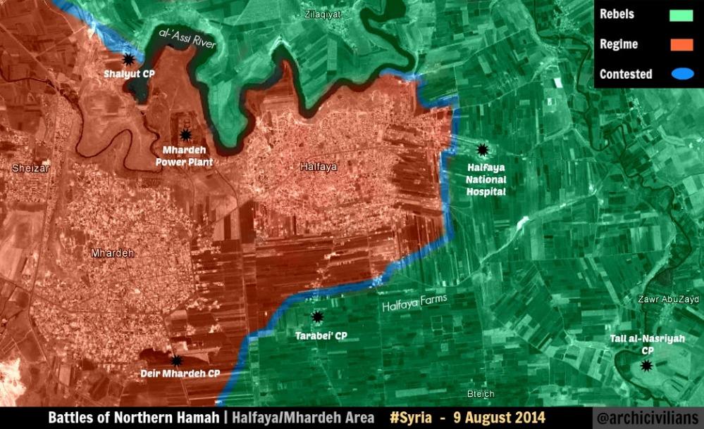
The topic is closed? Thank you, grand master. The pro-gov't sites always say that the SAA won, so that's a pointless observation. All three of those source I link say "in", not "around", yea? Why do you think that just because SOHR is ALSO reporting clashes "around" the city that that somehow negates the reports of clashes "in" the city? SOHR and SANA both say "in"! THAT is the closing of the topic. Boredwhytekid (talk) 17:10, 11 August 2014 (UTC)
- You are probably bad understand English because in the new report said that the clashes near the city but not in the city.SOHR And all your sources did not confirm that the clashes going are in the city. Hanibal911 (talk) 17:37, 11 August 2014 (UTC)
Every source I linked says "in". Every one. SANA. SOHR. Holy crap, YES, SOHR is reporting clashes around the town! But that does not negate the reports of clashes IN the town! Clashes are happening both in and around the town. That is what has been reported. Boredwhytekid (talk) 17:56, 11 August 2014 (UTC)
- Are you blind because here the map shows that the violent clashes have taken place near the city.SOHR Also SANA said that army unit thwarted terrorists’ attempt to attack a military checkpoint in Mhardeh city in the northern countryside of Hama, inflicting heavy losses upon the terrorists and destroying an armored vehicle and a car equipped with heavy machine gun. But if you see on the map all army checkpoint located of around the city Mhardeh.here and hereBut SANA not says that there clashes were in city.SANA and SOHR also said that Islamic battalions targeted regime checkpoint near the city Mhardeh.SOHR The Syria Times also said that army warded off terrorists' attack on a garrison in Mhardeh city in northern countryside of Hama.The Syria Times Hanibal911 (talk) 18:32, 11 August 2014 (UTC)
Round and round we go. We don't use pro-op sources for op gains, so stop referencing the archcivilian map, it has no pull in this conversation. The SANA article you linked, explicitly says "in Mhardeh city" - that's a direct quote - so, your "But SANA not say that there clashes were in city" is a lie. And again, yes, SOHR is reporting clashes around, but it is also reporting clashes in. They are not mutually exclusive. Both in and around can simultaneously be true. Boredwhytekid (talk) 18:48, 11 August 2014 (UTC)
- But I want offer you solution of the current situation, and now as gesture of goodwill that would not aggravate the current situation we can wait a bit and the situation will clear up by itself. Hanibal911 (talk) 18:58, 11 August 2014 (UTC)
So be it. Funny how we "wait and see", disregarding SOHR and SANA reports when it pertains to lime advances over red though. Boredwhytekid (talk) 19:05, 11 August 2014 (UTC)
Hanibal911 is clearly right. There was a single attack inside the city and was repelled. End of the story. In order to turn the city contested, either the city is splitted such that the warring sides control different parts of it or there is extensive and continuous clashes in the city (like Morek). Mhardeh doesn't fall in any of these categories. Actually turning a town contested on a single claim, creates the situation "contested for ever" so comon in the mao, because it is difficult to demonstrate that the city is not contested anymore.Paolowalter (talk) 19:09, 11 August 2014 (UTC)
And I would be completely on board with that reasoning if it was equally applied, but it's not - it's only applied to gov't territory. Otherwise why are Tasil and Adwan in Daraa still contested? Boredwhytekid (talk) 19:22, 11 August 2014 (UTC)
- After all, if you remember when we wanted changed the city Talbilesh to contested editor Tradedia said that for that would change a major city in the contested we need more information. Because it could be attack of the hit and run. Hanibal911 (talk) 19:26, 11 August 2014 (UTC)
We had the exact same situation with Khattab, Hama too though - that argument was put forward, saying that the clashes were only raids - and what happened? It ended up being switched from red to lime and never being shown as contested, because those arguing to wait and see out-shouted those who had sources confirming clashes. Boredwhytekid (talk) 19:30, 11 August 2014 (UTC)
- I think that the city Adwan we can noted under control by the rebels because at the end of May pro government source revealed that the area near the city Tasil where located the city Adwan under control of the rebels.source Hanibal911 (talk) 19:39, 11 August 2014 (UTC)
I agree, even though it's not specifically named. Boredwhytekid (talk) 20:29, 11 August 2014 (UTC)
These videos are not listed, so probably legit, its said a Islamic battalion captured a kind of base south of Mahardeh First, Second, I can find it only on this wikimap DuckZz (talk) 22:58, 11 August 2014 (UTC)
About Mhardeh status, i tend to agree with Boredwhytekid. Fighting in the last few days, reported by different sources as being inside the city, for me means it is contested. Especially considering that "contested" status is currently kept for areas that haven't seen fighting for some time now. Constantinos7 (talk) 22:39, 11 August 2014 (UTC)
Lets summ up what the sources say:
1. SANA (government) - rebel attack on a checkpoint IN the town repelled, no reports of continues fighting for the town;
2. Syriatimes (government) - rebel attack on a military garrison IN the town repelled, no reports of continues fighting for the town;
3. SOHR (neutral to slightly pro-opposition) - in first report stated fighting IN the town, but just a few hours later stated in a second report fighting was NEAR the town (newer/more up-to-date report);
4. Archicivilians (pro-opposition) - their map shows rebels on the outskirts of the town, but have not entered it yet.
For now, the best course of action would be to leave it as a red dot (government) but with a lime ring (rebel) around it. EkoGraf (talk) 02:47, 12 August 2014 (UTC)
Random Swedish source reporting the fighting in Mhardeh http://www.bahro.nu/readArticle.aspx?id=1201&catid=8 Boredwhytekid (talk) 12:30, 12 August 2014 (UTC)
- You must be joking! You need carefully look your source he is dated of 30 July. Hanibal911 (talk) 12:46, 12 August 2014 (UTC)
I didn't suggest that it was authoritative, but this is the talk page and this is the section for posting sources concerning Mhardeh, no? Why not post an old Swedish source.. the new SOHR and SANA ones are ignored. Boredwhytekid (talk) 12:54, 12 August 2014 (UTC)
- But also this you source said the largely Christian town Mhardeh in the Syrian province of Hama under attack by Islamic militants. But your source not said about the clashes in the city because it could be an attack on the city using heavy artillery or hit and run attack on the army checkpoints in vicinity of the city. Hanibal911 (talk) 13:20, 12 August 2014 (UTC)
Agree with Hanibal, source says the town is under attack but doesn't say its contested. There are dozens of towns unedr attack by the military, but only with artillery and air strikes, also these are insurgents we are talking about, hit-and-run attacks are not out of the question. EkoGraf (talk) 13:25, 12 August 2014 (UTC)
Two contemporary PRO-OPP reports about Mhardeh on syriadirect reports/news roundup sections Boredwhytekid (talk) 15:47, 13 August 2014 (UTC)
- Opposition source Syria Direct is in black listed the Wikipedia and this source prohibited for use in Wikipedia. Hanibal911 (talk) 15:59, 13 August 2014 (UTC)
Yea I noticed that it can't be linked. What's up with that? I mean it's obviously heavily pro-op, but why is it black listed? (asking out of complete ignorance) Boredwhytekid (talk) 16:05, 13 August 2014 (UTC)
- I have no idea maybe violate the some rules of Wikipedia. Hanibal911 (talk) 16:14, 13 August 2014 (UTC)
Dwebeq
SOHR reports the IS seized a number of towns, among them "Dwebeq". https://www.facebook.com/syriahroe/posts/568785449896464. I can't locate it, but these are my two best guesses: http://wikimapia.org/#lang=en&lat=36.541157&lon=37.263851&z=14&m=b , http://wikimapia.org/#lang=en&lat=36.564909&lon=37.274473&z=16&m=b Boredwhytekid (talk) 12:39, 13 August 2014 (UTC)
- Most likely source was referring the town of Duwaybiq. Hanibal911 (talk) 12:51, 13 August 2014 (UTC)
I agree, but am not certain Boredwhytekid (talk) 13:05, 13 August 2014 (UTC)
I did the same search and reached the same conclusion: Dawaybiq is the most likely candidate. Let's turn it black. Paolowalter (talk) 13:17, 13 August 2014 (UTC)
- That's the name of the city in the source Dwebeq and here the name city on the map Duwaybiq and it is name more similar than Dabiq. I added on map under control by IS the city Duwaybiq but if someone does not agree, we all can change it. Hanibal911 (talk) 13:22, 13 August 2014 (UTC)
per the same SOHR post I added al-Masoudia http://wikimapia.org/#lang=en&lat=36.495820&lon=37.342752&z=16&m=b Boredwhytekid (talk) 14:58, 13 August 2014 (UTC)
BBC also translated that SOHR post of "Dwebeq" as "Dabiq" http://www.bbc.com/news/world-middle-east-28770786. Just throwing that on here as an additional confirmation Boredwhytekid (talk) 17:35, 13 August 2014 (UTC)
Morek
SOHR is reporting that the SAA is pulling out of Morek https://www.facebook.com/syriahroe/posts/568959593212383. Just something to keep an eye on. Boredwhytekid (talk) 17:14, 13 August 2014 (UTC)
It say 'rebels took control over the southern western neighborhood in Morek Town ' We know saa still hold eastern part and Source say saa started to retreat to the outside of areas which they 'CONTROLLED 3 WEEKS AGO'(not from all morek). — Preceding unsigned comment added by 213.74.238.61 (talk) 17:32, 13 August 2014 (UTC)
Reliabilility of SOHR is far overestimated in this page. It just gets report from rebels (I doubt there are civilians in Morek now). In any case the report is written in bad english and difficult to understand. At most it means that SAA retreated by the south-western neighborhood to its previosu positions. Honestly, nobody on Twitter is posting this news even from the rebel side, even if many announced SAA retreat from Morek several times in the past.Paolowalter (talk) 18:49, 13 August 2014 (UTC)
121st Artillery Regiment and al-Melebiya
Pro opposition kurdish source said that militants of the Islamic State are withdrawing slowly from 121 Artillery Regiment and heading to the town of al-Hawl in the eastern countryside of al-Hasakah province, after transporting wheat and corn from al-Melebiya Grain Center.Ara News Hanibal911 (talk) 20:51, 13 August 2014 (UTC)
Ayyash
I think Ayyash (near Deir Ezzor) should be changed to black and red alternating squares. I keep seeing it change back and forth. — Preceding unsigned comment added by Wethrman2 (talk • contribs) 16:41, 12 August 2014 (UTC)
No it is black. I changed some time ago backed up by sources but it was changed to red without a reason. It should be changed black again.Paolowalter (talk) 16:56, 12 August 2014 (UTC)
It's still red on the map. — Preceding unsigned comment added by Wethrman2 (talk • contribs) 17:15, 12 August 2014 (UTC)
Sources were provided at the time indicating it was SAA-held. EkoGraf (talk) 18:42, 12 August 2014 (UTC)
Tons of sources plus extensive visual evidences Ayyash is controlled by Army here = https://en.wikipedia.org/wiki/Talk:Cities_and_towns_during_the_Syrian_Civil_War#Ayyash_is_in_Government_control_stop_to_change_that_to_black. --Pototo1 (talk) 22:24, 13 August 2014 (UTC)
ar Ruhaybah
According to pro opposition source ar ruhaybah under army control near qutayfah https://pietervanostaeyen.files.wordpress.com/2014/08/2000px-syria5.png — Preceding unsigned comment added by 213.74.238.61 (talk) 17:24, 13 August 2014 (UTC)
source is from January 8 2014? Boredwhytekid (talk) 17:49, 13 August 2014 (UTC)
source is from august 1 2014 (01-08-2014) look carefully(the upper right corner) https://twitter.com/arabthomness/status/495286314351468544 213.74.238.61 (talk) 17:55, 13 August 2014 (UTC)
you're right - my mistake - I read that backwards Boredwhytekid (talk) 18:01, 13 August 2014 (UTC)
- Friends maybe pro government source was mistaken concerning the city of Al Ruhayba because pro opposition source on 1 August showed that the city is under the control of the army and not have any messages that he was captured by the rebels. Here for example in relation to the town of Zabadani have been many reports of SOHR about the air raids near town and in the city itself. So I propose to return the city to the under control of the army if there is no other evidence that he was captured by rebels. Also here another opposition source on 8 August also noted the city of Al Ruhayba under army control. So I think that pro government source make mistake when marked Al Ruhayba to under rebel control. Hanibal911 (talk) 18:29, 13 August 2014 (UTC)
Well to my knowledge rebels never made it inside the town also would note that the town is placed in between military bases making it hard to belive that the town is rebel held especialy when the brigade 81 is bordering the town I think the town should be reverted to red as there have never been reports of it in rebel hands also the lack of fighting in the area suggests that there are is no actual presence of rebels there.There have been 0 reports of fighting in the town for a year or maybe more and that is hard to belive when you have brigade 81 just outside the town.Daki122 (talk) 18:43, 13 August 2014 (UTC)
Please go ahead Al-Ruhayba back to red. On the other hand Jayroud may be on truce rather than fully red.Paolowalter (talk) 18:49, 13 August 2014 (UTC)
I agree with Hanibal's statement. While we're in this spirit though, can something be done about Tasil and Adwan? No reports of conflict there in quite some time, rebels have moved on and seized military checkpoints/bases to the north, and there really isn't any indication at all that fighting is continuing. Especially Adwan. Both pro-op maps posted above show Tasil/Adwan rebel controlled too.. (I know, no pro-op source for pro-op gains, but still.. all evidence points towards these towns being rebel held) Boredwhytekid (talk) 18:53, 13 August 2014 (UTC)
- I think that we can note the city Al Ruhayba under control of the army and the city Adwan to under rebel control because the pro-government and pro opposition sources have revealed that the area where located the city Adwan under rebel control. pro government source 9 December 201321 May 2014 Hanibal911 (talk) 19:13, 13 August 2014 (UTC)
Well I don't know about Adwan but there have been reports of clashes in Tasil even SOHR reports it.Daki122 (talk) 21:23, 13 August 2014 (UTC)
I'm not so sure about this. I think Adwan should stay constested and Tasil to green, mainly because both towns are being shelled but the difference is that the Syrian army targets Adwan with mortars and Tasil with aircraft and barrel bombs, and that means they are to far from the city. As for Ruhaybah. Does anyone have a source that rebels withdrew from this city ? This video shows FSA presence in the city, and SAF aircraft above. There is not much info about the city from this year because clashes were held mainly around Dumayr and the desert, the town stayed in some kind of truce. So my suggestion is : Adwan constested, Ruhhaybah truce or red surrounded, Tasil green DuckZz (talk) — Preceding undated comment added 21:33, 13 August 2014 (UTC)
- It is not necessary to invent and to stop provide as the source every trash taken from YouTube because amateur video from YouTube by the rules Wikipedia is not a reliable source and is not used for editing. Also here an pro opposition source on 1 August showed that the area which located the city Al Ruhayba under control of the army. Also here another pro opposition source on 8 August also showed that the city Al Ruhayba under control of the army. Hanibal911 (talk) 06:30, 14 August 2014 (UTC)
New ISIS gains in northern Aleppo
On Wednesday, Syrian opposition activists told the Associated Press that Islamic State fighters captured the towns of Akhtarin and Turkmanbareh in the Aleppo countryside near the border with Turkey, dislodging other rebels in the process.
http://www.foxnews.com/world/2014/08/13/syrian-forces-reportedly-close-to-encircling-key-rebel-city-aleppo/ — Preceding unsigned comment added by 77.240.103.2 (talk) 11:24, 13 August 2014 (UTC)
- + maybe some other gains but we should wait for confirmation - https://twitter.com/PetoLucem/status/499502785956941824 — Preceding unsigned comment added by 77.240.103.2 (talk) 11:28, 13 August 2014 (UTC)
Some usually reliable sources from Twitter indicate, that ISIS have taken Sawran near Azaz. Unfortunately I did not find any media source, but we should observe the situation. https://twitter.com/markito0171/status/499647571045134336 https://twitter.com/arabthomness/status/499679909691019264 https://twitter.com/TahrirSy/status/499641072650575872 — Preceding unsigned comment added by 109.123.211.49 (talk) 07:16, 14 August 2014 (UTC)
al Sha'er, Homs
SOHR is still reporting clashes around al Sha'er https://www.facebook.com/syriahroe/posts/569073499867659. We need to show it on the map somehow - because right now we don't show the IS within 200mi of al Sha'er, and that is false. Black semi-circle to the northeast? Boredwhytekid (talk) 12:24, 14 August 2014 (UTC)
- To be precise SOHR not said around it said that violent clashes took place between the IS fighters and the regime forces near Al Sha’er oilfield in the eastern countryside. But when source saide that clashes in eastern countryside it does not mean that the clashes go around you need carefully read the source.source Hanibal911 (talk) 12:48, 14 August 2014 (UTC)
Fair enough. How can we make the map more accurate with this though? There's long been an IS presence stretching from southern Raqqa through eastern Hama province and northeastern Homs province, but it's in the wastelands/wilderness primarily Boredwhytekid (talk) 13:09, 14 August 2014 (UTC)
Here is a list of previously not covered places/towns in this area:
- Al Kadir 35°16'21"N 38°50'39"E (Maybe ISIS)
- El Kowm Oasis 35°12'12"N 38°51'26"E (Unknow)
- Bi'r Tuwaynan 35°2'58"N 38°19'40"E (ISIS but confirmation needed)
- Abokald Village 35°7'50"N 37°57'14"E (Unknow)
I think this is good a good start.
Updated the SAA gains in Aleppo and Mleiha
Pro and anti government sources report Army advances in Aleppo https://en.wikipedia.org/wiki/Template_talk:Syrian_Civil_War_detailed_map#News_small_gains_for_Army_in_Aleppo_zone
https://www.zamanalwsl.net/en/news/6125.html
But in no see changes in west Aleppo map
__
The map from Damascus should be updated too and put the North of Mleiha in red
https://www.zamanalwsl.net/en/news/6127.html
Most sources are anti government how you can see
Please updated these changes when you get time
Thanks --Pototo1 (talk) 22:30, 13 August 2014 (UTC)
According to army sources, saa capture full of maliha this morning. https://www.facebook.com/hosienmortadapressnew/posts/939251129433720 https://www.facebook.com/dnno1/posts/751694611536501 https://www.facebook.com/ktaybalbath3/posts/1522496017981342 https://www.facebook.com/page.F.S.N.N/posts/705196772850703
But we need to wait for pro opposition sources.213.74.232.195 (talk) 08:06, 14 August 2014 (UTC)
And sohr confirmed.Maliha fully under army control. http://syriahr.com/index.php?option=com_news&nid=21997&Itemid=2&task=displaynews .We need to fix to map.213.74.232.195 (talk) 08:18, 14 August 2014 (UTC)
And please , fix to ,jarba - qasimiyah - qaysa - abbadeh too.source:http://www.dailystar.com.lb/News/Middle-East/2014/Feb-25/248401-un-resolution-brings-little-change.ashx#axzz2sk38sDRI .source say railway is frontline.It makes jarba - qaysa -qasimiyah and abbadeh under army control.Thanks213.74.232.195 (talk) 08:25, 14 August 2014 (UTC)
For Maliha, another source - http://www.lbcgroup.tv/news/172115/syrian-army-takes-town-outside-damascus-report — Preceding unsigned comment added by 109.123.211.49 (talk) 08:27, 14 August 2014 (UTC) http://uk.reuters.com/article/2014/08/14/uk-syria-crisis-town-idUKKBN0GE0MN20140814 — Preceding unsigned comment added by 109.123.211.49 (talk) 08:30, 14 August 2014 (UTC)
I just wrote on https://en.wikipedia.org/wiki/File_talk:Rif_Damashq.svg#Maliha_and_east_Ghouta to suggest the changes in Maliha and surrounding cities. There are probably also changes on the east border of the map to be applied. Try to push the editor to implement quickly these changes.Paolowalter (talk) 10:29, 14 August 2014 (UTC)
SOHR - SAA controls nearly all of Mleiha https://www.facebook.com/syriahroe/posts/569238463184496 Boredwhytekid (talk) 12:20, 14 August 2014 (UTC)
The Army has taken full control of the town of Mleha SOHR-[8].Daki122 (talk) 14:35, 14 August 2014 (UTC)
Azaz
In according the some data the leader of a major rebel brigade, Abu Obaida Al Masri, gave his troops orders to withdraw from the town of Azaz. According to activists in the area, Al Masri withdrew his forces to avoid fighting Islamic State.Al Jazeera Hanibal911 (talk) 18:46, 14 August 2014 (UTC)
Tall Ma'ruf
Based on which source pro-Bashar editors changed Tall Ma'ruf to contested? Is it sourced?? Roboskiye (talk) 16:55, 14 August 2014 (UTC)
- You better indicate the source on the basis of which you marked the village Tall Ma'ruf under control by Kurds. And by the way, I never did not noted the village Tall Ma'ruf to contested. But these villages previously were contested between Kurds and IS.here Hanibal911 (talk) 17:12, 14 August 2014 (UTC)
- NO, my edit is already reverted to your unsourced version. It's YOUR job to provide a source which places Tal Maruf as contested. Roboskiye (talk) 17:17, 14 August 2014 (UTC)
- Because these villages previously have been marked as contested on based data from reliable sources. Hanibal911 (talk) 17:40, 14 August 2014 (UTC)
- Roboskiye was right I looked the history of map editing and found a mistake! On 13 July the editor Ahmetyal noted the village Tall Maruf to contested and also add the village Eastern Palestine and noted it as contested on based data the Kurdish source.here But he was wrong in the source did not said that in these villages clashes in the source only says that Islamic militants shelled the villages of heavy artillery and tanks. Hanibal911 (talk) 08:12, 15 August 2014 (UTC)
- Good. I'm still pretty sure there are no clashes in Tal Alo, Jaza and Tel Kocher. But unfortunately there are not many sources to clarify the current situation, with exception of pro-YPG websites. Roboskiye (talk) 08:48, 15 August 2014 (UTC)
- Roboskiye was right I looked the history of map editing and found a mistake! On 13 July the editor Ahmetyal noted the village Tall Maruf to contested and also add the village Eastern Palestine and noted it as contested on based data the Kurdish source.here But he was wrong in the source did not said that in these villages clashes in the source only says that Islamic militants shelled the villages of heavy artillery and tanks. Hanibal911 (talk) 08:12, 15 August 2014 (UTC)
- Because these villages previously have been marked as contested on based data from reliable sources. Hanibal911 (talk) 17:40, 14 August 2014 (UTC)
- NO, my edit is already reverted to your unsourced version. It's YOUR job to provide a source which places Tal Maruf as contested. Roboskiye (talk) 17:17, 14 August 2014 (UTC)
al-Aziziyah and Al Hamidiyah
Source Al Monitor said that IS captured the villages of al-Aziziyah and Al Hamidiyah but these villages located in the southeastern part of the Aleppo province here in area which under rebel control.Al Monitor And SOHR also said that IS captured the village Al Aziziyah.here Who has any suggestions on this issue! Hanibal911 (talk) 09:42, 15 August 2014 (UTC)
My bet is that they are talking about here http://wikimapia.org/#lang=en&lat=36.531812&lon=37.312240&z=15&m=b Boredwhytekid (talk) 12:13, 15 August 2014 (UTC)
- Yes you are right! Thanks to the editor Boredwhytekid we found the village al-Aziziyah but still we need to find the village Al Hamidiyah. Hanibal911 (talk) 12:22, 15 August 2014 (UTC)
Kurdish villages on north Raqqa province
Pro-opposition Kurdish source claimed that villages of Kendal, Bir kino, Koperlik, Hawalik, Koshkar, Hashasho and Huriya, west of Tel Abyad under control by YPG.Ara News Some of these villages now noted under control by IS. Somebody of the editors has more data about the situation in these villages and who actually controls them? Because the Kurds claim that they control the area where located these villages and are preparing for an extended military operation against IS militants to regain control over the city Tel Abyad. Hanibal911 (talk) 13:53, 15 August 2014 (UTC)
Mare' / Marea, Aleppo
On what basis is Mare' / Marea encircled by the IS? If it's being shelled, it's only from the east, so that's what the black circle should indicate. Boredwhytekid (talk) 14:18, 15 August 2014 (UTC)
- SOHR said that ISIS targeted town Mare' with mortars, reports of wounding a child, a man was killed by clashes against ISIS around Mare'.source Hanibal911 (talk) 14:54, 15 August 2014 (UTC)
Would you move the black circle to indicate that the IS is only attacking from the East? Boredwhytekid (talk) 15:03, 15 August 2014 (UTC)
Sawran
Some pro opposition sources said that IS captured the city Sawran(Suran) in the Aleppo countryside.arabthomnessTahrirSy But I dont know we can use this data because they taken from Twitter. Waiting for your offers. Hanibal911 (talk) 08:57, 14 August 2014 (UTC)
- Pro-op eaworldview reports IS "were reported in Suran, east of Azaz, last night" http://eaworldview.com/2014/08/syria-daily-insurgents-doomed-aleppo/ Boredwhytekid (talk) 12:12, 14 August 2014 (UTC)
- SOHR said that violent clashes have occurred between IS fighters and the Islamic and rebel battalions in the vicinity of Ehtimlat village and the township of Soran E’zaz. But it is not clear exactly where the collision or in the Soran or Azaz or in the villages between the two cities. But i think that we need put green circle around the village Ehtimlat which now under IS control.source Hanibal911 (talk) 13:10, 14 August 2014 (UTC)
I agree. A green semi circle to the west of Suran is probably appropriate too Boredwhytekid (talk) 13:15, 14 August 2014 (UTC)
- Agree! But you can do it yourself or I do it? Hanibal911 (talk) 13:22, 14 August 2014 (UTC)
 Done I've added both Boredwhytekid (talk) 13:39, 14 August 2014 (UTC)
- Remains unclear the situation with the city Sawran(Soran). Here are the data that show that ISIS bombardment with mortars on Sawran(Soran).here Hanibal911 (talk) 15:04, 15 August 2014 (UTC)
It seems we jumped the gun. If they are bombarding it, Sawran(Soran) should be lime with a black ring to the East Boredwhytekid (talk) 15:06, 15 August 2014 (UTC)
- But taking into account all the data I think it would be better to note it as a contested. Hanibal911 (talk) 15:21, 15 August 2014 (UTC)
Updated Meliha in Damascus map
News are emerging from a SAA capture of Al-malelah from the FSA. In some days it will be corroborated by News Agencies and Sohr. I will Keep an eye on it.200.48.214.19 (talk) 17:38, 14 August 2014 (UTC)
https://translate.googleusercontent.com/translate_c?depth=1&hl=es&ie=UTF8&prev=_t&rurl=translate.google.com&sl=ar&tl=en&u=http://syriahr.com/index.php%3Foption%3Dcom_news%26nid%3D22006%26Itemid%3D2%26task%3Ddisplaynews&usg=ALkJrhgisVZk-A3Z5BXDiv4C1Y7bHLHWRA200.48.214.19 (talk) 17:41, 14 August 2014 (UTC)
- Already confirmed by SOHR. EkoGraf (talk) 19:13, 14 August 2014 (UTC)
Dude if SOHR (No reliable Source) claim any bullsh1t you go fast in fews second to edit their claim lol but if you get huge evidences from others sources you did nothing after 24+ hours
alikhbaria TV Al Madayeen TV SANA SAMA TV NDF Press Office
Lebanon Al Jadeed Lebanon Al Madayeen 1 Lebanon Al Madayeen 2 Inside the Insurgent Meliha Tunnels
AFP Gulf Times Los Angeles Times
More sources http://www.lbcgroup.tv/news/172115/syrian-army-takes-town-outside-damascus-report http://uk.reuters.com/article/2014/08/14/uk-syria-crisis-town-idUKKBN0GE0MN20140814 --Pototo1 (talk) 15:35, 15 August 2014 (UTC)
Ras al-Maarra, Qalamoun
This pro-gov't source shows rebels advancing towards Ras al-Maarra from the southwest https://twitter.com/PetoLucem/status/499490650812080129/photo/1. SOHR reports barrel bombing in the "wasteland of Ras al-Maarra" (to the southwest of the town) https://www.facebook.com/syriahroe/posts/568943429880666. Pro-gov't al-Wahda reports that an attack was repelled in Ras al-Maarra http://thawra.alwehda.gov.sy/_kuttab_a.asp?FileName=31590954220140813010445. Pro-op Qalamoun Media Center reports rebel advances in Ras al-Maarra https://www.facebook.com/Qalamon.MC9/posts/754689284595211. Pro-op eaworldview reports rebels took "two checkpoints and four barracks in Ras al-Maraa" http://eaworldview.com/2014/08/syria-daily-insurgent-counter-aleppo-defeats-victories-elsewhere-patchwork-war/.
Here is the town http://wikimapia.org/#lang=en&lat=33.998967&lon=36.555805&z=14&m=b. There's obviously some fighting going on around this place. I propose that Ras al-Maarra be added as a red dot, and a lime semi-circle ONLY to the southwest of Ras al-Maarra. Boredwhytekid (talk) 13:18, 15 August 2014 (UTC)
Not how it works. The circle is there if there is clashes on the outskirts of the town, the town is besieged or if the town is shelled. None of this is occurring. Source talks about fighting in the wastelands of the town, which as far as we can know is kilometers away (large desolate area west and southwest of it) and not in the outskirts. And the Qalamoun media center and eaworldview are excluded as sources by default from the start. And that Peto Lucem map shows the rebels a good half a dozen or more kilometers west of the town. EkoGraf (talk) 13:30, 15 August 2014 (UTC)
The pro-gov't al-Wahda report meets your criteria. As does a SANA report from late July http://www.sana.sy/en/?p=8170 stating the army "continued operations in.. the towns of al-Mesherfeh and Ras al-Maarra, killing several terrorists" - that's SANA talking about clashes IN the town last month.
Technically, by the editing rules, that SANA report is the latest valid source we have as to who controls the town - and by that logic we should add it as contested. But that isn't true, so I am proposing we do the reasonable thing and add it as the situation on the ground truly is.
It is gov't held and there are clashes on the outskirts to the southwest now.. Boredwhytekid (talk) 14:05, 15 August 2014 (UTC)
- Now in this area there goes a joint operation of the Syrian and the Lebanese army with the support of Hezbollah. And the rebels basically commit attacks hit and run! If in a situation with the city of Assal Al Warad pro government map showed that the clashes go is not far from the city. But in a situation with the city of Ras al Mara map showed that the clashes go are far from the city. Hanibal911 (talk) 14:16, 15 August 2014 (UTC)
Look, that SANA report is the latest one we have to validate the situation in Ras al-Maarra - I can add it as contested on the basis of that source and be 100% in the right as goes the editing rules. I am trying to compromise and show the truth. Boredwhytekid (talk) 14:22, 15 August 2014 (UTC)
- But pro opposition source also showed that on 3 August that clashes go outside the city.here and pro government source on 13 August showed that clashes go in few miles from the city.here Hanibal911 (talk) 14:49, 15 August 2014 (UTC)
But that pro-rebel map shows them right outside of the city, and the pro-gov't one shows them attacking towards it. Both support that it's gov't held, and the front line is on the outskirts to the southwest. 146.184.160.23 (talk) 14:59, 15 August 2014 (UTC)
The SANA report says they are conducting operations in the town, which can as well mean they are conducting raids on rebel hideouts and in the process killing or arresting insurgent operatives. These are insurgents after all who work undercover from the underground. The report does not say at any time that there is an ongoing battle for the town, while we have SOHR itself saying and the pro-rebel map showing the town is government-held. EkoGraf (talk) 15:47, 15 August 2014 (UTC)
- I agree with EkoGraf. Hanibal911 (talk) 15:55, 15 August 2014 (UTC)
village B'eden in Aleppo province
IS have taken over the village of B'eden near al-Ra'ii town which is also under control by IS in the northern countryside of Aleppo near Syria -Turkey borders.SOHR Who knows where located this village on the map. Hanibal911 (talk) 15:44, 15 August 2014 (UTC)
real name is bagheden. location: http://wikimapia.org/#lang=tr&lat=36.656318&lon=37.303090&z=15&m=b195.155.232.224 (talk) 17:04, 15 August 2014 (UTC)
Al-Masrab in Deir ez Zor province
Opposition news agency, said the Islamic State continued its assault village Al Masrab, a third village controlled by the regime in the western countryside. But source not say that the militants Islamic State captured the village. Do someone else from editors have data about the situation in this village.The Sacramento BeeMiami HeraldMc Clatchy Dc Hanibal911 (talk) 17:28, 15 August 2014 (UTC)
- SOHR last month - mentions it in the 2nd line https://www.facebook.com/syriahroe/posts/556874567754219 Boredwhytekid (talk) 17:45, 15 August 2014 (UTC)
- But SOHR reported about situation in this village on 18 July. But this sources The Sacramento BeeMiami HeraldMc Clatchy Dc claimed on 22 july that Islamic State not yet captured this village. And they got this information from the opposition news agency. So that their information is newer and more urgent. Hanibal911 (talk) 18:05, 15 August 2014 (UTC)
- This dubious blog source is the only other reference I've come across http://malcolmxtreme.wordpress.com/2014/08/11/8112014/ Boredwhytekid (talk) 18:15, 15 August 2014 (UTC)
Names of some villages and towns
seems some one doing vandalism and delete parts of these towns in Hasakah https://www.facebook.com/syriahroe/posts/562706100504399 please relocated that --Pototo1 (talk) 04:11, 13 August 2014 (UTC)
- Often editor Tradedia revert editings because he believes that if the name of the object on the map and in the source does not match on 100% we do not need to edit this city or village. Here he revert my edit because he said that Al Marfu`ah is not the same as Al Ma’ruf and Ali al Fallah is not the same as Al Fallaha. But we all know that very often some of the sources including SOHR indicate the name of the towns or villages is not quite as it appears on the map. I think everyone will agree with me! Hanibal911 (talk) 06:57, 14 August 2014 (UTC)
- I understand that there are many different ways to transliterate an Arabic name into English. However, an Arabic speaker will recognize that Al Marfu`ah = مرفوعة is very different from Al Ma’ruf = معروف. Ma’ruf means “known”. On the other hand Marfu`ah means “raised”. Also, `Ali al Fallah = الفلاح علي is very different from Al Fallaha = فلاحة . Al Fallaha means the “woman farmer”. On the other hand `Ali al Fallah means “Ali the farmer”.
- Also, there is not just the name to take into account. You have to look at the geographic location. You put the dot for Al Marfu`ah based on geonames.org. However, you can see on the map that it must be a mistake, because at that location, there is no village, not even a house. It is literally in the middle of the desert!
- You had already put Al Slaleyyi & Al Homor in the wrong place and you were corrected by another editor. This should have told you that your work methodology has problems in it. The source said: “The Islamic battalions retreated from areas in the south- east of Al Hasaka city, where the regime forces advanced and took control over the villages of Al Homor, Al Slaleyyi, Al Fallaha, Al Ma’ruf and Al Maqbara reaching to the old junction of Al Shaddadi.” After we put on our map the correct location of Al Slaleyyi & Al Homor, you can see that the army advance is rather close to Hasaka city as the source indicated. The places where you put Al Marfu`ah & `Ali al Fallah are very far from them. Moreover, `Ali al Fallah is way south of Al Shaddadi, which is not at all consistent with the source. The army made an advance “reaching to the old junction of Al Shaddadi.”
- As of now, our map looks stupid with these 2 red dots deep in the middle of ISIS territory. Why would the army go to the middle of the desert at Al Marfu`ah where there is not even a house!? And do you think the army would be in `Ali al Fallah very deep into ISIS territory, and very far away from their supply lines?
- All the above elements clearly show that the 2 dots that are now on the map cannot be the villages that are talked about in the source. Also, I want to note that you were about to make the same mistake here: #al-Aziziyah and Al Hamidiyah. And you made the same mistake here and here. It is not enough to do a search on a name in a source and then pick a similar name and just put the dot on the map. We need to be more careful about the context and the geography. Tradediatalk 02:09, 16 August 2014 (UTC)