
Talk:Control of cities during the Syrian civil war/Archive 25
| This is an archive of past discussions. Do not edit the contents of this page. If you wish to start a new discussion or revive an old one, please do so on the current talk page. |
| Archive 20 | ← | Archive 23 | Archive 24 | Archive 25 | Archive 26 | Archive 27 | → | Archive 30 |
Wadi Barada
Why has the rebel presence from this area (valley NW of Damascus) been removed from the map?Jafar Saeed (talk) 23:39, 8 September 2014 (UTC)
- This pro-opp map -https://twitter.com/arabthomness/status/506900833087528960 - does not show it, so it was removed [not by me]. 2602:30A:C01B:89F0:4C1F:A767:8E14:8CED (talk) 00:24, 9 September 2014 (UTC)
This map is very rough. The presence of rebels in the valley is likely still there. E.g. https://twitter.com/Isham_AlAssad/status/509145609023275008/photo/1 reports surrendering of rebels from Wadi Barada. The same mistake must be corrected on the Damascus map. Unless there are sources supporting the changes, of course.Paolowalter (talk) 12:08, 9 September 2014 (UTC)
- Such maps are sometimes was mistaken and here confirmation for my words: Map from Reuters on 3 July 2014 said that the city of Maydaa in mostly under government control. But many other source said that in this town was clashes Syrian rebels against IS and Syrian troops no present in this city. So that we need more data. Hanibal911 (talk) 07:02, 10 September 2014 (UTC)
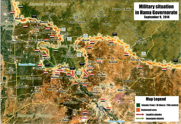
Updated map Rural Hama September 09
This are Peto Lucem pro Government map but credibility is good he is many times is right https://pbs.twimg.com/media/BxGj196IEAAQMlE.jpg
It showing Halfaya under Army control.
But I think is better wait for more info anyway. --Pototo1 (talk) 21:19, 9 September 2014 (UTC)
Pro-gov sources cannot be used to make government advances. — Preceding unsigned comment added by 85.112.86.30 (talk) 22:11, 9 September 2014 (UTC)
no, it doesnt show Halfaya under army control, and it isnt. — Preceding unsigned comment added by 132.231.182.130 (talk) 06:30, 10 September 2014 (UTC)
It shows Halfaya contested. That is what I argued yesterday but it was not accepted. Let's wait more news. Paolowalter (talk) 08:21, 10 September 2014 (UTC)
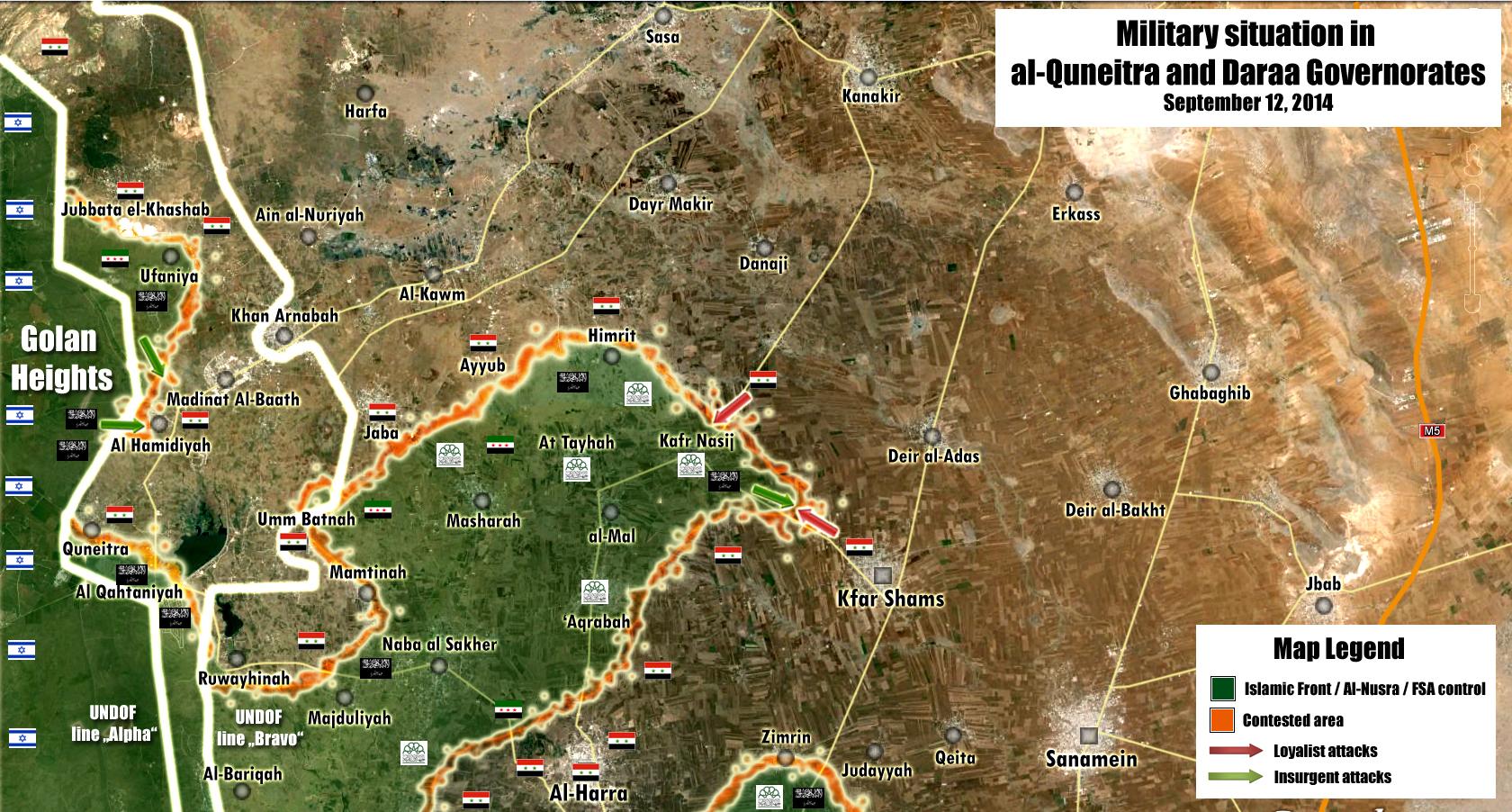
Daraa and Quneitra
According to sohr Al nimr under SAA control and Kafar Nasej, al-Taiha, Aqraba under al Nusra control source: https://www.facebook.com/syriahroe/posts/581243318650677AWBW (talk) 08:27, 10 September 2014 (UTC)
And according to pro opp map zimrin under SAA control http://umap.openstreetmap.fr/fr/map/desyracuse-syria-civil-war-8-september-2014_16140#13/33.0345/36.0855AWBW (talk) 09:06, 10 September 2014 (UTC)
Zimrin should be contested or green. Multiple neutral sources from August claiming fighting in the area:
- http://news.yahoo.com/syria-army-kills-32-rebels-daraa-province-ambush-141805650.html
- http://zeenews.india.com/news/world/50-rebels-killed-in-syrian-army-ambush_957025.html
- http://zeenews.india.com/news/world/syria-army-kills-32-rebels-in-daraa-ambush-ngo_957059.html
- http://zeenews.india.com/news/world/50-rebels-killed-in-syrian-army-ambush_957025.html
- http://live.aljazeera.com/Event/Syria_Live_Blog/124864849
So I suggest making Zimrin green, as this is just a Twitter map your referring to, not a real source. We don't use Twitter. — Preceding unsigned comment added by 84.24.43.183 (talk) 11:59, 10 September 2014 (UTC)
- I urge you to watch Zimrin. It was changed to red based on the desyracuse map, which, again, is a random individual's map used for pro-gov't edits regardless of what mainstream media is reporting. Boredwhytekid (talk) 12:28, 10 September 2014 (UTC)
I follow several maps. desyracuse has nice maps, but most of the times he is behind the news. For example: in his map, Nimr is rebel held, but it is proven by SOHR itself that is is SAA held. Also, he shows two rebel advances like a pincer, while sources on this page have already confirmed that the entire front is moving. If you compare him to other maps like Archivilians, Thomas van Linge of Arab Chronicle, he has several severe mistakes ... I personaly think desyracuse is the least updates and gifted pro-opposition map maker :) — Preceding unsigned comment added by 84.24.43.183 (talk) 12:33, 10 September 2014 (UTC)
zimrin should green but i think desyrcuse maps better than other pro opp. maps :)Hwinsp (talk) 13:35, 10 September 2014 (UTC)
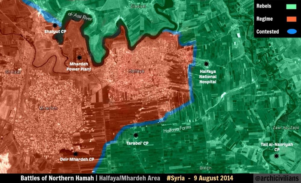
Halfaya
sohr says clashes between saa and nusra in halfaya national hospital and outskirts of halfaya.I suggest put a red circle around halfaya source : http://www.syriahr.com/index.php?option=com_news&nid=23275&Itemid=2&task=displaynewsHwinsp (talk) 13:08, 10 September 2014 (UTC)
- Agreed - remove the green circle from around Mhardeh too please Boredwhytekid (talk) 13:12, 10 September 2014 (UTC)
- Halfaya contested obviously. It is so since yesterday.
- On the other hand Zimrin stays green or at most contested. The map from desyracuse
is not very precise in general.Paolowalter (talk) 13:38, 10 September 2014 (UTC)
- Halfaya national hospital located inside the city Halfaya Hanibal911 (talk) 13:47, 10 September 2014 (UTC)
- I Agree with editor Paolowalter in situation with the city of Zimrin! Hanibal911 (talk) 13:50, 10 September 2014 (UTC)
- Halfaya national hospital located inside the city Halfaya Hanibal911 (talk) 13:47, 10 September 2014 (UTC)
Idk man.. http://wikimapia.org/#lang=en&lat=35.261507&lon=36.629326&z=19&m=b that hospital is inside Halfaya the same way that powerplant is inside Mhardeh - not really.. Boredwhytekid (talk) 13:54, 10 September 2014 (UTC)
- Look closely and you will see that Power plant located outside the city Mhardeh in area between the city of Halfaya and the city of Mhardeh and Wilimapia it clearly shows. Pro opposition map also showed it is. here Hanibal911 (talk) 14:10, 10 September 2014 (UTC)
I know - but look, that hospital is the same distance from Halfaya proper as the power plant is front Mhardeh proper Boredwhytekid (talk) 14:12, 10 September 2014 (UTC)
Many twitters states that Bteish and Halfaya were taken by SAA e.g.https://twitter.com/deSyracuse/status/509725756684263424 .Paolowalter (talk) 15:36, 10 September 2014 (UTC)
Continued fighting https://www.facebook.com/syriahroe/posts/581388908636118 Boredwhytekid (talk) 16:12, 10 September 2014 (UTC)
Just for info: https://www.facebook.com/syriahroe/posts/581438378631171 South Halfaya under SAA control. Paolowalter (talk) 19:34, 10 September 2014 (UTC)
Following http://www.almasdarnews.com/article/tiger-forces-capture-tal-nasariyyah-west-hama/ also Bteish is under control by SAA (Tell Batesh). Paolowalter (talk) 19:51, 10 September 2014 (UTC)
Quneitra
Some info on status of Quneitra in http://www.al-monitor.com/pulse/originals/2014/09/syria-golan-rebels-attack-control-quneitra.html. We should try to decode it understanding if it can help.Paolowalter (talk) 20:56, 10 September 2014 (UTC)
From this article we can solve our previous discussion: Zimrin is controlled by government. It is listed with al-Harra, al-Sanamayn, al-Jidiya (all controlled by government) as towns where reinforcements are grouped. It goes red (congratulation to deSyracuse :-) ).Paolowalter (talk) 21:04, 10 September 2014 (UTC)
And we can also solve many towns that need to go to green, based on this article:
- Quneitra city
- Qathaniya
- Al-Mal (on this map already surrounded by rebel held villages)
And half-green ring showing fighting nearby:
- Khan Arnabah
- Madinat al-Baath — Preceding unsigned comment added by 84.24.43.183 (talk) 21:23, 10 September 2014 (UTC)
- Al Monitor said that city Qathaniya under rebel contol and source said that rebels take control of the old city of Quneitra near border crossing which had been completely destroyed by Israel before its withdrawal in 1974.Al Monitor And rebels captured Tell al Mal military object but not village Al Mal.SOHR Also pro opposition source confirmed that rebels still not taken the new city Al Quneitra they are now only aiming for city Al Quneitra. www.syriadirect.org/rss/1546-new-update-9-9-14 Hanibal911 (talk) 21:44, 10 September 2014 (UTC)
The rebels have not taken Al Mal? Really? How they would control a hill JUST OUTSIDE the village and many villages nearby and not the village itself? And Al-Monitor have mentioned Quneitra city to be under rebel control, so at least change it to contested. — Preceding unsigned comment added by 186.212.61.161 (talk) 22:21, 10 September 2014 (UTC)
- Please learn to read, Al-monitor said A REBEL ACTIVIST CLAIMED THAT THE REBELS HAVE taken Quinetra City. 2602:30A:C01B:89F0:4C1F:A767:8E14:8CED (talk) 00:10, 11 September 2014 (UTC)
Please learn how to think. How in the world the rebels have taken Tell Al-Mal and not Al-Mal? How have they not conquered the areas in middle of Quneitra, have their soldiers teleported? You guys are pathetic — Preceding unsigned comment added by 186.212.61.161 (talk) 00:48, 11 September 2014 (UTC)
- Here are the simple rules on Wikipedia, get a reliable source or stop complaining. We have our source [Al-Monitor]. I am sorry if you cannot read it due to your illiteracy. Also, in regards to your "have their soldiers teleported?" comment, you forget that these are insurgents, infiltration is a habit of theirs. Seriously, why is it so hard for you to get a source instead of complain since you seem so sure of yourself? If you don't like the map here, you are always welcome on ArchieveCivilans maps.2602:30A:C01B:89F0:4C1F:A767:8E14:8CED (talk) 01:27, 11 September 2014 (UTC)
- Editor 84.24.43.183 you are already bored with your delusional statements that are based on your violent fantasies and more than anything. So if we follow your logic, we should also note under rebel control the citys Al Zahraa and Nubl in the Aleppo province , which are currently under the control of the army but are surrounded by rebels. We cant edit map only based on your desires and fantasies. The same applies to you, anonymous editor which IP adress 186.212.61.161 your logic very funny but we also cant edit the map based to your guesses! And for the future carefully read the sources before you making unfounded statements. Because SOHR clear said that rebels captured hill Tall al Mal which located on west from the village Al Mal for a distance of two kilometers and also source clear said that rebels captured old city Quneitra near border which had been completely destroyed by Israel before its withdrawal in 1974.Al Monitor But New city Quneita which located to the east at a distance of 20 kilometers.The Daily Star And pro opposition source reported that now rebels prepare to attack this city.www.syriadirect.org/rss/1546-new-update-9-9-14 Hanibal911 (talk) 04:49, 11 September 2014 (UTC)
Tasil, Daraa
Is this town really contested ? The town was rebel held, clashes erupted in May between the SRF,IF on one side and NDF and Syrian Army on the other, and clashes lasted less than a month. After that the only info I could find is some barrel bombardment by the Syrian army in June SOHR, and July SOHR, if you don't like twitter, the same links are on facebook SOHR June, SOHR July. DuckZz (talk) 21:00, 9 September 2014 (UTC)
- I have no objections to make Tasil green.
On the other hand long forgotten places liek the green ring around the Qarmeed Brick factory next to Idlib and the contested status of Qalat al Madiq (maps show it red) should be fixed.Paolowalter (talk) 08:21, 10 September 2014 (UTC)
This has been discussed before. Rebel advances cannot be added to the map until one or two years after the event and with the town being at least 500 km behind rebel lines. — Preceding unsigned comment added by 85.112.86.30 (talk) 22:08, 9 September 2014 (UTC)
Anyone with a source about clashes still ongoing ? If not, the town should go green. For the post above, 500km is a distance from Nawa to Northern Aleppo ....31.176.252.157 (talk) 09:38, 10 September 2014 (UTC)
Still vote for Tasil to go green. The Brick Factory - at least that's on the front line.. Boredwhytekid (talk) 12:12, 10 September 2014 (UTC)
Yes, Tasil to green. We reverted Jasim to green for the same reason, and Tasil has been contested way longer. Also, every map (even Syrian Perspective) shows it under rebel control. Clashes and bombardment go on on the Nawa road, which is partly SAA held near Base 61. — Preceding unsigned comment added by 84.24.43.183 (talk) 14:40, 10 September 2014 (UTC)
- To end Tasil situation i found a pro-goverment source that states that Tasil is rebel held (http://www.rtv.gov.sy/index.php?d=100244&id=158330) the source is dated 3 days ago Roy9955 (talk) 06:06, 11 September 2014 (UTC)
Hanibal911
I suggest that we revoke the rights of Hanibal911 to edit on this page. He consistently edits with pro-regime bias and has led this map to become a mouthpiece for the Syrian government. This map is an embarrassment to Wikipedia.92.28.192.87 (talk) 19:39, 7 September 2014 (UTC)
- I'm not trying to edit in favor of one side of the conflict so that it is not necessary to make unfounded accusations. I'm just trying to put in order the map. Also if you look at the history of editing you can see that I have removed most of not justified red circles around the towns and villages which now under control by rebels.here Hanibal911 (talk) 19:52, 7 September 2014 (UTC) — Preceding unsigned comment added by 2602:30A:C01B:89F0:4C1F:A767:8E14:8CED (talk)
- Your Right!!! Let ban the veteran editor Hanibal because he does not agree with us!!! He is obviously on regime payroll!! While we're at it, lets purge the map of all editors that dare change a city to regime control!![Can you feel the sarcasm] Seriously though, you cannot revoke the right of an editor unless he breaks the rules. Also you cannot ban an editor for not agreeing with you. How would you like it if I requested you be banned because you are the "rebel's mouthpiece"?
Still, I would like a honest discussion. This map is biased towards the regime, if you want to see it or not. Towns are made contested or besieged by the Syrian Army based on facebook posts. Maps of Syrian Perspective are used in Hama to advance the red dots, whilst Syrian Perspective is clearly pro regime. Extensive video evidence, twitter reports and even some mainstream media around Daraa and Qunaitra are shot down because they are 'not concrete enough sources' to change the map. I will list what's wrong with southern Syria only:
- Tasil is not contested, but rebel held. No source in the past two months justifies holding it constested
- Same for Jasim, even pro-SAA maps show it as rebel held, it's still contested here
- Edits in Qunaitra are only done after every possible delay is taken into account to ensure there is realy no SAA presence there
- small loyalist villages are added, but rebel held villages of the same size west of Nawa of north of Busra al-Harir aren't
- Daraa prison/grain silo's are rebel held but not showns as a army base (which it was), regime checkpoints of smaller significance are
- Towns in eastern Daraa near the Jordanian border are not shown on the map, just because they are rebel held, the same does not go up for small loyalist villages near Al-Qusayr in Homs
The list is growing rather alarmingly in the past three months. — Preceding unsigned comment added by 84.24.43.183 (talk) 20:01, 7 September 2014 (UTC)
- Tasil is rebel held - way behind the front line and no reports of fighting in months, plus plenty of video evidence that shows it's rebel held
- Hannibal has massively, unwarrantedly, resisted the display of rebel advances in Hama province and Daraa province - refusing to use clear-cut SOHR reports of rebel advances whilst turning around and accept SOHR reports 100% for SAA gains (how the situations in Qalamoun/Assal al-Ward area and Halfaya, Hama were handled on this map, primarily due to Hanibal's resistance to any pro-rebel gains, was absolutely atrocious and made/makes this map look like a complete joke) .
- I 100% agree that user Hannibal edits on a pro-gov't slant. It's only because of the flagrantly pro-gov't edits that I end up looking pro-rebel, because no one else is proactively, honestly, adding the rebel gains. That being said, user Hannibal is - without question - one of the most productive and thorough editors. While I am completely convinced that he edits pro-gov't whenever possible, I cannot and will not deny that 75%+ of his edits are legit in my book. (Thank you Hannibal) #1 complaint - STOP USING RANDOM INDIVIDUALS'S MAPS AS PRIMARY SOURCES! Boredwhytekid (talk) 20:55, 7 September 2014 (UTC)
Hanibal's pro-regime bias is so visible that this section really does not need much explanation, just a quick look at the sources he uses to confirm gov. advances, and hypocritically his arguments against any and every source that shows the slightest rebel gain. Hanibal and Pototo have single-handedly made this map utterly inaccurate and useless for anyone who wants to better understand the fighting going on in southern Syria due to their refusal of almost any source showing the slightest rebel gain while at the same time adamantly using the most dubious sources to show SAA gains - as Boredwhytekid has stated, he is using a completely random and unverified map from some "pro-opp" person's website who we know nothing about other than the fact that he claims to be pro-opp and seems to produce maps that show sweeping gains for the SAA in a region (Daraa-Quneitra) whereas literally every other trustworthy international media outlet in the world is reporting SAA losses in this region. The fact that Tasil and Jasim - rebel hubs for probably longer than a year now - are still marked as contested, speaks for itself. The fact that Hanibal's refusal to change these towns to green is based on "no reports in months" contrasts greatly with the fact that he used this exact same reasoning "no reports in months" to revert towns in/close to Suwayda back to red really says it all. I don't know if he should be removed as an editor but a warning is certainly in order. As for Pototo who is most likely a regime-affiliated Syrian himself and has never made a proper edit on this map well, he indeed should be revoked from editing the map. — Preceding unsigned comment added by 85.112.86.30 (talk) 22:00, 7 September 2014 (UTC)
- Once again, you cannot ban editors unless they break the rules. Hanibal is by far one of the most senior and valuable editor on this map. Also, you are being way too vague with statements like "he claims to be pro-opp and seems to produce maps that show sweeping gains for the SAA in a region (Daraa-Quneitra) whereas literally every other trustworthy international media outlet in the world is reporting SAA losses in this region". On Wikipedia, we have no room for vagueness. Everything must be substantiated by reliable sources. If you know of so called SAA losses in these regions, you have to back them up with SPECIFIC articles. Also, hurling ridiculous accusations at other editors like Pototo like him being " a regime-affiliated Syrian " does not help your case in presenting yourself as the unbiased editor. The system on Wikipedia is very simple, reward the regime with opposition sources, reward the rebels with regime sources, or reward both with neutral sources, and above all, NO YOUTUBE VIDEOS. Finally, Daraa and Quneitra are by far the most difficult regions to edit. Rebels crank out propaganda about events here more than any other. Many times have I heard stories about 80%+ of quneitra being under rebels control [clearly not true], rebels controlling the whole Israel-Syria boarder [also not true],of 1000's of SAA defections and casualties in Daraa [If this is true, how is the regime still alive in daraa?], and the looming "Southern Front" [where is it!]. Hanibal is doing the right thing and being cautious when editing here, rather than accept a single sentence from SOHR. Simply follow the above guidelines for editing and hanibal will not bother you. If you want Jasim and Tasil to be rebel-held, YOU NEED A RELIABLE SOURCE!2602:30A:C01B:89F0:4C1F:A767:8E14:8CED (talk) 23:30, 7 September 2014 (UTC)
- Exclusively a comment on your "vagueness" point - I would urge you to look into the specific cases of Qalamoun/Assal al-Ward and Halfaya, Hama. Assal al-Ward: SOHR and other sources were referencing fighting in the area were ignored for MONTHS, until a syrianperspective (sic) map confirmed a rebel presence in Qalamoun; Halfaya, where SOHR reports of the SAA bombarding and barrel bombing the town AND a (pro-gov't) syrianperspective article talking about rebels attacking Mhardeh THROUGH Halfaya were, combined, still rejected as not proof enough to mark the town contested.
- I still stand by my above statement that I have no contest with 75%+ of Hannibal's edits. I'm commenting exclusively on specific topics/trends.. Boredwhytekid (talk) 23:59, 7 September 2014 (UTC)
I'm sorry, but in what world, in what academic circles, in what encyclopedia is the onus not on the person using a source to first make sure the source is corroborated and accurate before using it? I'm not making a vague claim - I'm talking about the use of the deSyracuse map which we have discussed several times now on the talk page. It's a bit naive of you to say something like "The system on Wikipedia is very simple, reward the regime with opposition sources, reward the rebels with regime sources" as if all sources are created with the same accuracy. If I say that SOHR is more accurate than SANA and regularly reports regime advances, this is not me being biased towards the rebels, it is stating a fact. If I say that the language used in many pro-regime outlets (rats, vermin, terrorists) casts a shadow of doubt on said outlet's ability to produce trustworthy news, this is not me being biased, but stating a fact. This so-called golden rule is the reason why this map was always one week behind during the battle in northern Latakia, and it is the reason why Daraa and Quneitra are now inaccurate by months. This is all, however, not what we are currently arguing about. What we are arguing about is the fact that the editors are bending these rules to show regime advances, while upholding this rule and even making new rules to make sure that rebel advances are not shown. As we have said: Regime towns in Suwayda were returned to red literally within a day after the end of fighting because "we have not heard reports of fighting". Tasil on the other hand, has not had reports of fighting in months, is clearly behind rebel lines and is rebel controlled even according to pro-regime maps, and is not being turned to green because ????. Anyone denying this is a problem needs to wake up. — Preceding unsigned comment added by 85.112.86.30 (talk) 09:43, 8 September 2014 (UTC)
And just a final (dark) humorous point to end my rant: when the IS had taken Tabqa airbase, there was a red ring around the base for a couple of days. Why? Because some poor SAA soldiers had managed to retreat to some small hamlets before being found and slaughtered by the IS. Being marched across the desert in your underwear and retreating with nothing but the clothes on your back is now considered "besieging" according to some of these veteran, unbiased editors. — Preceding unsigned comment added by 85.112.86.30 (talk) 09:51, 8 September 2014 (UTC)
I think we should not attack just Hannibal, although I agree with the assessment that he is not neutral. Today I looked up this map and saw in Qunaitra province two hills added as regime checkpoints, just to add more red to the map. Should this mean that every hill the rebels captured in Qunaitra and Daraa should be added also? Let's see ... two hills near Naba al Sakhar, the hill near Qunaitra, hills south of Jasim ... this is total madness. — Preceding unsigned comment added by 84.24.43.183 (talk) 08:48, 8 September 2014 (UTC)
- We not use the pro opposition map to show the rebel successes as well as we not use the pro government map to show progress of the army. And I added them on map not as the hill but as military objects because on the pro opposition map they are marked as army base. And if you are not familiar with editing rules do not need to accuse me of bias. Also if the pro government sources or one of the reliable sources say about the success of the rebels then I mark this on the map but also if pro opposition sources or any of the reliable sources say about the success of the army I mark this on the map. Hanibal911 (talk) 10:01, 8 September 2014 (UTC)
If you guys dont like this map, Go follow stupid archicivilians or arabthomnes maps.Or you guys create a map and make map all green.Hanibal or others mostly use sohr (PRO OPP.) ,And you guys still crying.I support haniball.195.155.200.75 (talk) 11:10, 8 September 2014 (UTC)
I would urge all who have here registered a complaint to fastidiously monitor all edits, ensure valid sources are being used, and dig up/provide sources for changes that make the map more accurate. If you truly want to curb bias, if you want to make the map better, don't stop at typing out a rant - scour for sources, and check the legitimacy of ones used for edits. Boredwhytekid (talk) 12:54, 8 September 2014 (UTC)
Ok to those who think this is a pro-gov map they must be with an IQ of 10.Have you seen the sources that we use I mean god damn it they are 90% form SOHR or other opposition sources quoted by MSM.We have never used SANA or PressTV or any other source that i so called pro-regime source for edits.So if you don't have any sources(TWITER and AMATEUR YOUTUBE FOOTAGE AND OTHER AMATEUR SHIT ARE NOT SOURCES) that prove you are right I suggest you get the off this page.Daki122 (talk) 12:57, 8 September 2014 (UTC)
As a fellow reader and user I'd have to say Hannibal's work is tremendous. He respects all rules of editing. All editors are allowed to have an opinion on this conflict but this must not interfere with the work that's being done here. As for Hannibal: Hats off! ChrissCh94 (talk) 16:23, 8 September 2014 (UTC)
Support for Hanibal from my side, even though I'd like to use some pro-rebel sources, he's the only one who truly follows the rules.DuckZz (talk) 19:50, 8 September 2014 (UTC)
I second the above statement. Hanibal is one of the best editors at this map and does not deserve to be blackmailed by frustrated people. Whoever you may support, the civil war can't be "won" on this wikipage, so instead better help to make this map accurate. Accurate with proper sources and not with biased youtube videos or other amateur stuff. Major kudos to Hannibal and the other editors who work on the credibility of this map. Heisenberg99 (talk) 20:53, 8 September 2014 (UTC)
Hanibal needs to bee revoked or even banned from editing, all the suggestion made are commented and changed by Hannibal. he does have Pro-government bias. He is reluctant to everything that would admit what is happening in the ground especially if it was IS advance to some degree Rebel advances. and very eager to put SAA advance or add areas to the map with significance to show They are under SAA are YPG control. I mean there are more dots in Ain Arab - YPG's part of Hasaka and Sinjar than dots in entire Iraq-Syria map Combined. Not to forget the circle around Tabaqa Airbase and 121 Milibia Base. Syrian soldiers were been dragged in their underwear and IS guy was standing on the wing of the MIG and there was red circle around Tabaqa. I just want to tell Hannibal that soldier soldiers in underwear were running to besiege the airbase..LOL
Look kid. We use circle when fighting around the town-base or when this place under siege.Sohr says is and saa fighting around the base so editors add red circle around the base.You should learn the rules first(need brain). Haniball is one of the best editors at this map and he mostly use sohr(pro OPPOSITION). And you little f*king kids still talking. I support you hannibal. Dont listen these little brainless jihadists 92.44.169.34 (talk) 08:16, 9 September 2014 (UTC)
Look child you are the biggest idiots IP 92.44.169.34|92.44.169.34 in the history of Wikipedia. there were videos of detained soldiers in underwear and videos of IS chilling in the Aribase . SANA was saying they are evacuated the base assembling in a nearby village, IS twitter accounts were saying the soldiers are in some nearby village and they are trying to cut off their escape. You are dumbest person to think towns are besieged that way and that is not even fighting around the base but you obviously lack the same thing you taking about(brains) if you see videos of IS inside the base chilling and want to circle the base for SOHR article that was many days old. you probably have a turd for a brain. LOL — Preceding unsigned comment added by Special:Contributions/ ([[User talk:|talk]]) 02:35, 10 September 2014 (UTC)
- You probably do not carefully watch because many reliable sources confirm the retreat of the rebels.Yahoo NewsThe Jordan TimesNaharnetThe Daily StarDAWN NewsAl Arabia Also SOHR said that regime forces recaptured Zor Balhsein area and the town of Khattab located in the west of Arze and Kherbet al Hjame villages after violent clashes with Jundo al Aqsa and the Islamic and rebels battalions. They also recaptured the two areas of Zor al Masaleq, Zor al Jdid.herehere and also source said that regime forces backed by fighters from the National Defense took control over the city Khattab. www.syriadirect.org/rss/1546-new-update-9-9-14 So anonymous editor which have IP adress [https://en.wikipedia.org/wiki/Special:Contributions/ stop make delusional statements and no need of insult other editors, even if they you do not like or you do not agree with them. Hanibal911 (talk) 06:38, 10 September 2014 (UTC)
IS capture tabqa airbase 2 weeks ago.After they capture sohr reported fighting around the base.So editors put a red circle around the base.We dont use videos or twitter to change map.Learn the rules or stfu.And you support ISIS and talking about brain.LOL.AWBW (talk) 07:09, 10 September 2014 (UTC) There were clashes around and inside Hasaka but there were no black circle around it. There were clashes Hama and there still are and there is no green circle around it. Hanibal is Pro government editor and everyone knows that. Hanibal eager to put Khatab say that Khatab was in regime hands while rebels were in khatab taking ammo from there an dusing it to it airbase. and AWBW you are an idiot. national Defense Facebook was used as source for khatab claiming that it is under regime. nad you saying no twitter account if they are pro-regime. so you better stfu because you dont even follow your own rules(desperate Basharist)
- Stop talking nonsense no one reliable source not said about clashes in town Hama. And if you stop making unfounded accusations and look closely you will see that SOHR also confirmed that army captured city Khattab and many other villages.herehere this data also confirmed many reliable sources.The Daily StarAgency France PressThe Jordan TimesNaharnetAl Arabia and biased pro opposition source said that regime forces backed by fighters from the National Defense took control over the city Khattab. [www.syriadirect.org/rss/1546-new-update-9-9-14 Syria Direct: News Update 9-9-14] And now army recaptured south part of the city Halfaya SOHR and al Tarabia Checkpoint near city Halfaya SOHR So that anonymous editor which have IP adress [1] stop make delusional statements. Hanibal911 (talk) 06:13, 11 September 2014 (UTC)
smh
- 2x now in the last 24 hours ALL rebel presence south of Halfaya itself has been taken off of the map - despite the fact that no sources have been provided, except ones that vaguely refer to the SAA "advancing towards Halfaya"
- Zimrin, Daraa, has been changed to red, despite mainstream media reporting that it is rebel held, exclusively based on the desyracuse map. Somehow, one random individual's map is authoritative enough to make pro-gov't edits in complete disregard to what the media is reporting.
- And we wonder why accusations of pro-gov't bias abound. Boredwhytekid (talk) 12:35, 10 September 2014 (UTC)
- It's bias because 1 that map describes itself as not 100% accurate, 2 literally no other source has reported this, 3 the only mainstream media reports that we do have about this town actually report the exact opposite. Boredwhytekid (talk) 13:09, 10 September 2014 (UTC)
- First, no evidence provided that the not-accurate part refers to Zimrin, second we have made changes for both of the combatants with lot less sources, third those were not mainstream media reports but a report by SOHR and in comparison to this map an out-dated one. EkoGraf (talk) 14:56, 10 September 2014 (UTC)
- The desyracuse author openly admits that he/she is creating the map based off of sources available on the web - if we can't find even a single source to corroborate the spots where desyracuse's map differs from ours, odds are that the "not accurate" part is applicable. Boredwhytekid (talk) 15:00, 10 September 2014 (UTC)
- The archi twitter guy also creates his map from sources available on the web but we still use him as well. And once again I remind you we made changes to the map numerous times based only on one source. In any case, a source has been provided, a pro-opposition one at that. You not liking the source's is your prerogative. EkoGraf (talk) 13:37, 11 September 2014 (UTC)
- lol it is my prerogative - if they are using sources available on the web, it should be a no-brainer for us to locate said sources to corroborate their maps! If in all of our collective efforts we can't find the source, I'm invoking desyracuse's self-titled "not 100% accurate" Boredwhytekid (talk) 13:44, 11 September 2014 (UTC)
- Precisely - we located a secondary source to validate the map, so I am 100% behind the edit Boredwhytekid (talk) 15:40, 11 September 2014 (UTC)
Well rebel presence south of Halfaya has actualy been wiped out as you can read sources above in the section for Khatab that Syrian forces took checkpoints along the road to Halfaya as well as in other sources where they say the Army advanced to Halfaya.I do not know where Zimrin is so until I find it I will not comment(a little help would be nice).And for the maps I would also argue that we used pro-gov map to change villages in north Hama to green and that was the only source.Daki122 (talk) 12:51, 10 September 2014 (UTC)
- We've got confirmed reports about SAA advancing through Khattab, the base around it, Qomhana and the villages between them - nada about Majdal checkpoint area, al-Sheer, and Bteich area. On the contrary, still reports coming out of fighting in that area https://www.facebook.com/syriahroe/posts/581134951994847
- Zimrin is a size 6 dot about half an inch due north of Jasim, in Daraa province Boredwhytekid (talk) 12:58, 10 September 2014 (UTC)
- Today SOHR reported that army retake the Tell an Nasiriyah Checkpoint on Tell an Nasiriyah hill which located on north of city Khattab and on east of city Halfaya and this means that army advances in toward city Halfaya from the city Khattab.here Hanibal911 (talk) 13:14, 10 September 2014 (UTC)
So, make Nasiriyah checkpoint red, remove the green circle around Mhardeh, and place a red circle around Halfaya - but as goes the fighting around al Sheer and the Bteich area, all reports indicate that clashes continue Boredwhytekid (talk) 13:22, 10 September 2014 (UTC)
- With the news below from Halfaya all opposition presence south of the city is gone.
- We can leave at most the green ring around Bteich for safety because some clashes were still
- reported yesterday. — Preceding unsigned comment added by Paolowalter (talk • contribs) 13:42, 10 September 2014 (UTC)
- But maybe we need remove green circle around the Majdal checkpoint. Hanibal911 (talk) 20:14, 10 September 2014 (UTC)
Towns controlled by SAA in Hasakah province
Are these https://www.facebook.com/syriahroe/posts/562706100504399
These towns were deleted or ISIS controlled it now ?
- See Talk:Cities and towns during the Syrian Civil War/Archive 22#Names of some villages and towns Tradediatalk 11:47, 12 September 2014 (UTC)
Bases in eastern damascus + rebel held territory in NW damascus
Hello! I am just a reader, not an author. I noticed that there were 2 rebel-held bases in the east or damascus province (see here: http://en.wikipedia.org/wiki/File:Syrian_civil_war.png). Why have they been removed? Is the linked map out of date? Another thing that I don't understand is the little rebel area NW on the damascus map. Is this really still rebel-held if the 2 dots right outside the map are regime-held without being contested or having a green circle? Both questions just for me to understand what the map is actually showing and no proposals for changes at all! Thanks in advance!--Andylee Sato (talk) 09:23, 6 September 2014 (UTC)
Those bases where captured by the rebels maybe some 3/4 months ago and remain that way. They are in the middle of the desert, so the rebels can easily go across the regime held territory around it. Anyway, unless some pro-regime dude presents a source for it not being rebel, it should stay green. — Preceding unsigned comment added by 189.26.154.167 (talk) 10:54, 6 September 2014 (UTC)
The base who you are talking about were not a military base at all basically small army depots from reparation of vehicles according to videos who the insurgents uploading on you tube, the insurgents uploading these videos after get defeated in Qalamoun area including Yabroud
According by site rules you tube is not a source for draw bases / Towns the zone allegedly taken by Insurgents is in a deep controlled army territory the insurgents no controlled a single town in the zone when is this allegedly Army place who they claim to take.
I no deleted these places anyway. --Pototo1 (talk) 17:51, 6 September 2014 (UTC)
This has to be a joke. There was like, a HUNDRED sources at that time. If I ask you to give me sources of the regime taking control of a small village in 2011, will you have it? Ridiculous. Add those bases back, they we're accepted at that time, you CAN'T exclude then simply because you want it. Ridiculous. Pathetic. The rebels control those bases and unless the regime proves to hold those bases, they need to stay rebel held. Your pro-regimeness is making not only this map look ridiculous, but is getting out of control — Preceding unsigned comment added by 189.26.154.167 (talk) 21:45, 6 September 2014 (UTC)
- :
 Done Boredwhytekid (talk) 15:39, 7 September 2014 (UTC)
- See #Question on East of Damascus Tradediatalk 11:47, 12 September 2014 (UTC)
agree with SineBot. For months now, this map has become more and more a pro-SANA paper. Towns are made contested or red based on sources from SANA or SOHR or Twitter even. But as soon as a red town needs to become contested or green, the world isn't small enough for some editors here. SOHR ... not good enough. Twitter? No source. Source on a website? Well, that is biased and we should wait for a neutral source. There are MAJOR wrongs in this map on Western Qalamoun, Daraa, Qunaitra and maybe even Idlib. It's a shame that this bueatiful map meets this fate. — Preceding unsigned comment added by 84.31.204.195 (talk) 13:20, 7 September 2014 (UTC)
- Sinbot is the one who signs unknown comments, he is not an actual user. As for "There are MAJOR wrongs in this map on Western Qalamoun, Daraa, Qunaitra and maybe even Idlib", tell us what those MAJOR wrongs are and back them up with reliable,current sources [Not YouTube videos like most people try to do] so that we can make them RIGHTS.
Also, I would like to see ONE pro-regime edit made on here based on SANA. — Preceding unsigned comment added by 2602:30A:C01B:89F0:4C1F:A767:8E14:8CED (talk) 14:47, 7 September 2014 (UTC)
The rebel bases near Dumayr
Look guys, I don't care if they are in the middle of nothing, or any of your blablabla. Same case as Daara or Quneitra. Do you have a source for removing it? No? Then it stays there. You want to maintain Tasil contested, and all those villages in mid-Quneitra that are obvious rebel held as regime held based on no sources, even while is obvious rebels control them, same thing now. Add them back. — Preceding unsigned comment added by 186.212.61.161 (talk) 00:52, 11 September 2014 (UTC)
- Done Boredwhytekid (talk) 13:58, 11 September 2014 (UTC)
- Yeaaaaaaa pro-government vandalism at it's finest. 2nd time now those bases have been removed WITHOUT A SOURCE - I encourage any editor that adheres to wiki's neutral point of view policy to uncover who is making these illegal reverts and sanction accordingly Boredwhytekid (talk) 13:47, 11 September 2014 (UTC)
- See #Question on East of Damascus Tradediatalk 11:47, 12 September 2014 (UTC)
See new Al-monitor article, which is probably one of the more neutral sources you will find on Syria, it shows that both rebels and government hold towns in Syria's Golan heights: http://www.al-monitor.com/pulse/originals/2014/09/syria-golan-rebels-attack-control-quneitra.html — Preceding unsigned comment added by 169.231.3.204 (talk) 05:59, 11 September 2014 (UTC)
Halafaya
According to SOHR Halafaya is "almost" under SAA control https://www.facebook.com/syriahroe/posts/581827448592264. Several twitters state that is in full control. Of course, we will wait till the news is confirmed.Paolowalter (talk) 17:47, 11 September 2014 (UTC)
according to alalam saa recapture halfaya: https://www.facebook.com/alalamarabic/posts/790582687645215Hwinsp (talk) 17:55, 11 September 2014 (UTC)
According to http://www.almasdarnews.com/article/strategic-village-halfaya-liberated-tiger-forces-west-hama/ saa recapture Halfaya. It is enough to change it on the map.Paolowalter (talk) 18:26, 11 September 2014 (UTC)
- I am sorry bro but Al Alam and Al Masdar it is pro government sources so we cant use their to display of army success need confirmation from more reliable source. Hanibal911 (talk) 18:50, 11 September 2014 (UTC)
- Al-Masdar news source is reliable. It reports on the losses and gains of both sides and has been correct in its reporting about the events at Hama. The only issue it has is that it uses the word "liberate" in context of SAA victories, but that shouldn't be an issue since SOHR uses "liberate" in context of rebel victories. Still, I can wait. Halfaya cannot hold out. 2602:30A:C01B:89F0:4C1F:A767:8E14:8CED (talk) 19:54, 11 September 2014 (UTC)
- There's no way Halfaya holds out - it's bound to be retaken by the SAA - when it is, it will be reported by SOHR, SANA, Daily Star, al Jaz, etc.. why jump the gun Boredwhytekid (talk) 18:55, 11 September 2014 (UTC)
- Here SOHR reported that rebel group Front victory withdrawal from the city and area between the city Halfaya and the city Mharda.SOHR Hanibal911 (talk) 19:31, 11 September 2014 (UTC)
- Also earlier some reliable sources confirmed that regime forces supported by Iranian officers retook a large part of the Halfaya area from rebels and jihadists of the Al-Qaeda-linked Al-Nusra Front.NOW NewsAgence France-PresseGlobal Post Hanibal911 (talk) 19:40, 11 September 2014 (UTC)
- Here SOHR reported that rebel group Front victory withdrawal from the city and area between the city Halfaya and the city Mharda.SOHR Hanibal911 (talk) 19:31, 11 September 2014 (UTC)
oh the waiting game. my bet is that confirmation of the SAA taking Halfaya comes within 6 hours. any takers? Boredwhytekid (talk) 20:13, 11 September 2014 (UTC)
- Maybe you are right! Hanibal911 (talk) 20:24, 11 September 2014 (UTC)
I think by now, you should put the village in red. — Preceding unsigned comment added by Oroszka (talk • contribs) 05:39, 12 September 2014 (UTC)
- The city Halafaya under control by Syrian troops and their allies.Al AkhbarAl Khabar PressGoing Kuwaiti Hanibal911 (talk) 10:17, 12 September 2014 (UTC)
Another source [2]. Daki122 (talk) 10:36, 12 September 2014 (UTC)
SAA Command has announced full control of Halfaya https://www.facebook.com/video.php?v=75408279466551Hwinsp (talk) 11:59, 12 September 2014 (UTC)
http://www.almanar.com.lb/english/adetails.php?eid=170553&frid=23&seccatid=20&cid=23&fromval=1 --Pototo1 (talk) 12:25, 12 September 2014 (UTC)
Syrian Army in Halfaya city [3] and some pictures from Halfaya today [4] city is under full control of the Army.Daki122 (talk) 12:49, 12 September 2014 (UTC)
Syrian troops capture major central town Halfaya in Hama province.The Daily StarThe Washington PostABC News Hanibal911 (talk) 13:30, 12 September 2014 (UTC)
Al-Tulaysiyah and Zegbeh to Green again
Those 2 small villages have been changed to red because? Any source? No? Change it back to green or provide a source — Preceding unsigned comment added by 187.112.205.128 (talk) 23:32, 11 September 2014 (UTC)
- Zegbeh and Al Tulaysiyah under control by army "on the ground" activist interviewed by pro-opp TV chanel.here Hanibal911 (talk) 05:57, 12 September 2014 (UTC)
Why shaat -junaynah -fan ash shamali -aqser abu samra -balil and qaser al maukharram green?Only one map from twitter says this villages under rebel control.sohr or other pro opp sources never say this villages under rebel control.Hwinsp (talk) 07:08, 12 September 2014 (UTC)
- But on map which previously showed that this villages under rebel control was some errors that were later corrected.here Hanibal911 (talk) 07:34, 12 September 2014 (UTC)
Agree. We need to fix it too. Hwinsp (talk) 07:42, 12 September 2014 (UTC)
For the record, i want to note that the SyrianPerspective map maker corrected Al-Tulaysiyah and Zegbeh on his map a few hours after i changed them on our map based on pro-opp TV! Conclusion: SyrianPerspective map maker is copying our map! Tradediatalk 11:47, 12 September 2014 (UTC)
- No it's not. I just contacted contacted one of editors from Syrian Perspective, and notice on their mistake! What would when we use they map in which were originally made mistakes we dont broke our map. Hanibal911 (talk) 13:26, 12 September 2014 (UTC)
Confirmed by the Syrian Army Command; Video--99.160.184.97 (talk) 12:15, 12 September 2014 (UTC)
- Also, we have no sources that would confirm that the rebels captured the villages to south of the city of Al-Tulaysiyah. Except of the village Qaser Abu Samra which previously been noted under control by rebels based on the SOHR report. Hanibal911 (talk) 14:55, 12 September 2014 (UTC)
Haniball is right.Sohr say only qaser abu samra under rebel control.Other villages still under army control.Hwinsp (talk) 15:43, 12 September 2014 (UTC)
- I also think it would be right. So that guys now if other editors not have claims we assume that the issue has been resolved. Hanibal911 (talk) 18:17, 12 September 2014 (UTC)
- Done Hanibal911 (talk) 20:34, 12 September 2014 (UTC)
Qal'at Al Madiq, Al jalma
This cities is under the control of SAA according to this map.MZarif (talk) 15:02, 12 September 2014 (UTC) http://www.almasdarnews.com/article/updated-map-west-hama-whats-next-syrian-army/#prettyPhoto/0/
Sorry, that's not a valid source. It's a Syrian Perspective map and extremely pro-SAA :) — Preceding unsigned comment added by 84.24.43.183 (talk) 16:05, 12 September 2014 (UTC)
- it is a valid source. Report on both sides losses and gains accurately, just like SOHR. Also, that is not a Syrian Perspective map. They just repost them. — Preceding unsigned comment added by 2602:30A:C01B:89F0:4C1F:A767:8E14:8CED (talk) 19:41, 12 September 2014 (UTC)
- I agree. Maps from Keepingtheleith are very accurate abd have proven to be reliable. More than SOHR actually. We should use them both for pro-rebels and pro-gov changes. Otherwise many places will be frozen for ever in a wrong status given the shortage of good pro-rebels maps.
In particular Qal'at Al Madiq is clearly behind the lines with no sign of fighting, while Al jalma is located in a contested area where many of our information turned out to be wrong. Red is their most likely status now.Paolowalter (talk) 20:44, 12 September 2014 (UTC)
Sorry Paolowalter, but you yourself said: "this map is no place for guesses and own initiatives". So it stays contested until a NEUTRAL or pro-OPP source claims so. Your own argument ... — Preceding unsigned comment added by 84.24.43.183 (talk) 21:37, 12 September 2014 (UTC)
The only rule is "use reliable source". A source is considered reliable based on its track record. These maps and www.almasdarnews.com/ proofed to reliable and objective over several months. If the rule is "no pro-gov for pro-gov changes" and "no pro-rebels for pro-rebels" changes, then SOHR cannot be used. Actually SOHR was accepted after its track record was considered reliable. Those maps and www.almasdarnews.com are at least as reliable.Paolowalter (talk) 22:17, 12 September 2014 (UTC)
You mis the point. This "Almasdar map" is NOT an Almasdar map. It's made by Syrian Perspective, who has an established account of pro-SAA advances and propaganda. Just like we don't use Arab Chronicle of Archicivilians map to show the situation on the ground. This map simply can't be used to make pro-SAA gains, just als pro-OPP maps can't be used to show rebel gains. — Preceding unsigned comment added by 84.31.204.195 (talk) 10:21, 13 September 2014 (UTC)
- I'm on board with .183 and .195 - the map is a republication from syrianperspective, which, just to point out, is essentially the ONLY map considered pro-gov't here. Boredwhytekid (talk) 12:25, 13 September 2014 (UTC)
- I understand the need to lie for supporting your unjustified statements, but these maps are not from syrianperspective!!!!!!! They are produced by a guy Keepingtheleith on twitter.
You have not produced a single argument against their validity. On the other hand, if no pro-OPP maps can be used, not even pro-OPP source can. Therefore we revoke the status of reliable from SOHR. It cannot be used anymore. Finally www.almasdarnews.com produces reliable information and it does not only publish somebdoy else map. I was mentioning those information to be considered reliable. Paolowalter (talk) 14:14, 13 September 2014 (UTC)
Zimrin
Zimrin under saa control: http://www.al-monitor.com/pulse/originals/2014/09/syria-golan-rebels-attack-control-quneitra.htmlHwinsp (talk) 20:03, 12 September 2014 (UTC)
Pro-SAA map of Syrian Perspective showing it as rebel held. I think contested is the best option, since Al-Monitor says SAA forces are massing "in the area of". So maybe not the town, but close by? — Preceding unsigned comment added by 84.24.43.183 (talk) 20:18, 12 September 2014 (UTC)
- This town was marked red few days ago relying on al-monitor article. The map (not by Syrian Perspective, but by Keepingtheleith twitter account) put it on the front line compatible with the article. Therefore it stays red.Paolowalter (talk) 20:44, 12 September 2014 (UTC)
- Yea the al-monitor article is the latest source on Zimrin - SAA controlled Boredwhytekid (talk) 12:18, 13 September 2014 (UTC)
- You are right guys! Now the city of Zimrin under control by army and this confirmed from reliable source. Hanibal911 (talk) 14:48, 13 September 2014 (UTC)
- Also according pro opposition map city Zimrin under control by army.here Hanibal911 (talk) 15:59, 13 September 2014 (UTC)
- You are right guys! Now the city of Zimrin under control by army and this confirmed from reliable source. Hanibal911 (talk) 14:48, 13 September 2014 (UTC)
Al Mahmudiyah
SOHR said that violent clashes took place between YPG fighters and IS fighters in the village of Al Mahmudiyah in the eastern countryside of Ayn al Arab ( Kobani)SOHRHawar News So maybe someone knows something about what the village in question. Hanibal911 (talk) 18:18, 13 September 2014 (UTC)
Kafr Rumah
SOHR reports 3 airstrikes on this city. IS there any SAA presence in this city ? — Preceding unsigned comment added by DuckZz (talk • contribs) 16:28, 13 September 2014 (UTC)
The city as far as i know is divided between the government and the rebels and represents the front line near the base of Hamadiyah.Air strikes are probably targeting rebel lines near or in the rebel part of the village.Daki122 (talk) 18:56, 13 September 2014 (UTC)
- In early June pro opposition source reported that two pro-regime soldiers were reportedly killed while 4 others wounded, during clashes with fighters from the FSA in the town of Kafrouma in Idlib countryside.here Maybe someone else of editors have other information about the situation in the city. Hanibal911 (talk) 19:24, 13 September 2014 (UTC)
Ayn Aysha
It looks like, and correct me if I'm wrong, Ayn Al Basha is under rebel control according to this pro-government map , the village is located under Majduliye, somewhere near the Islamic Front logo west to Al-Hara. Also I found this rebel video allegedly from inside the city ...DuckZz (talk) 19:38, 12 September 2014 (UTC)
- This is a controversial issue and let us edit only those villages which clear indicated on the map. And pro opposition amateur video from YouTube is not reliable source and also we cant use pro opposition source to display rebel advances. Hanibal911 (talk) 20:02, 12 September 2014 (UTC)
- Done Hanibal911 (talk) 20:16, 12 September 2014 (UTC)
There is more. What about the towns of Rasm al Kharrar and Rasm al Sayd? This pro-SAA map shows Mamtinah as contested, but both villages are south/east of Mamtinah. Should they be made green? — Preceding unsigned comment added by 84.24.43.183 (talk) 20:17, 12 September 2014 (UTC)
- Map clearly do not show this so that maybe be better to mark these villages as contested. Hanibal911 (talk) 20:43, 12 September 2014 (UTC)
Yeah that could be a temporary solution untill there is more news. It's a shame that the Golan region is so isolated yet strategicaly so important. We get little to no neutral sources and a lot of activity on the ground. Nightmare for every Wikipedia editor :) — Preceding unsigned comment added by 84.24.43.183 (talk) 21:28, 12 September 2014 (UTC)
- It is true. Massive amounts of propaganda come from the Quneitra governate, usually in the form of rebel or IDF propaganda. Unfortunately, it is our job to keep this map as accurate as possible and we cannot simply freeze the map in time as a solution. Another problem is that SOHR, a rebel propaganda outlet, essentially has a carte-blanche on wikipedia [it or its quotes are responsible for about 75% of all edits to this map] because editors are unwilling to reconvene and form a new consensus. Until the "smoke clears" around the fighting, all the information we will have about the fighting there will come from SOHR. 2602:30A:C01B:89F0:4C1F:A767:8E14:8CED (talk) 23:55, 12 September 2014 (UTC)
You guys will find any excuse...the rebels have the upper hand in Quneitra. This is a fact. You might not like it, but that's just the way it is. Stop finding excuses for your biased editing. — Preceding unsigned comment added by 37.60.184.15 (talk) 01:23, 13 September 2014 (UTC)
- Biased editing? SOHR, the mouthpiece of the rebels, is responsible for 75% of all edits on here. If anything, this map is biased in favor of the rebels. 2602:30A:C01B:89F0:4C1F:A767:8E14:8CED (talk) 01:36, 13 September 2014 (UTC)
It seems that indeed rebels have taken over large parts of Quneitra, and advanced into northeastern Daraa. There are even reports of the army retreating from areas close to Dayr Makir in southern Rif Damashq. But we don't have sources for that. What supprises me is the seeming ease with which rebels have advanced in two weeks time. As for Rasm al Kharrar and Rasm al Sayd, I think contested would be the best for now, although I personally beleave them to be rebel held. — Preceding unsigned comment added by 84.24.43.183 (talk) 08:04, 13 September 2014 (UTC)
How do you guys feel about changing Al-Ruwayhinah to green? https://www.facebook.com/syriahroe/posts/582287055212970 SOHR reported it to be rebel held. At very least Al-Hamadiyah from this same post was confirmed by Peto Lucem(pro-regime) to be captured by the rebels(who now broke the siege of the Ufaniya and Al-Huriyah villages). Considering that all pro-rebel pages reported the takeover of Al-Ruwayhinah, we can at least search for a pro-regime page about it. — Preceding unsigned comment added by 177.157.18.51 (talk) 20:27, 13 September 2014 (UTC)
Regime Enclaves
The siege of Abu l Duhur airbase has not been lifted since we would have read about it either in pro-gov or pro-opp sources so I suggest removing the "Supply Route" the airbase has on the other map. On the other hand I suggest drawing a small supply route to the regime controlled part of Deir l Zor since many pro-regime sources have spoken about reinforcements (Vehicles included) to the Deir l Zor airport. Your thoughts? ChrissCh94 (talk) 09:34, 14 September 2014 (UTC)
Al-Hasakah
I haven't been on this template/page in a while, and I am curious to know as to why the Hasakah map was removed?—SPESH531Other 04:47, 6 September 2014 (UTC)
What would display more detail situation in the city Hasakah was better put on our map this map which showed situation inside city and on its outskirts. I ask the other editors to express their opinion. Hanibal911 (talk) 06:50, 11 September 2014 (UTC)
- We concluded that the city is governed in collaboration between the government and YPG, between which there have not been clashes since the beginning. Therefore the separation of the city in two section did not correspond to reality and we went for a joint administration. Paolowalter (talk) 07:42, 6 September 2014 (UTC)
- This map have been almost never updated in the past. It gives a misleading point of view showing government and YPG areas separated, while the city is managed jointly. The only external entity is IS in one neighborood Gweran. By the way SOHR reports https://www.facebook.com/syriahroe/posts/581767065264969 that part of Gweran has been taken by SAA. Paolowalter (talk) 15:20, 11 September 2014 (UTC)
- Because some dumbs users decided put all Hasakah City under the Kurdish insurgent control that's because some members decided but that in truce / Shared control --Pototo1 (talk) 17:48, 6 September 2014 (UTC)
- Currently there is probably coordination between Assad forces and Kurdish forces in the city of al-Hasakah, yet Kurdish denial of it, implies more or less the transient character of that relationship. Prior to ISIS' offensive, al-Hasakah city saw increasingly frequent clashes between NDF elements and YPG. Thus, the status quo can change quickly. Another factor ignored by the current map is the neighborhood of Guerran which is held by a pro-ISIS group, so far Assad forces could advance into the western part of the neighborhood but clashes are ongoing. So, both in regards of that fragile Assad-Kurdish relationship and clashes in the Guerran district the detailed map should be reintegrated. --TheoDor12 (talk) 09:43, 14 September 2014 (UTC)
SAA advances in Hama
SANA and an opposition activist in Hama reported the Syrian troops have captured several towns in Hama province including of Taibet al-Imam, Lweibdah and Zour Abo Zaid. Please find them and add them with red dots. Source here [5]. Thank you. EkoGraf (talk) 19:39, 13 September 2014 (UTC)
- Here confirmation this data from other reliable sources.Denver PostNewsOKThe Modesto BeeCharlotte ObserverDecatur DailyThe Epoch TimesPost StarBNDSun HeraldThe Jordan TimesThe News Tribune Hanibal911 (talk) 20:16, 13 September 2014 (UTC)
Hanibal lol, why do you post those sites if they all wrote "SANA quoted" in their article ? I say we wait for SOHR or a pro-rebel map. — Preceding unsigned comment added by DuckZz (talk • contribs) 22:34, 13 September 2014 (UTC)
- Firstly I not use data not directly from the news agency SANA this information confirm reliable sources and secondly source said that a Hama-based opposition activist who goes by the name of Yazan Shahdawi also confirmed that troops captured the areas in Hama province. So that DuckZz stop making unfounded accusations! Hanibal911 (talk) 07:15, 14 September 2014 (UTC)
I mentioned two weeks ago that the opposition has captured Taybat Al-Emam,but still you refused it and ignored it,next time when SOHR mentions that The Regime is bombing a town in the center,turn the city to Rebel-held.Alhanuty (talk) 22:40, 13 September 2014 (UTC)
- You are partly right but sometimes the army also bombed the town or village in which there are clashes and air force bombed rebel positions that to help army in clashes. Hanibal911 (talk) 07:00, 14 September 2014 (UTC)
- Also source SOHR partly biased in pro opposition side but we agreed use him but announcement that the regime is bombing a town or village not enough that would change it to a contested especially if it's a large city. Hanibal911 (talk) 07:07, 14 September 2014 (UTC)
Actualy Taibet-al-Imam was never captured by the opposition it was at most contested because neither SOHR nor did the rebels on the ground reported that.It was a spill over from the nearby offensive which aimed to capture Hama airport.And if someone is bombing the city that does not mean the city held by the other party at max we can make it contested as both sides may have parts of the town under their control and are bombing the other one.Daki122 (talk) 12:52, 14 September 2014 (UTC)
Hama countryside
Apparently SAA took control of the village Al-Zilaqiat northe of Helfaya on their way to Al-Lataminah. Let's look if a neutral source will report it. Paolowalter (talk) 18:51, 14 September 2014 (UTC)
Al Mayadeen TV live report from Hama's eastern countryside in Salamiyah - ISIS
Pro Syrian-gov Al Mayadeen TV channel confirms that ISIS controls Akash, Awademi, Um Meil, Abu Hubaylat. Al Mayadeen TV is going to make a report on the situation in Hama's eastern and western countryside which will be aired on September 18, than we will know more how the situation is on the ground. Link: http://www.almayadeen.net/ar/Newscast/id9YdiSiT0,8cKOgALmBrg/10/2014-09-08
However i followed Facebook pages which belong to pro-gov NDF and youtube videos which confirm that...
ISIS controls the following villages: Ez al-Deen,Tloul al-Hemer, Aydoun, al-Dalak, Soha, Uqayribat, Salam Sharqi, Al-Jawadiyah, Abu al-Hanaya, Qleib and Al-Makfar.
SAA controls the following villages: al-Masudiyah, Berri West and East, Fritan, Tel Dara, Aqarib, Tel Tout, Khneifes and Sneida. — Preceding unsigned comment added by YasminSham88 (talk • contribs) 20:11, 14 September 2014 (UTC)
Hasakah province
SOHR reported that YPG have taken over the villages of Rahiyeh, Hajiyeh, Kabib and Harikeh, Abu Khazaf and its surrounding farmlands. I found Abu Khazaf but I can not find the rest may be someone knows where these villages.source Ara News Hanibal911 (talk) 09:42, 15 September 2014 (UTC)
There is this map from late December YPG offensive on Tal Hamis which shows all of the mentioned villages:
https://pbs.twimg.com/media/BxdZNSuCAAEAdMS.png
186.119.179.151 (talk) 17:46, 14 September 2014 (UTC)
the problem,is that IS three months ago has seized all the villages up to Tal Marouf and the villages up to Tal Tamer,but the YPG didn't report this,but now the YPG retook those positions,now,the Wikipedi map has became inaccurate,it needs to be more accurate.Alhanuty (talk) 18:43, 14 September 2014 (UTC)
Rebel retreat in the western countryside of Damascus
Per SOHR, rebel fighters have pulled back from the western countryside of Damascus into the northern countryside of Daraa, after rebel advances between Reef Dimashq and Quneitra. Source here [6]. I am speculating this refers to the Beit Jinn-Mazrat Beit Jin-Maghar Al Mir area (since no other rebel-held Damascus area so close to Quneitra). If so they should turn to red than. EkoGraf (talk) 11:45, 10 September 2014 (UTC)
Pro-government source [7] now speculating the area the rebels retreated from is (prob.) approx. 25 miles NW of the areas captured by insurgents recently. So this would most likely also indicate the area I previously pointed to. Some speculation about the separate west Damascus besieged rebel pocket at Khan Shik may also be it but I doubt it, its farther from Quneitra than the Beit Jinn area. EkoGraf (talk) 11:53, 10 September 2014 (UTC)
- Most likely you are right. Because everything facts points to the fact that the rebels really retreated from the area! Hanibal911 (talk) 19:39, 10 September 2014 (UTC)
- EkoGraf was absolutely right! Here another confirmations from pro opposition source that rebels retreat from this area.herehere and here Hanibal911 (talk) 12:10, 15 September 2014 (UTC)
Deir-ez-Zor
According to SOHR the Army has all the crossings over the river in control with the exception of the central one which was bombed and destroyed. Source:[8].Daki122 (talk) 09:54, 15 September 2014 (UTC)
Another source:[9].Daki122 (talk) 12:58, 15 September 2014 (UTC)
- Daily Star quoting SOHR http://www.dailystar.com.lb/News/Middle-East/2014/Sep-15/270734-syrian-army-destroys-isis-controlled-bridge.ashx#axzz3DOXMORdd Boredwhytekid (talk) 14:32, 15 September 2014 (UTC)
al-Waer
Probably we need change al-Waer residential neighbourhood near Homs under rebel control but in besiege the army because we see that no truce in this area broken because army shelled and bombing this neighbourhood. But not one source nit said that now clashes in this neighbourhood. So I ask other editors to express their opinion about this situation. Hanibal911 (talk) 07:52, 14 September 2014 (UTC)
- I don't think that there will be a truce although it is still possible because fighters in this area are deprived from both food and water due to the siege so rebel control with a red circle around it for the time being until we have more info Roy9955 (talk) 08:27, 14 September 2014 (UTC)
- Area is marked as contested because the SAA controls a part of it since May after they made advances in the district. EkoGraf (talk) 12:55, 14 September 2014 (UTC)
- Maybe you're right! Still, let's listen to other editors. Hanibal911 (talk) 13:04, 14 September 2014 (UTC)
- Area is marked as contested because the SAA controls a part of it since May after they made advances in the district. EkoGraf (talk) 12:55, 14 September 2014 (UTC)
Can we do contested icon and a red circle around it? I think EkoGraf is right - the SAA has entered select parts of al-Waer, but we need to show it besieged as well Boredwhytekid (talk) 14:41, 15 September 2014 (UTC)
- Agree! Hanibal911 (talk) 14:52, 15 September 2014 (UTC)
Tall Hamis
Documents.sy has reported that YPG Has controlled Tall Hamis (https://www.facebook.com/documents.sy/posts/801761649886593) Roy9955 (talk) 10:04, 14 September 2014 (UTC)
If not to change Tall Hamis yet, at least be true to Tall Brak, which is held by a local tribe, not by IS, as this pro-rebel(enemy to both the Kurds and the IS) map shows:
https://pietervanostaeyen.files.wordpress.com/2014/09/2000px-syria6.png?w=640&h=562 — Preceding unsigned comment added by 177.157.18.51 (talk) 11:31, 14 September 2014 (UTC)
YPG not controlling Tal Hamis yet, but 5 villages north of it:
https://www.facebook.com/syriahroe/posts/582922601816082
Abu Qasayib is one of them and should be changed to yellow.
186.119.179.151 (talk) 16:24, 14 September 2014 (UTC)
- Pro oppositiom Kurdish source clear said that town of Tel Brak under control by IS.Ara News Hanibal911 (talk) 09:23, 15 September 2014 (UTC)
Yes Hanibal911, one source vs the other 1000s of Kurdish sources saying otherwise. But well, mantain it that way, is just a small town, not going to kill anyone — Preceding unsigned comment added by 177.204.42.21 (talk) 21:43, 15 September 2014 (UTC)
Morek
We still dont clear the situation with the city of Morek because we have a lot of reports from the SOHR which said that clashes still ongoing in the city. But some reliable sources said that the army’s next target appears to be the rebel strongholds of Kfar Zeita and Morek, which are on the highway that links Hama with Aleppo.The Washington PostABC NewsFox News Pro government map also does not give a clear answer about the one who controls the city. Maybe we should mark it to green circle and put around it the red circle. So I ask other editors to express their opinion about this situation. Hanibal911 (talk) 14:48, 12 September 2014 (UTC)
Yeah, I agree with you. Several weeks ago we had SOHR reporting that rebels captured the southeastern part of Morek. Fighting continued "inside the town", but SOHR is notorious for it's use of in/near/around towns. Sometimes they don't seem to master English that well to distinguish between English forms. Green with a red ring or half circle should do for now. — Preceding unsigned comment added by 84.24.43.183 (talk) 16:07, 12 September 2014 (UTC)
- Agreed. Go green with a red circle for the time being, and let's just be diligent to update accordingly when the SAA launches offensive operations against Morek / Kafr Zita area. On the flip side, if the community consensus is to leave it contested, that's valid as well seeing as how Morek is on the front line and we don't have 100% proof one way or the other Boredwhytekid (talk) 17:22, 12 September 2014 (UTC)
- So that guys you are everyone agrees that the city must be to marked the green circle and put red circle around him. So if anybody does not have other data issue has resolved. Hanibal911 (talk) 18:02, 12 September 2014 (UTC)
- Done Hanibal911 (talk) 20:14, 12 September 2014 (UTC)
- So that guys you are everyone agrees that the city must be to marked the green circle and put red circle around him. So if anybody does not have other data issue has resolved. Hanibal911 (talk) 18:02, 12 September 2014 (UTC)
I do not agree at all. There is no indication that SAA in not present in the city anymore. Lack of news cannot be used to change the status of a city. Back to contested.Paolowalter (talk) 20:44, 12 September 2014 (UTC)
Agree with Paolo. Just a few days ago SOHR reported clashes inside the town. EkoGraf (talk) 19:31, 13 September 2014 (UTC)
- New version of the pro government map dated 15 September clear show that no clashes in city Morek but showed that now clashes in the cities Kfar Zita and Al Lataminah.here Hanibal911 (talk) 18:55, 15 September 2014 (UTC)
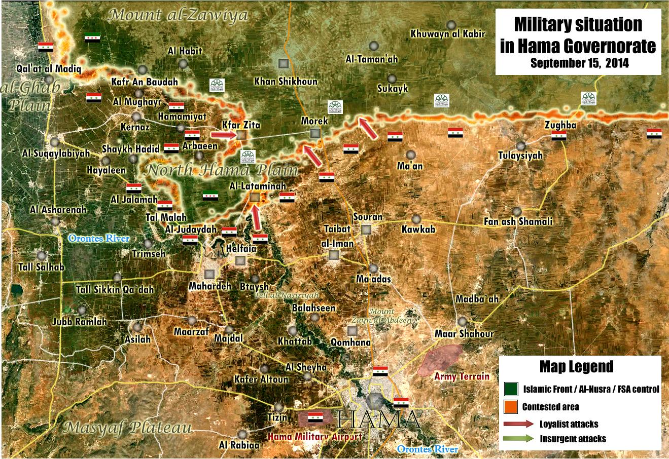
gov source: mork completely under rebel contro, SAA controls southern part of lataminah. no info on kfr zita. — Preceding unsigned comment added by 132.231.183.4 (talk) 07:21, 16 September 2014 (UTC)
Rural Hama map for updates
Peto Lucem Map is Anti Beheader map but quality is very good is always 95% right https://pbs.twimg.com/media/BxlnO9MCMAAvb57.jpg:large — Preceding unsigned comment added by 201.210.251.99 (talk) 20:00, 15 September 2014 (UTC)
- This is ture, Peto's maps are very high quality and accurate, but what are you suggesting. Should we put red rings around Latamenah and Kfar Zeta? 2602:30A:C01B:89F0:1910:8A37:B370:889B (talk) 21:31, 15 September 2014 (UTC)
It looks like the triangle (Latamenah, Kfar Zeta and Morek) are contested but I think we should wait for more sources Roy9955 (talk) 22:26, 15 September 2014 (UTC)
According to this map Jalma is under SAA control, not even contested. — Preceding unsigned comment added by 89.132.127.250 (talk) 09:36, 16 September 2014 (UTC)
Jayrud/Jayroud
- SOHR reports that the air force just bombed part of this town https://www.facebook.com/syriahroe/posts/583301061778236. I do not know of any source that reports a rebel presence in the town since April http://webcache.googleusercontent.com/search?q=cache:1WlVjya8mfMJ:www.middleeasteye.net/news/syria-raid-kills-civilians-while-businessman-announces-candidacy-president-1498124180+&cd=8&hl=en&ct=clnk&gl=us which I think was an asymmetric/hit-and-run attack. Nonetheless - I guess this is good reason to leave Khan abu Shammat and Brigade 559 up, because it seems that there is still some level of rebel activity in the eastern Qalamoun Boredwhytekid (talk) 14:01, 15 September 2014 (UTC)
- I agree with Boredwhytekid. Hanibal911 (talk) 14:54, 15 September 2014 (UTC)
SOHR reports clashes "near" Ain al Nuriyah https://www.facebook.com/syriahroe/posts/583302425111433. Most likely taking place amongst the army encampments between SAA held Ain al Nuriyah and rebel held Ufaniyah, seen here here. Just something to keep an eye on Boredwhytekid (talk) 15:04, 15 September 2014 (UTC)
Still clashes near Ain al Nuriyah https://www.facebook.com/syriahroe/posts/583661818408827 Boredwhytekid (talk) 12:29, 16 September 2014 (UTC)
And https://www.facebook.com/syriahroe/posts/583529065088769 Boredwhytekid (talk) 12:56, 16 September 2014 (UTC)
Flita, Qalamoun
SOHR still reporting clashes in the Qalamoun wastelands here. No need for adding additional green presence around Flita, because this action took place in the wilderness - I'm just posting this as an up-to-date justifier for the green circle to the northwest of Ras al Maara Boredwhytekid (talk) 15:00, 16 September 2014 (UTC)
- Here's more information about the situation in the area. Al Nusra Front fighters hit in ambushed the Syrian army in the Qalamoun border region of Flita, some 7 kilometers from the border with Lebanon, shortly before midnight and retreat to the border where they clashed with the Lebanese Army.The Daily Star Hanibal911 (talk) 15:18, 16 September 2014 (UTC)