
Talk:Control of cities during the Syrian civil war/Archive 58
| This is an archive of past discussions. Do not edit the contents of this page. If you wish to start a new discussion or revive an old one, please do so on the current talk page. |
| Archive 55 | Archive 56 | Archive 57 | Archive 58 | Archive 59 | Archive 60 | → | Archive 65 |
Battle of Salma + More North Latakia
SOHR reported the Army entered Salma, so did Al-Masdar. However, later latter reported the city has been captured by SAA. http://www.almasdarnews.com/article/breaking-syrian-army-liberates-the-strategic-town-of-salma-in-northeast-latakia/</ref>
- Has al Koum, next to Salma, been captured as well? I have seen no such reporting. MesmerMe (talk) 13:10, 12 January 2016 (UTC)
- Al Koum SAA-held.source Al Koum this one of the points from wher Army launched attack on Salma. Sûriyeya (talk) 13:13, 12 January 2016 (UTC)
- Kaom not taken by SAA. Your source mentions Kadin to the east. Kaom still in rebel hands. Source: http://www.almasdarnews.com/article/what-is-next-in-northern-latakia/ Oberschlesien1990 (talk) 09:55, 13 January 2016 (UTC)
Any news on Tartiyah ? 86.135.155.225 (talk) 14:20, 12 January 2016 (UTC)
Suriyeya thank you .86.135.155.225 (talk) 19:15, 12 January 2016 (UTC)
SOHR for now also claimed that whole town of Salma taken SAA.SOHR Sûriyeya (talk) 19:48, 12 January 2016 (UTC)
Oberschlesien1990 Al Koum taken SAA.source Sûriyeya (talk) 15:30, 13 January 2016 (UTC)
I think this belongs here under the Salma area too: Several More Villages are now SAA
January 16, 2016.
Addounia TV announed many villages, hills, and other areas to be Under SAA control. Villages on our map under SAA control as of today: Kendeesiyah, Sukariyah, and Jabel Kisbar (Kishkar) https://www.youtube.com/watch?v=Fy89WYvkuPI&feature=youtu.be. Also on our map under SAA control as of today: Jabel Zahi https://www.youtube.com/watch?v=Fy89WYvkuPI and Marj Khawkha https://www.youtube.com/watch?v=IhLJPAGJFkk&feature=youtu.be.
SDF-Arab-Kurd control
First i want you to read the previous discussion above. What I want is to open again a discussion, and ask the editors of why we shouldn't change back the way of editing the Raqqa province. My suggestion is to change the province as it was in August (i mean locations at that time), with minor changes with sources from today. There are basically several reasons, but by doing that we would remove 3 problems at the same time. The SDF will not represent a color, but the actuall groups inside. If a village is captured by YPG, we marked it as yellow, if a village is captured by both YPG and Arab groups (Shams Shamal batalion, Liwa Raqqa, Jaish Ahsaer, Jabhat Thuwar etc etc) we mark it as joint control. Problem solved. It doesn't matter if they're both part of the SDF, it's just a coalition.
- The whole reason why we began grouping units as part of the SDF coalition rather than individual groups is because the green designation for mainstream rebels is too broad. In Afrin we had the YPG fighting rebels meanwhile in Kobane and Jazira we had the YPG fighting alongside rebels. Hence the joint yellow-rebel control meant different things in different areas of the map - this was illogical. Hence we changed the villages of green-yellow control to yellow as both groups followed the administration of Syrian Democratic Assembly, whereas joint-control elsewhere generally means each party practice their own forms of governance.Prohibited Area (talk) 17:06, 7 January 2016 (UTC)
- DuckZz Prohibited Area I agree that the some villages for now under control the some of rebel groups which help YPG. But as say many sources their number not too big and therefore we can't mark as under jointly control YPG and rebels most part of the villages in Raqqa province which was retaken from ISIS. Many villages and some towns in Raqqa province which retaken from ISIS was taken SDF. But the SDF( ~40,000) it is a group where dominated by the YPG(30,000 fighters) and also smaller local Arab and Assyrian militias in northern Syria.source So that on based these data I propose again put the as rebels-held the villages(Zanbaq, Ali Bajliyah, Marouda Tahtani, Dughaniyah, Damishliyah, Wasita) and maybe some other in this area on based data from BosnoSinj.hereand here Plus as said this source FSA affiliate "Tribes’ Army (2,000 units) disbands in north amidst accusations of YPG blockade"here But I still trust that we can't leave all villages in Raqqa province as only under control of SDF(in the yellow color) some of them need put as the rebels-held. Sûriyeya (talk) 18:57, 7 January 2016 (UTC)
Sûriyeya Prohibited Area No you actually don't understand how this map works, it's like you started editing this map since last year ? We don't mark villages/towns as what will or is happening after they're being captured, because that would go too far and we would have to change the entire map once in a while based on who is currently present there (we actually do that for some areas), not just Raqqa but coming all the way from Idlib to Daraa. We mark areas as which group captured it like we did here. 60% of the villages in Raqqa province are empty, by your logic we need to remove them since nobody controls them since nobody has presence inside them, which is impossible and you need 120 000 active soldiers for that.
- You arguments are actually not arguments but POV opinions. We can also say "Well, some rebels have a truce with the gov. so lets remove their rebel presence because they're now again under civil rule" Makes sense, but not for this map. Rebels with the same flag clash with Kurds in Aleppo but not in Raqqa ? Erm.. so what, it's like you said "Rebels clash with Nusra in Idlib, but not in Damascus or Daraa province, let's mark them all under grey color". Rebels are rebels, it's not like they have 1 group and the same group is present in 2 provinces, with 2 different opinions, if that would be the case then yes we need to make a difference between them, but the groups in Raqqa will never be present in Aleppo, but both are claiming to be rebels and part of the armed opposition, which our map has a defition for. Changing that logic is actually violating the rules which you clearly don't understand. This is not your map and you have to understand that 80% of the people who look at this map think "Raqqa province is empty of rebels". Give me a good reason why I shouldn't remove the grey color from the map ? Al Nusra is part of the Jaish Fatah coalition, which consists of 70% of rebels, which means whatever Nusra captures, or only part of, i can mark it as under rebel control. Same logic.
- You have time till tomorrow to decide :
- 1 Keep the new current rule, but then implement it on the entire map and not just what u like, change the entire Idlib province to green.
- 2 Follow the rules of the map as it is, change Raqqa province as according to this map (with minor changes). DuckZz (talk) 21:57, 7 January 2016 (UTC)
- DuckZz, you are just a little bit too much focused on one belligerent. There are three other belligerents: ISIS, SAA, Islamists, all with different fractions, especially islamists and SAA, but we do not see you asking for making them green. Why not changing Ansari ISIS to green? or why not changing loyalist militas to green? Why just changing ethnic Arabs of SDF to green? The ones who are regarded by actual greens as traitors and agents of Assad? Why all this double standards?
- As with Idlib, I personally have come to the conclusion that it should be one color, as they represent only one belligerent. Either whole of Idlib green or grey. Roboskiye (talk) 22:26, 7 January 2016 (UTC)
Nothing what you say has to do with my text above. You post opinions, I post rules and arguments. I don't care what they are, what they think, I only care how to make this map understandable to normal people. And of course i won't change Idlib province, but I'm only being sarcastic because doing that would breake the rules, and using the double standard would make me only change that and nothing else, what is actually being donne for Raqqa province. So... yes, it's up to other editors to decide.
- I would also ask other editors to post on my talkpage because I think this section should be only for final desicions from other editors. DuckZz (talk) 23:04, 7 January 2016 (UTC)
- DuckZz Ok I agree with you that we need mark the villages in Raqqa province as you asked and as you said was earlier. But only with a small corrction Ayn Isaa under control YPG/YPJANHA(Hawar News)herehere and plus SOHR said that Tall Abyad under control by YPG.here And all new villages that had been captured recently also must be marked on yellow color because for now we know that the FSA affiliate "Tribes’ Army (2,000 units) disbands and sources said that the SDF captured all new villages. If you agree then we can fix the map and close the subject. Sûriyeya (talk) 07:58, 8 January 2016 (UTC)
- I would also ask other editors to post on my talkpage because I think this section should be only for final desicions from other editors. DuckZz (talk) 23:04, 7 January 2016 (UTC)
- Liwa Thuwwar al-Raqqa Raqqa Revolutionaries' Brigade (Al-Raqqah rebels){~ 1000 fighters} announced that they are joined to the SDF, after the tensions and information about the siege by SDF in the countryside of Al-Raqqah province, they said in the statement: “We in the Front Thowwar Al-Raqqah announce that we are part of the SDF, in order to fight the terrorism and extremism of ISIS and Al-Nusra Front.SOHR Sûriyeya (talk) 09:27, 8 January 2016 (UTC)
Sûriyeya Roboskiye My edits in Idlib province have been reverted because they breake the rules of editing. This means that north Raqqa province also breakes the rules, as we agreed that if you dont want double standard then a rule needs to me implemented on the entire map and not just POV areas. My edits south of Tell Abyad have been also reverted, 7 villages, with no source provided. I will change the Raqqa province as according to our map from August, where we have indicated which areas have been captured by both Kurdish and Arab forces. If you don't want this to happen, then implement the rules on the map, i will not do it because i dont want to revert someone elses reverts. DuckZz (talk) 20:37, 10 January 2016 (UTC)
- DuckZz I again put 7 villages as FSA-held according to the data from Bosnpoj and talk page. Sûriyeya (talk) 08:37, 11 January 2016 (UTC)
- FSA and their fanboys searching new adventures in Tell Abyad. FSA fanboys are angry and unhappy with northern Syria after 4 years of failed offensives and lost territories :) Bruskom talk to me 10:44, 11 January 2016 (UTC)
- Sûriyeya That map has been outdated by the disbandment of the Tribes' Army and Liwa al Raqqa joining SDF.Prohibited Area (talk) 17:35, 11 January 2016 (UTC)
- Prohibited Area If be honest for now I confused. Firstly we can't use any maps but we used data from Bosnoj (except map) But maybe we can leave these villages as under the jointly control. Although I've also seen report about disbandment of the Tribes' Army and Liwa al Raqqa joining SDF. So I'm confused. Perhaps you're right because I also saw another report which says that the former members of the Tribes' Army and Liwa al Raqqa joined the SDF. Liwa Thuwwar al-Raqqa Raqqa Revolutionaries' Brigade (Al-Raqqah rebels)announced that they are joined to the SDF, they said in the statement: “We in the Front Thowwar Al-Raqqah announce that we are part of the SDF, in order to fight the terrorism and extremism of ISIS and Al-Nusra Front.SOHR Sûriyeya (talk) 18:03, 11 January 2016 (UTC)
- SûriyeyaWell I would assume the villages should be changed back to yellow as we have no reliable source to show that they are under rebel control. The source which did show as such is now irrelevant, and the rebels joined SDF and hence we should change it to the respective colour, which is yellow, unless we can find sources which indicate otherwise.Prohibited Area (talk) 19:12, 11 January 2016 (UTC)
- Prohibited Area I still want hear the opinion of the DuckZz so how can he be able to provide other data confirming its point of view. Sûriyeya (talk) 19:31, 11 January 2016 (UTC)
- Prohibited Area But if we are dont get a new data which can provide that the after disbandment the Tribes' Army and after the Liwa al Raqqa joined to the SDF some the villages in Raqqa provicne still under control of the FSA-affiliated groups. We put these villages as under control of SDF. Sûriyeya (talk) 19:43, 11 January 2016 (UTC)
I am opposed to the changes.
The only forces who hold territory besides IS in Raqqah province is the SDF. The SDF should be marked in yellow, not green/yellow joint control, or some parts yellow and some parts green. This is because the SDF are a united military force, conducting operations and controlling territory together. Joint control should and must be reserved for situations where the non-SDF rebels share power with the SDF.
We mark the rebels in green because, although they fight one another, they are also (largely) united in their aim (to overthrow Assad). Although it would make things complicated, we could mark them under different branches like 'Islamic Front' and 'Free Syrian Army' to be more precise about these things, but these factions have largely coalesced into a single insurgent force. We mark IS in black because although it shares their locals aims, it has bigger goals, and is part of a global jihadist network. The same goes for al Nusra. The SDF only want to liberate parts of Syria to bring them under the control of the Syrian Democratic Assembly. All parties in the SDF work for the Syrian Democratic Assembly, and hence they are all marked in the same colour. The colour we mark them in should not be about ethnicity or militias: it should about military alliances, goals and global implications (such as whether they intend to gain territory outside of Syria or use it as an area from which to launch global terrorist attacks). PutItOnAMap (talk) 19:45, 11 January 2016 (UTC)
- The Twitter user called as bosnosinj just says that villages controlled by rebels. There is no news about this topic on Kurdish sources and international sources. I going to change back to yellow. Bruskom talk to me 20:58, 11 January 2016 (UTC)
Why would we base that on one twitter user? Are they a reliable source, and are they pro rebel or anti Kurd? Moreover, how would the rebels even gain control over that area? They have no access to those villages; they'd have to get through sdf and IS territory first to get there. Unless Liwa defected again, which we'd have heard about, then that would not happen.
- 1 The reporter "BosnjoSinj" is used for several years on this map for every party (Rebels/Gov etc. even ISIS), you maybe don't edit the map that long so you don't know, we had enough discussions about him and other users.
- 2 Liwa Thuwar Raqqa did join the SDF, but the area south of Tell Abyad (the user mentioned) is controled by "Jaish Ashaer" group, which isn't part of Thuwar Raqqa anymore (disolved by Thuwar Raqqa statement), one of the reasons is because Thuwar Raqqa joined the SDF, which means Jaish Ashaer is working alone and are still there of course. This is the facebook page of Jaish Ashaer and unfortunately, this is like the 3rd page and the previous one got deleted but i remember their statements there, where they mentioned their control, and its basically the same as BosnjoSinj reported.
- 3 I did not wanted to make these edits, why ? Very simple, it's against the rules. Now you think, well why ? Again, leaving the area as it is now is also agains the rules, basically leaving these edits, or removing them is both against the rules. Why ?
- The new "SDF" rule is explained last year, and it was explained very badly and i have read it, according to them, the rule needs to be implemented in Idlib province on various villages and towns. Why ? Because those towns are captured by Jaish Fatah, but they're marked as "grey", even thought Nusra makes only 20% of the coalition or fighting force itself, basically the same as Rebels in Raqqa province.
- Now if you want to leave the SDF color in Raqqa, you also need to implement the rule on other provinces, and i don't care for POV views like "Well Kurds are not islamists like rebels are here and there, unlike in Raqqa blablabla" whatever you say contradicts with our map and makes it a useless twitter discussion piece.
- We also broke another rule, here's why. Remember the "Burkan Firat" coalition from last year ? That's basically the same as todays SDF, same principle and ideology, where Kurds again made 70% of the fighting force. The only difference is the amount of groups, where SDF has like 20, but the percentenge is the same. Now I ask you, why did we edit the Raqqa province for 6 months, according to rules, and the finnal version was like this. And now you tell me, "Ok, now the SDF is created, it's the same as Burkan Firat but with a bunch of other groups from Hasaka too, we now change a rule but breake 2 others instead.".
- I know why you did this, and it did make sense at the start, because the main problem was Hasaka province, where YPG with 400 soldiers captured a village, and rebels had like 10 members, we marked the village as under joint control which was stupid because those rebels aren't even from Hasaka and they will return to Raqqa. I do agree, Hasaka is a good option, but Raqqa isn't, and the map from August shows that.
- 4 Again, if you hate and don't want discussions, I will change the province as according to our map from August, of course we need to change some areas but that will be donne in 1-2 days, that's only if you want rules, and don't worry, I will read every source.
- 5 And For those asking "I maybe agree but how much rebels are there actually in Raqqa ?", it's pretty simple, more than double since Burkan Firat, and if we didn't had problems then, why should we know ? Liwa Thuwar Raqqa had enough statements where they said that they have >3 000 soldiers, and every week some finnish their new training. Jaish Ashar stated >2 000 for them. Jaish thuwar stated 1 000 for them, Kataib Shams Shamal 300-500 since Kobane, and there's also Furat Jarabulus etc.
1. Burkan Firat was an operations room (like the Mare' operations room), not a Syria-wide coalition. All groups in the SDF are allied throughout Syria. Jaish al-Thuwar, for instance, is allied to the SDF in Aleppo, Idlib and Raqqa, as well as any other provinces they might expand into. Whereas Burkan Firat only applied in a specific area to defend against IS. Moreover, Burkan Firat contained groups with different 'endgame' aims: the SDF is united under the political organisation called the 'Syrian Democratic Assembly', which decides what its objectives will be.
2. Fair enough about BosnjoSinj. I do find it odd that no-one else is reporting on Jaish Ashaer's control of these villages, though. In fact, http://syriadirect.org/news/ahead-of-battle-against-islamic-state-in-syria’s-northeast-one-faction-hesitates-to-join-sdf/</ref> this source says that Jaish Ashaer was the Tribes' Army, not a component of it. Therefore, according to this source, it must have disbanded.
3. If rules were broken in the past, or old rules applied then that do not apply now, it is now wrong for us to contradict out of date rules.
4. Liwa was estimated at 800+ troops by US resources, but however many troops they have is irrelevant to this map. They are SDF, anyway.
5. We don't need to revert the map to August. Just keep SDF yellow and everything will be fine.
6. I do not support marking joint-held Jabhat al-Nusra areas grey because they are salafist. The reason they should be grey is because they have international ambitions. The way I understood it, we grouped the armed forces like colours into distinct sects:
(1) The SAA and allies, which wants to reimpose Assad's control over Syria. (2) The SDF, which is hostile to the regime and jihadists, but focuses on controlling and running areas of Syria that the Syrian Democratic Assembly wants to take responsibility for. (3) IS, which wants to establish a global caliphate, and is just using Syria as a (particularly important) base of operations now. (4) Al Nusra, which wants the same thing as IS, but it part of the Al Qaeda network. It has a different colour to the likes of Ahrar ash-Sham because it wants to go international (hence its attack on Arsal), while the other Islamists are focused, along with the rest of the rebels, on fighting only in Syria to topple the regime, for now. (5) The rebels, focused on toppling the Assad regime.
PutItOnAMap (talk) 21:42, 11 January 2016 (UTC)
- PutItOnAMapProhibited AreaDuckZzBruskom Shuhada' al-Furat Battalion(Euphrates Martyrs Battalion) announce in a statement issued that they join to Syria Democratic Forces.herehere So that as we can see the another one a rebel group join to SDF(mainly kurdish force). Video:here Sûriyeya (talk) 18:07, 13 January 2016 (UTC)
Semi-protected edit request on 13 January 2016
This edit request to Module:Syrian Civil War detailed map has been answered. Set the |answered= or |ans= parameter to no to reactivate your request. |
Hello, I was in the editing team since the beginning of the Syrian war. I left it because of work. Now I would like to participate again in the editing. I was never blocked for violating editing rules, and I am aware of all the editing rules here. I am also following your updates in the talk page about the accepted and biased reference sources and I like that.
Please accept my edit request. Thanks, 91.43.150.169 (talk) 23:36, 13 January 2016 (UTC)
 Not done: it's not clear what changes you want to be made. Please mention the specific changes in a "change X to Y" format. Datbubblegumdoe[talk – contribs] 03:27, 22 January 2016 (UTC)
SAA captures Tal Farzat north of Marj Sultan
SAA captures Tal Farzat http://wikimapia.org/#lang=ro&lat=33.506387&lon=36.472614&z=16&m=b&show=/25987421/Tell-Ferzat north of Marj Sultan. Source: http://www.almasdarnews.com/article/syrian-army-seizes-tal-farzat-in-rural-damascus/ Ariskar (talk) 09:43, 12 January 2016 (UTC)
Correct, they captured that along with AlBilaiyah two days ago to the east of it. I didn't know however how this page looks at Almasdar news. Also, it is difficult to wait for insurgents to declare losses — Preceding unsigned comment added by 67.181.121.82 (talk) 01:52, 14 January 2016 (UTC)
Ghazal
Opp. sources Aleppo24 and Qasioun News reported that the ISIS retake village of Ghazal from rebels north of Aleppo.herehere and SOHR confirmed that ISIS retake this village.here Sûriyeya (talk) 11:49, 14 January 2016 (UTC)
SOHR report ?
Has SOHR reported the taking of Aran south of Al Bab by the reds ?.Twitter sources are saying so but i can not find it .86.178.96.33 (talk) 12:32, 14 January 2016 (UTC)
- The village of Aran here for now marked as SAA-held.here Sûriyeya (talk) 12:48, 14 January 2016 (UTC)
Well, I haven't seen it, but it may be up in the Arabic version. Also, I apologise for marking Ain Issa as contested earlier. The English report said 'in the west of' and I thought that meant within the town, not to the west of it. If another reliable source (although not a pro-SAA one in this case) is reporting Aran as taken by the SAA, we should mark it as red rather than waiting for SOHR confirmation. PutItOnAMap (talk) 14:11, 14 January 2016 (UTC)
- PutItOnAMap Sometimes in reports from SOHR English have some mistakes. But in the title of the article reads "clashes near Ayn Issa in Al-Raqqah" But in report on Arabic SOHR said "clashes between units protect the Kurdish people from the party, and elements of the "Islamic state" from another party, in the western countryside to the town of Ain Issa in North West countryside of Raqqa"here Sûriyeya (talk) 15:01, 14 January 2016 (UTC)
SAA Hama Offensive
SOHR confirmed that the SAA captured the village of Deir al-Fardis.here this also confirmed opp. source.here Sûriyeya (talk) 18:07, 14 January 2016 (UTC)
Aran
Pro-opp. source Aleppo24 reported that the SAA captured the village of Aran to south of ISIS-held town Tadef.here Sûriyeya (talk) 10:49, 14 January 2016 (UTC)
- SOHR also said that the SAA captured the village of Aran.here Sûriyeya (talk) 11:20, 14 January 2016 (UTC)
- SAA captured 4 villages Surayb, Ajouziyah, ‘Abboudiyah, and Miltafah.SOHRsourceSOHR but retreated from Aran after ISIS counter-attack.SOHR Sûriyeya (talk) 18:05, 14 January 2016 (UTC)
SOHR and all pro gov sources say Aran has been taken by SAA. But then only SOHR says the SAA left Aran! — Preceding unsigned comment added by 76.125.37.45 (talk) 01:05, 15 January 2016 (UTC)
Remove all city detail maps!
Remove all city detail maps , leaving only a mouse-link to them. My suggestion for the detail maps for various syrian cities is to remove them all from main map , replace them with our ususal cake charts (circles) . Each suborb can have its own dot. (for example, Alleppo as as cake with some green and red and yellow sections, Damascus as (contested ?) green and red, Duma as as a green dot, ...) ( like Iraqi map) and if someone clicks on them, he can see the actual detailed map with its late date. This solution make the entire map system (Iraq, Yeman, ...) consistent and uniform because syrian map is the only template with these disturbing detail maps. If you accept to do this, I will draw the roads in the background map in the gaps which remain from removed detail maps as soon as I can. 212.75.52.4 (talk) 09:10, 12 January 2016 (UTC)MapMaker
- I'm not sure if we should remove all, because some like Aleppo map are more complicated and in my opinion better to stay as images. However, the Hasaka map should definitely be removed as over 90% of the city is under SDF control. The loyalists control merely two districts: City center and Ghuweyran. Furthermore, there is an important mistake in the map: Why MSF controlled area is blue? MSF is an YPG offshoot and is part of SDF. It should definitely go yellow. So to conclude: a big yellow dot for entire Hasaka, + two small dots for the aforementioned loyalist-controlled districts. Roboskiye (talk) 09:25, 12 January 2016 (UTC)
- Roboskiye Which source provide this? SDF not control over 90% of Hasakah. We now that they hold most part of him but not over 90% of city. Also in blue color marked areas in Qamishli which the under jointly control Syrian armySootoro/ and YPG/Sutoro. Sûriyeya (talk) 13:17, 12 January 2016 (UTC)
The detailed maps for Hasakah and Qamishli add nothing of value but the other 4 all do. Damascus and Aleppo in particularly would just be an utter mess if every suburb had to be represented by a separate dot. It might be worth cropping the maps to remove the countryside and neighbouring towns but for the core urban areas the detailed maps should stay. 77.101.181.174 (talk) 14:38, 12 January 2016 (UTC)
- I strongly oppose the deletion of the detailed Syrian city maps. Contrary to what some say here, they are much more useful than a "dot", and if we remove them I bet that we will have big dots full of tiny dots, military bases, etc, sometimes simply unreadable (take for example Taizz in the Yemen map, wich has inside military bases icons wich are barely visible, clear example of a mess). It will also give the authors the message that their efforts and work were good for nothing. I suggest editors try to update the maps instead of trying to ruin others work.--HCPUNXKID 00:01, 13 January 2016 (UTC)
- The detailed maps are incredibly important to the template, even the Hasakah and Qamishli maps give a much more detailed insight into the conditions of the war and hence should most definetly be kept. The only problem is when the maps become outdated, as most editors (including myself) do not know how to edit them.Prohibited Area (talk) 14:34, 13 January 2016 (UTC)
I think even the Hasakah and Qamlishi maps are quite important, at least from a military perspective (as seeing who controls what is significant to those studying the Syrian conflict). For instance, if we just made Qamlishi a big yellow dot with a few red marks, knowledge of the fact that the SAA control certain roads, the border post and - crucially - the airport would be less clear to readers. Moreover, the argument that because there is no conflict in those areas, we should remove the maps is flawed because of a number of clashes (small-scale but notable) in those areas. It is possible that in the future (especially with the increasing number of anti-SAA groups joining the SDF) clashes may break out again in these areas as part of a possible SDF offensive once they have achieved their objectives against IS west of the Euphrates and in Hasakah province. We should not speculate too much and say 'x will happen' but it is wise to be prepared for any possibility in an unpredictable conflict like this one. Therefore, I oppose the removal of the detailed maps, even the Hasakah and Qamlishi ones. We may even want to consider adding new detailed maps (if that is possible/if we have the editing skills) in other big, contested places such as Shaykh Miksin). PutItOnAMap (talk) 11:04, 14 January 2016 (UTC)
- The Question of maintaining and actuality is more important than details in these areas( which will be visible as before if you click on the dot) . Actually no one feels himself responsible to update these detailed maps!. But there are many people who keep the dots uptodate very close to reality.
- + To avoid a mess in dots, I suggest to use a big 'ring'( empty dot, only with borders of one or two pixels thickness) instead of a dot, for large cities. In this ring, we will be able to see the smaller dots. We can even also use this rings everywhere instead of dots! ----212.75.52.4 (talk) 14:55, 15 January 2016 (UTC)MapMaker
Please change "Al Hawr" الحَور and "Al Kum" الکوم and "Marj Khawkha" مرج خوخه to red.
All Salma neighbors under SAA
Al-Hawr under SAA
212.75.52.4 (talk) 13:06, 13 January 2016 (UTC)MapMaker
- We cant use a maps as a source. "Rules for editing the map" Rule #2 Copying from maps is strictly prohibited. Sûriyeya (talk) 14:52, 13 January 2016 (UTC)
- I made this. Reliable source confirmed that the Al-Koum, Al-Mareeij, Marj Khawkhah, Bayt Miru, Al-Hawr and Mrouniyat taken SAA.here Sûriyeya (talk) 15:20, 13 January 2016 (UTC)
- Maps from this source are very very reliable http://newss.blog.ir/ ----212.75.52.4 (talk) 16:19, 13 January 2016 (UTC)MapMaker
Today reds take Duwayrikah per AL Masdar .86.178.96.33 (talk) 19:33, 15 January 2016 (UTC)
SAA take Al-Faradis
[1] According to SOHR, the SAA has taken Al-Faradis village. I would put this on the map, but I don't know what exactly its coordinates would be (which villages in Hama is it closest to?) PutItOnAMap (talk) 09:38, 15 January 2016 (UTC)
- PutItOnAMap it is a village of Dayr al-Fardis which is taken SAA. Sûriyeya (talk) 10:28, 15 January 2016 (UTC)
Ok. That's already marked red on our map anyway. PutItOnAMap (talk) 10:33, 15 January 2016 (UTC)
Harbnafsah
SAA Captured the town. Source: http://www.almasdarnews.com/article/syrian-army-captures-the-village-of-harbnafsah-in-northern-homs/ MesmerMe (talk) 22:34, 13 January 2016 (UTC)
According to all other sources it is contested .86.178.103.141 (talk) 19:59, 16 January 2016 (UTC)
Please use a darker Yellow for Kurds!
This yellow is hardly distinguishable. Please take a darker yellow or darker Orange-Yellow!( the same in detail maps of Al Hasahak, for example) ----212.75.52.4 (talk) 15:25, 15 January 2016 (UTC)MapMaker
- We always used the yellow color since the start of Syrian civil war. The whole world knows that the yellow color represent the Kurds. Also orange color does not represent the Kurds. Bruskom talk to me 08:11, 17 January 2016 (UTC)
- I didn't say orange, but darker yellow or this darker orange-yellow which is already used in detail city maps like Hasaka to mark kurdish areas. 2003:6A:675C:A6F3:AD0A:DFD2:8119:9616 (talk) 10:06, 17 January 2016 (UTC)MapMaker
Damascus detailed map
Damascus detailed map is not updated and lags behind the most recent news. See Talk. Either the editor able to change it takes some action or we must do about it like we did for Aleppo map.Paolowalter (talk) 10:15, 10 January 2016 (UTC)
The editor knew that there were massive changes to be made and left the map like it has been for nearly a year even though it has been edited Eastern Ghouta is 60% smaller of what is currently shown in terrorists control. Darryya is also waay smaller pocket now tiny. Jober is in SAA control and is now totally seperate from east ghouta.
The City maps are not updated for weeks and should be replaced with something better .86.135.155.225 (talk) 18:46, 10 January 2016 (UTC)
The battle lines in Deir Ezzor have also shifted somewhat and that city map needs to be updated, too. Several distracts including Sina'a (if that's a correct spelling; I know there are several) and Jafra are now under IS control. Also, Aleppo is changing all the time. The problem we have there is that when we removed Kweires from the map, we didn't reapply the old map with the roads and textures in the background that is there in the rest of the map, so there is just a blank space in the Kweires area, which we should fix. The regime only controls 20% of Qamishli, but it looks like more than that on our map. The Hasakah map should have the blue bit removed from it, and both the YPG and the Syriac Military Council are both part of the SDF now and should be marked in its colour rather than the colours of their individual militias. I also read complaints earlier on this page that the Daraa map appears to exaggerate the rebel presence, though I am not sure of whether or not this is true. PutItOnAMap (talk) 22:21, 10 January 2016 (UTC)
- PutItOnAMap If you see on a map the village of Jafra marked as the ISIS held. on the map most part of the city Qamishli marked as YPG-held the some part of SAA-held and in blue color we marked the part of the city which is under jointly control between SAA and YPG. Sûriyeya (talk) 09:38, 11 January 2016 (UTC)
Qamishli map is basically irrelevant, the various sides are controling jointly the town. Paolowalter (talk) 18:24, 11 January 2016 (UTC)
- Also anti-SAA source said that the clashes took place in the town of Jafrah in the surroundings of Deir Ezzor Military Airport.source Sûriyeya (talk) 11:29, 11 January 2016 (UTC)
- Sûriyeya this source is an Anti-Isis source to,it's a pro-rebel source we need reliable sources.Lists129 (talk) 13:12, 11 January 2016 (UTC)
- It is anti ISIS and anti SAA, so it is fine according to the rules to change the map following it. In any case Jafrah was turned black based on vague statements that was attacking from the town, nobody stated that they took full control of the town. So, it goes contestedPaolowalter (talk) 18:24, 11 January 2016 (UTC)
- Lists129 Both of these a sources clear anti-SAA sources which sometimes publish data about which claim ISIS but which not was confirmed the reliable sources including SOHR. For now these sources said that the clashes took place in the town of Jafrah in the surroundings of Deir Ezzor Military Airport.sourcesource Sûriyeya (talk) 18:38, 11 January 2016 (UTC)
"The problem we have there is that when we removed Kweires from the map, we didn't reapply the old map with the roads and textures in the background that is there in the rest of the map, so there is just a blank space in the Kweires area, which we should fix." Can somebody fix that ? Because it's really ugly now when you look at the map. 85.218.59.241 (talk) 21:01, 11 January 2016 (UTC)
Editor (e.g. Sûriyeya) is adding dots on detailed maps that is not what we are supposed to do. Either we get them updated, or we remove them. We cannot have the same location marked with two different colors on detailed and general maps.Paolowalter (talk) 22:28, 11 January 2016 (UTC)
The Damascus map needs to be cropped a little from its west so it doesn't include Khan Al Sheikh green area on its southwest, or Wadi Barada on the northwest corner. These parts are far enough from damascus that they are behind mountains and army bases surrounding the city, the two areas can be replaced with a few dots on the main map. Especially khan al Sheikh area where red dots of the main map appear on top of the green area of the detailed map! This really needs fixing.
I think that only Damas and Aleppo are useful. Others can be deleted. Plus Damas detailed map should be smaller. 85.218.59.241 (talk) 15:33, 12 January 2016 (UTC)
Yes Agree with above regarding the Damascus map to be made smaller, I'm sure editors see that is a good idea, I hope it gets edited soon. Dair Al-Zor and Dara'a detailed maps should still be useful.
All currently contested major cities (regional capitals plus Qamlishi at the moment; I don't think any other massive hubs are contested right now) should have detailed maps.
As I have written in 'Remove All City Detail Maps!':
[I think even the Hasakah and Qamlishi maps are quite important, at least from a military perspective (as seeing who controls what is significant to those studying the Syrian conflict). For instance, if we just made Qamlishi a big yellow dot with a few red marks, knowledge of the fact that the SAA control certain roads, the border post and - crucially - the airport would be less clear to readers. Moreover, the argument that because there is no conflict in those areas, we should remove the maps is flawed because of a number of clashes (small-scale but notable) in those areas. It is possible that in the future (especially with the increasing number of anti-SAA groups joining the SDF) clashes may break out again in these areas as part of a possible SDF offensive once they have achieved their objectives against IS west of the Euphrates and in Hasakah province. We should not speculate too much and say 'x will happen' but it is wise to be prepared for any possibility in an unpredictable conflict like this one. Therefore, I oppose the removal of the detailed maps, even the Hasakah and Qamlishi ones. We may even want to consider adding new detailed maps (if that is possible/if we have the editing skills) in other big, contested places such as Shaykh Miksin).] — Preceding unsigned comment added by PutItOnAMap (talk • contribs) 23:46, 14 January 2016 (UTC)
Editors, will you take an hour of your time to crop the damas detailed map and update it please. Everyone seems to be frustrated w it. We thank you in advance. — Preceding unsigned comment added by 76.125.37.45 (talk) 11:42, 17 January 2016 (UTC)
New Map Aleppo Gap Roads Fixed!
Here the new map : Roads of Aleppo Province fixed ----212.75.52.4 (talk) 14:39, 15 January 2016 (UTC)MapMaker
Good work .86.178.103.141 (talk) 20:24, 16 January 2016 (UTC)
- Although I made the roads of the Aleppo-map-gap, the right side of the (cropped) map is not transparent, thus, we can not see the roades there ( Kuwairas, power plant, etc.) ----212.75.52.4 (talk) 08:35, 18 January 2016 (UTC)MapMaker
Deir Ezzor
My first problem here. I think the EE semicircle icon on Shulah village should be removed. The location of the village is here, and the closest gov. positions are probably here, and there's nothing in between. And that location is not even marked on our map. There's an oilfield east of Shulah village, and this semicircle indicated that gov. controls it, but they don't as it's too close to the village. DuckZz (talk) 22:03, 17 January 2016 (UTC)
- DuckZz Which source mantion that the the closest gov. positions are probably here You not provide any reliable sources but you edit a map but this was unjustified step as it is just your assumption. Or maybe you have a relaible source (but not map) which is can acquit your edit. Sûriyeya (talk) 12:12, 18 January 2016 (UTC)
Because according to our semicircle, the gov. forces are right next to Shulah village, which would indicate they control this oilfield, which they don't because they never claimed that. Because of that, you have 2 options :
- 1 Remove the semicircle
- 2 Add the oilfield as IS held, and then add the semircle again but on the oilfield, not the village itself.DuckZz (talk) 12:18, 18 January 2016 (UTC)
- DuckZz So in this situatuon we must add this oil field and put semicircle near of him but not just remove semicircle. I only want explane you that I not going to deny a these your actions completely I just want a more accurately show this situation on map. Or maybe find another solution. Maybe put this icon
 in this area here. Nevertheless, we do not have data from a reliable source that in this area the closest army positions. Sûriyeya (talk) 12:56, 18 January 2016 (UTC)
Yes I agree, remove the semicircle and put the rural presence icon. DuckZz (talk) 13:31, 18 January 2016 (UTC)
- DuckZz Wery good as we find the best comoromissed solution. So I ask uou do this. Because for now I will offline and I'm will go back only a few hours later. Sûriyeya (talk) 13:59, 18 January 2016 (UTC)
My main problem with Deir Ezzor is the fact that we are only marking the neighbourhoods with the icons of towns, when we should be updating the colouring of the city map according to control. Can anyone get hold of the users who edit these maps, so they can updaet them? According to SOHR, Deir Ezzor is 60% under IS control now, but the map tells a completely different story. We have a similar problem in southwest Aleppo city, where the regime presence is not properly represented. The territory around many of the strategic poitns it holds in the city, such as Al Khalidiyah, is marked in green, but it should be red (otherwise, the SAA would not have been able to get to those areas in the first place). PutItOnAMap (talk) 16:38, 18 January 2016 (UTC)
Reliable and biased sources
I ask all editors not use for edit as a reliable sources: 1) Unknow and biased sources from Twitter and Facebook. This also indicated in the editing rules.
- Rule#1 - 1- A reliable source for that specific edit should be provided.
a) A well-known source that has a reputation for neutral (not biased) territorial control coverage, can be used (is deemed reliable) for all edits.
b) A well-known source that does not have a reputation for neutral (not biased) territorial control coverage, can be used (is deemed reliable) only for edits that are unfavorable to the side it prefers (favorable to the side it opposes).
c) A source that is not well-known (or that has proven inaccurate for all edits) cannot be used (is deemed unreliable) for any edit. This includes all maps (see item 2- next).
Also not use sources which is clear opposes one of sides in Syrian War. Not use Russian, Iranian against rebels and ISIS as this countrty support Syrian government in their fight against rebels and ISIS. Also not use against Syrian troops all Tourkish sources because Turkey is clear opposes SAA and support forces which fight against SAA. Also for now Russian/Iranian troops help SAA but Turkish troops helps the rebels and some times help ISIS. And guys let's less use data from social sources as Facebook and Twitter. Let's we will not provoke chaos. Sûriyeya (talk) 17:50, 18 January 2016 (UTC)
We agree that the reliable pro-opp. SOHR, reliable pro-SAA Al Masdar and reliable pro-YPG Hawar News we use as a reliable sources for show success for all sides and more should be no exceptions. Sûriyeya (talk) 17:50, 18 January 2016 (UTC)
- Sûriyeya the only 2 reliable sources to edit this template that were deemed and agreed reliable by Tradedia are SOHR and Al-Masdar.Lists129 (talk) 18:13, 18 January 2016 (UTC)
- Lists129 I thought that the Hawar News also was recognized as as a relaible source because I saw that it was used by many editors as a reliable. But if I'm wrong then I apologize. Sûriyeya (talk) 18:19, 18 January 2016 (UTC)
- Sûriyeya no need to apologize for anything,I only was explaining which sources are reliable to edit according to what was agreed on and that this source is not part of it,you can look in the archives or just ask Tradedia about this case.Lists129 (talk) 18:38, 18 January 2016 (UTC)
Eastren Hama
Can someone provide me the sources or the diff that used to change these villages status: Al-Qatshyeh,Dukaylah,Qalib al Thawr,Abu Hubaylat,Makfar al Shaqri.I can't find them?? Lists129 (talk) 16:41, 18 January 2016 (UTC)
- Lists129 According to SOHR. I can provide link soon. Sûriyeya (talk) 17:12, 18 January 2016 (UTC)
- Sûriyeya diff?Lists129 (talk) 17:17, 18 January 2016 (UTC)
- Lists129 Source for villages the Abu Hubaylat, Dukaylah, Qalib al Thawr.here SAA advance and clashes in these villages between SAA and ISIS. Sûriyeya (talk) 17:19, 18 January 2016 (UTC)
- Sûriyeya I cant understand arabic so I needed to translate it, but it didn't translate it the best way possible but it mention something about clashes :/.Lists129 (talk) 18:02, 18 January 2016 (UTC)
- Lists129 violent clashes continue in hand Uqayribat area eastern of Hama concentrated in Dukaylah, Qalib al Thawr and Abu Habaylat, between ISIS and the regime forces and allies, following an attack carried out by the SAA in this region, with support the bombing of military aircrafts likely the Russian in the Uqayribat area. Sûriyeya (talk) 18:14, 18 January 2016 (UTC)
- Sûriyeya clashes inside or in the outskirts of this villages.Lists129 (talk) 18:40, 18 January 2016 (UTC)
- Sûriyeya thank you.Lists129 (talk) 19:34, 18 January 2016 (UTC)
ISIL Deir Ezzour Offensive
[[2]] Anti-ISIS source reports that ISIS are in control of Ayyash, and the arms depots and Bughayliyah. Please update the map91.85.60.235 (talk) 18:50, 18 January 2016 (UTC)
- Reliable sources including SOHR confirmed that the town of Ayyash taken ISIS. But SOHR and other reliable source clear said that clashes still continued in Bughayliyah and inside Ayyash army depots.herehereherehereherehere Sûriyeya (talk) 18:57, 18 January 2016 (UTC)
- I think we can add Sa'iqah army base in the map and change the Ayash arms depots status.Lists129 (talk) 19:44, 18 January 2016 (UTC)
- Sûriyeya the source above that the ip provided,also it's logical that this camp/base has fallen and is Isis held beacause it's situated north of Ayash army depots were clashes are taking place.Lists129 (talk) 20:37, 18 January 2016 (UTC)
- Lists129 Probably you are right. Sûriyeya (talk) 20:38, 18 January 2016 (UTC)
- Sûriyeya Location [3].Lists129 (talk) 20:42, 18 January 2016 (UTC)
Aleppo city map
Can anyone fix the blank space left on the right side to the map? --HCPUNXKID 00:04, 13 January 2016 (UTC)
- As the frontline goes into these areas, I think its better we cropp the Aleppo detail map instead of covering it by white image. we lost the roads in this area. 85.15.42.246 (talk) 06:08, 13 January 2016 (UTC)
The frontline is also getting more and more different any time in the Western border of Aleppo as the SAA is currently pushing towards Al-Rashiddeen district. So in this case the entire west-east frontie can be blanked.Oroszka (talk) 16:56, 13 January 2016 (UTC)
I will fix the roads, etc. in blanc space Allepo as soon as possible----212.75.52.4 (talk) 08:15, 15 January 2016 (UTC)MapMaker
Azaz Checkpoint
Azaz checkpoint captured by SDF: http://hawarnews.com/%D8%AC%D9%8A%D8%B4-%D8%A7%D9%84%D8%AB%D9%88%D8%A7%D8%B1-%D9%8A%D8%AD%D8%B1%D8%B1-%D8%AB%D9%84%D8%A7%D8%AB%D8%A9-%D9%86%D9%82%D8%A7%D8%B7-%D9%87%D8%A7%D9%85%D8%A9-%D9%85%D9%86-%D8%A7%D9%84%D9%85%D8%B1/ Roboskiye (talk) 10:17, 17 January 2016 (UTC)
- Roboskiye Probably here Sûriyeya (talk) 16:59, 17 January 2016 (UTC)
I think I read somewhere that we do not use Hawar news for SDF advances and successes. That said, we should be vigiliant in case this news pops up somewhere else. If we find that the SDF is beseiging Azaz at some point from the southwest, it's probably safe to assume that they took the checkpoint marked on our map after all. PutItOnAMap (talk) 16:15, 19 January 2016 (UTC)
Shaer and Jazl
[4] This is the second time in a matter of days that an attack on Shaer and Jazl is reported. Would siege signs for Shaer and Jazl be appropriate to use in this case? It does not specifically mention a siege, but repeated attacks carried out in quick succession could among to that. PutItOnAMap (talk) 13:30, 19 January 2016 (UTC)
- PutItOnAMap We put black semicirkle near Shaer gas fields because reliable source said that the ISIS start the offensive toward Shaer gas fields and that this SAA repell this attack but ISIS entrenched to north of these gas fields. But ISIS not launch offensice to grab Jazal oil fields. ISIS only attacked the army positions in area of the Shaer and Jazl oilfields in the eastern countryside of Homs.here Also maybe this was hit and run or cporadic clashes. If we put semicircle awerytime when SOHR said about attack then we have semicircle near many villages or towns. SOHR not said that the ISIS try captured Jazal oil fields or that they capturd some of army positions near Jazal oil fields. Sûriyeya (talk) 15:27, 19 January 2016 (UTC)
- PutItOnAMap In original report SOHR said that the ISIS just shelled army positions near Shaer and Jazal oilfields.here Sûriyeya (talk) 15:42, 19 January 2016 (UTC)
Okay, thanks for the information. I'll keep that in mind in the future. I was assuming that when SOHR mentioned Jazl, it meant the town rather than the oilfields, the latter of which would be considerably harder to attack without having positions in the former. PutItOnAMap (talk) 15:51, 19 January 2016 (UTC)
- PutItOnAMap Reliable source said that the Earlier today, SAA in coordination with NDF were able to repel the ISIS attack on the Al-Sha’ar Gas Fields, forcing them to withdraw towards the small village of Al-Bayarat in Palmyra’s (Tadmur) western countryside and later SAA reentering to the villages of Al-Bayarat and Al Dawa. Currently, clashes between SAA and ISIS on distane of 2 km outside of the ancient city of Palmyra.here Sûriyeya (talk) 19:09, 19 January 2016 (UTC)
South Damascus
According to AlMasdar the area south of Damascus including Yarmouk camp and Hajar al Haswar is going on truce. The Damascus map should be updated but I know it also impossible to have it updated.Paolowalter (talk) 23:30, 19 January 2016 (UTC)
Turkmen/Opposition Offensive - January
Turkmen/Opposition Offensive in Latakia and towards Jarablus with Turkish-American Support
Starting last week with YPG's advance in Tishrin area, Turkey has been targetting DAESH targets with artilleries and shellings, also Turkish and American coalition jets have been striking DAESH targets in this area while (moderate) opposition groups, dominantly Syrian Turkmen Brigades, namely, Sultan Murat Brigade, Fatih Sultan Mehmet Brigade and Muntasır Billah Brigade advance towards Jarablus along the Turkey-Syria border, making gains against DAESH and engaging in war in some locations.
Additionally, Syrian Turkmen Brigades in Latakia's Bayırbucak Turkmen area, namely, II. Sahil Brigade and Turkmen Mountain Brigade have made some gains against Assad forces and are engaging in war in some locations.
Turkmen-Opposition (moderate opposition groups) sources and Turkish newspapers published several news about the gains. I'm gathering those here and will do the changes in the map afterwards.
Azaz-Jarablus Line:
Gains (against ISIS); Harabah, Nefse, Baghaydin, Kızılmezra, Karamezra, Karaköprü, Hurbe (with Turkish Armed Forces and American jets support)
Sieges (against ISIS); Düden, Tuklu, Mırğıl, Kefra, Hırbil, Çoğanbey (with Turkish Armed Forces and American jets support)
Interior Aleppo Province and city of Aleppo:
Gains(against Assad); Başköy
Sieges(against PYD); Malikiyah, Meranaz
Bayırbucak (Northern Latakia):
Gains(against Assad); Mrouniyat, Dağdağan(Al Nusra left the positions with an agreement)
Sieges(against Assad); Kızıldağ, Ğımam
Sources: (11/12 dated last 2 weeks)
News Sources;
- Hürriyet - Gains and Sieges on Azaz-Jarablus line with Turkish support
- Akşam - Offensive in Azaz-Jarablus line
- Prior gains of Harjalah and Delha by Turkmen with Turkish-American support
- Haber3 - Gains of Karamezra, Karaköprü and Harabah, attack to Tuklu and Düden
- Hürriyet - 4 villages taken from DAESH, Syrian Turkmen Assembly will be officially represented in Peace Talks among Opposition
Turkmen/Opposition Sources;
- Syrian Turkmen Assembly - Official Statement on Advance in Bayırbucak/Northern Latakia
- Advances in Central Aleppo and engagements in Northern Aleppo province - Halep Türkmen Sancağı
- Conquest of Mrouniyat - Suriye Türkmen Sancağı
- Conquest of Dagdagan - Suriye Türkmen Sancağı
- Offensive on Qızıldağ - Suriye Türkmen Sancağı
- Conquest of Harabah and Nefse - Halep Turkish Agency
- Conquest of Karaköprü and Hurbe - Halep Turkish Agency
So, I will proceed to make the changes which took place in the map, please do not delete sourced information. Berkaysnklf (talk) 14:48, 18 January 2016 (UTC)
- We can't use all Turkish sources against SAA as Turkey support rebels which fights against Syrian troops. And for now reliable source SOHR just said that the rebels captured Attera school near the village Ateera, hill near Bayt Ablaq.here and the Oliva hill(تلتي الزيتون) but clashes in this points still continued.here And Turkey one of main enemys of the Syrian regime. Sûriyeya (talk) 15:43, 18 January 2016 (UTC)
- But I checked history of the page, everyone is using PYD/YPG's facebook page photos and Kurdish agencies as resources. Why can't we use Turkish sources? Why everything with regards to Turkey is inacceptable? Berkaysnklf (talk) 15:47, 18 January 2016 (UTC)
- Maybe some one use pro-Kurdish source but we revert this, As also when some editors used pro-SAA sources for showed success of SAA we also revert this. But you use only biased pro- rebels sources which can't be used for show success of rebels. Sûriyeya (talk) 16:05, 18 January 2016 (UTC)
- I don't use "only" pro-opposition forces. I used 6 Turkish reliable newspaper sources and 6 pro-opposition news feed sources. Newspapers mention those village names and Turkmens' advance with Turkish support too. If you are going to ignore numerous Turkish newspapers because Turkey supports Opposition, you should also ignore Russian newspapers like Sputnik, RT, etc. because Russia supports YPG and Assad. So, if not to Turkmen sources, according to Turkish newspapers, those changes in central and northern Aleppo province should stay. Berkaysnklf (talk) 16:12, 18 January 2016 (UTC)
- Berkaysnklf I support Sûriyeya You use pro-opp. sources and Turkish sources. But we can't use All Turkish sources against Syrian tropps as Turkey support anti government forces in Syria and we cant use Turkish sources to show success of rebels as we can't use all Russian, Iranian sources for success of Syrian troops because this country support Syrian regime. I hope for your understanding. FoXrEpOrTeR (talk) 16:32, 18 January 2016 (UTC)
- I see that you didn't understand my last message. I told that "if we don't use pro-opp sources the changes in Aleppo area should stay because they are also based on Turkish sources" AND the changes in interior and northern Aleppo area are AGAINST ISIS, not against Assad or Russia, so since ISIS is a common enemy, Turkish newspapers can be given as resources against ISIS, just as French or Kurdish or Arabic sources. Berkaysnklf (talk) 16:35, 18 January 2016 (UTC)
- Pro opp. sources can't be used against SAA and Turkish sources dated before SAA captured villages near the Salma. So they outdated. Sûriyeya (talk) 17:58, 18 January 2016 (UTC)
- Al-Koum, Al-Mareeij, Marj Khawkhah, Bayt Miru, Al-Hawr, and Mrouniyat taken SAA. sourcesourcesourcesource Kurt Fawqani and Kurt Tahtani Jabal Al-Tarou, Al-‘Arid Al-Hamra, Kaft Al-Khani taken SAA.sourcesourcesource Jabal as Sindiyan,Jabal Kazbar,sourcesource Bayt Ablak, Al Kindisiyah, al-Sukkariyyah,Al-Qabaqliyah taken SAA.sourcesource Ras Al-Ghazal and Ras Al-Kabir taken SAA.sourcesource Sûriyeya (talk) 18:07, 18 January 2016 (UTC)
- Pro opp. sources can't be used against SAA and Turkish sources dated before SAA captured villages near the Salma. So they outdated. Sûriyeya (talk) 17:58, 18 January 2016 (UTC)
- I see that you didn't understand my last message. I told that "if we don't use pro-opp sources the changes in Aleppo area should stay because they are also based on Turkish sources" AND the changes in interior and northern Aleppo area are AGAINST ISIS, not against Assad or Russia, so since ISIS is a common enemy, Turkish newspapers can be given as resources against ISIS, just as French or Kurdish or Arabic sources. Berkaysnklf (talk) 16:35, 18 January 2016 (UTC)
- About village Malikia SOHR and opp.sources yesterday confirmed that the village SDF-held and that the SDF advance to east toward Azaz anf Minaq Airport. Sûriyeya (talk) 18:22, 18 January 2016 (UTC)
Turkomans & Opps fleed back en mass to Idlib, after heavy losses today, abandoning north Latakia to loyalists. Their counter-attack today morning was not well prepared. 2003:6A:675C:A6F3:49B4:46BE:BF1:BE5C (talk) 18:26, 18 January 2016 (UTC)MapMaker
- The source that has been recognized as a reliable clearly pointed out that rebels counter-offensive in northern Latakia failed and they retreated on the their position to the beginning of the counter-offensive.source Sûriyeya (talk) 18:32, 18 January 2016 (UTC)
- Reliable source SOHR only said that the rebels only captured Attera school near the village Ateera, hill near Bayt Ablaq and the Oliva hill(تلتي الزيتون) here Sûriyeya (talk) 18:40, 18 January 2016 (UTC)
So we can not use Turkish sources against reds but can we use them blacks or yellows if the Turkish army are bombing them . 86.178.102.150 (talk) 19:05, 18 January 2016 (UTC)
- We can use Turkish sources to show success of rebels against ISIS as many times some activists and the Kurds accused Turkey in support ISIS also some rebels sources also claim that earlier Turkey partialy helped ISIS in their fight against Kurdish forces. But we can't use Turkish sources also against SDF/YPG becasue Turkey against Kurdish and also Turkish Air Force many times bombed YPG positions inside the Raqqa province. Also the Turkish army for now continue military opperation against Kurdish forces on south of Turkey. Sûriyeya (talk) 19:19, 18 January 2016 (UTC)
Birkaysnkif we do not use Russian sources for red advances .86.178.102.150 (talk) 19:13, 18 January 2016 (UTC)
No reports about Murayghil, but it is now tightly and completely encircled by villages and towns (larger ones) that IS retook according to SOHR: http://www.syriahr.com/en/?p=42949 It's possible that, being a small place, its capture was not reported widely, unlike Ghazal. If we don't hear more about it, we may need to change it at some point.
Is Rudaw an unreliable source for Kurdish advances? PutItOnAMap (talk) 11:49, 19 January 2016 (UTC)
- PutItOnAMap Also today SOHR said ISIS retake villages Qızıl Mezra(Ghazal) Yeni Yapan.herehere Sûriyeya (talk) 12:36, 19 January 2016 (UTC)
- Sûriyeya Yes, thanks - that is what I was referring to. The fact that those villages are located beyond Murayghil would leave the rebels in Murayghil isolated when Ghazal and Yeni Yapan were taken by IS. It is quite a small place so it may have been captured or around the same time as the other two, or the rebels might have retreated. As it is encircle, it's probable that it wouldn't be hard for IS to take it after taking Ghazal and Yeni Yapan, so that might have happened too. Either way, it hasn't been mentioned since the two towns were taken, so we don't know what's happened to it. If it remains quiet in the media whilst it is encircled by IS (if IS control the towns surrounding it for quite some time, that is) and is still marked in rebel colour, we will need to think about whether or not to change it regardless. PutItOnAMap (talk) 12:44, 19 January 2016 (UTC)
Also, Tuklu and Tal Battal are marked on almost the same coordinates. Is that an error or do the villages overlap? Is it possible that they are alternate names for the same place? PutItOnAMap (talk) 12:46, 19 January 2016 (UTC)
- PutItOnAMap Maybe it was indicated incorrect coordinates for the village Tuklu because in these coordinates present just the village Tall Battal and Tall Battal hill.here Sûriyeya (talk) 13:01, 19 January 2016 (UTC)
- PutItOnAMap Also I only find pro opp. source which said that the village of Murayghil was taken by rebels.here But if also prsent Turkish source which said that this village was taken by rebels from the ISIS it will justifed otherwise this will be not justifed edit. But I cant find the Turkish source which is confirm that the Murayghil was taken by rebels. Sûriyeya (talk) 13:14, 19 January 2016 (UTC)
Well, the sources that were apparently cited for the capture of Murayghil are in this talk page (the links at the top of it that were posted at the beginning of this part of it). I can't read them because I don't understand Turkish, so I can't verify or disprove the claim. However, the coordinates of Tuklu have been moved in one of those edits, and to me that makes no sense because Tuklu is not that close to Tall Battal according to the map you linked and I don't think the villages would overlap that much either (if they did, they'd be one village, not two).
I'm going to revert the coordinates of Tuklu to where they were before the edit, if that's alright. PutItOnAMap (talk) 13:25, 19 January 2016 (UTC)
- PutItOnAMap Probably it is a village of Tuklu.here Sûriyeya (talk) 13:31, 19 January 2016 (UTC)
If reverting the coordinates to the area I did takes the village there, then I'll leave it. If not, then I'll edit it so that it goes to the right of Ash Shaykh Rikh. — Preceding unsigned comment added by PutItOnAMap (talk • contribs) 13:38, 19 January 2016 (UTC)
- PutItOnAMap,Sûriyeya Those turkish sources are unreliable sources also changing the names of the villages in turkish is unacceptable,example Murayghil and Karfah villages are changed without any reliable sources.Lists129 (talk) 19:04, 19 January 2016 (UTC)
- Lists129 Agee with you that we can't rename the names of Syrian villages on turkish. And that we can't use the pro-opposition(Turkmen) sources to show success of rebels. But we can use Turkish sources to show success of rebels only against ISIS because Turkey helps rebels in their fight against ISIS, YPG, SAA but sometimes the Turkey helps ISIS in their fight against SDF/YPG. Sûriyeya (talk) 19:46, 19 January 2016 (UTC)
- Sûriyeya that's why we dont use sources with double standards these source are unreliable and not credible to edit with.Lists129 (talk) 20:26, 19 January 2016 (UTC)
- Lists129 Yes you are right! We can't use for displayed the success of SAA the Russian and Iranian sources and we can't use for showed success of rebels the Turkish sources. But editor Berkaysnklf broke the rules of edit and use pro-rebels sources that to showed success of rebels. Also I marked villages of Ghazal/Yeni Yeban on based data from SOHR as ISIS-held because the reliable source SOHR and pro.opp sources said that the ISIS retake these villages herehereherehere but they revert my edit and said that SOHR didn't said that ISIS retake these villages.here This guy used biased sources and provoke the war of edits. Also you marked Faysal Mill Factory on based pro-SAA source for 23 november 2015here and pro-opp. source for 23 November 2015 herehere But in report for 5 January 2016 SOHR clear said that the Faysal Mill Factory SDF/YPG-held.here Sûriyeya (talk) 20:43, 19 January 2016 (UTC)
- Sûriyeya that's why we dont use sources with double standards these source are unreliable and not credible to edit with.Lists129 (talk) 20:26, 19 January 2016 (UTC)
- Also probably the village of Herbel norht of Aleppo still ISIS-held becasue opp.source said that the rebels shelled the over ISIS sites in the village Herbel in the northern countryside of Aleppo.here Sûriyeya (talk) 21:20, 19 January 2016 (UTC)
I'm going to change Herbel, Ghazal and and Yeni Yeban back to IS control. We will leave Murayghil alone for now, and see what updates there are on it. If there are none within a few weeks and it is still encircled, we should consider changing it to black, too. PutItOnAMap (talk) 06:45, 20 January 2016 (UTC)
Missile Bat. / Deir ezZor
According to Masdar, the Missile Bat. south the airport is with ISIS: http://www.almasdarnews.com/article/isis-launches-new-attack-on-the-deir-ezzor-airport/ Mughira1395 (talk) 09:21, 20 January 2016 (UTC)
Salma in the Map
The town of Salma is under the army control according to multiple sources however i cannot locate it in the map of Lattakia area.--Dimitrish81 (talk) 12:18, 20 January 2016 (UTC)
Army Base Southwest of Hasaka??
Why that small army base southwest of Hasaka is still red, nearly a year after YPG cleared the area? Should be removed. Roboskiye (talk) 10:20, 20 January 2016 (UTC) Could you cite a source for that? On our Hasakah map, the area is marked as YPG held, but we don't have a specific source for the capture of that base. If you can find it, we can change it to yellow. PutItOnAMap (talk) 10:45, 20 January 2016 (UTC)
- But if be correctly this area under jointly control YPG and SAA. Not one of reliable sources not said that the this area for now only under control by YPG or that the SAA lost positions this area. Sûriyeya (talk) 12:04, 20 January 2016 (UTC)
According to SOHR (although the links no longer work) the SAA do have a position in west Hasakah city, and I'm assuming that the base is that position. PutItOnAMap (talk) 12:35, 20 January 2016 (UTC)
Sheikh Rih and Al Bal
Hey giys maybe a someone has the any reliable data about situation in these villages? Pro-opp. source(from twitter) said that the Ahrar ash-Sham repelled attacks on Sheikh Rih and Al-Bal and killed many ISIS militants.herehere plus also pro-gov. source(from twitter) said that the Ahrar al Sham repelled ISIS infiltration attempt towards Sheikh Rih.here Sûriyeya (talk) 18:57, 20 January 2016 (UTC)
- SOHR said that no less than 5 ISIS fighters were killed in clashes against the rebels around the village al-Bel.here Sûriyeya (talk) 19:07, 20 January 2016 (UTC)
We have the area marked as IS-held, SOHR did not mention change of control, only that clashes were taking place around the area. I suggest we leave them marked as black for now. PutItOnAMap (talk) 19:28, 20 January 2016 (UTC)
- Sûriyeya source clearly said they repelled the attack so change them to rebels held,they are outdated.Lists129 (talk) 19:29, 20 January 2016 (UTC)
- Lists129 Ok agree! Sûriyeya (talk) 19:38, 20 January 2016 (UTC)
My objection to this is that only the pro-opp sources refers to the clashes as the repelling of an attack. As the only pro-opp source we can use for rebel advances is SOHR, we should not change the icons, because SOHR didn't mention that these villages were controlled by the opposition. Maybe Al Masdar will report on it at some point? PutItOnAMap (talk) 19:41, 20 January 2016 (UTC)
Deir Ezzor/Saqia Camp/Tal Kroum
Al-Masdar primary source is a twitter "journalist" named Ibrahim Joudeh,check this tweet that he made in 4 pm [5],and check Al-Masdar article posted 26 min after he made the tweet the rest is the same old routine text written by the editor without facts and this brings serios doubts about the source credibility.Lists129 (talk) 17:45, 20 January 2016 (UTC)
- Lists129 This source has been recognized as a reliable. We also can say such that the SOHR also takes data from some twitter accounts because SOHR consists of one person from London which is take data from Syria but we can't the clearly indicate from where he take this data from local reporters or just from local activists from twitter of Facebook. So let's not begin the next debate in regard to these sources. Sûriyeya (talk) 18:30, 20 January 2016 (UTC)
- Sûriyeya I am talking about facts!here pro-gov source denies the capture of Saqia Camp.Lists129 (talk) 19:21, 20 January 2016 (UTC)
- Lists129 This very active front and the situation is changing rapidly. So if we have any new data from the pro-gov. sources we can change situation. But not all data from unknow sources we can use. But in situation with Saiqa Camp probably battles are still going and the claim of the source was hasty. Many sources made mistakes including such as Reuters and many others and including SOHR. But many times SOHR confirmed data from this source. Sûriyeya (talk) 19:36, 20 January 2016 (UTC)
- Lists129 SOHR also twice claim that the SAA captured the town Aran south of the town Tadef but it was not true all pro-gov. sources denied this plus two villages which located on road to the town Aran was still ISIS-held and SAA can't take Aran if they before not take these villages and only after several days SAA catured villages and farms on distance 1 km south of town Aran but these two villages which located on road to the town Aran still ISIS-held. Sûriyeya (talk) 20:29, 20 January 2016 (UTC)
- Sûriyeya true just like the case about the Sysaco chemical plant.Which i still contest that this plant is SAA held here new report from SOHR which talks about clashes near Sheikh Ahmad.Lists129 (talk) 20:58, 20 January 2016 (UTC)
- Lists129 But Al Masdar also earlier also said that the SAA captured chemical plant tty attack ISIS positions near the Sysacco. And SOHR just said clashes around village of Sheikh Ahmad but we still have a several ISIS-held villages in this area so that clashes can still continues in this area. But I agree with you that SYSACCO still a ISIS-held. Sûriyeya (talk) 21:13, 20 January 2016 (UTC)
- Sûriyeya true just like the case about the Sysaco chemical plant.Which i still contest that this plant is SAA held here new report from SOHR which talks about clashes near Sheikh Ahmad.Lists129 (talk) 20:58, 20 January 2016 (UTC)
We should still leave it as SAA held for now though, right? Being on the front line, I am sure any change in control (of it or the surrounding areas, which will confirm what faction is in control) will be reported when an offensive/counteroffensive occurs in the Kuweires area. PutItOnAMap (talk) 23:19, 20 January 2016 (UTC)
[6] Doesn't this confirm that IS controls Al Jafra? It says that the Russian air force hit areas under IS control, including its positions in Al Jafra. This is not clear IMO but if you think it means that IS controls Al Jafra, we can change its colour to black. PutItOnAMap (talk) 10:00, 21 January 2016 (UTC)
Qamishli Airport
SOHR said that the Russian troops prepare use Qamishli Airport in their of Air campaine against ISIS. Meanwhile, the activist Local Coordination Committees claimed that a delegation of Russian troops had flown into Qamishli International Airport. 100 Russian soldiers, including ten officers of different ranks, arrived at Qamishli airport on a special Syrian military aircraft and they proceeded to deploy to the nearby Regiment 154 base, which serves as a defensive line for the airport and is equipped with radars, anti-aircraft guns as well as artillery batteries.source Sûriyeya (talk) 13:12, 20 January 2016 (UTC)
Well, the rumoured Russian expansion into Tiyas and Sayqal Airbases (from just using Latakia Airbase) always seeemed a little shaky to me because they're in unstable areas and are quite exposed to potential IS and rebel attacks. Qamishli is in a much more stable area, and is closer to Russian targets in northern Syria. This is also probably something to do with the fact that the SDF is organising the building of an airbase - in cooperation with the SDF - an airbase for the international coalition in Hasakah province out of an old, disused airport. IMO this recent competition over airbases is another sign of foreign escalation. I would not be surprised to see airbases in areas held by foreign-backed rebels being utilised in the future. Jaesh al-Fateh ones being used by Sadui planes or the Menagh airbase, if captured by SDF forces, being used by the internation coalition, would not be a surprising development. PutItOnAMap (talk) 15:02, 20 January 2016 (UTC)
This is the airbase apparently being built for the International Coalition: [7] PutItOnAMap (talk) 16:27, 20 January 2016 (UTC)
The Russian use of the Qameshli airport will be as a tranit to their new base at R154. I don't want to push too much of my opinion at this point, but just to clarify: At this point, Russia will not allow any foreign aircraft anywhere west of the river. Saudi or other aircraft will not be allowed and no rebels will have any air support unless they join the SDF. Notice how for the past few weeks the SDF didn't make any gains? They are pressured by the west to accept a backseat in the upcoming rebel-government negotiations, and currently they are not involved in any battles (they don't need to since their front lines are always 10km away in a desert). Russia is now supporting them and it seems they are unhappy with the US and the rest of the coalition for politically selling them short. — Preceding unsigned comment added by 76.125.37.45 (talk) 11:02, 21 January 2016 (UTC)
Well, the SDF have already gone west of the Euphrates, and they have made gains in Afrin and been fighting IS in Hasakah and other places. In the vicinity of Tishrin, they are fighting IS for control of a village currently, according to our map. They are definitely fighting battles right now. Turkey is anxious about the YPG crossing west of the Euphrates, and some of that translates through NATO to partial US pressure on the SDF not to advance into areas like Manbij. However, they have been conducting airstrikes in the area in favour of the SDF and I expect that if no rebel advance happens there shortly (and none seem likely to, as Manbij is far away from rebel front lines) then the US, like several of its coalition partners already have, will come to terms with the idea of an SDF advance west of the Euprhates.
I don't think Russia will be able to stop aircraft going west of the Euphrates according to the current situation - international coalition aircraft are already doing this. To stop other planes going there, they'd have to enforce a no-fly zone, which would be a very significant and widely unexpected political development in this region. If designated areas of air control were assigned to various nations or coalitions of nations, we might need to mark this on our map or produce another map showing who controls what airspace.
Other rebels such as the FSA are getting air support against IS right now in areas such as Marea. I think the Russian airbase in Qamishli is to allow them to attack targets in northern and eastern Syria at shorter range than from their Latakia airbase. However, it may also be something to do with the escalation between the USA and Russia over the control of airbases in Syria. It's also possible that Qamishli airport is being reinforced by Russia in case it is attacked by the SDF, in the event of an SDF offensive against the SAA. PutItOnAMap (talk) 13:43, 21 January 2016 (UTC)
Roads overlay in SVG
Dear Editors, I've been lurking and admiring your work on this map for ages. I thought I'd do something useful, and have transcribed the roads and railways from the current png background into an SVG overlay that isn't blocky and can be more readily edited by everyone in Inkscape or similar programs. This has been suggested once or twice in the past on this talk page, I believe. After the edit, the map uses the standard "empty" Syria background File:Syria_location_map3.svg and the new overlay File:Syria_location_map_road_overlay.svg, so that editing the roads can be independent of the empty map that is used also elsewhere. I hope this is a help not an annoyance!
One thing I'm not sure about is the color of the standard roads. There seemed to be 2-3 different brownish colors for the narrow roads, but it's not clear to me whether there was a clear distinction between the roads that were made different colors. At the moment they are all one color (ab7607) but this can easily be changed. Deuar (talk) 21:14, 18 January 2016 (UTC)
- Great work! Really... Now, is it possible for some technically versed person, to extend the roads-overlay to the iraqi and lebanese maps? They would be integrated automaticly in this one: https://en.wikipedia.org/wiki/Template:Syrian,_Iraqi,_and_Lebanese_insurgencies_detailed_map Mughira1395 (talk) 23:05, 18 January 2016 (UTC)
- Thanks! That looks doable, but I was just looking at those other maps, and there seems to be some sort of minor shift or magnification of a few pixels compared to the Syria map that I'm trying to understand before I edit. See, e.g. the bend in the river north of Al-Bukamal in Template:Syrian_Civil_War_detailed_map and Template:Syrian_and_Iraqi_insurgency_detailed_map. I guess it never comes out until you make the thing 2500 pixels wide like on these detailed maps. By the way, has anyone else noticed that the borders of Syria seem to be too tight by a few pixels? e.g. to the west of Kobane, or the al-Tanf al-Walid crossing. Presumably coords from Google maps are being used to place towns, so they should be the most accurate thing on the map, right? Deuar (talk) 01:16, 19 January 2016 (UTC)
- Thank you for the work. To answer your question about road colors, I would say that the roads line thickness has to be smaller as to be only barely visible as to be as little intrusive as possible. So also the color has to be very light. In any case, the normal roads have to be less visible than the Aleppo-Hama-Homs-Damascus highway which is supposed to be the most important road in Syria.
- Also, I don't think the railroads are useful. Do we ever hear about railroads in this war?
- By the way, could you make a correction to the roads while you are at it? We have the "Tiyas Crossroads" on our map as a checkpoint (lat = 34.413 ; long = 37.445). It is placed correctly. As its name indicates, it is supposed to be at the Crossroads of the Tiyas-Qaryatayn & Busayri-Furqlus roads. However, this is not the case on our map. The 2 roads cross to the east of the "Tiyas Crossroads". Could you make these 2 roads cross at the "Tiyas Crossroads"? I would also refer you to another problem brought up by User:Paolowalter: see Talk:Cities and towns during the Syrian Civil War/Archive 56#Road in Latakia.
- Also, I have just adjusted the "Aleppo city small map" to have the exact size and location as in reality (long overdue). So I think the "masking square" has to be stretched a little to the north to hide a small portion of the "kuweiris area" that became visible as a thin line. Also, some of the roads around Aleppo might need to be adjusted if they appear off. Also, I think there is no need for the roads to appear on top of the "Aleppo city small map". It is better to erase them. Tradediatalk 08:46, 19 January 2016 (UTC)
Al Bilaliyah Damascus Map
The above village is under the control of SAA since 11th of January 2016 during an offensive they launch moving eastwards from Marj Sultan Airport according to Al Masdar--Dimitrish81 (talk) 15:40, 22 January 2016 (UTC)
Rumelan Airfield
[[8]] Al Jazeera claim that the US have taken over control of an airfield located near the town of Rumelan which is just south of Girke Lege on our map. Can somebody add the airfield to our map.91.85.60.235 (talk) 15:54, 20 January 2016 (UTC)
[9] The airbase there is still being built and made operational, so we can't call it a US airbase yet. However, we can put down the old Abu Hajar airport there, and then rename it when it comes into use. We should keep it marked as SDF - although it's controlled by the international coalition, this is a supporter of the SDF, and so should be marked in yellow like the Russian airbase in Latakia was marked in red. I'll put the Abu Hajar coordinates up now. PutItOnAMap (talk) 16:32, 20 January 2016 (UTC)
Done. Hopefully, the coordinates are not too far off. PutItOnAMap (talk) 16:43, 20 January 2016 (UTC)
- Location of Rumelan Airfield is wrong. Can you correct this problem ? Should you correct this problem. -Bruskom talk to me 18:06, 20 January 2016 (UTC)
I can correct this problem, but the airfield is not showing up on my map yet. The details take a while to update for some reason. As soon as I see it appear, I'll check what's wrong with it and fix the coordinates. It's supposed to be a small distance southeast of Rumen. PutItOnAMap (talk) 17:13, 20 January 2016 (UTC)
- Look carefully at Iraqi border, airfield icon is on Iraqi territory near Tal Afar city. Bruskom talk to me 18:37, 20 January 2016 (UTC)
Well, it still isn't showing up for me. For some reason, the updates for me have a delayed reaction time. I'll clear my cache and try again, and have another look at the map and change its location accordingly. PutItOnAMap (talk) 18:24, 20 January 2016 (UTC)
I've done my best to fix it, but I won't be able to see the changes for a while, although I don't know why this is happening. Please tell me if it's now in the right place. PutItOnAMap (talk) 18:29, 20 January 2016 (UTC)
- I look map but problem is not solved. it's now in the same wrong place. Bruskom talk to me 19:48, 20 January 2016 (UTC)
Well I definitely changed the coordinates. I can't even see it at all, and the changes made in Deir Ezzor earlier aren't showing up on my map, either. We're getting delays (I think worse and worse, recently) in how quickly the map takes in and represents the module's updates, although it should do it instantly. PutItOnAMap (talk) 19:34, 20 January 2016 (UTC)
- PutItOnAMap The airfield is described as being south-east of Rimelan. Therefore we can use these co-ordinates as an approximation, lat = 36.994 and long = 41.961. I found what looks like an airstrip on Google Maps so I am going to assume that this is the airfield in question and even if it isn't, the co-ordinates will not be far off.91.85.60.235 (talk) 20:57, 20 January 2016 (UTC)
Thank you for changing the coordinates. Hopefully, the map errors I'm (and others are) getting will stop occurring soon. PutItOnAMap (talk) 21:27, 20 January 2016 (UTC)
- PutItOnAMap The US has denied tha they taking control of a Syrian air strip in response to an opposition group's claim that American troops are supporting Kurdish fighters in northern Syria with such a takeover. Speaking to Al Jazeera on Friday, a spokesman of the United States Central Command (CENTCOM) said that the military "denied that US forces have taken control of any airfield in Syria".here Sûriyeya (talk) 21:14, 22 January 2016 (UTC)
http://www.bbc.co.uk/news/world-middle-east-35387388 They are building the airstrip - perhaps they have not taken control of it yet, but there's little doubt that they are reconstructing the airport almost certainly of the purposes of use by the international coalition. PutItOnAMap (talk) 23:29, 22 January 2016 (UTC)
Daraya
Here is a map about Daraya from a pro-rebel source. It is much smaller than the area marked as under rebels' control in Damascus map. I remind that the area under rebels' control was enlarged with apparent justification om 7th December 2015 with no source. I have been asking for change in this map several times with no answer so far. What should we do?Paolowalter (talk) 22:28, 18 January 2016 (UTC)
Well, we can't change our map according to the rebels' map as that would violate our rules. However, if an unsourced edit has been made, you can and should revert it. As for changing the colour of the map, I don't know how, but someone was able to change the colour of the Deir Ezzor city map recently, so it should be possible to do the same with Damascus. After that, we'll mark districts as red/green when control is reported to have changed, and if we end up with isolated green bits due to overexaggeration of rebel-held territory and these bits are not mentioned as rebel-held enclaves by reliable sources, then we can change them to red, too. PutItOnAMap (talk) 10:50, 20 January 2016 (UTC)
- PaolowalterHere map and article from pro-opp. source about situation in Muadamyat Al-Sham And Daraya.sourcemap Sûriyeya (talk) 22:12, 23 January 2016 (UTC)
New Rebel group in north Raqqa
Again, my edits were reverted in north Raqqa without providing a source. And we know that those areas are controled by a group not linked to the SDF, according to them, SDF, and even Thuwar Raqqa brigade, but you want to push a POV map. Now again, acc. to reliable source, a new Rebel group with 200 members is in N.Raqqa, not linked to SDF. For how long can you push your POV opinions before i change the entire province without even worrying about rules, because they're on my side. DuckZz (talk) 16:13, 20 January 2016 (UTC) Sûriyeya
- I do not agree. I think we should wait for now. The Twitter user called as bosnosinj just says that villages controlled by rebels. There is no news about this topic on Kurdish sources and international sources. I going to change back to yellow. Bruskom talk to me 10:14, 20 January 2016 (UTC)
- Maybe this user is a self-published. Bruskom talk to me 10:24, 20 January 2016 (UTC)
Yes, but pro-SDF sources should not be used to report SDF advances/advances, and neither should pro-rebel sources be used to report pro-rebel advances. If we know that Bosnosinj is not pro-rebel, then we can change the colour. If not, we should leave it as what it was marked as previously. Besides, do we know what places this group controls, and if so, why it hasn't come into conflict with the SDF? PutItOnAMap (talk) 10:47, 20 January 2016 (UTC)
I thought that was your post, Sûriyeya! I found that odd because it was DuckZz who seemed to believe that there was an independent rebel group controlling territory in Raqqa province. PutItOnAMap (talk) 12:37, 20 January 2016 (UTC)
Sûriyeya Yes i forgot to sign myself. Why do we use 1 rule for the color map, and a different rule for this map ? I posted enough sources to the edits north of Ayn Issa, but they were reverted for no reason. Now again, another Rebel group present in Raqqa province, not linked to SDF, but still a POV rule is being pushed. I can change the entire province as according to our color map, and not be afraid because the rules are on my side. I can also contact the admin, he will decide. DuckZz (talk) 16:13, 20 January 2016 (UTC)
- DuckZz If not you forgot I earlier supported of your edits about some villages in Raqqa province (put some villages as a rebels-held) and if you do this again I will support you again. But not need to mark all villages in Raqqa as a jointly control SDF/rebels becasue most of them SDF-held. Sûriyeya (talk) 16:56, 20 January 2016 (UTC)
Sûriyeya My whole point is. When the SDF was created, it contained only few groups which were already known like YPG, Sanadin, Jaish Thuwar. But now, the majority of groups (read groups, not soldiers) inside SDF are Arabs. I think yesterday a new group called Jarabulus batalion joined the SDF (now we have 3 Jarabulus groups in SDF). We can't ignore this. Joint control should come back. The SDF stands for unity between Kurds and Arabs (mainly), the same as Burkan Firat coalition stated in their videos, and we had a joint control there. Of course, it would be stupid to change everything in Raqqa province to joint control, but as i already posted few times, we have previous maps when Burkan Firat was active, and the villages who were under joint control, around 30% which justifies the Rebel presence. I don't know, if it works here for the audience, it should work here too.
Who cares if they are Arabs or Kurds ? They are both part of SDF and work together so it should be only one color. Yellow : SDF (Kurds+Arabs). Why should we put joint control based on ethnicity ? --85.218.59.241 (talk) 17:59, 20 January 2016 (UTC)
We have already established that we are marking the SDF In one colour because the groups in it serve the same political entity. For the same reason, we mark the SAA and allies in one colour, instead of marking Hezbollah in one colour and the NDF in another, etc. We mark Al Nusra and IS in their own colours because they serve their own, distinct, political entities. The rest of the rebels are mostly united by the goal of bringing down the regime, where as Al Nusra and IS want to establish their own distinct brands of international jihadism, the SAA wants to restore regime control over Syria, and the SDF wants to carry out the aims of the Syrian Democratic Assembly.
Just because more groups have joined the SDF, or because these groups are mainly non-Kurdish, doesn't mean that they should get their own colour. They still serve the same SDF objectives, and we never marked Kurd-majority groups in the rebels (such as Kurd-majority FSA battalions) as yellow, because they weren't serving the aims of the PYD at the time (which has now been superseded by the Syrian Democratic Assembly as the main force in charge of the SDF). If you can provide a reliable source - not pro-opp - to show non-SDF opposition control in Raqqa province, then you can justifiably mark villages as green. If not, then we should leave them as yellow. PutItOnAMap (talk) 19:40, 20 January 2016 (UTC)
PutItOnAMap You contradicting yourself. First you say "Who cares what they are" and then you write "They have one political entities, distinct". If you don't care what they are, then you shouldn't care what and how they think, what goal do they have, etc, right ? If you don't care what they are, then you shouldn't edit this map, and how i see you started doing it few months ago ? I don't care but you obviously don't understand how rules work on this map. Rebels are rebels, what they are and how they look, what they think etc should not be considered. Nusra is Nusra. It's like you said "Let's change a village from Nusra held to rebel held because these Al Nusra members want democracy". Now you see how crazy this sounds ? You don't know, but 2 years ago, these groups inside the SDF were active and were fighting against the Gov. in East Aleppo and Raqqa prov. Basically changing their Identification on this map brakes the rules. Now I will tell you what other rules you (I don't mean you) the SDF "color" brakes.
- 1 Nusra presence inside Jaish Fatah can be seen the same as Rebel presence inside SDF. Both are a minority. Acc. to your logic, we should change the entire Idlib and Aleppo province and remove all Grey areas where we had a source saying "Jaish Fatah captured it", because Nusra only makes 20-30% of the presence inside the group. We don't do this because the rules are strict. All Jaish Fatah groups have the same ideology.
- 2 Yellow color is already used on our map. If we want to implement a new rule then a new color should be implemented. Why ? Because I can say, use the green color, why not ? You would say "No, because people would think Rebel control that area", but if you use Yellow, people will think Kurds or let's say YPG controls everything, while there's a significant rebel presence, for example, Thuwar Raqqa brigade said (on their official facebook page, and we also have interviews from other sources) that they have around 4 000 members. And remember, there are dozens of other groups, like Jaish Thuwar (2 500 - 3000 members) etc
- 3 Another rule is being broken. We need to use the Yellow color in Homs province too. Why ? Because Jaish Thuwar has also presence there, and they work independetly, not inside any other coalition or operation room. I think they control 2 villages there, and they probably have a HQ inside a town too.
- 4 Our color maps are different than this one. Editors there use the rules.
- 5 What will you do when ISIS withdrews from bigger towns like Raqqa ? The YPG officialy said that they have no interests in Raqqa but they will fight ISIS whenever they are. Which means Rebel could capture the town with the support from YPG. How will mark the town then ? SDF will capture it definately, but who exactly ?
- 6 The joint control icon was invented to solve these problems. Now you say we can solve it by ignoring them and justifying it because "political differences, same ideology and all the other fancy words". Nope
- I think I have a good solution. Here, Problem solved.DuckZz (talk) 21:10, 21 January 2016 (UTC)
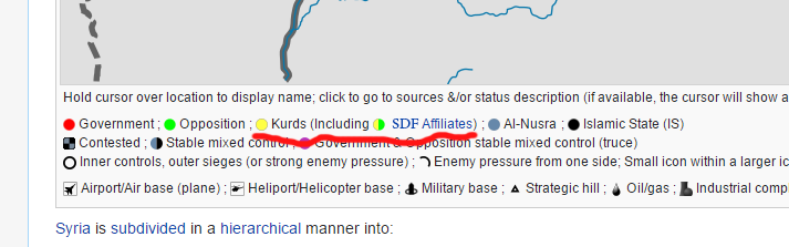
The unsigned comment saying 'who cares what they are' was not mine. It does contradict my comment, but I don't support it. Jaish Fateh groups have a wide range of ideologies, but are a broadly Islamist operations room. They are not a single coherent force, as groups in Jaish Fateh sometimes fight each other outside of the Idlib operations room that they are united in. You say that people will think that the YPG controls everything under a yellow icon, but we clearly indicate on our map that the SDF contains a mix of groups, not just the YPG. If people decide not to read our map and its guide properly and conclude that everything we mark under SDF control is actually under YPG only control, then that is their fault.
If these groups do control - actually control, not just have a few units in the area- areas in Homs province and others, then we should mark them as yellow. However, we will need to find sources indicating that they are controlled by these SDF groups. I agree that a rule is being broken there, and we need to fix it. We should base our own map on our own rules, not the rules of another map that we are not responsible for. If and when the SDF rebels capture Raqqa, we will mark it in yellow. This makes sense. The SDF is actually against the government too - it just has a ceasefire in place in Hasakah and Qamlishi, and focuses on fighting ISIS (and rebels in northern Aleppo, mainly Islamist) at the moment.
Nusra areas should remain grey, because actually, Nusra does have distinct military aims that differ from the main rebels, much like the SDF and IS. IS wants a global caliphate ruled by it, Nusra wants a global caliphate ruled by itself. One of the reasons why they are marked in their own colours is because they are fighting for these aims, not the 'main rebel' primary aim of overthrowing Assad. The SDF serves the Syrian Democratic Assembly, so it is different from the main rebels because it serves that political entity's aims rather than simply trying to overthrow Assad. The main rebels are united by their primary objective being to topple the Assad government. This is one of the reasons why we mark them in different colours.
The joint control icon will be useful if/when non-SDF rebels and SDF rebels share joint control of a settlement, as they did in Afrin recently. If we'd marked all the areas with Jaish Thuwar as joint controlled, then this might have confused people, as it could have overstated the presence of the non-SDF rebels in Idlib, who are not allied with the SDF rebels (unlike Jaish Thuwar and the YPG, which are allied together in the SDF). PutItOnAMap (talk) 22:01, 21 January 2016 (UTC)
PutItOnAMap You have 10 000 Rebel groups in Syria. What do you mean with "They have a different ideology" than the SDF. That doesn't make sense. You need to check again our markings for each color. Green is not "Rebels" but "Opposition". And the SDF is also an oppositon group, a 2nd one. The idea of this map wasn't to separate groups with different plans and ideologies, but by theire origin (i don't mean ethnic, i mean how do they call themself). Imagine it like this. Imagine the SDF wasn't created in Raqqa/Hasaka province, but in south Syria (Daraa), you would change the province to yellow and say "Well, these Rebels are now different than the rest because they are inside the SDF, we can't mark them green no more", you could apply this logic to any other province. The Rebels from Raqqa and East Aleppo province are the same as before the creation of SDF. They were fighting ISIS mainly, because the Gov. withdrew from the province in 2012. The Rebels (SDF) in Afrin canton were fighting against the gov. too, that's why the Gov. withdrew from Afrin canton. The same as Jaish Thuwar in Homs province, they're fighting against the gov. at this moment. You do get my logic ? Rebels are Rebels, they have milion groups, each different than the other. There are "FSA" groups who are as radical as Nusra or ISIS, but who cares, they aren't neither ISIS or Nusra, nor they want to be. That's the reason why Rebels in SDF still use both their and the SDF flag. The Thuwar Raqqa brigade is actually not even using the SDF flag.
Yes, I can. The SDF is fundamentally different from the other rebels not just because of ideology - which is important - but because of their aims. If the SDF has control in areas in Daraa, we should mark them as SDF-controlled. Yes, the SDF fights the government at times, but its purpose is to serve the Syrian Democratic Assembly, whereas the other rebels only want to dethrone Assad: that's all that unites them. [10] The SDF is also significantly different because it has been separated from the Syrian opposition by Saudi Arabiaa, and singled out by Turkey as a group that should not control any territory between Azaz and Jarablus (Turkey has threatened a military intervention in Syria should the SDF go any further west of the Euphrates, e.g. by pushing into Manbij city).
Because the SDF is viewed so differently to the rest of the rebels by most countries, has an entirely different set of political objectives, and is sidelined like IS and Nusra in opposition peace talks, it should have its own colour, no matter where its groups hold territory. The joint control icon should be reserved for instances where non-SDF rebels share control with SDF rebels, which is a far more signififcant occurence than different groups in the SDF sharing control. We cannot confuse these two things. For area, if Liwa Thuwar al-Raqqa and the YPG share control of the area, this is not very noteworthy, and cannot be conflated with if the FSA and the YPJ share control of an area. This is why, in my opinion, joint control should be reserved for non-SDF sharing control with SDF. PutItOnAMap (talk) 11:35, 22 January 2016 (UTC)
PutItOnAMap The new icon is not joint control, because it doesn't exist now. The new icon only looks like a joint control but it will have a new name "SDF". There are 100 Rebel groups which have the same ideology as Nusra but we mark them green. Stop writing pointless POV arguments. We don't, and never cared about that. The SDF needs to have a new color, my suggestion was the previous lime-yellow color. If you have a better idea then write it down. Maybe dark green-yellow ? But only yellow is not enough, because that's not a new color, it was, and always represented either YPG or Kurds in general. DuckZz (talk) 11:44, 22 January 2016 (UTC)
These aren't pointless POV arguments. Nusra is fundamentally different from other rebel groups, even Salafist ones, because it wants to go international. Other rebel groups may believe in the same version of Sunni Islam, but their public aim is not to invade other countries: that is something held only by Jabhat al Nusra and IS. I don't think anyone should be disputing marking Nusra in grey: it is being bombed, unlike the other Salfist groups, by the international coalition, and, unlike the other groups, receives support from Al Qaeda.
All we need to do is change the marker on our map to Yellow = SDF. Then, anyone who can read will know that it represents the SDF, not just the YPG or the Kurds. I do not want to mark separate areas for YPG-only control and SDF control, as the forces operate together. For instance, the Syriac Military Council can move around freely in any SDF territory, as can Liwa Thuwwar al-Raqqa. This freedom of movement and the connection of their operations is what makes the SDF a single military entity, and thus not entitled to a joint control icon - or, for that matter, 'special' icon for where the YPG shares with other groups. PutItOnAMap (talk) 11:56, 22 January 2016 (UTC)
Sûriyeya This is our latest map. This map needs to look the same (more or less). The user Bruskom explained some things when he wrote this. The SDF needs a new color. It can't be too different, but it also can't stay the same. I already wrote my opinions, and the difference is, i don't care if my opinions are stupid or not, but if they are, then the rules of this map are stupid too because i didn't made them. My edits in Idlib were reverted, my edits south of Tall Abyad were reverted, so that only means, if those users ignore the rules, then I have all the right to do another edit, but this time in Raqqa province, the only difference is that I will not breake the rules and don't have to fear anything. The joint control icons doesn't exist anymore, only the Rebel-Nusra icon is still here, everything else can't be used. For example, Gov-Rebels(JAN) joint icon can't be used, because we have a truce icon. The joint control Rebel-Kurd icon also can't be used, because we have a new coalition of Rebels and Kurds. This only means that the SDF will have the Yellow-Lime icon, which will be called "Syrian Democratic Force" and nothing else. The SDF is not present in Qamisli area, neither in Sheikh Masud, also the YPG does 90% of the job in south Hasaka. All these things make it only easier. As I'm currently the oldest editor here, i will see later if this works, but I'lle wait for your opinion. DuckZz (talk) 23:56, 23 January 2016 (UTC)
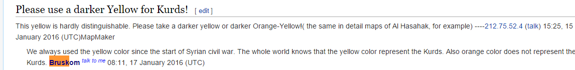
Az Zarrah and Al Zarra
Are these two places the same? They have the same coordinates, but different icons, and the advancement on one location called Al Zarra (which can alternatively be spelled as Az Zarrah, I think?) by the SAA was reported by Al Masdar today. Should we delete one of them and keep the other? I think someone has added a different icon unnecessarilly when they saw an alternative spelling for the name of the same place. PutItOnAMap (talk) 10:33, 21 January 2016 (UTC)
- Yes, they are the same place. Delete the icon with the less commonly occurring name. LightandDark2000 (talk) 06:16, 24 January 2016 (UTC)
Qadam
AlMasdar reports that the first phase of the truce in south Damascus and SAA took control of Qadam. In the next future, IS should leave, palestinian factions control their camps jointly and FSA control Hajar al-Aswad. Qadam should go red, but the Damascus map is frozen and nobody is updating it.Paolowalter (talk) 21:33, 20 January 2016 (UTC)
If there is a truce there, we should mark it in purple. When the truce has expired, we will change it to red. PutItOnAMap (talk) 11:58, 22 January 2016 (UTC)
There was a truce. Now Qadam is under control of the government. It must go red. The palestinian camp should go purple (or red). Hajar al-Aswad should go purple.Paolowalter (talk) 22:13, 23 January 2016 (UTC)
Agree Qadam to red Hajar al Aswad to purple .MR PENQUIN20 where are you ? Damascus city map is so behind with events its becoming a joke .If a solution to update this city map faster can not be found it should be discontinued and a different map that is easier to update added .86.178.102.49 (talk) 12:39, 24 January 2016 (UTC)
Lattakia Northern Countryside
According to Armenian source a mostly Armenian populated village of Ghnemiyeh is under SAA control. Also according to Al Masdar Beit Sakr and the Electronic Battalion base in the Turkmen Mountains are under SAA control.--Dimitrish81 (talk) 15:52, 22 January 2016 (UTC)
SAA captured: Beit Zayfa, Beit Khadour, Al-Sabihiyah, Qasr Al-Jourah, Khan Al-Jouz, Baghtos, Ras Al-Ghazal, Katf Kamoa, Khanda Morek, Ghunaymiyah, ‘Ara , Al-Riyaniah, Al-Sawda, Bayt Awan, Al-Rihaniyah, Baldar, Bayt Riha, Al-Qalaye', Ketf Al-Qamoo', Burj Al-Rahmaliyah, Al-Sukkariyah Al Hawr, Beit Sakr, Baradoun Mountains (Jabal Baradoun), Baradoun Dam, Electronic Battalion army base, al-Rahima tower.SOHRSOHRSOHRSOHRSOHRSOHRAl MasdarAl MasdarAl MasdarAl Masdar Sûriyeya (talk) 17:23, 22 January 2016 (UTC)
Correct me if i am wrong but their is no representation in the map. Also in the Damascus map we are stuck a little bit.--Dimitrish81 (talk) 18:19, 22 January 2016 (UTC)
The Latakia offensive map should be updated soon. Oroszka (talk) 18:34, 22 January 2016 (UTC)
We definitely have representation of some of those places - myself and other users have put them up there. Try purging the cache if it doesn't show on your map; that worked for me. PutItOnAMap (talk) 19:10, 22 January 2016 (UTC)
I am not doubtful about intentions however there is poor representation of the area where we have the most fragile ground. According to Al Masdar we have new advance of SAA and capturing of Qatar in East Aleppo and Al Tafahiyah in Northern Latakia.Also as i posted before about Damascus (Eastern Ghouta Area) there is change since 10 days ago without updating. I clear the server cache in the main map but i didnt find such a choice in the city maps--Dimitrish81 (talk) 15:02, 23 January 2016 (UTC)
- SOHR said that SAA captured villages of Al Hulwah and Tafahiyah.here Sûriyeya (talk) 15:27, 23 January 2016 (UTC)
- After the capture of Rabia by the SAA an a series of villages adjusted to it today, we still can see in the map two small green marks of a village and a height???? which are controlled by rebels???? Please advice if these is map mistake or is there really rebel presence.--Dimitrish81 (talk) 09:59, 24 January 2016 (UTC)
- Opp.source SAA captured over the town of Rabia.here Sûriyeya (talk) 10:24, 24 January 2016 (UTC)
- SOHR: Rabia, Torus, Darwisha, Rawda taken SAA.here Sûriyeya (talk) 13:02, 24 January 2016 (UTC)
Al Dumayr heavy fighting between terrorists groups
Acoording to Al masdar the foreign terrorists are fighting with each other in Al Dumayr why is this area under truce they are still fighting with Government and each other: http://www.almasdarnews.com/article/islamists-go-to-war-with-each-other-in-the-east-qalamoun/
=========== When you have two different groups of rebels fighting each other, how do we show on the map that it is contested? This is a tricky problem. Maybe we could mark places where that is happening in a colour which we label 'rebel internal conflict'? PutItOnAMap (talk) 12:56, 23 January 2016 (UTC)
- PutItOnAMap This town located in SAA-held area and where SAA and rebels reached truce but for now rebels fitgh among themselves for control of the territory inside the city. So maybe we can mark him in green color and put red circle around town. Sûriyeya (talk) 14:57, 23 January 2016 (UTC)
There are Jabhat Al Nusra allies vs FSa faction there is an icon for this as there has been instances in the past suggest to put it Grey/Green contested.
The second point is a good idea, but are they just allies of Al Nusra, or part of it. If it's the latter, then we should do grey/green. If not, we should use green and another colour, but not grey.
I think we should go with talk's idea for now. PutItOnAMap (talk) 20:22, 24 January 2016 (UTC)
US Airbase in northeastern Al-Hasakah Province
Can someone please add the recently-completed US airbase in northeastern Al-Hasakah? The US is going to use it to closely support the SDF, and now that it's fully operational, I think that it should be included on the map.
LightandDark2000 (talk) 02:43, 24 January 2016 (UTC)
- Oh... It's already on the map. How nice. LightandDark2000 (talk) 02:53, 24 January 2016 (UTC)
It's not quite fully operational yet, I think. From what I've read of it, though, it's nearly complete. PutItOnAMap (talk) 20:53, 24 January 2016 (UTC)
Kurdish forces prepar create the joint management Russian - Kurdish military room in Afrin
SOHR: According to the Kurdish source that «the level of Russian cooperation - Kurdish proceeding according to ascending curve» and they prepar create the «joint management Russian - Kurdish room» in Afrin north of Aleppo.here Khalifa trooper (talk) 11:12, 22 January 2016 (UTC)
- Khalifa trooper Not quite right! These data taken from an anonymous source which is provide some data but not provide proof of these data. Read carefully the article. Sûriyeya (talk) 11:42, 22 January 2016 (UTC)
- Sûriyeya But the source is not say that his data are unconfirmes so just us need to more infos. And I good read source. Khalifa trooper (talk) 11:49, 22 January 2016 (UTC)
- SOHR is a very reliable source regardless. LightandDark2000 (talk) 06:15, 24 January 2016 (UTC)
- Sûriyeya But the source is not say that his data are unconfirmes so just us need to more infos. And I good read source. Khalifa trooper (talk) 11:49, 22 January 2016 (UTC)
SOHR is reliable, and according to the conversation here (I can't read the article because I don't speak Arabic, unfortunately), it is only reporting an anonymous source reporting something else. Therefore, although it is reliable, its unconfirmed reports from this other source are not. PutItOnAMap (talk) 20:55, 24 January 2016 (UTC)
FSA-Southern Front in Daraa gov. agree to stop fight against regime troops and start fight against Al Nusra
The Amman-based Military Operations Center (MOC) that helps coordinate rebel operations in southern Syria has ordered Free Syrian Army-affiliated factions to stop attacking regime forces and instead focus their efforts against the Al Nusra. The FSA-linked groups were told by Jordanian, US and British intelligence officials to “stop operations against the Syrian army and avoid periphery battles,” in reference to intermittent rounds of fighting between the rebels and ISIS-affiliated groups in southern Syria. Instead, the Southern Front factions present in the Amman meeting—as well as the allied Army of Free Tribes group backed by Jordan—were instructed to concentrate on fighting both the Al-Nusra Front and Islamic Muthana Movement, which is close to the Al-Qaeda affiliate. “The decision to liquidate the jihadists in the south has been taken.”The foreign powers operating the MOC promised rebels renewed aid in return for them agreeing to change tracks and launch a major campaign against Nusra. “Each faction that joins the campaign will receive five tanks with full training for their crews as well as other incentives related to salaries and armament,” sources told the pro-Hezbollah daily. The rebel leaders present in the Amman meeting all agreed to the MOC’s new plan, except the Youth of Sunnah Brigade chief, who eventually consented following further guarantees of support. source Sûriyeya (talk) 20:58, 20 January 2016 (UTC)
- It hasn't happened yet, as far as I know. But if it does, we can expect to see some serious changes on the battlefield in southern Syria, and likely some major clashes erupting between al-Nusra and the FSA's Southern Front. LightandDark2000 (talk) 08:01, 25 January 2016 (UTC)
Arbid al Judaydah
Please change "Arbid al Judaydah" and "Ayn al-Jahsh" to red ----212.75.52.4 (talk) 13:01, 25 January 2016 (UTC)MapMaker
Sharan in Latakia
I think that the rebels leave village Sharan to Rabia before the town Rabia was taken SAA. After SAA/allies captured allmost all villages west of the strategic town of Rabia most likely village Sharal also taken SAA. Sûriyeya (talk) 10:30, 24 January 2016 (UTC)
- So it is unlikely they will remain in the village Sharan and wait siege. Most likely they were evacuated after the loss of the neighboring villages and the loss of the city of Rabia. This also applies to a small hamlet of Dagdagan which consists only of the several houses. Sûriyeya (talk) 12:39, 24 January 2016 (UTC)
- Also Jabal Qaya Bashi should be made red as it would logically have been captured by SAA during the Lattakia offensive.91.85.60.235 (talk) 13:17, 24 January 2016 (UTC)
Tartiyah has been under SAA control since fall of Salma, strange oversight in this map! 13:48, 24 January 2016 (UTC)
- It's the same situation like in North Aleppo with the village Murayghil where it's shown rebel,if we speak logically than yes this village has fallen.Lists129 (talk) 14:23, 24 January 2016 (UTC)
Well, I suggest that we introduce a new policy for places that end up behind enemy front lines, aren't very large or defensible (unlike Nubl and al-Zahraa) and are not reported on. These include places like Murayghil and Sharan. We need to keep in mind that they may not warrant enough media attention to have their recapture reported if everything else is taken around them. Their capture will be seen by many media groups as a 'given', so to speak.
Therefore, after a certain time limit, if we receive no further information on them, we should change them to the colour surrounding them. Of course, if we then get later updates suggesting that they are still there, we can change them back. Note that this rule should not apply in the SAA's isolated pockets in Hasakah province, because obviously the SDF isn't trying to take territory from them there at the moment, so even if their small areas are not reported on, we should presume that they are still SAA-held.
The main question to be answered here is what this time limit should be - of course, we have to give the media ample time to report on this issue before we presume that a place has been captured. Maybe we should give each place a week encircled, and then we change it to the surrounding colour. If a majority of editors here agree with this idea, we can change Sharan soon, and Murayghil too. Of course, the time they can be changed depends on the time the places surrounding them were taken by the SAA/IS, but they still should be changed. PutItOnAMap (talk) 20:19, 24 January 2016 (UTC)
- PutItOnAMap In situation with Sharan we have data from reliable sources including SOHR that area wher located Sharan taken SAA. And some opp. source said that rebels yesterday retreated to Rabia in attempt to repell SAA advance in Rabia. Also do not always sources say about every village separately. Sources only said that this area SAA-held. Also we do this in situation when sides in conflict with each other. In Hasakah some kurdish sources clear indicated that some points to west Hasakah still under jointly control or SAA-held. In situation with Murayghil we only have data from one of pro-opp. sources that rebels captured the village from ISIS. So it is not a new rule but you partialy right if point located deep in area which is under control enemy side and it is not a army base/military airport or no data that this point(village or facility) in siege we are can change status for this point. Sûriyeya (talk) 21:14, 24 January 2016 (UTC)
- I agree. That was done informally in the past as well. Especially for small locations or peaks.79.21.206.111 (talk) 06:48, 25 January 2016 (UTC)
All right, I'll change them both for now. In the case of larger settlements, they should stay the same colour, because cities such as Nubl are defensible even when surrounded, despite not having army or air bases.PutItOnAMap (talk) 21:19, 24 January 2016 (UTC)
- PutItOnAMap Plus SOHR clear said that the SAA Operations Room to advance and take control of 36 towns and villages, where towns of Salma and Rabia are the most important towns of them all because they are the main stronghold for the factions in Jabal al-Akrad and Jabal al-Turkman, some of the towns and villages controlled by Regime Forces Operations Room are al-Hoor, Khan al-Joz, Beit Miro, al-Ghnimeh, al-Maruniyyat, Marj Khokha, Dwoerkeh, Taoma, al-Mryj, al-Rihaniyya, al-Helweh, al-Drwaishan, Beit Ablaq, al-Durra, al-Sekkariyyeh, Beit Arab, al-Teffahiyyeh, al-Sawda (Qara Bejeq), Beit Hamik, Beit Awan and Braddon area and other villages and areas in both mountains.here So that SOHR donfirmed that the area where loated those villages in Latakia under control of SAA. Sûriyeya (talk) 08:31, 25 January 2016 (UTC)
- PutItOnAMap SOHR said that the SAA advance in Jabal al-Akrad and Jabal al-Turkman, and captured the villages and towns of al-Hoor, Khan al-Joz, Beit Miro, al-Ghnimeh, al-Maruniyyat, Marj Khokha, Dwoerkeh, Taoma, al-Mryj, al-Rihaniyya, al-Helweh, al-Drwaishan, Beit Ablaq, al-Durra, al-Sekkariyyeh, Beit Arab, al-Teffahiyyeh, al-Sawda (Qara Bejeq), Beit Hamik, Beit Awan and Braddon area and other villages and areas in both mountains.here So that probably rebels retreated to Turkey and to Idlib province. Other reliable source said that the without Al-Rabi’yah and Salma the rebels are left with only two heavily fortified villages in Jabal Al-Akrad: Kinsibba and Kabani.here Sûriyeya (talk) 08:43, 25 January 2016 (UTC)
- PutItOnAMap Plus opposition source said that the Some FSA brigades already leaving Latakia governorate frontlines. Now reinforcing western Idlib governorate borders. FSA and other factions evacuated to Aleppo and Hama. FSA, Islamic Front,Al Nusra and small jihadis groups clearly withdrawing from Latakia.hereherehereherehere So as said other source just only Kinsibba and Kabani naer with border of Idlib province are still rebels-held. Sûriyeya (talk) 09:38, 25 January 2016 (UTC)
You mentioned Kabbani, which I cannot find on our map. I'll add it momentarily. PutItOnAMap (talk) 14:58, 25 January 2016 (UTC)