This is an archive of past discussions. Do not edit the contents of this page. If you wish to start a new discussion or revive an old one, please do so on the current talk page.
The City of al Quarytayn has the same urban area as city of palmyra, but in map the dot is small as mahin ,if you check on wikimapia actualy you can see its real size.
Same thing with Maskanah , its dot size almost looks like a village .
Please make the maskana dot same as Deir Hafer , And Al quaryatn same as it was before , somewhat like palmyra dot — Preceding unsigned comment added by AlexanderM1 (talk • contribs) 16:29, 7 June 2017 (UTC)
It could get messy. I personally would not recommend that, unless the battle situation in Raqqa gets really complicated. Raqqa city is not even as big as any of the other cities with detailed battle maps (except for possibly Qamishli), so any action in Raqqa city specifically could become rather hard to see. In any event, the SDF haven't fully pushed into Raqqa city yet. LightandDark2000 (talk) 02:44, 8 June 2017 (UTC)
LightandDark2000Refugee Camp in Syria is it neutral places for Syrian refugees which leave they homes and these camps under protection UN and other charitable and human rights organizations! No one of side in Syrian conflict not control those places. In Syria several tens refugee camps and we not need put them on map. Mehmedsons (talk) 06:43, 9 June 2017 (UTC)
Technically, the territory on which this refugee camp sits is under "Free Syrian Army control", so it is currently marked as being under rebel control. The camp probably isn't actually run by the FSA (probably the UN), but for the sake of distinguishing frontlines, we might as well say that it "under rebel control" on this map. The Al-Hawl Refugee Camp in the Al-Hasakah Province is actually run by the SDF, and so it is marked yellow, but this is a slightly different case. They're supposed to be neutral, but that doesn't stop people from attacking the refugee camps (esp. HTS and ISIL forces), and someones does control the land around the camp, if not the camp itself. LightandDark2000 (talk) 07:33, 9 June 2017 (UTC)
I added this camp because it's a large camp and it's near a major Jordanian-Syrian smuggling route. Besides that, ISIL has suicide-bombed the camp quite a number of times recently, and the Syrian Government is advancing towards it, so whether or not the camp is evacuated, if the SAA forces continue advancing in that direct, eventually, the location of the camp will become contested itself. LightandDark2000 (talk) 07:35, 9 June 2017 (UTC)
A lot refugee camps at Turkish border and we never add them on map even when was try ISIS attacked of them or when they take some of them. And we have on the map FSA controlled Rukban border crossing which located at distance nearby half km from Refugee camp. This confirmed the fact what FSA controlled this area. And we also need remove Hulwa Refugee camp in Hasakah. We not need add any of refugee camps. Mehmedsons (talk) 11:18, 9 June 2017 (UTC)
I think that refugee camps are worthy to be added on the map, because refugee crisis is an important part of this war. We could add a new colour for refugee camps like a light blue (like UN colour) and a new icon. Furthermore according to official rules of this map, the size of the points are based on the population of the city/town/military base/powerplant etc. And many towns lose population due to refugee crisis. Some town like Latarminah or Qaryatayn have large dots while they have no more population and actually are large military bases. And some refugee camps are more populated than many towns and hamlets marked on this map. So it's important to add them on this map. — Preceding unsigned comment added by 82.233.227.191 (talk) 15:05, 9 June 2017 (UTC)
It is map showe military situation at Syrian and if you do this we will too clutte map. Maybe we just need a separate map reflecting the situation with refugees. On this map, we reflect the areas which controlled of different parties in the Syrian conflict and not the situation with the refugees. Mehmedsons (talk) 17:53, 9 June 2017 (UTC)
Extended-confirmed-protected edit request on 13 June 2017
Is just a data from the anti-government activist group. No any confirmation and according several sources SAA advance south of Bir Anbaj and take several other points. Mehmedsons (talk) 10:09, 14 June 2017 (UTC)
The clashes in Maarrat al-Numan are still raging between HTS and the FSA and its allies (e.g. Faylaq al-Sham and Ahrar al-Sham). HTS hasn't fully captured the town yet. We need to keep a close eye on this battle, given the significance of the city. I suggest creating a new article for this battle, something like Third Battle of Maarrat al-Numan if these clashes continue to persist, especially if they intensify or spark a larger inter-rebel conflict. Here is a recent source stating that the clashes are still ongoing: [1]. LightandDark2000 (talk) 02:32, 10 June 2017 (UTC)
Are you sure? The battle appeared to have ended a few hours ago. According to this a ceasefire agreement was signed. I agree that we still need to wait a while though, as few sources have came out. Because of the lack of reliable sources, not much info can be put together for a new article, and additional info in the aftermath section of the Second Battle of Maarat al-Nu'man may be sufficient. Editor abcdef (talk) 03:05, 10 June 2017 (UTC)
The situation is still quite volatile in the city right now, and there are probably still some clashes occurring, whether it is waged by FSA fighters or angry civilians, even if there was some kind of "ceasefire." It's a good idea to wait for more information, especially since this is progressing so rapidly. LightandDark2000 (talk) 04:20, 10 June 2017 (UTC)
Okay, according to this source, a ceasefire has been negotiated between the Free Idlib Army and HTS. The conditions are that HTS will be allowed to disband the Division 13 FSA group, but in return, HTS must completely withdraw from Maarrat al-Numan. LightandDark2000 (talk) 23:37, 10 June 2017 (UTC)
The agreement was to have HTS withdraw within several days. Judging by HTS fighters and other signs in the city, it hasn't been fully implemented yet. Division 13 is also planning to instigate civil resistance in the city. It's still too early to colour it fully green. Shared control would be more accurate.
Also, the agreement stated that all armed groups are to withdraw from Maarat al-Nu'man by the deadline, not just HTS. How should we deal with this? Editor abcdef (talk) 04:11, 11 June 2017 (UTC)
If all groups really withdraw from the city, just put it green, just because rebellion flag is still floating on the city — Preceding unsigned comment added by 82.233.227.191 (talk) 20:44, 11 June 2017 (UTC)
TheNavigatrr According to anti-SAA source - SAA controlled Jubb al Jahlan,Al Hawrah and Bir Akhu Hadlah not SDF.link And Local source Al Masdar claimed Bir Akhu Hadlah and Bir Hajj al Mufazi controlled SAA.linkMehmedsons (talk) 19:54, 17 June 2017 (UTC)
We cant use obsolete sources to change control of points!
I just watched and did nothing but is it go on like this. We cant use obsolete sources for chang status!
Here is Niele~enwiki SAA controlled villages noted as SDF controlled:
Qibab al Kabir, Qibab al Saghir on based sources at 27 February 2017linklink
Ras al-Ayn Humurbut on based sources at 3 March 2017link
Arbaah Kabirah and Arbaah Saghirah on based sources at 27 February 2017, 1 March 2017 and 28 August 2016linklink
Judaydat al-Humur on based sources at 21 August 2016, 21 January 2017 and 3 March 2017link
But source at 7 March 2017 confirmed that these villages controlled SAA. Here this sourcelink
And SAA controlled villages Al-Sukhni and Arudah Kabirah were noted as SDF controlled on based the source at 27 February 2017 but at this time they was still controlled ISIS and SAA take back them just at 7 March 2017.link Soon someone can will make changes on based the sources for 2014 or 2015!? Mehmedsons (talk) 08:47, 2 July 2017 (UTC)
You used a very unrealible map-source that guessed the control of these previously individually sourced villaged from SDF to SAA.
This was reversed by me because you can't use a mapsource to change a large amounnt of villages that where previously individually sourced otherwise.
I don't even had to give sources to revert this. They where sourced when they where captured from Daesh by SDF. You changed them from SDF to SAA without any reliable source.--Niele~enwiki (talk) 10:26, 3 July 2017 (UTC)
Niele~enwiki I use data from article not just from a map. So I not a break of any rules of edit. But you used very outdated sources for your changing. I not revert entire you changes because not want provoke conflicting situations. So let's leave it as that. And never more will not use obsolete sources to change control of points! Mehmedsons (talk) 12:42, 3 July 2017 (UTC)
Source of 7 March reported that the forces of the regime took control of the many villages. Here is a list of these villages on Arabic:"( رسم الأحمر و جب القهوة و العباجة و رسم البوخر و كيارية و أم رسوم و المشرفة و تلة الصلمة و خربة الشهاب و الريحانية جنوب غرب بلدة الخفسة و معراضة كبيرة و الدخيرة شمالها )
كما سيطرت قوات النظام على قرى ( خرجيس – رباية – أبو خطر – جناة السلامة – أربعة كبيرة – أربعة صغيرة – محسنة – جديدة – مزرعة – قباب كبير – جنات صغير – رأس العين الحمر – تل أبو جدحة – خان الحمر – تل أسود – شعيب – شيخ أبيض – عنيكبان – تل أبو جدحة )" Mehmedsons (talk) 13:13, 3 July 2017 (UTC)
Abu Kahf was confirmed to be captured by SDF.Alhanuty (talk) 16:20, 3 July 2017 (UTC)
TheNavigatrr You must be joking !? You Twitter sources at the 28 February and 2 March 2017 sayed SDF controlled Abu Kahef. But two the reliable local sources SOHR and Al Masdar at 2 March and 5 March 2017 confirmed that this village controlled SAA. Mehmedsons (talk) 07:03, 4 July 2017 (UTC)
But if some one in July 2017 try use source at 2014, 2015, 2016 or January,February 2017 for change control of some points is it must be prohibited. I agree that sometimes also and the most crediable sources make mistake but twitter sources make them much more often. Mehmedsons (talk) 15:14, 6 July 2017 (UTC)
Some of twitter sources more crediable, some less reliable and a lot of the biased unreliable. We can't called a twitter sources as "most proven-reliable sources". Just some a crediable and some not. Mehmedsons (talk) 16:59, 6 July 2017 (UTC)
What is your standard for local sources, Mehmedsons? On multiple occasions, you cite Al-Masdar (a pro-government outlet in Damascus) as a local source! Here, here, here. In fact, you have made more than 30 edits in the past months, most of them in favor of the government, based on you saying Al-Masdar is a "local source"! If you are going to call Syrian military officers (the source of those reports) and a pro-government Damascus news agency a local source, then surely photographic and video evidence from the actual site of the airstrikes counts at least as much as that, if not more. And the word of activists who are actually from these villages reporting these things should count as much as Al-Masdar. Besides, the Syrian government never claimed to control these villages anyway. Most of them are quite a bit far from the front line. If we can't use these sources for rebel control, then we can't use Al-Masdar for government control, as they're biased and they aren't even local. TheNavigatrr (talk) 17:56, 6 July 2017 (UTC)
And again your not try to understud! SOHR and Al Masdar are local source. But we cant called entire twitter sources as local. No need to addition villages too close of frontline on based obsolete or pro-opposition sources. Is it a very delicate matter and can provoke a lot of problems. Mehmedsons (talk) 19:02, 6 July 2017 (UTC)
At our map FSA also is it still not besiged. And as we all know in our rules noted the "maps from mainstream media are approximate and therefore unreliable for any edit".Mehmedsons (talk) 05:56, 14 July 2017 (UTC)
I'm all for lightening up of the map, but erasure of front-line towns along all the various entities controlling Syrian territory is downright stupid, and subtracts from the objective of having a useful, uncluttered map. 66.108.212.6 (talk) 21:57, 26 July 2017 (UTC)
What have happend to the Template?
The headline says it all. what is going on? (unsigned)
All towns, places inside the overview map are included into the detailed map.
But from now only towns, places from the overview map in to the module:Middle_East_conflicts_detailed_map.
This is because with Middle_East_conflicts_detailed_map broke down because it could not handle the large amount of detailed data.
There is still an error in the Module:Syrian_Civil_War_detailed_map resulting in all villages beyond line 2700 are not rendered on the map.
We are currently working in understanding and solving this, any help to solve this is handy.--Niele~enwiki (talk) 16:46, 26 July 2017 (UTC)
The anon is probably asking about your accidental removal of entire regions of markers from both maps, Niele. Nuke (talk) 17:50, 26 July 2017 (UTC)
No markers where removed, these where server-cache problems but they are resolved and the modules are all working fine now! --Niele~enwiki (talk) 00:33, 27 July 2017 (UTC)
The current map is totally useless -> Fixed
I agree with the fact that the map is now overloaded and the need of a lightest map. But the divison of the map in two modules is completely mudding the map and it's now impossible to correctly follow the actuality. It's now impossible to follow the current SAA offensive in central syria and many important tows are now invisible (Hassakah for exemple).
The best and the most natural solution will be the following:
- to remove dots of closed fronts (ex: northern Latakia)
- to remove hills and hamelets of the syrian Badia, central Syria and largely use the icon "rural presence" instead
- to remove at least 3/4 the hammlets of the the Afrin region
- keep the villages and towns along the highways, the major roads, the rivers, and broadly the most populated areas and use "rural presence" icon in
 the desert
- remove the detailed map from Qamishli and replace it by a mixed control dot (closed front)
- remove the Aleppo detailed map and replace it with a big red dot and a smaller yellow dot for sheikh Maqsoud
I'd like to do that job myself but I don't know how this map is working and I'm unable to do a single edit on the map. So I want to told to the editors that its very important to do that job to allow the broad people to follow the actuality with a single glance which is impossible on the current map. If the map stay like that I and many people will be forced to stop following this map, which it's a pity because it was the most accurate and dynamic map of the conflict. Thanks everyone.
Map is fully functional in all ways and all issues are solved.
No need to delete any village or place anymore. Deleting villages is history because there is no size-limit needed for the detailed map.--Niele~enwiki (talk) 13:41, 27 July 2017 (UTC)
Make Raqqa inset map File:Battle_of_Raqqa2.svg
The current Raqqa inset map has Arabic labels to indicate the different parts of the city. File:Battle_of_Raqqa2.svg has the English labels. The current Raqqa map also suggests in its description to use File:Battle_of_Raqqa2.svg for the template. Redditor555 (talk) 05:45, 24 July 2017 (UTC)
There are still weird issues. Around the Raqqa/Deir-Ez-Zor border, there are a lot of overlapping place names, so that it's impossible to see what the texts say. Esn (talk) 18:08, 30 July 2017 (UTC)
201 unverifiable sources which must be removed, along with their text
All of the "template:cite" references list no sources and should be removed, along with the unverifiable text. Or of course replaced with real sources. Doug Wellertalk18:36, 21 September 2017 (UTC)
Even on a wide screen, this is causing left to right scrolling required, zooming sufficiently to see the map makes the text unreadable. Can this be scaled down on the article display? — xaosfluxTalk13:38, 22 September 2017 (UTC)
And as I've said before, this article should be accessible by those with low bandwidth, which includes probably most of the people in the area affected. As it is, the article seems to discriminate against them. Doug Wellertalk18:29, 23 September 2017 (UTC)
Given all the above, we should not transclude the overview map into the article. The tables of the article are already huge. When you add to them the map, the combination becomes unmanageable for many of our users and leads to the crashing User:霎起林野间 above is talking about. I have therefore removed the map from the article and replaced it with a link to the template. Tradediatalk07:33, 25 September 2017 (UTC)
Is it still crashed? In that case, most of the recent village additions (especially minor ones) should be removed. I did state a size limit on the main page of the module in the "Rules" section. If it has been exceeded, then that means that the module has become too large for Wikipedia's servers to support. Either way, this module seriously needs to be trimmed down. LightandDark2000 (talk) 08:39, 25 September 2017 (UTC)
Extended-confirmed-protected edit request on 29 September 2017
Not done: it's not clear what changes you want to be made. Please mention the specific changes in a "change X to Y" format. — JJMC89 (T·C) 00:39, 30 September 2017 (UTC)
I think it's time to separate out the Turkish-backed Free Syrian Army from other rebel forces.
I have just modified 5 external links on Cities and towns during the Syrian Civil War. Please take a moment to review my edit. If you have any questions, or need the bot to ignore the links, or the page altogether, please visit this simple FaQ for additional information. I made the following changes:
When you have finished reviewing my changes, you may follow the instructions on the template below to fix any issues with the URLs.
This message was posted before February 2018. After February 2018, "External links modified" talk page sections are no longer generated or monitored by InternetArchiveBot. No special action is required regarding these talk page notices, other than regular verification using the archive tool instructions below. Editors have permission to delete these "External links modified" talk page sections if they want to de-clutter talk pages, but see the RfC before doing mass systematic removals. This message is updated dynamically through the template {{source check}} (last update: 5 June 2024).
If you have discovered URLs which were erroneously considered dead by the bot, you can report them with this tool.
If you found an error with any archives or the URLs themselves, you can fix them with this tool.
Do you think a new colour should be added for Turkish backed rebels? Since part of the Northern Aleppo and Idlib Provinces are controled by Turkish backed rebels with a different agenda that the rest of the FSA.Mr.User200 (talk) 12:38, 20 October 2017 (UTC)
Turkish troops colour
Hi, the legend below the map does not specify that dark green signifies the Turkish army (it only mentions red, light green, yellow, grey and black). Can somebody please add that? I'm not sure how to do it myself. Esn (talk) 08:20, 2 November 2017 (UTC)
I have just modified 2 external links on Cities and towns during the Syrian Civil War. Please take a moment to review my edit. If you have any questions, or need the bot to ignore the links, or the page altogether, please visit this simple FaQ for additional information. I made the following changes:
When you have finished reviewing my changes, you may follow the instructions on the template below to fix any issues with the URLs.
This message was posted before February 2018. After February 2018, "External links modified" talk page sections are no longer generated or monitored by InternetArchiveBot. No special action is required regarding these talk page notices, other than regular verification using the archive tool instructions below. Editors have permission to delete these "External links modified" talk page sections if they want to de-clutter talk pages, but see the RfC before doing mass systematic removals. This message is updated dynamically through the template {{source check}} (last update: 5 June 2024).
If you have discovered URLs which were erroneously considered dead by the bot, you can report them with this tool.
If you found an error with any archives or the URLs themselves, you can fix them with this tool.
I've been quite inactive during the last time, but I think there is a topic that needs to be discussed.
I know that there was a discussion before about it, but the situation has changed, especially since the intervention in northern Idlib.
The Template should show the areas occupied by Turkish military in an own colour.
Why do I think that? The threat of IS in the Shehba plain north of Aleppo has long disappeared.
The area is more and more included into the Turkish system. The aim of the groups there is no longer the liberation of Syria, it's meant to become a Turkish protectorate.
The Turkish intervention in Idlib shows even more clear, that the alliance is not against Assad but against the SDF.
This aims are different to other rebel groups in Idlib, which have - while opposing SDF as well - fighting Assad and his army as first priority.
On the SVG-map, you can already see the area controlled by Turkey and allied militias, but I will change it back to green until we have a consent here.
@Mehmedsons: Haha, I understand you got confused by my edit on the Link of Suran, Hama, however it was correct and I reverted your revert of my edit. The thing is that someone (not me) put {{anchor|Sawran, Aleppo Governorate}} at the line describing the town “Suran” on the article Cities and towns during the Syrian Civil War. So for the link of Suran to work, we need to refer to exactly the words in {{anchor|Sawran, Aleppo Governorate}}. The words do not matter as long as they are the same in the {{anchor}} and in the link =. So for example, I changed both for “Suran” town to “The Great Mehmedsons”:
In this edit I change {{anchor|Sawran, Aleppo Governorate}} into {{anchor|The Great Mehmedsons}}.
Needs to be changed from m.JaN_hill to m.gov_hill, due to the fact that this is part of the former Beit Jinn pocket, and the rest of the Beit Jinn area is already marked red. TheMapLurker (talk) 19:22, 30 December 2017 (UTC)
As one of the Sochi agreements is Syrian army permitted to advance till the railway in Idlib, could anybody please add the Syrian railway into the map? Ghadamgahy (talk) 14:55, 30 January 2018 (UTC)
It looks like the map finally broke, due to over-complication. Sorry, I am not knowledgeable enough about this module stuff to be able to help. - Wiz9999 (talk) 04:34, 7 February 2018 (UTC)
Good job @Mehmedsons, well done! :) Now let's think about reducing the number of overall dots to prevent this from happening again, and to reduce lag... - Wiz9999 (talk) 19:41, 7 February 2018 (UTC)
@Wiz9999 I'll take care of this! I have already deleted some checkpoints, grain silos and some other objects. And in future I'll will watch for the map and will fix any mistakes.Mehmedsons (talk) 19:57, 7 February 2018 (UTC)
Possibly reducing the number of points
Since the map crashed, should some of the small points away from the front line be removed? For example Northern Latakia has a lot of really small points that are hard to even hover over. Some of the line of border garrisons could probably also be removed, maybe every other one, leaving the ones farther north ones. There are other areas that also have a lot of points that are unlikely to change anytime soon as well. I understand that some people feel all of the points should stay, but if the map keeps crashing, having all of the points doesn't help, especially if new points can't be added. Emk9 (talk) 20:36, 7 February 2018 (UTC)
Aleppo/Qamishli Minimaps
Now that SAA enjoys total control over Aleppo City (apart from Zahraa District), can we just have a large red dot for Aleppo and do away with the minimap? It seems unnecessary to have a minimap for a city that one faction has 99% control over - Hasakah minimap was removed for this reason.
Yes, it would create issues with the road map - speaking of the road map, there is a box to the east of Aleppo that isn't transparent like the rest of the image file, but I'm sure it was added to reduce the visible size of the Aleppo minimap - since some roads would terminate just before reaching the red dot, but surely someone could easily extend the roads into the blank box where Aleppo is.
And while we're at it, can we do away with Qamishli minimap? Nothing happens there except for the occasional bombing. It seems redundant to have a minimap for a city where the last conflict was back in 2016. Of course, there would have to be more dots added in for SAA control, but not many would have to be added.
If there is a conflict in Qamishli pocket in the future, the minimap could simply be added back.
TheMapLurker (talk) 14:02, 23 February 2018 (UTC)
Tal Rifaat
It shows in the map template that Tal Rifaat is back under the control of the assad regime, but I'm not seeing this being reported anywhere, is there a source for it? 70.56.178.47 (talk) 17:02, 16 March 2018 (UTC)
Looks like there's some red points in the north, in territory controlled by Turkey/TFSA and Rojava. Specifically two in northern Afrin, one just east of Azaz, another near Al-Rai, three in a bunch south of Jarabulus, one roughly halfway between those and Kobani, and one just south of Suluk. None of them have labels or links. Are these intentional, or mistakes? ansh66601:03, 7 April 2018 (UTC)
Non-breakable spaces in template
In the overview template, there are a number of localities, such as al-Mushrifah, with a bunch of non-breakable spaces (nbsp) in the link text, which makes the links look strange. Was this intentional? If so, what is the purpose? —Ynhockey(Talk)20:44, 22 April 2018 (UTC)
@Ynhockey: It is intentional. The multiple   are needed to move the label around on the template map in order to avoid overlapping with other map elements such as dots and other labels. Tradediatalk17:12, 25 April 2018 (UTC)
Why is Afrin marked half grey? HTS is certainly not in Afrin, and infighting by Ahrar al Sharqiyya certainly does not justify creating a wholly new colour. Afrin answers to the Syrian Interim Government and the National Army, with its different factions. As in Idlib we consider both JTS and the NLF to be green coloured despite their differences, there's no reason to add a new colour to Afrin. I hope to get a decent discussion out of this, because Afrin is controlled by the same factions that control Jarablus and al Bab, and they are depicted as fully green.
To summarize;
1. The grey colour is marked as HTS, and doesn't include Ahrar al Sharqiyya.
2. Ahrar al Sharqiyya are part of Euphrates Shield since 2016 and nobody has marked them as grey thus far.
3. The factional diversity in Afrin reflects the same diversity in Idlib and Jarablus, and does not (*yet*) reveal a larger alignment the way HTS and its Salvation Government do in Idlib.
I just realized the colour is dark green rather than grey, to indicate Turkish troops. However, this still poses a consistency problem, since Turkish troops are present across Euphrates Shield areas as well. Either we remove the dark green completely, make both ES and OB half lime half dark green, or instead just make all OB and ES into fully dark green, with dark green defined as "shared opposition and Turkish control". This would simplify things a lot and would look less ugly on the map. That said, we have no separate colours for Hezbollah, Iran or Russia on the SAA side, and Turkish troops are deploying to Idlib as well anyways. Plus Tanf is under the control of the US as much as FSA and they don't have a separate colour. NightShadeAEB (talk) 19:21, 20 June 2018 (UTC)
@NightShadeAEB: I agree with you. Afrin and Jarabalus-Al Bab areas should be represented the same way because it is the same situation on the ground. This is for the sake of consistency. Also, there is no need to represent Turkish troops since we do not have separate colours for Hezbollah, Iran, Russia, etc. like you said. The easiest way would be to just make Afrin area light green (opposition) just like the Jarabalus-Al Bab area. Tradediatalk16:14, 22 June 2018 (UTC)
The source in the WP-article (http://www.dailystar.com.lb/News/Middle-East/2018/May-15/449397-sdf-moves-on-daesh-in-syria-sliver.ashx) refers to "the village of Baghuz". However, there are 2 villages in the same area, one called "Al-Baghuz Fawqani" and one called "Baghuz Tahtani". It seems to me that the source is talking about "Baghuz Tahtani". The source is from May 15. A day before (May 14), a source talks about "the Syrian Democratic Forces capturing Baghuz Tahtani". On 31 May, a source talks about "The Daesh militiamen at Deir Ezzor have suffered substantial losses caused by an air raid of the Coalition against their headquarters at Baghuz Fawqani." I could not find any source talking about Al-Baghuz Fawqani being captured from ISIL. Tradediatalk23:24, 25 July 2018 (UTC)
RAQQA , Tribal advance
Al dahl Oilfield , Hanadie oilfield under goverment control , confirmed by syrian mod and Reporter Mig29
Islamic State Rural Presence in Suwayda Governorate
Can someone please add Islamic State Rural Presence in Northeast al Suwayda Governorate in the provincial border whit Rif Dimashq? Maybe North of Qaa al Banat. Even Al Masdar has admitted (here and here for example) that IS still has a foothold in this region and if no one is going to precisely put the villages and hills that IS controls at least put the rural presence icon until the area is declared clear from IS units.
Valewonca (talk) 13:07, 1 August 2018 (UTC)
@Corriebertus: The source in the WP-article (http://www.dailystar.com.lb/News/Middle-East/2018/May-15/449397-sdf-moves-on-daesh-in-syria-sliver.ashx) refers to "the village of Baghuz". However, there are 2 villages in the same area, one called "Al-Baghuz Fawqani" and one called "Baghuz Tahtani". It seems to me that the source is talking about "Baghuz Tahtani". The source is from May 15. A day before (May 14), a source talks about "the Syrian Democratic Forces capturing Baghuz Tahtani". On 31 May, a source talks about "The Daesh militiamen at Deir Ezzor have suffered substantial losses caused by an air raid of the Coalition against their headquarters at Baghuz Fawqani." I could not find any source talking about Al-Baghuz Fawqani being captured from ISIL. Tradediatalk14:16, 11 August 2018 (UTC)
Map has crashed again
I noticed today that the Syrian Civil War detailed map appears to have crashed once again. Even after splitting the map into 2 separate modules, the larger one has exceeded the size limit again. Please reduce the size of the detailed map module to under 650,000 bytes; otherwise, no one will be able to view the map on Wikipedia. The Afrin District would be a good place to start the cleanup. LightandDark2000 (talk) 09:35, 1 September 2018 (UTC)
Yeah, especially overlapping or very small points. I've only gotten the preview to work by going back to July 20th. I'm going to remove some of the small things in Latakia that require me to zoom so that I can even hover over them that are behind the front lines. Emk9 (talk)
Ok, most of the things I've tried to remove are too small for me to even figure out what they are, so hopefully somebody with more experience can try. Emk9 (talk)
I've gotten it to load again, found a bunch of duplicates (and a triplicate). Probably a bunch more, so i'll keep looking. Emk9 (talk)
Extended-confirmed-protected edit request on 31 August 2018
There are two Tulul Khalif heights, that someone has placed one on other nearly at the same coordinates, one is described as an under goverment control, another as an under opposition control. We know that Daraa Governorate is under fully government control, so that possible vandalism should be deleted (leave only one Tulul Khalif, another mark should be deleted). MarcusTraianus (talk) 18:21, 31 August 2018 (UTC)
Done Likely wasn't vandalism, stuff was moved around at some point and duplicates were left behind in various places Emk9 (talk) 03:36, 10 September 2018 (UTC)
Some sort of module error causing extra marks
I previously noted this here earlier this year - there are some random red dots, mostly in the north of the map. There are about 8 in the detailed map and 2 in the overview map. I noticed on the overview map that they seem to be associated with two specific icons, and removing those lines seem to remove the red marks as well:
However, there doesn't seem to be anything off with those lines (at least compared to the other lines directly above/below it), and Module:Middle East conflicts map marks doesn't seem to have any sort of answer either. Presumably, the ones on the detailed map are caused by the same issue, but those seem to appear under normal city marks, both rebel and SDF. I don't know if there are more in the government-controlled areas of the map, since those are mostly red already, and I haven't seen this on any of the other module maps (Libya, Iraq, Yemen, etc.). Does anyone know what's going on here? ansh66621:20, 4 November 2018 (UTC)
Ansh666: You could run it through Special:ExpandTemplates and search for the "File:Gota02.svg" icons to see if there is anything strange about those particular items. You can usually cut-and-paste the result from Special:ExpandTemplates into a sandbox page and play around with the ordering of the markers. I know you can get strange behavior when things overlap (order dependent rendering), but it does seem odd that it's only for the m.opp_oil icons. I would try to help, but with so many markers, I can't see the problem without a screenshot and a big arrow pointing to the problem. Thanks! Plastikspork―Œ(talk)23:06, 4 November 2018 (UTC)
Ansh666: Hmmm… I don’t see any of the “red dots” you mention. What browser/operating system are you using? Also, can others chime in and tell us what they are seeing? Thanks. Tradediatalk15:12, 5 November 2018 (UTC)
Interesting. I tried Firefox, and the dots don't show up, but it does on Chrome (both desktop and mobile). Could that mean it's a browser error? I did look through Special:ExpandTemplates and didn't see anything that would make any difference. I'll try to get a screenshot up sometime. ansh66618:12, 5 November 2018 (UTC)
I see nothing whatsoever that is remarkable about these lines. Another thing possibly of note is that the red marks load in at the very end, once everything else is done. ansh66600:33, 6 November 2018 (UTC)
Ansh666: I am using Chrome on Windows 7. A few years ago, a user was seeing a major mess up with the labels of the map, but no one else could see the problem. So the map has problems sometimes on some specific browsers/operating systems… Tradediatalk01:59, 6 November 2018 (UTC)
Hey guys. What's Wikipedia's opinion on changing Aleppo from a minimap to a big red dot? I think this would look much better. I mean, the city is 100% controlled by the Syrian government, it's just a few urban areas on the outskirts that aren't, so it makes sense tbqh. Nate Hooper (talk) 03:05, 25 November 2018 (UTC)
Governate or governate? anchoring
There's currently a disconnect in the anchoring: TOC points to "governate" while the entries are "Governate". Please decide which one you plan to use. AngusWOOF (bark • sniff) 20:07, 15 January 2019 (UTC)
@AngusWOOF: The regulars around here care more about war than about english lol. So do the correction yourself since you seem to know what you are talking about... Tradediatalk11:26, 20 January 2019 (UTC)
Turkish Army Color change
can we change the color of the areas under SNA and Turkish Army control to Dark Red.In order to differentiate between them and NLF in Idlib.Alhanuty (talk) 22:09, 10 October 2019 (UTC)
@Alhanuty Seems it's a good idea to differentiate between of the areas under SNA/TSK control and NLF in Idlib. But how we can do it? Or maybe we use dark green to areas under SNA/TSK control!Mehmedsons (talk) 19:32, 12 October 2019 (UTC)
I would say that any shade of red should be avoided for the Turkish Army and Turkish-backed rebel held territory, because this would be too readily confused with the Syrian government held territory. Some other color would be fine though, but of course not any shade of yellow/gold either, since that's the color for the Kurdish/SDF held areas. -2003:CA:871F:F980:9011:EBAF:9228:D49B (talk) 22:18, 13 October 2019 (UTC)
@Alhanuty Maybe we need use such icon for areas under SNA and Turkish Army control. At least as a temporary measure. In order to differentiate between TSK/NSA and NLF/some other rebel factions at Idlib area. The current icon is misleading.Mehmedsons (talk) 15:28, 24 October 2019 (UTC)
Why not a cyan or light blue? cyan seems to be common for Turkey in these types of maps outside of Wikipedia example 123 plus brown and red are too similar, especially for people with color blindness. 70.59.226.151 (talk) 04:14, 26 October 2019 (UTC)
File is growing too big again.
I cannot add new places.
If there are no objections, I'll try to remove a few hills or hamlets far from the front line making space for more important places.
Paolowalter (talk) 13:38, 21 December 2019 (UTC)
Help for a new editor
Well, not exactly new, but I haven't edited a map like this before. Around line 750 (I think), we have:
Now, according to .syriahr.com, Tell Mannas was captured by HTS. So, "good" I think to myself, I'll change "m.gov" to "m.JaN" in that line of code. But there were all these warnings about the fact that I need to be careful editing this and I need to change a relevant document or something. Basically, I was just worried that I might destroy the whole map or do something which would cause strife. So, I'm just asking for help; my question is this: if you want to change a town from one side to another and you obviously have a source for it, is it just a simple matter of changing the letters after the "m."? Thanks guys Nate Hooper (talk) 12:28, 1 January 2020 (UTC)
@Nate Hooper: Yes, it is just a simple matter of changing the letters after the "m." Do not worry about "destroying the map". If you make a mistake, someone will fix it. Also, you could write a message here on this talk page and ping my user name if there is a problem or you have any questions in the future. Tradediatalk22:45, 6 February 2020 (UTC)
Well, perhaps "error" is not the right word, but there appears to be archival remnants of the Aleppo minimap stretching East of al-Safira and moving north of that lake. I'm not sure how to fix this. Nate Hooper (talk) 02:32, 9 February 2020 (UTC)
@Nate Hooper: I am not sure I understand what you mean. What do you mean by "archival remnants"? I look at the Syria template map (and Aleppo minimap) around "al-Safira" and see red color which is what we want, right? Tradediatalk16:20, 11 February 2020 (UTC)
Since Aleppo is being consolidated, should the rest of the map be clean-up any? Some areas like Latakia have so many points that it's difficult for me to even hover over them to see the name. Potential areas I've seen would be the area east of Aleppo controlled by SAA, back lines in Latakia, the area east and west of Homs, and the area of Qunietra, Daraa, Rif Dimashq. Emk9 (talk) 22:54, 16 February 2020 (UTC)
Aleppo as a big dot rather than a minimap
Hey guys, I have a map which was made by a friend, of the large roads in Syria. Something like this will be needed in the Aleppo city region to paste over the minimap if you guys decide to do that. So yeah, I'll just leave a link to it, so you guys can use it if you want to. https://imgur.com/a/WQgItsKNate Hooper (talk) 00:23, 17 February 2020 (UTC)
Edit: Alright, I know how to add the map now. Can we get a consensus here first? Who is for and who is against turning Aleppo into a dot? Nate Hooper (talk) 01:10, 17 February 2020 (UTC)
Support, but I don't think anyone is against this since this has been standard process for each major city once it has been captured. Emk9 (talk) 04:26, 17 February 2020 (UTC)
Yes, I fully agree on both points. Since Aleppo and its immediate surroundings are now fully under government control, it'd make sense to just have one big red dot, like Damascus, rather than an inset map.
Also, with the larger map more broadly, I agree that a lot of the little red dots (for small villages, hilltops, etc.) that are now far from any active front-line, could be eliminated in order for the map to load faster. So much detail isn't needed for areas far from the front-lines, so long as it's clear that the larger area is under government control. -2003:CA:874E:47C3:A5F6:E5DE:18F4:C5A0 (talk) 11:42, 17 February 2020 (UTC)
Update: purge the page's cache to fix the roads. This can be done by adding ?action=purge to the end of the url. Emk9 (talk) 20:07, 17 February 2020 (UTC)
What about Qamishli?
On a side note, what is the attitude towards turning Qamishli (the last minimap) into a dot too? The dot's size would not reach the borders of the conflict, so it makes sense. Don't you all think it will be nice and aesthetically pleasing to have no more minimaps? Eh? Nate Hooper (talk) 02:45, 18 February 2020 (UTC)
Fully agree. That inset map should be eliminated as well. Incidentally, I don't believe that map is even up to date. It shows yellow (Kurd control) right along the border with Turkey, yet there's inexplicably no yellow dots along the border either to the left or the right of that inset map. I believe that, under the deal Russia and Turkey negotiated, Kurdish forces were withdrawn from the remaining portions of the border that Turkey hadn't yet invaded, and Syrian and Russian troops took their place. -2003:CA:874E:47A8:4815:6967:9E02:513F (talk) 16:31, 28 February 2020 (UTC)
At the moment we have at least two Al-Salihiyahs, one "lat= 35.902, long= 36.777, mark= m.JaN" and one "lat= 35.902, long= 36.776, mark= m.gov", that is too close to be separate villages. Also, I guess the link should be Al-Salihiyah, Hama, not Al-Salihiyah which is in Damascus. --85.148.244.121 (talk) 07:48, 5 March 2020 (UTC)
Please fix the format of this article's preamble (before "Syria is subdivided in a hierarchical manner into..."). It currently displays badly and it is not clear where the lead begins. Thanks. Shhhnotsoloud (talk) 13:14, 9 February 2021 (UTC)
Afghan situation map RFC
An RFC has been opened on the subject of whether or not a live military situation map on the war in Afghanistan should be included on Wikipedia. Judging on the discussion so far this could affect this Template later on. The RFC can be seen here. Wowzers122 (talk) 03:47, 5 July 2021 (UTC)
Extended-confirmed protection
Could someone please remove the extended-confirmed protection from this module, or at least downgrade it? I want to edit it, and the XC protection was put in over 4 years ago. I inquired about what to do, and it was suggested that I should find someone to remove the protection. CircularToucan (talk) 22:19, 26 August 2021 (UTC)
Tadef
Yahoo News is reporting this is one of the only towns in Syria where Turkish backed rebels and government forces co-exist peacefully.
The rebels are in the north and the government in the south. So this city should be half green/half red. Hopefully more peace deals can be reached so no more Syrians have to die.
Do you think Tafas now belongs to local rebel factions
Tafas recently had clashes with rebel insurgents and government forces, the SAA was unable to recapture the city after hours of battles resulting in 11 SAA soldiers dead.[1] The town now belongs to rebel insurgents, so do you think I should change the detailed map to reflect that.
How reliable is ww.syrihr.com? When I looked at the article, there was no sourcing within quoting persons who were present or an indication of independant accounts supporting what the article said occurred. I am not saying this did not happen, but before we add it to the article there should be reliable independent sources providing information that one could verify as opposed to simply making statements without supporting data. Jurisdicta (talk) 21:12, 25 February 2022 (UTC)
Requested move 5 March 2022
The following is a closed discussion of a requested move. Please do not modify it. Subsequent comments should be made in a new section on the talk page. Editors desiring to contest the closing decision should consider a move review after discussing it on the closer's talk page. No further edits should be made to this discussion.
The discussion above is closed. Please do not modify it. Subsequent comments should be made on the appropriate discussion page. No further edits should be made to this discussion.

 Done. I also added the nearby Alzaawih Border Crossing (right next to the Iraqi border) and the Rukban Refugee Camp in Syria. LightandDark2000 (talk) 23:52, 8 June 2017 (UTC)
 Not done: please provide reliable sources that support the change you want to be made. — JJMC89 (T·C) 22:26, 24 June 2017 (UTC)
 Not done: it's not clear what changes you want to be made. Please mention the specific changes in a "change X to Y" format. — JJMC89 (T·C) 00:39, 30 September 2017 (UTC)
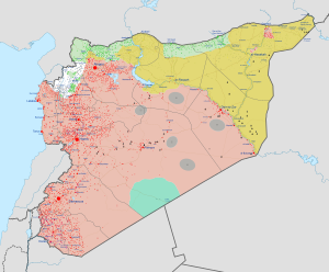

.svg)